


Displaying items by tag: Marine Notice
The main lay installation works for the Rockabill Subsea Cable will take place from tomorrow, Saturday 20 July, to Sunday 1 September.
Using the vessel CS Teliri (callsign IBBT), the Rockabill cable system will be conducted from north of Lambay Island across the Irish Sea to Southport in England.
The cable itself is armoured and has an OD of 38mm. The cable ship will firstly clear the route of seabed debris with a grapnel before installing the cable.
During installation operations, the vessel will be moving slowly along the route while towing a sea plough to bury the cable into the seabed. During these works the vessel will have restricted manoeuvrability as it completes the work scope.
Deployed guard vessels will monitor the exposed areas of cable at crossing locations while burial progresses.
Ships are asked to avoid using anchors, bottom-trawl fishing and other seabed gear within half a mile of this cable route, and to maintain a safe distance from the cable ship during installation operations and that static gear be relocated from the route prior to commencement of operations.
Vessels are requested to pass at a safe speed and distance and fishing vessels are advised to remain a safe distance from the areas identified. Guard vessels will be deployed at certain cable crossing points to aid in monitoring the exposed areas and will advise of safe distances locally. The vessels will monitor VHF Channel 16 at all times.
The location co-ordinates of the operation are as included in Marine Notice No 24 of 2019, a PDF of which is available to read or download HERE.
Marine Notices: ADCP Deployment In Waterford Harbour, EirGrid Interconnector Cable Survey In Irish Sea
TechWorks Marine Ltd is deploying trawl-resistant bottom mounted Acoustic Doppler Current Profiler (ADCP) frames in Waterford Harbour this week.
It is anticipated that the ADCPs will be deployed between today, Monday 8 July, and this Friday 12 July, depending on the weather. If the deployment is delayed due to the weather, it will be carried out on the next viable tide and weather window. Update: the ADCPs will now be deployed on or after Thursday 18 July.
The frames will be deployed from the vessel James (callsign EITT2). The frames will be on the seafloor for a minimum period of one calendar month and a maximum period of two months (weather permitting).
The ADCPs will be measuring currents through the water column at each location over the deployment. This data will be used to validate a hydrodynamic model of the area being developed for Irish Water.
Each frame will have one ADCP sensor, an acoustic pinger, an acoustic release and a rigid recovery buoy.
The frames are approximately 1m2 and will remain on the seafloor for a period of up to 30 days, after which the frame will be retrieved using the acoustic release and recovery buoy.
There will be no surface marker during the extent of deployment so vessel traffic will not need to avoid the area but should be aware of its presence.
Details of the relevant co-ordinates are included in Marine Notice No 22 of 2019, a PDF of which is available to read or download HERE.
Meanwhile, planned cable survey works on the EirGrid East West Interconnector are being carried out by the vessel Deep Helder (callsign PBYU) until this Thursday 11 July. During this survey, the vessel will be deploying underwater survey equipment along a thin 50m corridor.
Fishermen are advised not to leave any static fishing equipment in the vicinity of the survey route (250 metres) and keep a safe distance of at least one nautical mile from the survey vessels that will be operating with towed equipment and will have restricted manoeuvrability.
In addition, the survey vessel Ping will carry out operations in the near-shore waters off Rush, Co Dublin from next Monday 15 July. Near-shore survey operations will take place between beach HW mark and the 10m water depth contour.
Details of co-ordinates and survey contacts are included in Marine Notice No 21 of 2019, a PDF of which is available to read or download HERE.
Planned works on the Portrane Pre-Lay Shore End installation for the Rockabill Subsea Cable are being carried out from the coast of Portrane, Co Dublin.
Scheduled to start yesterday. Monday 1 July, they will continue to next Wednesday 10 July. During this first Pre-lay Shore End phase of the project, the cable will be installed and buried in the Irish Sea by the utility vessel Roxane Z (Callsign FIRJ).
The vessel will monitor VHF Channel 16 at all times. All vessels, particularly those engaged in fishing, are requested to give the Roxane Z a wide berth and keep a sharp lookout in the relevant areas.
Details and co-ordinates of the work area are included in Marine Notice No 20 of 2019, a PDF of which is available to read or download HERE.
Another recent Marine Notice includes an updated schedule of examinations for the Certificate of Competency for Deck Officers, Marine Engineer Officers, Skippers and Second Hands, commencing Monday 2 September this year.
A series of ecological surveys will take place in the Irish Sea off the Dublin and Wicklow coast between now and May next year to provide data on seabirds and marine mammal species to inform the development of the Dublin Array Wind Farm.
The survey dates are weather dependent but will comprise a survey in each calendar month until May 2020, commencing tomorrow (Monday 24 June), with additional monthly surveys this August and September.
The location of the surveys will be off the Dublin and Wicklow coast in the vicinity of the Kish and Bray Banks. Surveys will be undertaken in daylight hours and each will usually be completed over a period of two days.
For the initial survey, the work vessel will not be towing survey equipment. During subsequent surveys the vessels may be towing a hydrophone up to 100m astern and will be restricted in their ability to manoeuvre. Vessels are requested to leave a wide berth.
Details of co-ordinates of the survey areas, and relevant work vessels, are included in Marine Notice No 18 of 2019, a PDF of which is available to read or download HERE.
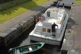
Waterways Ireland has issued Marine Notices related to a number of events taking place on Ireland’s inland waterways this weekend.
On the Royal Canal, a Junior Canoe Polo Competition will take place at Kilcock Harbour from 10am to 6pm tomorrow, Saturday 22 June.
Passage will be possible between 1pm and 2pm. Masters of other craft are requested to proceed at slow speed and with minimum wash and note any directions issued by the stewards.
On the Shannon-Erne Waterway, masters and owners of vessels are advised that they may experience short-term delays between Lock 1 at Corraquill and Ballyconnell Marina between 1pm and 6.30pm tomorrow due to the waterway’s 25th anniversary event.
Masters are requested to proceed at slow speed and heed any instructions issued by the event marshals.
Elsewhere on the River Shannon, the swimming element of a triathlon event will take place in Tarmonbarry on Sunday 23 June between 9.30am and noon.
Tarmonbarry lock will be closed to traffic during this time, and the N5 Shannon lifting bridge will also be closed, requiring large airdraft vessels to berth north of the bridge for the period.
A children’s swimming event will take place at 6pm on Saturday in Tarmonbarry, but this will not affect vessels in the navigation.
Masters are requested to proceed at slow speed and with minimum wash when approaching this section of the river and heed any instructions issued by the event marshals.
Meanwhile, on Upper Lough Erne, masters and owners of vessels are advised that dredging works are due to commence at Kilmore Quay on Monday 1 July and last for approximately nine weeks.
The map below shows the area to be dredged and the route the vessels will be taking in order to bottom-dump the material.
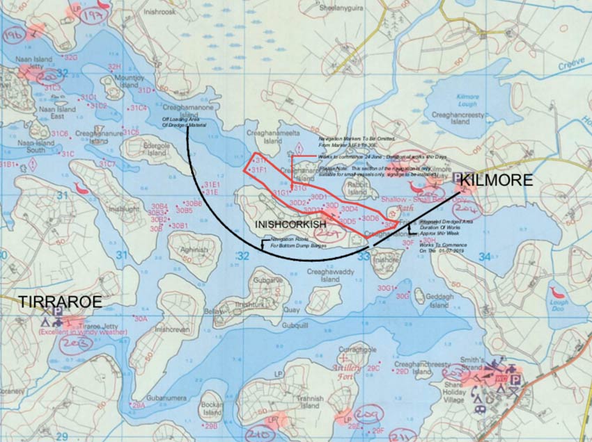
Masters of vessel are requested to proceed with additional caution in the vicinity of the dredging operations and dredging vessels.
Waterways Ireland thanks its customers for their co-operation in this and all other matters.
In response to the recent MCIB report on a fatal incident involving a fishing vessel in Galway Bay in November 2017, the latest Marine Notice from the Department of Transport, Tourism and Sport (DTTAS) related to the safety of small vessels engaged in pot fishing.
The notice is directed at users of vessels less than 15m in length:
- Those engaged in non-commercial potting are encouraged to familiarise themselves with the Code of Practice for the Safe Operation of Recreational Craft and to comply with the statutory requirements highlighted by the Code, and heed the safety advice and recommendations of the Code.
- Those engaged in commercial potting should comply with the Code of Practice for the Design, Construction, Equipment and Operation of Small Fishing Vessels of less than 15m length overall. The Code sets out requirements and recommendations relating to safety on board small fishing vessels.
In addition, the DTTAS reminds users of small vessels that:
- Suitable personal flotation devices (PFDs) and personal locator beacons (PLBs) should always be worn.
- Somebody ashore should be aware of where the boat is intending to operate and when it is expected to return.
- Vessels should have a suitable means of re-boarding in the event of a crew member falling overboard.
The DTTAS said it wishes to highlight the increased risks involved with single-person operation of such vessels.
Owners/skippers should carry out a risk assessment of the intended operations and take appropriate actions to reduce and/or mitigate the inherent risks that arise when nobody else is on board to render assistance or to raise the alarm.
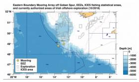
The German University of Bremen and the German Federal Maritime and Hydrographic Agency (BSH) have successfully deployed two scientific deep-sea moorings (called EB-1 and EB-3) at Goban Spur off the southwestern Irish shelf, similar to those deployed in 2016 and again last year.
The deep-sea moorings, which were deployed between 24 and 25 May, will stay in the water for a period of about 13-14 months (to June/July 2020).
Both have been anchored by ~1,000kg bottom weights. Scientific instruments are attached at different depths to ropes and chains. Sub-surface floatation bodies will keep the moorings upright.
The location of the deep-sea moorings is detailed in Marine Notice No 16 of 2019, a PDF of which is available to read or download HERE.
As this is sensitive scientific equipment, it is kindly requested that fishermen and marine operators engaged in such activities as bottom trawling or laying of static gear avoid the locations concerned to avoid damaging the equipment or damaging fishing gear.
None of the moorings has a surface element or surface buoy. The shallowest elements are located at depths of 700m (mooring EB-1) and 500m (mooring EB-3).
Top elements and floatation bodies have orange or yellow colours. The top elements of mooring EB-1 carries a flag.
Both moorings are equipped with radio and Iridium/Argos beacons that only signal, once the top element is at the surface.
Marine Notice: Cable Repair In Irish Sea Off Dublin
Marine Notice No 14 of 2019 advises that a cable repair for Emerald Bridge Fibres Limited (aka EBFL) is being conducted in the Irish Sea off the coast of Co Dublin.
Operations were scheduled to begin at 7pm on Saturday 1 June and will continue till 3am next Saturday 8 June.
The location of these operations is bounded by the following co-ordinates:
| Latitude | Longitude | |
|---|---|---|
|
A |
53° 29.00’ N |
005° 55.00’ W |
|
B |
53° 30.50’ N |
005° 46.80’ W |
|
C |
53° 28.00’ N |
005° 54.70’ W |
|
D |
53° 29.80’ N |
005° 46.20’ W |
A yellow buoy will be moored around Lat 53° 29.09’ N and Long 005° 51.35’ W.
The cable repair will be conducted by the Cable Ship (C/S) Pierre De Fermat (Callsign FIIZ). All vessels are requested to give the Cable Ship a wide berth of at least one nautical mile.
Fibre Optic Cable Laying In The Irish Sea This Weekend
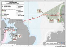
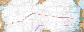
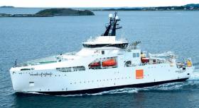
Marine Notice No 13 of 2019 advises that a pre-lay grapnel run and route clearance operations will be conducted in Irish waters for three days from tomorrow, Friday 31 May, to Sunday 2 June as part of installation of the marine part of the Havhingsten submarine fibre optic cable system.
The operations schedule is provisional, and will be subject to change due to external factors, including but not limited to weather, equipment or vessel downtime.
The location of the pre-lay grapnel run in Irish waters is indicated by Seg 1.1 in the map featured above, between Lat 53° 50.9' N, Long 004° 59.4' W and Lat 53° 38.6' N, Long 005° 40.5' W.
The pre-lay grapnel run will be completed by the cable ship Ile d’Aix (Callsign FICI). The vessel will be linked to the bottom by the cable and will have poor manoeuvrability capacities. It will signal that it has restricted ability to manoeuvre with shapes and/or lights as required by international regulations.
All vessels are requested to keep a clear distance from the cable laying vessel of at least 0.5 nautical miles. The cable laying vessel will broadcast regular safety messages giving its current position and activity.

The Defence Forces are currently conducting surface live firing practice shoots off West Cork, as per Marine Notice No 12 of 2019.
The practice shoots from today, Tuesday 28 May, to Thursday 30 May are taking place in Danger Area D13, in the coastal area south-south-west of Cork between Seven Heads and Galley Head and to seaward from 8am to 5pm daily.
The Danger Area comprises the sea area contained within the co-ordinates. The co-ordinates of area D13 are as follows:
| Latitude | Longitude |
|---|---|
| 51° 34.12’N | 008°42.36’W |
| 51°20.12’N | 008°34.36’W |
| 51°17.36’N | 008°48.48’W |
| 51°31.42’N | 008°57.06’W |
For the periods while the range is active, this sea area is out of bounds to all vessels. A Naval Service patrol vessel will enforce the Danger Area D13.
All vessels are advised that they are required to remain outside of the exclusion zone whilst the range is active, and are also recommended to carefully monitor the Radio Navigation Warnings that will be broadcast during the firing period.


 helicopter and fixed-wing aviation")
")


 John Stapleton, Robbie Quinn and Helm Alan Goucher")


 Michael Murphy Schull Harbour Sailing Club (SHSC), Eric Coogan Heineken Ireland, Mark Murphy, Commodore SHSC, Jack Allen SHSC, Carmel O'Regan SHSC, Cornelious Ndlovu, Schull Harbour Hotel Operations Manager and Derval Murphy SHSC")


