


Displaying items by tag: seismic survey
Study Links Seismic Surveys To Ocean Plankton Mortality

#MarineScience - New research raises questions over “significant disruption” to microscopic marine wildlife by seismic surveys — leading to calls for the Government to take notice.
According to The Irish Times, Lorcán Ó Cinnéide of the Irish Fish Processors’ and Exporters’ Association says the findings by researchers in Australia could explain anecdotal claims of reduced fish stocks in areas off the Irish coast where seismic surveys for oil and gas have taken place.
The new study, by marine scientists at the University of Tasmania and Curtin University, found that the air gun signals commonly used in seismic surveys of the seabed caused up to a 300% increase in ocean plankton deaths in the waters off Tasmania.
“Plankton underpin whole ocean productivity,” the study’s lead author Prof Robert McCauley said. “Their presence impacts right across the health of the ecosystem so it’s important we pay attention to their future.”
The Irish Times has more on the story HERE.
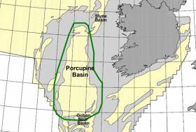
Marine Notice: 2D Seismic Survey In Southern Porcupine Basin
#MarineNotice - Nexen Petroleum Ltd advises that it will conduct a 2D seismic survey in the Southern Porcupine Basin off the South West Coast of Ireland this week.
The survey will commence on Wednesday 12 July and will last approximately six operational days, depending on weather conditions.
The aim of the proposed ‘Iolar’ geophysical survey is to accurately determine water depths, the nature of the seabed material and, locate and identify any seabed and sub-seabed features.
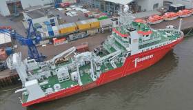
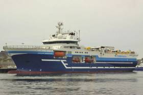
The vessel involved will be the M/V Fugro Venturer (Callsign C6CG3).
Full details of the survey area are included in Marine Notice No 30 of 2017, a PDF of which is available to read or download HERE.
As reported earlier today on Afloat.ie, another seismic survey is scheduled to begin this week some 210nm off Bull Rock.
Providence Resources is also currently drilling an exploration well at its prospect in the Southern Porcupine Basin.
Marine Notice: Seismic Survey Off South West Coast
#MarineNotice - Mullock & Sons (Shipbrokers) Ltd advises that a seismic survey is being conducted some 210 nautical miles west-southwest of Bull Rock Lighthouse off West Cork.
Operations are scheduled to begin tomorrow (Tuesday 11 July) with provision to start earlier on Friday 7 or Saturday 8 July, and will last three months, weather dependant.
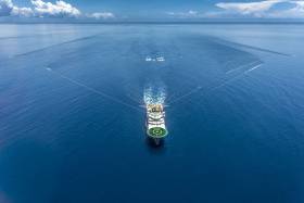
The vessels involved will be the seismic vessel Polar Marquis (Callsign LAOI5), which is towing a spread of 12 x 8100m cables with a width of 1,540m just below the surface.
The support vessel is the Moonrise GSL (Callsign HPEW) and the guard vessel is the Ary (Callsign YJQJ5).
There will be radio transmissions to vessels in the vicinity, with warnings broadcast on VHF Channel 16. Tail buoys will be used on the end of each streamer; they are yellow in colour and are equipped with strobing lights and radar reflectors.
At the end of each survey line, the vessel requires an area to turn around; this is some 15km in addition to the area confined within the coordinates given.
Full details of the survey area are included in Marine Notice No 29 of 2017, a PDF of which is available to read or download HERE.
3D Seismic Survey Expended In Porcupine Basin
#MarineNotice - Geoscience company CGG’s 3D seismic survey in the Porcupine Basin extends from today (Saturday 20 May) for the next 50 days, weather dependent.
Joining the survey previously reported last month is the Geo Caspian (Callsign 3FCZ6), accompanied by the Bourbon Tern (Callsign 5BDQ4) and the Mariska G (Callsign HO7662).
Yellow tail buoys will be towed at the end of each streamer, around 8.7km (4.7nm) behind the Geo Caspian. Each tail buoy will have a light flashing Morse code ‘U’ with an interval of approximately seven seconds.
Regular safety messaged will be broadcast from the Geo Caspian and its support vessels on VHF Channel 16 throughout the project.
Full details of the survey area are included in Marine Notice No 20 of 2017, a PDF of which is available to read or download HERE.
Seismic Survey Under Way In Porcupine Basin Till July
#MarineNotice - Geoscience company CGG is currently conducting a 3D seismic survey off the South West Coast of Ireland in the Porcupine Basin.
The three-month survey was scheduled to begin on Tuesday 11 April and will continue till Saturday 15 July. The vessels involved will be the Geo Coral (Callsign LACA8), Bourbon Tern (Callsign 5BDQ4), Marianne G (Callsign 3FTA9) and Stormbas 2 (Callsign V4EM2).
The Geo Coral is towing a multi-sensor streamer including 14 streamers with a 100m separation of an 8km length and a depth of 12 metres.
Yellow tail buoys will be towed at the end of each streamer, approximately 8.7km (4.7nm) behind the Geo Coral. Each tail buoy will have a light flashing Morse code 'U' with an interval of approximately 7 seconds.
There will be regular safety message broadcasting on VHF Channel 16 by the Geo Coral and accompanying vessels Marianne G and Stormbas 2 throughout the project. Seismic activity will be protected by support and chase vessels.
All vessels, particularly those engaged in fishing, are requested to give the Geo Coral and the towed equipment a wide berth and keep a sharp lookout in the relevant areas. In case of any doubt, call the Geo Coral on VHF Channel 16 and a safe course to follow will be given.
Full details of co-ordinates for the survey area are included in Marine Notice No 13 of 2017, a PDF of which is available to read or download HERE.
#MarineNotice - CGG Services SA is scheduled to carry out an extensive multi-client 3D seismic survey in the Porcupine Basin off the southwest coast of Ireland.
The seismic survey, named Ireland 2016 MC3D MSS, is further sub-divided into two areas called Area A (in the western area) and Area B (in the southern area).
CGG will start the seismic survey in Area A. The duration of survey in this area will be 25 days. Following the completion of survey in Area A, CGG will start acquiring Area B. This is expected to start late July 2016.
Survey Area A will cover 1,012 sq km and is anticipated to commence in the third week of June 2016. The expected duration is approximately 30 days, subject to weather conditions. Survey Area B will cover 4,078 sq km and is anticipated to commence in the third week of July 2016. The expected duration is approximately 65 days, again subject to weather.
The survey vessel RV Oceanic Endeavour (Callsign 3EJQ7) is scheduled to carry out the work. The vessel will tow 14 separate 8,100m-long solid streamers, with a separation of 100m and at depth of 12m below the surface of the water.
Active radar transponders and flashing navigation lights will be on the outer streamer tail buoys. The seismic vessel and equipment will traverse along pre-determined lines NW-SE across the operations area at a speed of approximately 4.5 knots.
The seismic vessel will be accompanied by support vessel MV Bourbon Grebe (Callsign 5BAT4) and guard vessel MV Stormhav (Callsign V4VD2).
Fishery liaison officers (FLOs) will be on board the RV Oceanic Endeavour to ensure communications with fishermen are clear and timely. All vessels engaged on this survey will be listening on VHF Channel 16 at all times throughout the project.
All other vessels, particularly those engaged in fishing, are requested to give the RV Oceanic Endeavour and her towed equipment a wide berth and keep a sharp lookout in the relevant areas.
Full details of the survey area are included in Marine Notice No 28 of 2016, a PDF of which is available to read or download HERE.
#MarineNotice - Following its scheduled survey under Licensing Option 16/14 later this month, PGS Geophysical AS is scheduled to carry out a second 3D seismic survey, this time in the North Porcupine Basin, from mid-June.
The survey over Frontier Exploration Licenses (FELs) 3/14 and 5/14 has been named 'Bréanann' and will cover 2,400 sq km over some 40 days, subject to weather. The same survey and support vessels will carry out this second survey.
Full details including co-ordinates can be found in Marine Notice No 21 of 2016, a PDF of which is available to read or download HERE.
Marine Notice: 3D Seismic Survey In Porcupine Basin

#MarineNotice - The latest Marine Notice from the Department of Transport, Tourism and Sport (DTTAS) advises that PGS Geophysical AS, on behalf of Woodside Energy (Ireland) Pty Ltd, is scheduled to carry out a 3D Seismic survey in the Porcupine Basin.
This survey, under Licensing Option 16/14 and named Granuaile, will cover 1,579 sq km and is anticipated to commence in the third week of May. The expected duration is around 35 days, subject to weather.
The survey vessel RV Ramform Vanguard (Callsign C6TU8) is scheduled to carry out the work. The vessel will tow 12 long solid streamers of 7,050m in length, with a separation of 120m and at depth of 20m below the surface of the water.
Active radar transponders and flashing navigation lights will be on the outer streamer tail buoys. The seismic vessel and equipment will traverse along pre-determined lines east-west across the operations area at a speed of approximately 4.5kts.
The seismic vessel will be accompanied by support vessel MV Thor Magni (Callsign C6BH9) and guard vessel MV Thor Chaser (Callsign J8B2384). Fishery liaison officers (FLOs) will be onboard the RV Ramform Vanguard to ensure communications with fishermen are clear and timely.
All vessels engaged on this survey will be listening on VHF Channel 16 at all times throughout the project. All other vessels, particularly those engaged in fishing, are requested to give the RV Ramform Vanguard and her towed equipment a wide berth and keep a sharp lookout in the relevant areas.
Full details of co-ordinates are included in Marine Notice No 20 of 2016, a PDF of which is available to read or download HERE.

#MarineWildlife - The Irish Whale and Dolphin Group (IWDG) has proposed a restriction of seismic survey activity on the slopes of the Irish continental shelf and the Porcupine Seablight.
The IWDG says its move "stems from an increasing body of evidence which indicates that the Irish Shelf Slopes and Porcupine Seablight are an important migration route and opportunistic foraging area for blue whales and fin whales from August to March each year.
"Humpback whales are also known to migrate along a similar route in the winter and early spring," it added in a statement.
The cetacean conservation charity as expressed concern at what it perceives as "a large increase in seismic survey activity in the Porpcupine Seablight during the main migration period and recent evidence of disturbance to these migrating whales by seismic surveys."
As a result, the IWDG has proposed to the Petroleum Affairs Division of the Department of Natural Resources that seismic surveys – such as that scheduled to be conducted in the Porcupine Basin this September – be "restricted to the months March to August, outside of the migration period, in order to minimise disturbance to these highly endangered whale species."
According to the group "similar measures" have been successful in other parts of the world, such as off South Africa, where whales "seasonally occur in large numbers".
The IWDG's proposal is available as a PDF to download HERE.
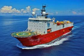
#CorkHarbour - Care of CorkHarbour.ie, here's a video introduction to the M/V Polarcus Amani, the modern 3D seismic survey vessel in Cork Harbour ahead of the largest offshore survey project of its kind in the South Porcupine Basin.
The Polarcus Amani represents the next generation of survey vessels that will be more and more common in Ireland's offshore waters as various companies explore the potential of our as yet untapped oil and gas reserves.


 is expected to be among the starters of the second ISORA Viking Marine Irish Coastal Race off Dun Laoghaire Harbour this Saturday morning")


 taking the treasured double - “provisional” first in line honours and first in Leg four IRC handicap ranking")


 Michael Murphy Schull Harbour Sailing Club (SHSC), Eric Coogan Heineken Ireland, Mark Murphy, Commodore SHSC, Jack Allen SHSC, Carmel O'Regan SHSC, Cornelious Ndlovu, Schull Harbour Hotel Operations Manager and Derval Murphy SHSC")


