


Displaying items by tag: Seabed
Mapping Ireland’s seabed, how scientists predict flooding and how to grow your own volcano are themes of an open day hosted by the Geological Survey of Ireland (GSI) and National Museum of Ireland this weekend.
The free “Down to Earth” open day event takes place on Saturday next, May 7th, at the National Museum of Ireland - Decorative Arts and History, Collins Barracks, Dublin.
GSI scientists will be on hand to “bring land and seabed mapping to life, to show the importance of groundwater, and reveal the secrets of Irish fossils,” the organisers state.
They will be joined by colleagues from DIAS (Dublin Institute for Advanced Studies), iCRAG (the Science Foundation Ireland research centre in applied sciences), Met Éireann, and Teagasc to answer questions on earthquakes, the metals we need for life, weather and flooding, and soil.
Members of the public are invited to “try and stump the geologist” by bringing a favourite rock or fossil to have it identified by a geology curator from the National Museum of Ireland.
Sustainable arts experts ReCreate will be running workshops for those families who would like to design some geology inspired art.
The open day takes its inspiration from “Down to Earth- Exploring Ireland’s Geology”, which is currently on exhibition.
Booking is not required, and members of the public can drop in to Collins Barracks, Dublin from 11 am on Saturday, May 7th.
Annual INFOMAR Seminar in Dingle to Focus on Role of Seabed Mapping in Coastal Communities
The annual INFOMAR Seminar is a celebration of the year’s work by Ireland’s national seabed mapping programme. INFOMAR is funded by the Department of Communications, Climate Action and Environment and is jointly managed and operated by Geological Survey Ireland and the Marine Institute.
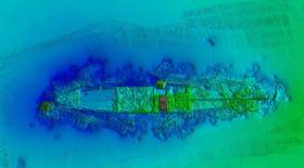
Attendees at the seminar, which will be held in Dingle, Co Kerry, on 16 and 17 October, will be among the first to see details of more than 8,500 of seafloor mapped, over 20 shipwrecks surveyed, and new 3D visuals of the coastal landscapes developed during the 2019 survey season.
The event will focus on Irish seabed mapping activities related to marine science, biodiversity, heritage and tourism in coastal communities. The event will feature an exciting line-up of experts presenting on; shipwreck mapping and archaeology, ocean literacy, marine ecology, ocean energy and infrastructure, as well as submerged and coastal landscapes and the connection between marine tourism and Fáilte Ireland’s Wild Atlantic Way.
Koen Verbruggen, Director of Geological Survey Ireland stated; “The INFOMAR seabed mapping programme continues to create significant positive impact at national, European and international levels, however this year’s annual conference in Dingle, Co Kerry, reflects INFOMAR’s prioritisation of engagement with local maritime communities who remain key stakeholders in Ireland’s national seabed mapping programme.”
“Ireland is an exemplar internationally in demonstrating best practice in ocean governance, through mapping, observing, predicting and managing our marine territory and resources. Connecting society with the value and importance of our ocean wealth is critical if we are to address today’s challenges, including climate change and population growth” said Dr. Peter Heffernan, CEO, Marine Institute.
Minister Canney stated; “INFOMAR, Ireland’s internationally renowned seabed mapping programme is an impressive example of inter-agency cooperation within the Government of Ireland. By holding its annual seminar event in Dingle Co. Kerry, I’m delighted to see the programme engage with its stakeholders at a local level, conveying its role in supporting the development of industry, research, heritage and tourism within coastal maritime communities”.
The INFOMAR Seminar will take place in the Dingle Skellig Hotel on Wednesday 16 and Thursday 17 October 2019. The event will include a special commemoration of the achievements of the Irish Baselines Project, and a live cast to MAREANO, the Norwegian marine mapping programme. Norway has just announced a new coastal mapping programme similar to INFOMAR which will complement the offshore activities of MAREANO. The event will conclude with a behind the scenes visit to Dingle OceanWorld Aquarium and to one of Ireland’s State research vessels, the RV Keary.
The event is open to all members of the public and interested people should register through the INFOMAR website www.infomar.com
Saving the Seabed May Not Cost the Earth After All
#seabed – A British government decision to slash 75 per cent of a proposed network of marine conservation zones (MCZs) intended to save seabeds and estuaries in England from being damaged by commercial and recreational activities, has been criticised by professional fishery managers.
The Department for Environment, Food and Rural Affairs (Defra) is proposing to go ahead with only up to 31 of 127 zones recommended by its advisors. It says it would be too expensive to set up more.
Responding to the watered-down proposals, the Institute of Fisheries Management (IFM) said it was "extremely disappointed" no more zones would be designated in the near future. Instead it called for "a clear timetable" for more, especially close inshore and for early discussions on how to manage and enforce them.
One zone the institute wants brought forward is in the Thames estuary which it says is one of the best studied estuaries in the UK, containing a wealth of well documented features fully meeting the MCZ criteria.
The estuary had long been a showcase for sustainable development. Most of the development challenges cited for delaying it were already being dealt with in a fully sustainable manner.
Another is the Alde-Ore estuary near Felixstowe, Suffolk. This contains a recruiting population of smelt (Osmerus eperlanus) a recognised MCZ flagship species. New evidence suggests a spawning run by these into the freshwater reaches of the estuary.
The institute agreed with the fisheries minister Richard Benyon that enforcing remote offshore zones could be costly, particularly if fishermen from other countries fished there.
Inshore, however, the use of sound and accessible science in selecting zones would engender strong commitment to self-enforcement among local sea users. Policing costs, including intelligence gathering, could then be "very low indeed."
There were already very good examples of self-enforcement in shell fisheries. In estuaries on the Thames and in Devon trawling restrictions had been maintained in an inclusive and coherent manner, at low cost.
Because Defra had not said how the zones would be managed and enforced the marine industry had, in some cases, provided "its own worst case scenarios," of the costs.
"This is an understandable reaction," according to Steve Colclough, chairman of the institute's marine section, "but it tends to militate against further designation [of more zones] in the near future."
Because of the uncertainty over management, some anglers felt that if estuaries became conservation zones they would be excluded from fishing in them. This was a factor in a number of cases and reassurances about a balanced approach carried little weight.
The institute was also disappointed the proposals did not refer to the socio-economic benefits of conservation zones. Around the world there was evidence they brought significant long-term benefits to fisheries, tourism and recreation. There had been early benefits to fishermen in recent examples of marine protection in England such as in Lyme Bay and Port Erin Bay on the Isle of Man.
Mr. Colclough said the institute was concerned about the balance of evidence and inconsistencies in some zone decisions. The rationale that estuaries, mudflats and salt marshes were some of the most productive aquatic ecosystems, was built into the reasoning for selecting some zones but not others.
The importance of conservation species such as the smelt had only been used in some decisions. For example, the Medway estuary was put forward for designation now, but data presented on the presence of a self-supporting population of smelt was not in the proposal. The institute said it was frustrating to be unable to see clearly where and how high quality information which it had provided had been used in making decisions.
"Such action tends to reduce the commitment and engagement so vital for success of these projects... We were promised [the MCZ process] would be transparent and fair, based on good science... Unfortunately we and others have noted specific data errors" which damaged the credibility of the whole process.
"These may seem small issues, but not to users who already feel threatened by the whole process. Understandable fear of the unknown quickly becomes antagonism."
As a professional body promoting more sustainable fisheries management, the Institute of Fisheries Management has a wealth of relevant experience, Mr. Colclough added, and said he looked forward to positive future engagement with Defra and others.
World Record Attempt by Irish-Raised Diver
#DIVING - Deep sea diver Sean McGahern is currently attempting the world record for cold water open sea diving in Malta.
The Times of Malta reports that McGahern - who was born in England but raised in Ireland before moving to Malta 17 years ago - entered the water at the Starfish Diving School before midnight last night, hoping to break the standing record of 11 hours and 46 minutes.
His previous attempt at the record was ended little more than an hour short of the record due to bad weather, but today's clear forecast has buoyed his confidence.
McGahern plans to pass the time by cleaning the seabed, assisted by a team of 16 safety divers, but he also intended to catch some sleep below the depths.
“I’ve slept underwater before," he said. "it’s not as difficult as you might think.”
McGahern, who previously held the warm water open sea dive record, is undertaking the challenge for Dar tal-Providenza, a home for the disabled on the Mediterranean island.
New Asgard Wreck Photos Released
After the publication of the MCIB investigation report into the sinking of Asgard II the dive team lead by Eoin McGarry have released further photos of the wreck, showing different aspects of the boat including new shots of the hole in the hull.
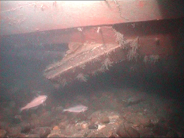
The "hole" in Asgard's Hull as it looked in July 2010 on the starboard bow, the long plank that was in the MCIB report pictures has fallen down and can no longer be seen. The view of the hole is harder to get now as the hull is listed to starboard and the seabed is silting up on the starboard bow and scouring on the port aft quarter and stern
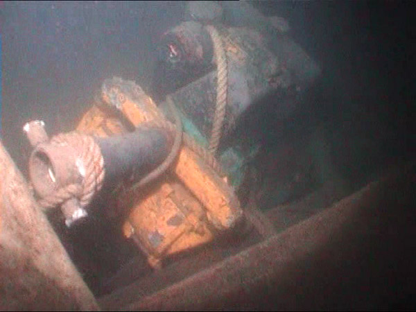
The salvage pump used. It is located midships on the starboard side
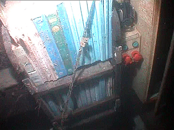
A selection of nautical reading material still remarkably intact. The photo of the bookshelf is taken in the absence of the roof/deck of the navigation room. This is directly forward of the helm, the door out of the navigation room was just to the left of the books as you look at them


 had the best result of the Irish Team at the Princess Sofia Regatta in Palma, finishing 14th overall of 114 boats after a 5th place finish on her final day of racing.")


