


Displaying items by tag: marine science
Valentia Island Aims to Lead Way in Hydrogen Energy Use
#islandnews - An island off Co. Kerry is aiming to produce clean energy which could be used to power public lighting and propel its ferry service, among other uses.
As the Irish Examiner writes, Valentia Island is planning to transform its energy needs through a potential hydrogen-based product.
The project which is community-led is based on a successful venture which has been continuing and developing on Scotland’s Orkney Islands since 2016.
Details of the proposed energy model will be outlined tomorrow in The Royal Hotel Valentia Function Room on the island in south Kerry.
The ultimate goal is to power the island, said Colum O’Connell, chairman of the Valentia Energy Group.
He said islanders would be able to pull up at hydrogen refuelling stations just as Orkney islanders currently do. Mr O’Connell said in the not-too-distant future Valentia could eventually be a powerhouse for storing and selling on the clean energy.
More on the story can be read here.
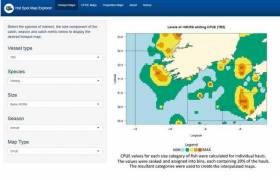
Marine Institute New "App" For EU's Fish Discard Ban
Eight years after British celebrity chef Hugh Fearnley-Whittingstall campaigned to end the EU’s wasteful practice of encouraging skippers to dump unwanted fish at sea, a new Marine Institute “app” aims to make life easier for Irish fishing vessels writes Lorna Siggins.
The mapping application to avoid discard “hotspots“ can be used by skippers working mixed fisheries, particularly in Irish and British grounds, who face a virtually impossible task due to the richly diverse nature of marine life.
The “app” draws on data to identify sea areas where they are more likely to catch unwanted fish which cut short the length of their fishing trip.
It was the EU’s own labyrinthine Common Fisheries Policy which had forced skippers to take measures like dumping unwanted species or undersized fish at sea – prompting one French skipper to observe that EU fish policy was designed as if the Atlantic was as simple as an “aquarium plugged into a computer”.
Irish industry organisations point out they had pioneered the development of selective gear technology long before Mr Fearnley-Whittingstall’s “Fish Fight” campaign of 2011 made headlines. However, there is no fishing gear yet developed which is so selective that it can retain only targeted species.
Recognising this, the Marine Institute “app” identifies grounds with consistently high catch rates of juvenile fish and “choke” species – as in the first species to hit the quota limit, which then effectively halts all further fishing.
Skippers using the “app” have the option of avoiding these areas, making the best use of selective gear technology, the Marine Institute says.
The Marine Institute researchers used observer data collected from Irish, British and French vessels in the Celtic Sea, and developed mapping techniques to identify consistent patterns in catches on Irish grounds.
The interactive technology on the “app” includes individual maps per species, which can be viewed based on vessel category, season, and size of the catch.
“While much of the information contained within these maps will be familiar to those regularly fishing in these areas... this tool could act as an additional resource .. in avoiding unwanted catches through spatial avoidance,” Julia Calderwood and Dave Reid of the Marine Institute say.
The first phase of what the EU describes as the “landing obligation” came into effect on January 1st, 2015, for pelagic – mackerel, herring and blue whiting – fisheries. The discard ban applied to all quota species from January 2019.
The institute, based in Galway, has been working with partners from 12 countries to develop strategies for the gradual elimination of discards as part of a project called “DiscardLess”, funded by the EU’s Horizon 2020 programme.
The Irish Fish Producers’ Organisation (IFPO) said it welcomed any initiative which would assist Irish vessels, given the degree of concern around the implementation of the discard ban. The IFPO plans to hold several workshops on the issue with vessel owners in co-operation with the State’s Sea Fisheries Protection Authority (SFPA).
Skippers using the “app” have been asked by the Marine Institute to provide feedback which may help to improve it through a short online questionnaire here
SeaMonitor Project Uses Marine Species Tracking Technology
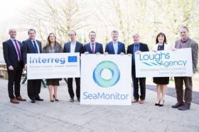
A unique marine research project, the first of its kind in Europe, studying the seas around Ireland, Western Scotland and Northern Ireland was launched this week in Derry–Londonderry. The SeaMonitor project is led by the Loughs Agency and supported by another eight leading marine research institutions using innovative marine species tracking technology to better understand and protect vulnerable marine life in our oceans.
Funding for the SeaMonitor project has been provided by the EU’s INTERREG VA Programme (Environment Theme), which is managed by the Special EU Programmes Body (SEUPB), to the tune of €4.6m. Match-funding for this project has been provided by the Department for Agriculture, Environment and Rural Affairs in Northern Ireland and the Department of Housing, Planning and Local Government in Ireland. This substantial investment will extend the existing network of ‘smart’ buoys and oceanographic models – delivered by sister projects COMPASS and MarPAMM – so that a line of acoustic receivers runs between the island of Ireland and Scotland.
The SeaMonitor project will deliver Europe’s largest telemetric marine array and spatial models supporting the conservation of basking shark, cetaceans, salmon, seals and skate. It will also provide three Management Plans; one for skate in the area from Loch Sunart to the Sound of Jura and two for salmon in both the River Foyle and Clyde estuaries.
Loughs Agency Designated Officer, Sharon McMahon, explained: “For over twenty-one years, the Loughs Agency has been at the forefront of protection and conservation of our local waters and aquaculture. So we are really excited to be leading the way alongside expert colleagues from statutory and academic institutions and a range of stakeholders that will ultimately produce dynamic management plans for some of our most important and vulnerable species”.
Welcoming the project Gina McIntyre, CEO of the Special EU Programmes Body, said; “The maritime territory across Europe is at risk from multiple challenges and must be protected for future generations of citizens. This tri-regional project will help to safeguard our precious shared marine environment by providing much-needed management and conservation work that will protect priority species and habitats, across Ireland, Northern Ireland and Western Scotland.”
John Speers, Marine and Fisheries Director at the Department of Agriculture, Environment and Rural Affairs in Northern Ireland, said “I am pleased to support the SeaMonitor project, which will use the best available technology to track some of our most important marine species. These animals spend the most of their lives hidden from view and are only occasionally seen at the surface, making monitoring them very challenging. The SeaMonitor project will help us better understand their life cycles and improve protection of these important marine species.”

#coastalnotes - As part of the RDS Library Speaker Series will be a presentation ‘Snapshots and Science - The Shallow Seas of Ireland’ which is to be held next Wednesday March 13 between 18:30-20:00.
The presentation by leading underwater photographer Paul Kay will feature an exploration of Ireland’s rich underwater world, one which is hidden from most of us and one which is still being explored.
It will showcase some extraordinarily beautiful species and locations and will also illustrate just how little we know and understand about the seas and how we utilise them. In an information rich era it will no doubt surprise many to see what lies below the waves.
The event held in the RDS, Ballsbridge, Dublin 4, is free of charge and open to all, but online booking is required. To book click here.
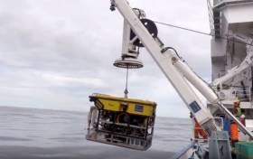
A team of marine scientists have discovered a very rare shark nursery, 200 miles west of Ireland while investigating Ireland’s deep ocean territory. The announcement was made at the INFOMAR Seabed Mapping Seminar in Kinsale today, where video highlights were debuted of this rare occurrence, discovered during the recent “SeaRover” survey by the Marine Institute’s remotely operated vehicle (ROV) Holland 1 deployed onboard the ILV Granuaile. The INFOMAR Programme is a Government of Ireland initiative, funded by Department of Communications, Climate Action and Environment and is a deliverable under Project 2040, Ireland’s National Development Plan.
Speaking at the event David O’Sullivan, of INFOMAR and Chief Scientist on the SeaRover survey (Sensitive Ecosystem Analysis and ROV Exploration of Reef habitat) said: ‘We are delighted to report the discovery of a rare shark nursery on a scale not previously documented in Irish waters. This discovery shows the significance of documenting sensitive marine habitats, and will give us a better understanding of the biology of these beautiful animals and their ecosystem function in Ireland’s Biologically Sensitive Area.”
During the SeaRover survey undertaken last July, the shark nursery was discovered while exploring Ireland’s deep-water coral reef systems. The exploration initiative was a collaboration jointly funded by the Irish Government (DAFM & DCHG) and the EU’s European Maritime and Fisheries Fund, supported by Marine Institute, NPWS, Geological Survey Ireland, & NUIGalway.
Speaking at the INFOMAR Seminar, Koen Verbruggen, GSI Director said “We are delighted that this discovery has been unveiled at todays’ event, demonstrating the importance of mapping our seabed habitats in understanding and managing our vast and valued ocean resources. Our data and team continue to make significant contributions to harnessing our ocean wealth.”
Very large numbers of egg cases, commonly called mermaids purses, were filmed on the seafloor at depths reaching 750 m. Such large concentrations of egg cases, are rarely recorded and indicate females may gather in this particular area on the seafloor to lay their eggs.
A large school of Blackmouth catshark (Galeus melastomus), abundant in the northeast Atlantic were present at the site, and it is likely the eggs are of this species. A second more unusual and solitary species, the Sailfin roughshark (Oxynotus paradoxus) was also observed. “Both species are of scientific interest as Ireland has an obligation to monitor deepwater sharks under the Marine Strategy Framework Directive”, said Maurice Clarke from the Fisheries Ecosystem Advisory Services at the Marine Institute.
The Sailfin roughshark is listed as ‘Near Threatened’ by the International Union for Conservation of Nature meaning it may be considered threatened with extinction in the near future. The species grows up to a length of 1.2 m and is usually observed moving slowly with deep water currents feeding on small benthic invertebrates. The individual may have been feeding on the eggs although this was not observed by the science team.
“No pups were obvious at the site and it is believed that the adult sharks might be utilising degraded coral reef and exposed carbonate rock on which to lay their eggs. A healthy coral reef in the vicinity, may act as a refuge for the juvenile shark pups once they hatch. It is anticipated that further study of the site will answer some important scientific questions on the biology and ecology of deep water sharks in Irish waters,” explained David O’Sullivan.
The shark nursery was observed within one of six offshore Special Areas of Conservation (SACs) in Irish waters designated under the EU Habitats Directive for Annex 1 reefs. The SACs host a diverse range of marine animals including sea fans, sponges, worms, starfish, crustaceans and a variety of fish species. Many of these species were apparent in the newly discovered nursery highlighting the importance of conserving key areas of our oceans to sustain and support marine biodiversity.
“Our key objective is to assess, protect and monitor Ireland’s rich offshore marine biodiversity so we can begin to manage our marine resources effectively. Without knowledge of what lives in our seas we are at risk of never fully understanding and appreciating Ireland’s marine environment”, Dr Yvonne Leahy (NPWS) explained.
Scientific expertise and the high resolution deep sea mapping dataset used in survey planning and design was provided by the national seabed mapping programme INFOMAR. This enabled targeting potential locations of reef habitat for this survey, in the form of seabed features including submarine canyons and seabed mounds, frequently host to cold water coral reefs and associated habitats in Ireland’s rich offshore waters.
The survey called ‘SeaRover’ is the second of three surveys commissioned and jointly funded by the Irish Government and the EU’s European Maritime and Fisheries Fund. ‘The cross-government initiative is supported by the Department of Agriculture, Food and Marine (DAFM), Department of Culture, Heritage and Gaeltacht (DCHG), and Department of Communications, Climate Action and Environment as part of the Marine Institute’s implementation of the Marine Biodiversity scheme. Survey operations were coordinated and led by the INFOMAR programme which is a joint venture between the Geological Survey Ireland and the Marine Institute, funded by the Department of Communications, Climate Action and Environment. Scientists from the Marine Institute, National Parks and Wildlife Service, National University of Ireland, Galway, Plymouth University and Aquafact participated in the survey which this year extended coverage to include Ireland’s farthest offshore area within its Exclusive Economic Zone at the Rockall Bank.
Minister Creed Addresses Ocean Leaders at Our Ocean Conference
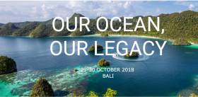
Minister Creed today attended the international Our Ocean Conference in Nusa Dua, Bali. This is the fifth of these conferences, started by former US Secretary of State, John Kerry, which brings together global community representatives and urges them to commit to tangible actions to ensure the future sustainability of the world’s oceans, and since 2014, the conference has produced commitments totalling in the region of US$18 billion.
In speaking during the panel discussion on Climate Change, Minister Creed outlined Ireland’s continued commitment to addressing the challenges raised by climate change stating that “the requirement to address knowledge gaps in relation to climate impacts within the marine/coastal environment have been identified as a prospective priority research area to enhance Ireland’s climate resilience”.
Minister Creed highlighted the provision of €10m to the local authority sector in Ireland to aid in the establishment of four Climate Action Regional Offices (CAROs), the continued commitment to the Environmental Educational module of Ireland’s Green Schools programme, continued support of the Clean Coast Programme and the provision of €1mil over a five year period (2019-2024) towards a new programme of Ocean & Climate research in an Irish Higher Education Institution.
Other commitments announced by Ireland included the completion of a €250 million naval vessel replacement programme involving the purchase of four larger more capable offshore patrol vessels tasked primarily with maritime surveillance and fishery protection, and Ireland’s commitment of €32 million for the delivery of three Pilatus 12 aircraft to the Irish Defence Forces in 2019/20.
Alongside the conference, Minister Creed attended a lunch, hosted by President of Indonesia Joko Widodo; met with the EU Commissioner Vella; met Irish attendees at the Our Ocean Youth Summit and met with the USA delegation to the conference to discuss the work of the Atlantic Ocean Research Alliance (AORA).
A scientific experiment, conducted by SEA-Tech a Cork based SME, under the control of a group of reputable witnesses composed of maritime professionals and researchers is set to enter the record books. The purpose of the experiment was to set a world record for the furthest maritime broadband transmission without satellite or cellular network using SeaFi wireless maritime communication system. Academic staff from Cork Institute of Technology (CIT) and The National Maritime College of Ireland (NMCI) and University College Dublin (UCD) were actively involved as reputable expert witnesses.
Dr Sean McSweeney, Lecturer in the Department of Computer Science in CIT and Sean O’Callaghan (NMCI), were tasked to conduct a thorough inspection at Roches Point Lighthouse SeaFi coastal station. Their experience, both as lecturer and system administrator, helped in establishing the fact that the lighthouse and the ship that would take part in the experiment were not connected to each other with any other system but a wireless radio link. Immediately after the inspection, the lighthouse was closed and keys kept by the Commissioners of Irish Lights when Prof Frederic Dias (Mathematician UCD) witnessing the operations in Roches Point Lighthouse, would take up position in the lighthouse with SeaFi coastal operator Theophile Buyssens from France. Prof Frederic Dias’ role consisted of calculating distance in real-time between stations.
Karle Grabe, Lecturer in the Department of Computer Science in CIT, and Capt Bill Kavanagh from NMCI, inspected SeaFi ship station on board OSV Ocean Spey in Ringaskiddy Deep Water Berth prior to departure. Their expertise in ICT and Nautical Science combined together guaranteed the results. Bill Kavanagh is a former sea captain (Emerald Isle Marine), nautical instructor and Head of Regional Fisheries, needless to say a well-seasoned seaman who knows his way around a ship. Assisting Karl Grab, a software development expert and a yachting enthusiast, both men inspected the bridge and the mast of the ship in search for any trace of connectivity other than SeaFi radio link before leaving the ship under the watchful eye of CIT graduate, Capt Mark Sloan and Chief Officer James Darwin.
SeaFi facilitates the creation of private telecommunication networks in ports and coastal areas by establishing the connection between lighthouses, maritime wind turbines, or offshore drilling platforms and vessels at sea. These networks are used to connect the ships and their crews, as well as the data collection buoys (weather, tides...) for example. SeaFI is a radio system on the frequency band of 2.4 GigaHertz which works a little like Marconi's telegraph system, using coastal stations (connection points) and embarked stations at sea. The key to the system is a bespoke ship antenna, which transmits wirelessly, and securely, over a private wireless network to special receiving shore antennas, one of which is attached to the Roche’s Point lighthouse “to put it simply, WiFi is more like a bare light bulb while SeaFi is more like a focused flashlight” says SEA-Tech.
The SeaFi ship station operator was Arnaud Disant, Marine Data Communications lecturer in NMCI and Marine ICT Engineer working with Port of Cork, Port of Waterford and Rosslare Europort. For the past decade, Arnaud Disant has been involved into the development of SeaFi working with maritime professionals, pilots and the Irish Naval Service.
Four bells in the afternoon watch, the ship left port at 14.00hrs. Expert witnesses from CIT, NMCI and UCD were in contact by email with the ship station operator. For several hours the Offshore Supply Vessel, owned by Mainport, had set course south of Roches Point Lighthouse in Cork Harbour. Every 15 minutes both operators in Roches Point, and on the bridge, kept running tests such as sending emails to the expert witnesses and making Skype calls. Emails leave traces when sent, expert witnesses Sean O’Callaghan, Carl Grabe and Dr Sean McSweeney would also confirm the emails originated from SeaFi ship station. Each email sent to shore, from the ship, was delivered without satellite or cellular connection. Once designed to guide ships into ports, lighthouses could be refitted to enter the digital era of marine big data.
At exactly 16:31hrs Roches Point issued one last message to the ship station, at 16:32hrs SeaFi ship station (code name Gemini) had gone silent after two and a half hours on uninterrupted transmission. OSV Ocean Spey was spotted on INS vessel LÉ James Joyce patrolling south west of Ocean Spey position. Prof Frederic Dias posted on Twitter the results of his calculation and was immediately echoed by expert witness, Lt Commander Brett, Commanding Officer of LÉ James Joyce reporting the position of Ocean Spey at Lat 51 30.05N Long 008 03.70W – 19.4 nautical miles from Roches Point (35.9 kilometres) at the time the last transmission was made. Evidence of the record has been sent to the Guinness World Book of Records for homologation.
The submission was supported by each individual independent expert witness.
Arnaud Disant, the engineer who invented SeaFi said: “SeaFi could put Ireland on the forefront of modern maritime technology.”It’s no doubt, this episode will be followed by many others, SeaFi is already attracting curiosity in The Netherlands, France, Italy, US and from as far away as Chile. Beyond the achievement itself, for an island nation, it’s a vivid example of academic staff teaming up actively together to support the research of a local SME.
Six Countries Team Up To Take Temperature Of The Atlantic
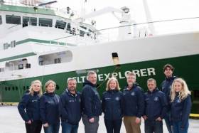
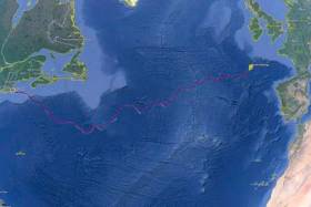
#MarineScience - An international team of marine scientists from six countries are currently sailing on Ireland’s national research vessel RV Celtic Explorer on a transatlantic voyage to study the impact of climate change on the ocean.
Departing from St John’s in Newfoundland on Thursday 27 April — after launching the miniature yacht Lancer a few days previously — and due to arrive in Galway on 23 May, the Marine Institute-led team of experts are surveying a transect of the Atlantic Ocean last surveyed 20 years ago to investigate carbon dioxide levels in the ocean.
The survey is essential to understand and project how carbon dioxide emissions are accumulated in the oceans and the atmosphere, as well as its effects on the acidification of the ocean.
The survey is part of the Global Oceans Ship-Based Hydrographic Investigations Program (GO-SHIP), which carries out systematic and global surveys of select hydrographic sections, through an international consortium of 16 countries and laboratories.
This is the first GO-SHIP survey to involve this level of collaboration with scientists from ten leading universities and research institutes representing six countries joining the survey.
Marine Institute chief executive Dr Peter Heffernan said: “The Marine Institute is proud to lead this truly international collaboration. This GO-SHIP A02 survey is a very real example of the Galway Statement in action: working together to better understand and increase our knowledge of the Atlantic Ocean and its dynamic systems, and promoting the sustainable management of its resources.”
The Galway Statement, signed at the Marine Institute 24 May 2013, launched the Atlantic Ocean Research Alliance between the EU, Canada and the USA.
The survey is co-ordinated by the Marine Institute and NUI Galway with research partners in Dalhousie University and Fisheries and Oceans, Canada; University of Exeter, United Kingdom; GEOMAR, Germany; Woods Hole Oceanographic Institution and Columbia University, USA; and Aarhus University, Denmark.
“Ship-based surveys are still the only way to collect the best quality measurements of fundamental physical, chemical and biological properties known as Essential Ocean Variables,” said Dr Evin McGovern of the Marine Institute and principal investigator on the GO-SHIP A02 survey.
“Although technology has provided many new methods to collect ocean measurements, there’s really no substitute for going out on the ocean on a research vessel.
“We can use satellite technology to look at certain properties the ocean surface and can deploy autonomous argo floats to take some measurements to depths of 2000, but we need to carry out ocean surveys that can measure to get a complete picture of the chemistry of the ocean at different depths up to 5,000m.
“The transect we are surveying is a really dynamic area of the Atlantic for heat transport and carbon uptake and is hugely important to informing our understanding of our global climate and how the ocean regulates our climate,” added Dr McGovern.
“The Northwest Atlantic is one of the world’s largest sinks of carbon dioxide and despite progress in our understanding there’s still a huge lack of data as it relates to climate change’s impact on the ocean and what that means for the economy and society,” said Brad de Young, a professor of physics and physical oceanography at Memorial University, Newfoundland and an Ocean Frontier Institute researcher.
“Improving our scientific understanding and developing strategic and effective solutions for safe and sustainable ocean development requires sharing of expertise, international co-operation and exchange of data and best practices. And that’s what this voyage is all about,” adds Doug Wallace, Canada Excellence research chair at Dalhousie University.
Ocean Research Drone ‘Glider’ Recovered Off Baltimore
#MarineScience - A deep-ocean drone was recovered with the help of the Marine Institute off the coast of Baltimore in West Cork earlier this month.
The SILBO autonomous glider, deployed by Teledyne Webb Research USA from Falmouth, Massachusetts in April last year, was sent on a mission to cross the North Atlantic and gather data from the ocean.
SILBO is one of 16 gliders undertaking 128,000km of co-ordinated surveys following an ocean gyre around the five global ocean basins. as part of the Unesco-endorsed Challenger mission.
Gliders look like torpedoes but lack propellors and an engine, instead relying on a movable internal ballast and external moveable fins to move across the ocean. They contain large battery packs to power the movement of the fins and change the internal ballast, as well as to power the glider’s sensors for ocean monitoring.
"Gliders like SILBO are equipped with a variety of sensors that enable scientists to monitor the ocean temperature, salinity, currents and other ocean conditions as well as offering a picture of places in the ocean that traditional satellites and research vessels may not be able to,” explained Aodhan Fitzgerald, RV operations manager at the Marine Institute, which used its remote operated vehicle to help recover the drone off Baltimore on Thursday 9 March.
“By contributing real-time data to a global portal, deep-sea gliders enable marine scientists to mutually benefit by creating a better assessment and understanding of the ocean and evaluating the ocean environment.”
Gliders like SILBO have the ability to go where it is impractical to send people. They can travel major distances over long periods of time, moving both horizontally and vertically through the ocean, continually gathering data.
The drones are also programmed to surface at designated times throughout their mission, allowing them to transmit the data they have collected to shore while at the same time downloading new mission instructions.
This two-way communications ability allows gliders to continually gather information about the most important and diverse regions of our ocean basins.
The Marine Institute says it is currently developing its capacity to use such gliders as they are an important tool for marine scientists to study and map the dynamic features of the ocean.
"With the opportunity to learn more about deep-sea glider capabilities, SILBO will be used for a training session led by Teledyne Webb Research at the Marine Institute's facilities in Galway,” Fitzgerald added.
“This will involve Irish and international glider technicians learning how to overhaul the glider and prepare it for its next mission before it is re-deployed from Irish shores to complete further mission transects for this global initiative.”
Eel Fishermen Celebrated By IFI For Scientific Contributions
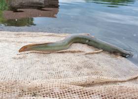
#Fishing - Local eel fishermen were celebrated recently at an information day hosted by Inland Fisheries Ireland in Athlone.
The fishermen, who are involved in IFI’s Scientific Eel Fisheries in different parts of the country, attended the event which aimed to provide an update on the progress made through these fisheries and to recognise the contribution of the fishermen to date.
In total, there are 11 fishermen involved in the initiative, with many experienced in fishing for eels over several years.
Since last year, they have provided support to IFI by fishing for eel in a conservation-focused manner with a view to gathering necessary data which will help protect the species into the future.
Their local expertise and historical knowledge around eels in their areaa has given invaluable support to IFI during the set up and delivery of the Scientific Eel Fishery.
IFI commenced the process of setting up a network of scientific fisheries for eel around Ireland in 2016. These scientific fisheries cover the different life stages — glass eel, elver, yellow and silver eel — and are distributed in key catchments around Ireland.
The purpose of the fisheries is to increase the knowledge around eels in Ireland ahead of the next EU review of this endangered species, and to inform the management of eel populations which are currently in decline.
Dr Cathal Gallagher, head of R&D at IFI, said: “This important partnership between eel fishermen and research has one shared objective: to improve our knowledge of the state of the eel populations and to ensure their conservation for future generations.
“Inland Fisheries Ireland appreciates the benefit of citizen science programmes such as this one which will preserve the heritage of eel fishing and at the same time deliver on the research requirements needed to report to the EU. I would like to recognise and thank all the fishermen involved for their support.”
Citizen science is growing in popularity and encompasses many different ways in which citizens who are non-scientists are involved in scientific research projects.
The involvement of fishermen in the Scientific Eel Fisheries plays an important role in respecting the tradition and heritage of eel fishing in Ireland. Many of the fishermen come from families where eel fishing has been practised across several generations with local expertise and knowledge passed down through the years.


 Michael Murphy Schull Harbour Sailing Club (SHSC), Eric Coogan Heineken Ireland, Mark Murphy, Commodore SHSC, Jack Allen SHSC, Carmel O'Regan SHSC, Cornelious Ndlovu, Schull Harbour Hotel Operations Manager and Derval Murphy SHSC")


