


Displaying items by tag: shipwreck
Mystery Of Shipwreck Washed Up on Newfoundland Coast
Archaeologists in Newfoundland are planning a survey of a wrecked ship which has recently washed up on the coast and may be up to 200 years old.
As the BBC reports, the 24 metre-long shipwreck was found by a boy hunting sea ducks near the shore outside Cape Ray, a coastal town in south-west Newfoundland.
There is speculation that the wreck, which would have been one of many caught by the large shallow rocks off Cape Ray, could have been dislodged from the seabed well over a year by Hurricane Fiona.
The hurricane hit Canada in September 2022, having travelled north from the Caribbean and through the Atlantic.
Wanda Blackmore, whose son found what seemed at first like "a dark object out in the water", told the BBC that it “could be the ship that brought my ancestors, or my husband's ancestors”,
Like many Newfoundland residents, she has English, Irish and Scottish roots, linked to the seasonal Atlantic cod fishery.
 A team of experts have been surveying the ship's wreckage in hopes of uncovering clues about its origin
The archaeological team has to survey the timbers before strong waves pull the ship away from the coast and towards deeper waters.
Neil Burgess, president of the Shipwreck Preservation Society of Newfoundland and Labrador, said it was hoped to “be able to piece together where this ship came from and how it ended up here”,
Read the BBC report here
Blackwater Divers Photograph Shipwreck in Bantry Bay That Lay Undiscovered for Nearly 200 Years
A diving team based in Fermoy have captured up-close images of a shipwreck that lay undiscovered in Bantry Bay for nearly 200 years.
The French naval frigate La Surveillante was deliberately scuttled by its captain in 1796 during the failed landing that proceeded the 1798 Irish rebellion against British rule.
It was not seen again until 1979 during clean-up operations that followed the Whiddy Island tanker disaster.
Blackwater Sub Aqua Club member Timmy Carey told The Corkman that he and his fellow divers had wanted to visit the wreck of La Surveillante for more than 20 years.
 Finbarr Mulchay and Susan Vaughan on the dive expedition to La Surveillante in Bantry Bay | Credit: Timmy Carey
“During the dive we saw numerous cannons, timber pulley blocks from the rigging, its anchors, cooking utensils, the high raised bow and even piles of small musket balls,” he said.
“We also saw the long sheets of copper plating that had been nailed to the outside of the timber hull for protection.”
The Corkman has more on the story HERE.
World's Deepest Shipwreck Found in Pacific
The world’s deepest shipwreck on record has been found by a team of explorers in the Philippine Sea.
The hull of the USS Samuel B Roberts, or Sammy B as it was known, was located at 22,916 feet (6984.7 metres) by a team involving explorer, private equity investor and former navy commanader Victor Vescovo of Caladan Oceanic Expeditions and British exploration company EYOS Expeditions.
Most of the world’s ocean floor is less than 6,000 metres deep, and areas deeper than that have tended to be linked to great tectonic trenches.
The Sammy B was one of several ships named after US Navy coxswain Samuel Booker Roberts, Jr., who died in the second world war Battle of Guadalcanal in 1942.
 The USS Samuel B Robert before it sank: It went up against much more heavily armed opponents Photo: US Navy
Roberts was part of a rescue mission for a company that had been surrounded by Japanese forces. He steered his vessel directly into the Japanese line of fire, and was mortally wounded.
The Sammy B, a destroyer, was commissioned in 1944 and was sunk by Japanese forces during the Battle of Samar later that same year. Two other US Navy ships were also later named the U.S.S. Samuel B. Roberts.
The Sammy B is reported to have damaged the Japanese fleet and delayed it for so long that it retreated, but the destroyer sank after it was hit with the loss of 89 lives. Some 120 crew on board were saved, after clinging to the wreckage for up to 50 hours according to BBC News.
“The Sammy B bore evidence of the incredible, ferocious fight that she waged against the cream of the Imperial Japanese Navy,” Vescovo told Jonathan Amos of BBC News.
“There were shell holes. She obviously had taken a massive hit from a battleship on her stern quarter [the rear of the boat], with it basically blown apart.”
Vescovo said that he was surprised they were able to find the ship because there was so little debris. It was broken in two, but he said it was relatively intact.
“Using a combination of detective work and innovative technology, everyone has pulled together to reveal the final resting place of this tenacious ship,” Kelvin Murray, EYOS expedition leader and director of expedition operations and undersea projects, said in a statement.
“It’s been challenging, thrilling and poignant expedition, one that recognises the ships and sailors from all nations who fought so hard during this battle.”
The same team discovered the U.S.S. Johnston last year in the Philippine Sea at over 21,000 feet – which then held the deepest wreck record until identification of the Sammy B.
Mr Vescovo was the first person to visit the deepest points in Earth's five oceans.
He's also climbed the highest peaks on each of the seven continents; and he recently went into space on New Shepard, the rocket and capsule system developed by Amazon.com founder Jeff Bezos.
Read more on BBC News here
Norwegian Divers Discover 300-Year-Old Wreck of Irish Sailing Ship
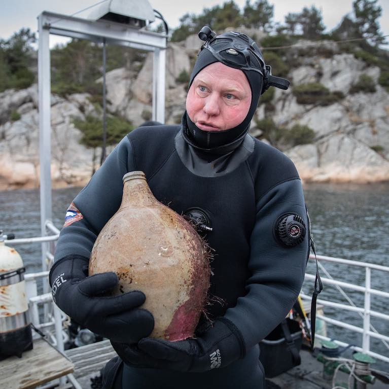
Norwegian divers have discovered a 300-year-old shipwreck of an Irish sailing ship on the sea bottom outside Mandal in Southern Norway.
The Irish ship, named "The Providentz", sunk in November 1720.
It is reported by the Norwegian NRK journalist, Siv Kristin Sællmann, that all crew members were saved, but the ship was left at the sea bottom. Divers and archaeologists are astonished by how well-preserved the ship and its possessions are.
The ship and most of the possessions will be left on the sea bottom for divers to explore freely.
Click here for a link to the article (text in Norwegian) but you can view more photos and a video of the wreck on the NRK TV website.
Sligo Shipwreck Mystery Solved – 250 Years After it Sank
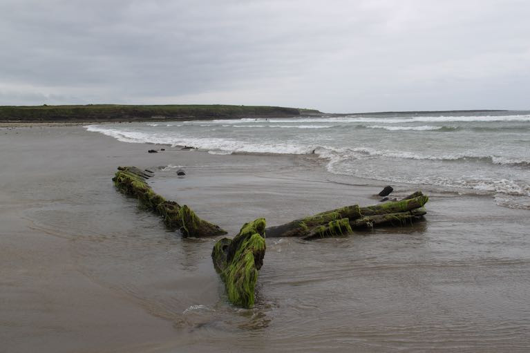
The National Monuments Service says it has resolved the mystery of a shipwreck off Co Sligo's Streedagh strand where three Armada ships are known to have foundered in 1588.
Research has confirmed that a wreck of a vessel off Streedagh known as "the Butter Boat" was a Yorkshire coastal trading ship, the Greyhound.
The ship from Whitby port sank with the loss of 20 lives on December 12th, 1770 - some 182 years after the Armada fleet.
The National Monuments Service, which marked the 250th anniversary with the local community last week, says that the Greyhound tried unsuccessfully to seek shelter in Mayo's Broadhaven Bay during a storm in December 1770.
It anchored off Erris Head in Co Mayo, but the crew was forced to abandon ship, leaving a cabin boy on board.
The National Monuments Service says that "on learning of the plight of the cabin boy, local volunteers from Broadhaven Bay, together with the crew of a passing ship from Galway and some of the original crew of the Greyhound showed extraordinary bravery in an attempt to rescue the boy and the stricken ship".
"While the rescue team did manage to board the Greyhound and move the vessel away from the cliffs, it was driven further out to sea by the force of the storm with some of the volunteer crew still on board, including the cabin boy, and later that night she was wrecked at Streedagh Strand, 100km to the east, with the loss of 20 lives," it says.
Oak timbers from the wreck were recorded and analysed by Denmark-based dendrochronologist Dr Aoife Daly as part of the research, which also included liaison with the Irish Folklore Commission’s Schools Manuscripts Collection, archived in University College Dublin.
An account given in 1937 by a Streedagh local, 75 year-old Michael MacGowan, to his granddaughter, told of a ship, described as a “tourist boat”, driven ashore at Streedagh Point some 200 years previously.
Mr MacGowan said all the crew bar one attempted to clamber to safety over the rocks at Streedagh Point but were drowned after falling into a deep recess between the rocks.
Later that night the ship re-floated on the rising tide and was washed ashore on the beach at Streedagh, where it grounded in the soft sands and is the vessel still visible today known as the “Butter Boat”, he said.
When the tide receded the following day, the one man who remained on the boat, Mr Williams, made it to the safety of the shore and, according to Mr MacGowan’s account, he returned "home" to England..
Dating sequences obtained from two samples had placed the construction of the vessel firmly in the first half of the 18th century, sometime after 1712, the National Monuments Service said.
"The analysis also indicated that the timber used in the construction was probably sourced from the English midlands or possibly Yorkshire,"it said.
" This provenance of the ship's timbers along with the 18th-century dendro date, clearly rules out any association between the ‘Butter Boat’ and the 16th century Spanish Armada campaign," it says.
Minister of State for Heritage at the Department of Housing, Local Government and Heritage, Malcolm Noonan welcomed the work put into confirming the events leading to the ship's loss.
“I know there is a huge amount of local interest in this wreck and that its identity has been a topic of debate for many years, with many calling it the Butter Boat and others thinking it part of the Armada, "Mr Noonan said.
He said he was struck in particular by "the value of folklore archives along with applied archaeological research in uncovering the full and tragic story of the Greyhound and those caught up in the tragedy’’.
“Its calamitous story illustrates starkly the perils of the sea but also highlights, how in times of trouble, the common bond of the sea brings people from different backgrounds together in an attempt to save lives," he said.
" I am proud that my department has been able to bring to light this story of tragedy and loss but also of extraordinary bravery, compassion, selflessness and heroism,"he said.
The commemoration with a wreath-laying at the wreck at Streedagh Strand on December 12th involved local residents, religious leaders and members of the National Monuments Service team.
"I am very appreciative of the continued community partnership between my our National Monuments Service and the Grange Armada and Development Association, Spanish Armada Ireland and Sligo Sub Aqua Club to promote, commemorate and keep watch over the internationally important wrecks of the Spanish Armada lost at Streedagh in 1588 and also the wreck that we now know is the remains of the Greyhound, "Mr Noonan said.
"We hold in our honoured custodianship the memory of those lost in the Spanish Armada wrecks and to that, we now add the memory of those lost in the tragic wrecking of the Greyhound 250 years ago," he added.
Details of this and other wrecks around the Irish coastline are on the National Monuments Service Wreck Viewer here
The Irish Folklore Collection details are here
Annual INFOMAR Seminar in Dingle to Focus on Role of Seabed Mapping in Coastal Communities
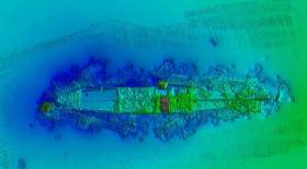
The annual INFOMAR Seminar is a celebration of the year’s work by Ireland’s national seabed mapping programme. INFOMAR is funded by the Department of Communications, Climate Action and Environment and is jointly managed and operated by Geological Survey Ireland and the Marine Institute.
Attendees at the seminar, which will be held in Dingle, Co Kerry, on 16 and 17 October, will be among the first to see details of more than 8,500 of seafloor mapped, over 20 shipwrecks surveyed, and new 3D visuals of the coastal landscapes developed during the 2019 survey season.
The event will focus on Irish seabed mapping activities related to marine science, biodiversity, heritage and tourism in coastal communities. The event will feature an exciting line-up of experts presenting on; shipwreck mapping and archaeology, ocean literacy, marine ecology, ocean energy and infrastructure, as well as submerged and coastal landscapes and the connection between marine tourism and Fáilte Ireland’s Wild Atlantic Way.
Koen Verbruggen, Director of Geological Survey Ireland stated; “The INFOMAR seabed mapping programme continues to create significant positive impact at national, European and international levels, however this year’s annual conference in Dingle, Co Kerry, reflects INFOMAR’s prioritisation of engagement with local maritime communities who remain key stakeholders in Ireland’s national seabed mapping programme.”
“Ireland is an exemplar internationally in demonstrating best practice in ocean governance, through mapping, observing, predicting and managing our marine territory and resources. Connecting society with the value and importance of our ocean wealth is critical if we are to address today’s challenges, including climate change and population growth” said Dr. Peter Heffernan, CEO, Marine Institute.
Minister Canney stated; “INFOMAR, Ireland’s internationally renowned seabed mapping programme is an impressive example of inter-agency cooperation within the Government of Ireland. By holding its annual seminar event in Dingle Co. Kerry, I’m delighted to see the programme engage with its stakeholders at a local level, conveying its role in supporting the development of industry, research, heritage and tourism within coastal maritime communities”.
The INFOMAR Seminar will take place in the Dingle Skellig Hotel on Wednesday 16 and Thursday 17 October 2019. The event will include a special commemoration of the achievements of the Irish Baselines Project, and a live cast to MAREANO, the Norwegian marine mapping programme. Norway has just announced a new coastal mapping programme similar to INFOMAR which will complement the offshore activities of MAREANO. The event will conclude with a behind the scenes visit to Dingle OceanWorld Aquarium and to one of Ireland’s State research vessels, the RV Keary.
The event is open to all members of the public and interested people should register through the INFOMAR website www.infomar.com
#diving –In a landmark case today two divers from Kent have been made to pay a total of £63,500 in fines and costs for not declaring valuable items from shipwrecks off the UK coast.
David Knight and Edward Huzzey, both from Sandgate, had previously pleaded guilty to 19 offences between them, contrary to section 236 and section 237 of the Merchant Shipping Act 1995. Knight was fined £7,000 and Huzzey £6,500. They were each ordered to pay £25,000 in costs.
Items were taken from shipwrecks off the Kent coast, with the first known objects removed in 2001. The shipwrecks targeted included German submarines from World War I and an unknown 200 year old wreck carrying English East India Company cargo.
The items included eight bronze cannons, three propellers from German submarines, lead and tin ingots, along with various other artefacts. It's thought the combined value of the items is more than £250,000.
The MCA is aware from diary entries that Knight and Huzzey used explosives and sophisticated cutting equipment to free wreck material.
It's believed that six of the cannons had been sold on, but in the last fortnight they have been returned to the Maritime and Coastguard Agency (MCA).
Taking this into account in passing sentence at Southampton Magistrates' Court, District Judge Calloway, said: "The scale of the operation has to be considered to have been on an industrial scale: the resources employed were valuable and substantial, using good quality lifting equipment and explosives. Huzzey and Knight are friends and clearly operated in close co-operation to actively scavenge for material from the wrecks they explored."
Alison Kentuck, the MCA's Receiver of Wreck, said: "It is not a case of 'finders keepers'. Our message is clear: all wreck material found within or brought within UK territorial waters must be reported to the Receiver of Wreck.
"Finders of wreck have 28 days to declare their finds to the Receiver. This case demonstrates what could happen to you if you don't. By reporting wreck material you are giving the rightful owner the opportunity to have their property returned and you may be adding important information to the historic record.
"Legitimate finders are likely to be entitled to a salvage award, but those who don't declare items are breaking the law and could find themselves, just like with this case, facing hefty fines."
English Heritage has provided expert advice in relation to uncontrolled salvage on submerged archaeological remains and on the handling of the seized artefacts.
Mark Harrison, English Heritage's National Policing and Crime Adviser, said: "The sentence today sets an important precedent in the fight against uncontrolled salvage by a small criminal minority who have no appreciation for our national maritime heritage. Sophisticated techniques and equipment were used by these men to remove valuable artefacts from the seabed."
Mark Dunkley, English Heritage's Maritime Archaeologist said: "English Heritage takes very seriously all cases of heritage crime which robs us of our shared history. However, we recognise that the majority of divers do act responsibly and comply with the laws and regulations relating to historic wreck sites and salvage."
Rondo Wreck Visit Reminder of Diving's Dangers

#Diving - With the Lusitania back in the news, Ireland's wealth of interesting diving sites are bound to draw attention this summer.
But it's worth remembering how dangerous an activity wreck diving can be - as Gizmodo reader Magicguppy relates in a special column for the tech news website.
He recalls his first ever shipwreck dive in September 2006, to the remains of the Rondo beneath the Sound of Mull in western Scotland.
"Used as a passage for shipping for centuries, it had a certain reputation for wrecking ships — even in 1935," writes Magicguppy, who goes on to depict in vivid detail how the ship went down, not to mention how the danger persists today for those who want to get close to the wreckage:
"The surface current swept my dive buddy and I towards the buoy. I turned and saw it gunning down on me. Grabbing the rope under the buoy, I signalled to my buddy.
"I knew that we had to get down below the current, and if we let go, even for a second, we wouldn’t be able to fight the current and get back onto the rope. My buddy agreed: Time to dive."
Gizmodo has much more HERE. But be warned - some of the gruesome descriptions in this story are not for the faint of heart!

#shipwreck – Silver recovered from the wreck of the SS Gairsoppa which was sunk by a German U-boat 300 miles southwest of Galway on February 17, 1941 is to be put on public display for the first time at an exhibition at Discovery Times Square in New York on May 24.
The SS Gairsoppa was a British steam merchant ship that saw service during the Second World War. The name Gairsoppa was given in honor of the stunning waterfalls in Karnataka, India. She sailed with several convoys, before joining Convoy SL 64. Running low on fuel, she left the convoy and headed for Galway, Ireland, until a German U-boat torpedoed and sank her.
The SHIPWRECK! exhibition features hundreds of authentic artifacts and historical treasures recovered from marine expedition firm Odyssey's deep-ocean projects from around the world.
Odyssey Marine Exploration recovered the silver from the 412 foot steel-hulled British cargo steamship at a depth of 4,700 metres below the surface. Recovery work began in 2012.
Odyssey recovered Silver from the wreck, which lies approximately three miles deep off the Galway coast will be going on display in the first public showing of some of the 1,218 silver bars of silver recovered the Gairsoppa, which is the heaviest and deepest recovery of precious metal from a shipwreck in history.
Shipwreck Highlights Danger of Portugal's Winter Winds
#Shipwreck - Two are reported dead after a shipwreck yesterday (Wednesday 10 April) on the Portuguese coast in what is a reminder to all cruisers of the dangers of strong winds in the region.
According to Portuguese language newspaper Publico, the deceased include one of the five crew of the German-flagged cruiser Meri Tuuli, and a member of the Portuguese maritime police attending to the incident who went into the water when his RIB overturned.
Eight people in total were admitted to hospital after the incident in which the Meri Tuuli - an X-442 yacht perated by a local sailing school - capsized on Cabedelo beach in Figueira da Foz, near Oporto.
Two are reported to be "wounded with traumatic injuries" while another two showed symptoms of hypothermia after exposure to the water.
Figueira da Foz is a popular cruising destination along the Iberian coast, but its port is vulnerable to the high swells that attract surfers to the area, sometimes closing altogether.
A source close to Afloat.ie described most harbour entrances along Portugal's west coast as "lethal during of after strong winter south or southwest winds" which are made stronger as air rushes into the valleys at river mouths as sea breezes.


