


Displaying items by tag: Geophysical Survey
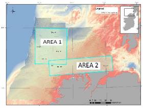
Green Rebel Marine in Crosshaven is set to undertake a geophysical survey operation in the Celtic Sea from next week.
The survey from next Wednesday 26 May to 23 June, weather permitting, will be conducted by the Roman Rebel (callsign 2ICA5) using hull-mounted multibeam and sub-bottom profiling systems.
In addition, the vessel will be towing side-scan sonars and magnetometers using dedicated winches at cable lengths dictated by the water depth. Typically, the cable lengths will be about four times the water depth while acquiring data.
The Roman Rebel will display appropriate lights and signals and all survey operations will be conducted 24 hours a day, continuous over day and night.
Full details of coordinates of the survey areas are included in Marine Notice No 32 of 2021, which can be downloaded below.
Following the recent notice of geophysical surveys for the Codling Wind Park comes news of a series of geotechnical surveys in the Irish Sea off Wicklow for the project set to commence tomorrow, Monday 26 April.
Works to characterise the wind park area will be conducted until Saturday 26 June, weather permitting, from the LB Jill (callsign WDH 6208) on a 24-hour basis. The vessel will display appropriate lights and shapes.
As the LB Jill will be restricted in ability to manoeuvre, all vessels operating within the work area are requested to keep their distance, maintaining a safety zone around the geotechnical investigation vessel, and pass at minimum speed to reduce vessel wash.
Further details including coordinates for the survey works are included in Marine Notice No 28 of 2021, which can be downloaded below.
Green Rebel Marine to Begin Geophysical Survey Off West Coast
Green Rebel Marine will conduct a geophysical survey campaign over 15 days between this Monday 26 April and Friday 4 June, weather depending.
The works, which will involve the use of multibeam echo-sounder and sub-bottom profiling systems, will take place at a number of locations off the West Coast
The survey will be conducted by the Roman Rebel (callsign 2ICA5), a semi-SWATH catamaran with all equipment hull-mounted which operates out of Green Rebel Marine’s base at Crosshaven Boatyard. The Roman Rebel will conduct 24-hour operations.
Further details including coordinates of the work areas are included in Marine Notice No 27 of 2021, which can be downloaded below.
Notice of Upcoming Geophysical Survey at Rockall Plateau, Porcupine Abyssal Plain & Porcupine Seabight
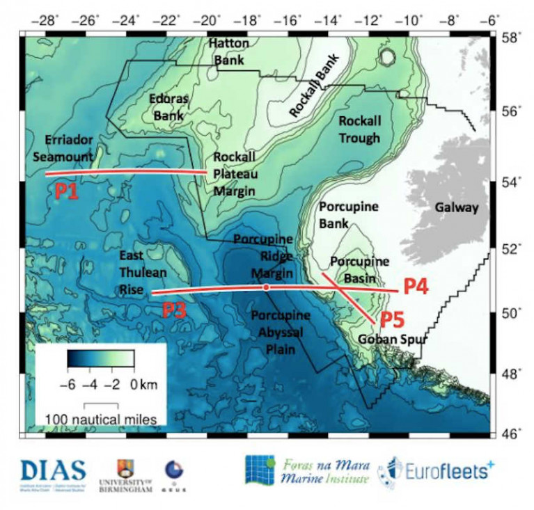
The Department of Transport has been advised that a marine geophysical survey will be carried out from 5-30 May southwest of Rockall Plateau and across the Porcupine Abyssal Plain and Porcupine Seabight.
This survey is part of the Irish marine research programme project PORO-CLIM and is being carried out with the support of the EU Eurofleets+ programme (Project PORO-CLIM, Survey Code CE21008).
The survey will be conducted by the RV Celtic Explorer (callsign EIGB). The vessel will display appropriate lights and signals. All survey operations are 24 hours, continuous over day and night.
The vessel will on occasion be towing a hydrophone cable and other equipment up to a maximum of 1,000 metres behind the vessel. The vessel will be restricted in its movements when towing a cable astern.
Full details of coordinates for these survey works are included in Marine Notice No 17 of 2021, a PDF of which can be downloaded below.
Geophysical surveys are being undertaken in the Irish Sea in outer Dundalk Bay from this week.
The work is required to provide bathymetric and subsurface information for the development of the Oriel Wind Farm project.
Survey work was expected to start yesterday, Tuesday 20 August, with a view to completion by Monday 30 September, though these dates are weather dependent.
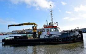
The surveys will be completed using the AMS Retriever (Callsign MEHI8), a versatile multi-purpose, shallow draft tug.
This vessel is towing survey equipment up to 100 metres astern and will be restricted in its ability to manoeuvre.
Other vessels are requested to leave a wide berth. The AMS Retriever will be operating from approximately 6am to 9pm during survey works.
Details of co-ordinates of the survey area are included in Marine Notice No 29 of 2019, a PDF of which is available to read or download HERE.
Geophysical & Environmental Site Survey Off South Coast

A seabed debris clearance, environmental baseline and habitat assessment site survey will take place in licence SEL 1/11 (Barryroe) from later this month.
Barryroe is located in the North Celtic Sea, some 50 kilometres south of the Port of Cork.
The project is scheduled to commence in mid-August 2019 with the survey vessel Kommandor (callsign MCJO2) anticipated to be working on location for 16 days, excluding transit and any weather delays
Survey operations will be conducted on a 24-hour basis in different phases to include towed and non-towed operations. A fisheries liaison Officer will be on board for the duration of the survey.
Throughout the survey operations, the vessel will be displaying appropriate shapes and lights to indicate that the survey vessel is restricted in its ability to manoeuvre.
All vessels are requested to give this operation a wide berth. A listening watch will be maintained on VHF Channel 16, and the vessel will actively transmit an AIS signal.
Full details of the site survey co-ordinates are included in Marine Notice No 27 of 2019, a PDF of which is available to read or download HERE.
Upcoming Hydrographic & Geophysical Surveys In The Irish Sea For Arklow Bank Wind Park
Hydrographic and geophysical surveys will be undertaken in the Irish Sea off the Wicklow coast between June and September 2019 to provide bathymetric and subsurface information to facilitate the development of the Arklow Bank Wind Park.
The survey dates are weather dependent but are anticipated to start in June and be completed by the end of September.
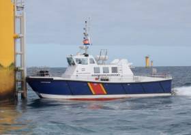
The location of the surveys will be off the Wicklow coastline. They will be completed using two vessels working in parallel across the site. The vessels involved are the AMS Panther (Callsign: 2EHC2), which is a 17m windfarm support catamaran, and the AMS Retriever (Callsign: MEHI8) which is a versatile multi-purpose shallow draft tug.
Both vessels will be engaged in survey operations and will be restricted in their ability to manoeuvre. The vessels will be towing survey equipment up to 100 metres astern. Vessels are requested to leave a wide berth. The vessels will be operating 24 hours per day during survey works.
Details of the survey area and relevant co-ordinates are included in Marine Notice No 11 of 2019, a PDF of which is available to read or download HERE.
Geophysical Research Survey Off North West Coast In May
#MarineNotice - Maynooth University will carry out a geophysical research survey off the North West Coast of Ireland from next weekend.
Work is expected to commence on Sunday 6 May and last for approximately nine days, subject to weather conditions.
The Marine Institute’s research vessel RV Celtic Voyager (Callsign EIQN) is scheduled to carry out the works for the Mara survey, undertaken by researchers in Maynooth University to collect geophysical acoustic survey data as well as sediment grab and core samples.
The survey will use relatively low amplitude sound sources to image into the seabed including an echosounder and a sparker system, which will allow for the characterisation of seabed type to inform the deglacial dynamics of the climatically driven British Irish Ice Sheet.
The vessel will, on occasion, be towing a hydrophone cable and other equipment, up to a maximum of 50 metres behind the vessel. The vessel will be restricted in its movements when towing a cable astern.
All other vessels are requested to give the operation a wide berth. The vessel will be listening on VHF Channel 16 throughout the project.
Details of the survey area, relevant co-ordinates and contact information are included in Marine Notice No 19 of 2018, a PDF of which is available to read or download HERE.
Geophysical Survey Off South & East Coasts Later This Month

#MarineNotice - Marine Notice No 11 of 2017 advises that a geophysical research survey will be undertaken off the South and East Coasts of Ireland for 16 days from Tuesday 28 March.
The survey is a collaborative effort by researchers in iCRAG, the Irish Centre for Research in Applied Geosciences at University College Cork and the University of Bremen (Germany).
The aim of the survey is to collect geophysical acoustic data in the Irish sector of the Irish Sea and the northern Celtic Sea (including the Dungarvan/Waterford area). The data set will be primarily used to improve knowledge on the nature and formation of recent seabed sediments that were influenced by the Irish Ice Sheet during the last glaciation.
The survey data will help create a 3D geological model and revise existing sub-seabed models of the seabed sediments in the Irish Sea and the northern Celtic Sea.
The RV Celtic Voyager (Callsign EIQN) is scheduled to carry out the survey operations using relatively low amplitude sound sources to image into the seabed including an echosounder, a sparker and a micro air gun seismic system.
The vessel will on occasion be towing a hydrophone cable and other equipment up to a maximum of 250 metres behind the vessel. The vessel will be restricted in its movements when towing a cable astern.
There will be a regular safety message broadcasting on VHF Channel 16 throughout the project.
All vessels, particularly those engaged in fishing, are requested to give the RV Celtic Voyager and towed equipment a wide berth, and keep a sharp lookout in the relevant areas.
A map and co-ordinates of the survey areas are included in Marine Notice No 11 of 2017, a PDF of which is available to read or download HERE.
Marine Notice: Hydrographic & Geophysical Survey Off Mayo Coast, Celtic Sea & Irish Sea
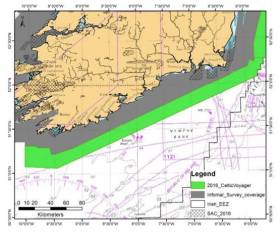
#MarineNotice - The latest Marine Notice from the Department of Transport, Tourism and Sport (DTTAS) has been advised that a hydrographic and geophysical survey operation will be undertaken by INFOMAR for the Sustainable Energy Authority of Ireland (SEAI) off the Mayo coast, in the Celtic Sea and also in the Irish Sea between 21 March and 30 October 2016.
The RV Celtic Voyager (Callsign EIQN), the RV Celtic Explorer (Callsign EIGB), the RV Keary (Callsign EIGO9), the RV Geo (Callsign EIDK6) and the RV Tonn (Callsign: EIPT7) are expected to carry out survey operations and will be listening on VHF Channel 16 throughout the project.
Details of co-ordinates for the survey operations are included in Marine Notice No 11 of 2016, a PDF of which is available to read or download HERE.


 Michael Murphy Schull Harbour Sailing Club (SHSC), Eric Coogan Heineken Ireland, Mark Murphy, Commodore SHSC, Jack Allen SHSC, Carmel O'Regan SHSC, Cornelious Ndlovu, Schull Harbour Hotel Operations Manager and Derval Murphy SHSC")


