


Displaying items by tag: INFOMAR
Marine Notice: Hydrographic & Geophysical Survey Off Mayo Coast, Celtic Sea & Irish Sea
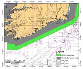
#MarineNotice - The latest Marine Notice from the Department of Transport, Tourism and Sport (DTTAS) has been advised that a hydrographic and geophysical survey operation will be undertaken by INFOMAR for the Sustainable Energy Authority of Ireland (SEAI) off the Mayo coast, in the Celtic Sea and also in the Irish Sea between 21 March and 30 October 2016.
The RV Celtic Voyager (Callsign EIQN), the RV Celtic Explorer (Callsign EIGB), the RV Keary (Callsign EIGO9), the RV Geo (Callsign EIDK6) and the RV Tonn (Callsign: EIPT7) are expected to carry out survey operations and will be listening on VHF Channel 16 throughout the project.
Details of co-ordinates for the survey operations are included in Marine Notice No 11 of 2016, a PDF of which is available to read or download HERE.
World War I Shipwrecks Revealed In Irish Sea
#HistoricBoats - A team of scientists aboard the Marine Institute's research vessel Celtic Voyager has revealed detailed images of World War I shipwrecks in the Irish Sea.
The team, led by Dr Ruth Plets of the School of Environmental Sciences at Ulster University, set out to capture the highest resolution acoustic data possible of WWI shipwrecks lost in the Irish Sea, using a new multi-beam system (EM2040) on board the RV Celtic Voyager to get the best data ever acquired over these wrecks.
"We were able to capture the most detailed images of the entirety of the wrecks ever," said Dr Plets. "Some of the wrecks, which are too deep to be dived on, have not been seen in 100 years. So this is the first time we can examine what has happened to them, during sinking and in the intervening 100 years, and try to predict their future preservation state."
Among the shipwrecks surveyed were the SS Chirripo, which sank in 1917 off Black Head in Co Antrim after she struck a mine; the SS Polwell, which was torpedoed in 1918 northeast of Lambay Island; and the RMS Leinster, which sank in 1918 after being torpedoed off Howth Head, killing over over 500 people - the single greatest loss of live in the Irish Sea.
Marine Institute chief executive Dr Peter Heffernan welcomed the achievements of the survey, supported by the competitive ship-time programme, saying: "The multidisciplinary team is making an important contribution to understanding and protecting our maritime heritage and to our ability to manage our marine resource wisely."
Explaining how the survey was carried out, Dr Plets added: "We moved away from traditional survey strategies by slowing the vessel right down to allow us to get many more data points over the wreck, with millions of sounding per wreck."
"The detail is amazing as we can see things such as handrails, masts, the hawse pipe – where the anchor was stored – and hatches. Some of the vessels have split into sections, and we can even see details of the internal structure. With the visibility conditions in the Irish Sea, no diver or underwater camera could ever get such a great overview of these wrecks."
As well as acoustic imaging, the team collected samples from around the wreck to see what its potential impact is on the seabed ecology. Sediment samples were also taken for chemical analysis to determine if these wrecks cause a concern for pollution.
The project is carried out to coincide with WWI centenary commemorations, noted Dr Plets. "We often forget the battles that were fought in our seas; more emphasis is put on the battles that went on in the trenches. However, at least 2,000 Irishmen lost their lives at sea, but unlike on land, there is no tangible monument or place to commemorate because of the location on the bottom of the sea.
"In the Republic of Ireland there is a blanket protection of all wrecks older than 100 years, so all these will become protected over the next few years. To manage and protect these sites for future generations, we need to know their current preservation state and understand the processes that are affecting the sites."
The next step for the team is to use the data collected to create 3D models which can be used for archaeological research, heritage management and dissemination of these otherwise inaccessible sites to the wider public.
"There is so much data, it will take us many months if not years, to work it all up," said Dr Plets. "Some of the wrecks are in a very dynamic environment and we are planning to survey these vessels again next year to see if there is a change, especially after the winter storms. That will give the heritage managers a better idea if any intervention measures need to be taken to protect them.
"These data could well signal a new era in the field of maritime archaeology. We hope it will inspire a new generation of marine scientists, archaeologists and historians to become involved. Above all, we want to make the general public, young and old, aware of the presence of such wrecks, often located only miles off their local beach."
The research survey was supported by the Marine Institute, through its Ship-Time Programme, funded under the Marine Research Sub-Programme by the Government.
The diverse team included maritime archaeologists Rory McNeary from the Northern Ireland Department of the Environment and Kieran Westley from the University of Southampton; geologists Rory Quinn and Ruth Plets, both Ulster University; biologists Annika Clements from Agri-Food and Biosciences Institute and Chris McGonigle from Ulster University; Ulster University marine science student Mekayla Dale; and hydrographer Fabio Sacchetti from the Marine Institute who works on Ireland's national seabed mapping programme INFOMAR, run jointly with the Geological Survey of Ireland.
The team blogged about the seven-day survey at Scientists@Sea.
Seabed Mapping Achievements Showcased At INFOMAR Seminar In Waterford

#MarineScience - Seabed mapping activity and developments during 2014 will be showcased at the annual seminar of Ireland’s national marine mapping initiative, INFOMAR, was opened yesterday (Wednesday 22 October) at the Tower Hotel in Waterford.
The INFOMAR programme, dedicated to increasing awareness of Ireland’s marine landscape, carries out hydrographic and geophysical surveys of Irish territorial waters.
It is a co-operative research programme between the Geological Survey of Ireland (GSI) and the Marine Institute (MI) and is funded by the Department of Communications, Energy and Natural Resources.
This ambitious mapping initiative began in 2006, and in its first 10 years will successfully map 26 priority bays and three priority offshore areas.
Using INFOMAR resources, skilled experts based at the GSI and MI develop data products, primarily hydrographic and geological maps that detail the Irish marine territory. These maps are now available for scrutiny HERE.
Minister of State Joe McHugh TD, who was present at the opening, said: “The Government has been strongly supportive of this project, committing €15 million for the five-year period from 2014 to 2018.
"With this continued funding support, Ireland is at the leading edge of European work in marine mapping and in laying the foundations for the sustainable management of our ocean space."
The minster added that “this year a further €3 million is being invested under the INFOMAR project in surveying the gateways to our ports, mapping our fish spawning grounds, finding routes for marine telecommunications cables and selecting the best sites for ocean energy generation. All rely on accurate seabed mapping capability, which Ireland now possesses.”
The 2014 INFOMAR annual seminar will provide an update on progress and plans, and focus on the downstream value and application of the data to underpin development and growth across the marine sector.
New INFOMAR products and services are continuously evolving, and the event will see the launch of a new education programme, a prototype dive tourism mobile app, and INFOMAR Story Maps.
Welcoming the launch, GSI director Koen Verbruggen said that the long-term benefits to Ireland as a result of INFOMAR’s offshore mapping are significant, and include:
- Datasets that feed directly into updated nautical charts via the United Kingdom Hydroghaphic Office.
- Up-to-date advanced mapping facilitates greater awareness of Irish marine opportunities.
- The data are used in planning of protection and development offshore Ireland.
- This project is also highlighting data and knowledge gaps for further exploration and research.
- New international research links have been forged between the surveys and agencies, which is resulting in related projects and employment.
Dr Peter Heffernan, chief executive of the Marine Institute, said: "The Government has prioritised the marine as an area for further growth under the Harnessing Our Ocean Wealth Strategy and the information on Ireland’s vast seabed territory that INFOMAR is capturing and making available will provide a solid platform for sustainable development and growth."
Over 130 attendees are expected to attend the over the day-and-a-half seminar. The work of INFOMAR is also showcased in the latest episode of TV3's maritime documentary series Our Island, broadcast last night and which will be available to stream via the TV3 Player.
INFOMAR Develops Transatlantic Co-operation In Seabed Mapping Programme

#MarineScience - George Hanna, a student of the Benthic Acoustic Mapping and Survey (BEAMS) programme in the USA, recently joined the Irish INFOMAR team on the research vessel RV Celtic Voyager during an inshore survey of Mizen Head, Co Cork.
The INFOMAR team provided fieldwork training on board the RV Celtic Voyager using the newly installed EM2040 state-of-the-art multibeam technology to develop detailed maps of the seafloor, as well as a sub-bottom profiler to identify and characterise layers of sediment and rock and surrounding habitat.
Training support is hugely beneficial in developing academic and career opportunities in bathymetric and seafloor habitat mapping on both sides of the Atlantic.
“With the rapid growth of new technologies used in ocean surveying, it is important that undergraduate students get fieldwork experience which focuses on strengthening their skills that can be used in the workforce,” said Thomas Furey, manager of Advanced Mapping Services at the Marine Institute and joint INFOMAR programme manager with the Geological Survey of Ireland.
Collaboration with the College of Charleston and University of Washington’s BEAMS programme came about after focussed development of international INFOMAR industry and research relations in recent years.
This was instigated following the transatlantic co-operation agreement, the 'Galway Statement', signed at the Marine Institute in 2013.
INFOMAR, which hosts its annual seminar in Waterford next week, also supported the nomination of Jay Calvert, University of Ulster, who was recently awarded a Fulbright-Marine Institute Scholarship to attend three months each at Alaska Pacific University in Anchorage, and Northeastern University in Boston.
The BEAMS programme is widely recognised internationally for the output of many academically qualified ocean surveyors, however gaining vessel experience can be challenging.
Volunteering as a survey technician through the programme, George Hanna highlighted the benefits of working with INFOMAR onboard the RV Celtic Voyager, stating: “I was extremely lucky to come to Ireland to get hands on experience on the Voyager and to work with some of the best sonar technology equipment out there.
"Getting real experience during survey operations and deploying numerous ocean-survey related instruments certainly helps support me in expanding my academic opportunities and also getting future work in the area of seabed mapping”.
Uncharted Rocks & Revised Depths Round Ireland
#unchartedrocks – The survey ships of the INFOMAR project – the Marine Institute's Celtic Voyager and the Geological Survey's Keary, Geo and Cosantoir Bradan – have been busy recently, and a lot of previously uncharted rocks have now been surveyed and notified to the UK Hydrographic Office for inclusion on the charts writes Norman Kean of the Irish Cruising Club. A couple of known rocks have also had their depths revised shallower, and would now be recognised as a significant hazard to small craft.
The most important new discoveries are these (Admiralty Notices to Mariners numbers in brackets):
• Rock with 2m, 2 cables off Rush Bay (1381/2014)
• Rock with 1.2m, 2 cables east of Loughshinny pier (1381/2014)
• Rock charted at 3.4m, north-east of the Fastnet, re-surveyed at 2.2m (0496/2014)
• Rock with 0.8m, halfway between Colleen Og Rock and the shore, at Dingle
• Numerous rocks around Inishskinny and south of Inishbofin (2672/2014)
• Rock with 1.5m, 2 cables south-east of Knife Rock, at Benwee Head in Mayo (3994/2014)
• Ballyhiernan Rock, west of Fanad Head, resurveyed from 3.4m to 1.7m (2620/2014)
The leisure sailing community has also made its contribution. A rock with 0.1m was discovered in Crookhaven Harbour in July by the crew of the yacht Eleanda (3645/2014). Fortunately she didn't hit it, but when they looked over the stern at low water on their anchorage, there it was, lurking a metre down. And very, very solid.
Not every change has been for the shallower – Limeburner Rock, off north Donegal, has had its depth revised from 2m to 3.5m.
It may be true that the rocks don't move, but the ever-increasing accuracy of the charts means that our knowledge of their existence, position and depth is constantly improving. Don't assume that your chartplotter package will pick this up automatically – it's best to check. The relevant Notices to Mariners can be found on www.ukho.gov.uk.

#MarineNotice - Following from this weekend's survey in Donegal Bay, INFOMAR will undertake a hydrographic and geophysical survey off the West Coast in the Galway Bay area between 25 May and 7 June 2014.
The RV Celtic Voyager (Call sign EIQN) is expected to carry out the survey operations, which follow up on a previous survey completed in February.
The vessel will be towing a magnetometer sensor with a single cable of up to 100m in length.
She will also be displaying appropriate lights and markers, and will be listening on VHF Channel 16 throughout the project.
Details of the survey area are included in Marine Notice No 32 of 2014, a PDF of which is available to read or download HERE.
Marine Notice: New Hydrographic Survey In Donegal Bay
#MarineNotice - INFOMAR will undertake a hydrographic and geophysical survey in Donegal Bay next weekend 24-25 May.
The RV Celtic Voyager (Call sign EIQN) is expected to carry out the survey operations, which follow up on a previous survey completed last month.
Though the vessel will not be towing any instruments during this survey, she will have limited limited manoeuvrability due to survey line constraints.
The vessel will display appropriate lights and markers, and will be listening on VHF Channel 16 throughout the project.
Details of the survey area are included in Marine Notice No 31 of 2014, a PDF of which is available to read or download HERE.
INFOMAR Marine Mapping Pledge of €15m Over Five Years

Minister for Natural Resources, Fergus O'Dowd, T.D. today set out details of upcoming projects in the National Marine Mapping Programme (INFOMAR), and pledged Government commitment of €15m for the next 5 years, for the continuation of what he called "the most valuable resource for marine research and development in Ireland and beyond".
Covering some 125,000 square kilometres of underwater territory, the INFOMAR project is producing new mapping and integrated products covering the Irish maritime space. It provides seabed surveys, which are used in all activities from planning for offshore renewable energy projects to ensuring shipping lanes are safely charted.
Commenting today, Minister O'Dowd said: 'I am delighted to announce the continuation of the INFOMAR project. This is a world class undertaking which is providing crucial information towards the development of Ireland's 220 million acres that lie under the sea. I am particularly pleased to see the programme focus on adding value to the data and ensuring INFOMAR plays it's part in developing jobs and growth,"
The decision to continue the project was taken following a second full independent review of its operations by PricewaterhouseCoopers. The initial review, undertaken in 2008, concluded that the benefits to the state of completing the project are between 4 and 6 times the cost. The second review showed the project to be on track and recommended accelerated development of business and educational applications. Dublin Business Innovation Centre (DBIC) have now been contracted to work with the project on this area, including new products, apps, and educational resources.
In the eight years since it began, the INFOMAR project has conducted detailed surveys along the SouthWest, South and East coasts and completed mapping of most Irish bays and harbours including, Dublin, Cork, Shannon and Galway. To date the programme has helped produce:
New navigational charts
Shipwreck maps and books
New Marine Special Areas of Conservation
Data to underpin Foreshore Licensing
Maps for offshore renewable planning, cable and pipeline routes
Ireland's largest digital database of marine information
The programme is funded by Department of Communications , Energy and Natural Resources and managed by Geological Survey of Ireland (GSI), in conjunction with the Marine Institute (MI). Mapping is carried out using all of the states marine research vessels, the Celtic Explorer and Voyager managed by MI and the Keary, Geo and Cosantoir Bradan managed by GSI. The next phase of the project will include mapping of Lough Foyle, Lough Swilly, Broadhaven Bay, Youghal, Dungarvan and Drogheda. It will also see the launch of a range of new services, reports and apps.
Seabed Survey Seminar Tries To Bridge Gap Between Research And Industr
#INFOMAR - The annual INFOMAR Seminar on one of the world’s largest seabed mapping programmes took place this week at the University of Limerick from 9-10 October, with updates on Ireland’s national seabed mapping programme.
Archie Donovan of the Geological Survey of Ireland highlighted INFOMAR’s recent mapping achievements saying: “We have made significant progress towards the delivery of national targets identified in our national integrated marine plan, Harnessing Our Ocean Wealth, and supporting ocean energy, marine tourism, environment, and shipping and trade development and management.”
A key focus of the conference is to bridge the gap between research and industry and the potential for innovation, research, and business opportunities from the mapping data and activities.
Among the SMEs presenting their innovations in this area were Gavin Duffy of RealSim Ltd, who presented their mapping and visualisation technology, and Francis Flannery of SonarSim Ltd who spoke about the benefits of multidisciplinary research collaboration from an SME perspective.
“There are significant scalable commercial opportunities relating to INFOMAR supported technology outputs, linking industry needs to research applicationsm," said the Marine Institute's Tommy Furey.
"The programme has already generated industry partnerships, for example, Geomar and Highland Geosolutions, and there are global opportunities for Ireland to deliver marine technology solutions, leveraging the internationally recognised INFOMAR brand."
A session on ‘Mapping Requirements & Mapping Technologies’ included a presentation on the need for mapping of Ireland’s vast and valuable seaweed resources by Dagmar Stengel of NUI Galway.
Tim McCarthy of NUI Maynooth examined the use of unmanned autonomous vehicles in seabed mapping as well as the challenges that brings.
The seminar hosted by the Mobile & Marine Robotics Research Centre included a presentation by Dr Andy Wheeler of UCC about the Moytirra Vent, a new type of hydrothermal vent, discovered onboard the national research RV Celtic Explorer in 2011 by a team of Irish and international scientists.
There was also an update on the mapping of shipwrecks and collaboration between the Underwater Archaeology Unit and the INFOMAR Programme, as well as a look at the investigation of INFOMAR-mapped shipwrecks by divers on the North Coast of Ireland.
INFOMAR is a joint venture between the Geological Survey of Ireland and the Marine Institute, and follows on from the Irish National Seabed Survey.
Covering some 125,000 sq km of Ireland's most productive and commercially valuable inshore waters, INFOMAR will produce integrated mapping products covering the physical, chemical and biological features of the seabed, and has prioritised the surveying of 26 bays and three priority areas around the coast of Ireland.
For more information visit www.infomar.ie
INFOMAR Annual Seminar 2013

#INFOMARseminar – A two-day INFOMAR seminar hosted by the Geological Survey of Ireland and the Marine Institute is to start tomorrow (Wednesday 9 October) in Limerick City.
Integrated Mapping for the Sustainable Development of Ireland's Marine Resources (INFOMAR) is a joint venture between the Geological Survey of Ireland and the Marine Institute. The programme is the successor to the Irish National Seabed Survey.
INFOMAR covers some 125,000 km² of Irelands most productive and commercially valuable inshore waters.
The annual INFOMAR conference will see seminar delegates meet in the Pavilion of the University of Limerick (UL) which is to be hosted by the Mobile & Marine Robotics Research Centre.
The seminar will include an update on Ireland's national seabed mapping programme including survey operations and coverage, future plans, associated research along with poster sessions.
Places to attend the free seminar were made open to all, however registration has now closed as attendance is at capacity.
To request a late registration, contact Kevin Sheehan by email: [email protected], should places become available.
For further information visit: www.eventelephant.com/infomarannualseminar2013


 Michael Murphy Schull Harbour Sailing Club (SHSC), Eric Coogan Heineken Ireland, Mark Murphy, Commodore SHSC, Jack Allen SHSC, Carmel O'Regan SHSC, Cornelious Ndlovu, Schull Harbour Hotel Operations Manager and Derval Murphy SHSC")


