


Displaying items by tag: Marine Notice
Upcoming Hydrographic & Geophysical Surveys In The Irish Sea For Arklow Bank Wind Park
Hydrographic and geophysical surveys will be undertaken in the Irish Sea off the Wicklow coast between June and September 2019 to provide bathymetric and subsurface information to facilitate the development of the Arklow Bank Wind Park.
The survey dates are weather dependent but are anticipated to start in June and be completed by the end of September.
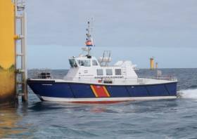
The location of the surveys will be off the Wicklow coastline. They will be completed using two vessels working in parallel across the site. The vessels involved are the AMS Panther (Callsign: 2EHC2), which is a 17m windfarm support catamaran, and the AMS Retriever (Callsign: MEHI8) which is a versatile multi-purpose shallow draft tug.
Both vessels will be engaged in survey operations and will be restricted in their ability to manoeuvre. The vessels will be towing survey equipment up to 100 metres astern. Vessels are requested to leave a wide berth. The vessels will be operating 24 hours per day during survey works.
Details of the survey area and relevant co-ordinates are included in Marine Notice No 11 of 2019, a PDF of which is available to read or download HERE.
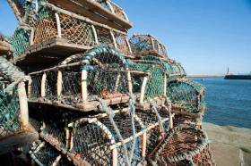
The Department of Transport, Tourism and Sport (DTTAS) has issued a new advisory over the risk of vessels becoming entangled in ropes used in pot fishing.
Marine Notice No 10 of 2019 supersedes No 26 of 2016 and reminds all vessel owners, agents, shipmasters, skippers, fishers, yachtsmen, seafarers and those engaged in pot fishing about the risks of vessels’ propellers becoming entangled in ropes of marker buoys used to indicate the position of pots used for fishing lobster, crab, or other fish or shellfish.
This can occur because the length of rope used to fix marker buoys is too long, resulting in the line floating on or just below the surface.
The use of too long a line of rope can result in a situation where even vessels that have taken a wide berth around marker buoys could have their propellers fouled by the rope.
In addition, the DTTAS reminds those engaged in pot fishing not to use unsuitable ‘floats’ (eg empty drink cans, plastic bottles, dark-coloured floats, etc) which offer poor visibility and/or could be mistaken for floating debris.
Fishers who carry out pot fishing (whether commercially or non-commercially) are reminded of their obligation to other users of the sea.
Furthermore, non-commercial pot fishers are reminded of the regulations made by the Department of Agriculture, Food and the Marine covering such activity (SI No 31 of 2016 Non-Commercial Pot Fishing (Lobster and Crab) Regulations 2016), which inter alia limits the numbers of pots permitted per boat to a maximum of six, and such pot fishing to the months of May to September.
Any mariners who spot any marker buoys/ropes (or any other object) in the water, which is deemed to represent a danger to navigation, should communicate information on same to other vessels in the area and to the Irish Coast Guard or to the local competent authority so that a hazard warning can be issued if appropriate, and any required follow-up action can be taken.
A guide for fishers and other users entitled ‘Good Practice Guide to Pots and Marker Buoys’ is included in the annex of Marine Notice No 10 of 2019, a PDF of which is available to read or download HERE.
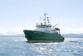
The first in a series of hydrographic and geophysical surveys to be undertaken in the Celtic Sea and Atlantic Ocean under the INFOMAR programme between April and October 2019 is now under way.
The RV Celtic Voyager (callsign EIQN) set off on Friday 12 April for an 18-day survey, the first of four over the next five months 18 May-6 June, 12-28 July, 29 August-14 September).
The RV Celtic Explorer (callsign EIGB) will follow up with an 18-day survey from 21 September to 8 October. Both vessels will be towing a magnetometer sensor with a single cable of up to 200 metres in length.
Other survey vessel involved include the Geological Survey Ireland vessels RV Keary (callsign EI-GO-9), RV Geo (callsign EI-DK-6), RV Mallet (callsign EI-SN-9) and RV Lir (callsign EI-HI-2).
All will display appropriate lights and markers and will be listening on VHF Channel 16 throughout the course of the surveys.
Full details of the survey areas are included in Marine Notice No 8 of 2019, a PDF of which is available to read or download HERE.
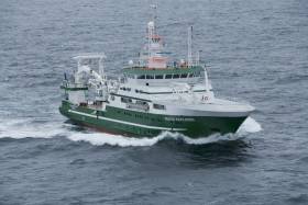
The annual Anglerfish and Megrim Survey has begun off the West South West and South Coasts of Ireland in fulfilment of Ireland’s Common Fisheries Policy obligations.
The purpose of this project is to carry out annual survey for relative annual abundance and distribution of anglerfish and megrim. However, other species of national
importance will also be sampled, along with physical and chemical oceanographic parameters.
IAMS 2019 runs till Monday 25 March. The demersal trawl survey consists of around 110 otter trawls (of 60 minutes each) in ICES areas 7b, 7c, 7g, 7h, 7j and 7k as indicated the map below.
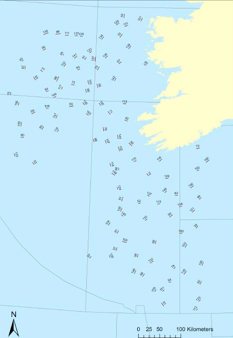
Fishing in 2019 will take place within a three-nautical-mile radius of all positions indicated.
The survey will be conducted by the RV Celtic Explorer (Callsign: EIGB). The vessel will display all appropriate lights and signals during the survey and will also be listening on VHF Channel 16. The vessel will be towing a Jackson demersal trawl during fishing operations.
Commercial fishing and other marine operators are requested to keep a 3nm area around the tow points clear of any gear or apparatus during the survey period. For more details see Marine Notice No 6 of 2019, a PDF of which is available to read or download HERE.
Marine Notice: Drills For Man Overboard Recovery On Fishing Vessels
The latest Marine Notice from the Department of Transport, Tourism and Sport reminds all concerned in the fishing industry of the existing requirements for drills and musters for man overboard recovery systems on all fishing vessels.
The legal requirements for these are laid out under the Merchant Shipping (Musters) (Fishing Vessels) Regulations 1993 SI No. 48 of 1993 and Merchant Shipping (Safety of fishing Vessels) (15-24 metres) Regulations 2007 SI No 640 of 2007.
These regulations require the skippers of fishing vessels to draw up muster lists for their vessels and exercise the crews of their vessels in the use of lifesaving appliances and firefighting appliances carried on their vessels.
The notice comes on the foot of a report published earlier this year by the Marine Casualty Investigation Board into a fatal incident involving the FV Kerri Heather in Arklow in November 2016.
Existing requirements in relation to drills/musters for vessels under 15m are included in Chapter 8.9 of the Code of Practice for the Design, Construction, Equipment and Operation of Small Fishing Vessels of less than 15m.
The skipper of every fishing vessel has overall responsibility for ensuring their crew know the location of the lifesaving and firefighting equipment on the vessel and are instructed, trained and drilled in the use of such equipment.
Full details of such skills — and the related DTTAS recommendations — are outlined in Marine Notice No 40 of 2018, a PDF of which is available to read or download HERE.
Brussels Issues Brexit Preparedness Notice On Maritime Security

#Brexit - The latest notice from the European Commission to stakeholders on Brexit preparedness concerns the field of aviation and maritime security.
Subject to any transitional arrangement that may be contained in a possible withdrawal agreement, as of the withdrawal date, the EU rules in the field of aviation security and maritime security will no longer apply to the United Kingdom.
In the maritime context, this will have consequences with regard to mandatory security information for passenger ferry services in the EU, from which the UK is exempt as a member state, and security inspections of vessels which the UK will no longer be able to carry out.
To date the Department of Transport, Tourism and Sport has published five Brexit preparedness notices relevant to maritime transport.
Full details of preparedness advice for maritime security are included in Marine Notice No 37 of 2018, a PDF of which is available to read or download HERE.
Marine Notice: Survey Operations For Subsea Cable In Irish Sea
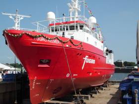
#MarineNotice - Fugro is currently carrying out marine operations in the Irish Sea on behalf of Alcatel Submarine Networks for the Havhingsten Subsea Cable System project.
The works from Loughshinny in North Co Dublin on an east-northeasterly route were scheduled to commence yesterday (Wednesday 26 September) and will last for around 30 days.
The vessel involved is the MV Fugro Helmert (Callsign: ZDNM8), which is running hull-mounted multibeam echo sounder lines along the proposed route.
Towing equipment such as magnetometer and side-scan sonar will be used during the shallow water phase, from around 105m of water depth and shallower.
The vessel will slow down or stop from time to time to measure the speed of sound in the water, and to perform geotechnical measurements.
A dynamic programme of survey is to be conducted in several stages. The survey vessel will be deployed within the working area at times and positions determined by client requirements, weather and sea conditions.
Inshore survey operations will be conducted on a 12-hour basis (daylight). Offshore survey operations will be conducted on a 24-hour basis.
Throughout the offshore survey, the vessel will be displaying shapes and lights prescribed in the International Rules for the Prevention of Collisions at Sea (COLREGS) Rule 27 to indicate that the survey vessels are restricted in their ability to manoeuvre.
A listening watch will be maintained on VHF Channel 16, and the vessels will actively transmit an AIS signal.
Details of co-ordinates are included in Marine Notice 35 of 2018, a PDF of which is available to read or download HERE.
European Commission Urges Preparedness For Brexit In Maritime Sector
#Brexit - The latest Marine Notice from the Department of Transport, Tourism & Sport (DTTAS) sets out the European Commission’s recommended actions for Brexit preparedness for all stakeholders that may be affected by the UK’s withdrawal from the European Union next year.
Examples of necessary legislative changes at an EU level are indicated in the communication attached to Marine Notice No 34 of 2018. Some of these relate to the maritime sector.
The DTTAS also draws attention to other technical notices published by the European Commission, which set out the legal and practical implications of a no-deal Brexit. The department has published four of these notices relevant to maritime transport:
- Notice to Stakeholders in the Field of Industrial Products
- Notice to Stakeholders on Seafarers Certificates
- Notice to Stakeholders in the Field of Maritime Transport
- Notice to Stakeholders – EU Ship Recycling Regulation
The relevant notices were attached to Marine Notice No 7 of 2018 and Marine Notice No 23 of 2018.
Full details of all previous stakeholder notices are available from the European Commission website.
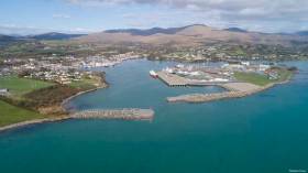
#Harbours - Works on the €23.5 million quay extension at Castletownbere Fishery Harbour Centre are due to begin by September.
As previously reported on Afloat.ie, Marine Minister Michael Creed attended the signing of the contract for the 216-metre Dinish Wharf extension with L&M Keating Ltd, after the project was green-lit this past May.
The works are being advanced by civil engineering crews working both from the adjacent lands, existing harbour infrastructure, and from jack-up barges, pontoons, heavy civil engineering plant and machinery, work vessels and platforms. Divers will also be also employed on site.
For safety reasons, mariners are advised to proceed slowly and with caution in the approach channel to the inner harbour, and within the inner harbour area, and to give the
works a clear berth. Wave wash from vessels should be avoided.
According to Marine Notice No 33 of 2018, these works are expected to continue till March 2020 and include, but are not limited to:
- Construction of a new quay structure approximately 216m at Dinish Island, including all associated infilling and land reclamation.
- Dredging of a berthing pocket adjacent to the new wharf extension by dredging to a depth of -8.0m Chart Datum.
- Dredging of a navigation channel to a depth of -6.5m Chart Datum.
- Construction of two new breakwater structures.
- Construction of a reclamation area to act as a quay/storage hinterland area.
- Provision of all water, electrical and fuels services.
- Heavy-duty pavement surfacing to new wharf/quay structure area
- Ancillary marine facilities and services.
- Relocation of navigation lights.
- Revised security and access arrangements for quay facilities.
#MarineNotice - Shell E&P Ireland Limited has begun a campaign of inspection of the Corrib Gas Field pipeline and associated infrastructure with repair and maintenance as required. Engineering tasks are also scheduled for well P3.
The near shore pipeline inspection was scheduled to commence in mid July and last for approximately 10 days. The offshore pipeline and subsea structure inspection along with the P3 work is due to commence in early August 2018 and last for approximately 14 days.
Visual and acoustic surveys will be conducted by means of sensors mounted on vessels and Remote Operated Vehicles (ROV) and cameras located on attendant survey vessels, ROVs and towed side scan sonar.
The near shore pipeline and umbilical sections will be inspected from the nearest point accessible inshore at high tide progressing to offshore until a suitable overlap with the offshore inspection is achieved.
The offshore inspection will commence at the Corrib field location and will continue towards shore until the vessel is required, on Marine Mammal Observer (MMO) advice, to relocate to the inshore inspection extent at safe navigation depth limit.
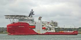
The vessel An Gearoidin (Callsign EIDL6) will undertake the near shore survey scope. All the equipment used will be vessel deployed. The Macbel and Blue Eagle will provide safety and welfare support to An Gearoidin.
The Siem Stingray (Callsign LAFP8) will undertake the deep water surveys and the subsea facilities maintenance and inspection. It will also carry out the P3 rectification work. All equipment used will be vessel and/or ROV mounted. All vessels will be listening on VHF Channel 16 throughout the project.
Full details of relevant co-ordinates and a map of the survey area are included in Marine Notice No 31 of 2018, a PDF of which is available to read or download HERE.


 Michael Murphy Schull Harbour Sailing Club (SHSC), Eric Coogan Heineken Ireland, Mark Murphy, Commodore SHSC, Jack Allen SHSC, Carmel O'Regan SHSC, Cornelious Ndlovu, Schull Harbour Hotel Operations Manager and Derval Murphy SHSC")


