


Displaying items by tag: Porcupine Basin
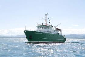
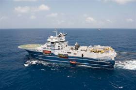
#MarineScience - Researchers at NUI Galway, along with partners at the Irish Centre for Research in Applied Geosciences (iCRAG) and the Marine Institute, are currently carrying out a marine hydroacoustic survey in the eastern margin of the Porcupine Basin.
Continuing till this Saturday 16 June, the project conducted from the RV Celtic Voyager (Callsign EIQN) involves generating an acoustic sound source (seismic airgun) adjacent to a short-term deployment of a hydrophone mooring and drifter array in order to investigate noise propagation across the Irish continental margin. The project is planned to inform research into noise pollution as part of Ireland’s obligations under the Marine Strategy Framework Directive (MSFD).
Approximate locations of fixed moorings and seismic noise transect are included in Marine Notice No 24 of 2018, a PDF of which is available to read or download HERE.
Fixed moorings will include yellow surface buoys with warning lights: high intensity, quick flash, continuous, yellow. The drifter will include a yellow surface buoy with nav light: 5 flashes every 20 seconds, yellow, 2nm distance.
The RV Celtic Voyager is displaying appropriate lights and signals and will be within the vicinity at all times throughout the survey.
Researchers also emphasise that the closest distance from survey to any marine SAC is over 16 nautical miles. Commercial fishing and other marine operators are requested to keep a 3nm distance from any survey instrument moorings, and to keep a 2nm distance around the entire survey area clear of any gear or apparatus during the survey period outlined above.
New Expedition Finds Deepest Ever Irish Corals
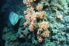
#MarineScience - A team of scientists have discovered the deepest known occurrence of a cold water coral reef known as Solenosmilia variabilis in Irish waters.
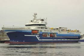
The marine scientists, led by the Marine Institute with the National Parks and Wildlife Service (NPWS), travelled over 1,000 nautical miles over three weeks along Ireland's Porcupine Bank and continental slope collecting HD video, sample cores and biological specimens from marine wildlife along the shelf edge from 50 locations.
They also explored the Atlantic Ocean to depths of more than 1,600 metres as part of a multi-agency and university collaboration using video mapping with the Marine Institute’s mini-submarine ROV Holland I.
The SeaRover survey was carried out on the Commissioner of Irish Lights vessel ILV Granuaile, gathering data for marine planning, habitat protection and measuring the effects of climate change.
“Some of the reef ecosystems and habitats we discovered have never been seen before, and discovering S. variabilis at depths greater than 1,600m helps us establish a better understanding of the environmental conditions necessary for this species to thrive,” said INFOMAR chief scientist David O’Sullivan.
"The deep-sea coral S. variabilis is widespread, normally seen at depths between 1,000 to 1,300m on seamounts or rocky areas deep under the sea but only occasionally forms reefs.
“Its growth rate is very slow approximately one millimetre per year, so finding the reef structure, which is part of a fragile ecosystem thousands of years old, in deeper parts of the ocean is an important find for marine science.”
Also found in this extreme deep sea environment were sea pens, which visually look like a cross between a feather, a starfish and a fern, but are are actually a form of soft coral.
“With over 300 species currently known around the world, they come in a variety of shapes, sizes and colours — we have seen a wide variety of forms on this survey, and can only give species names to very few as many are likely to be new to science and have yet to be described,” said Dr Yvonne Leahy of the NPWS.
“There are undoubtedly many more unidentified species out there and we ourselves have observed some specimens that require closer examination to properly identify.”
The team used the ROV Holland 1 to map the distribution and extent of deep water reefs and associated habitats, as well as using high-resolution bathymetric maps produced under the national seabed mapping programme INFOMAR, a joint initiative of the Marine Institute and the Geological Survey of Ireland.
The bathymetric data, which shows the depths of the ocean, has been key in identifying specific seabed features such as submarine canyons, escarpments and mounds where reef habitats are likely to occur.
The SeaRover (Sensitive Ecosystem Assessment and ROV Exploration of Reef Habitat) survey is jointly funded by the Government and the EU through the European Maritime Fisheries Fund and NPWS to undertake further mapping surveys of offshore reefs, with the aim of evaluating status and review requirements for conservation and management measures consistent with the Habitats Directive.
The project is co-managed by the INFOMAR programme and Fisheries Science and Ecosystem Services at the Marine Institute and NPWS. While the project objectives are primarily policy driven, the collection of data and scientific benefit will also be of immense benefit to the national and international research community.
The ROV robotic arms were also used to collect biological specimens for NUI Galway's SFI funded project ‘Exploiting and Conserving Deep Sea Genetic Resources’, and will also give new information on where sensitive species are found to help research at University of Plymouth’s Deep Sea Conservation Unit to predict where high value ecological areas might be identified offshore of Ireland and the wider North East Atlantic.
“The biological samples will help us understand the connectivity of different cold-water coral reef habitats, which will ultimately help with their future management,” said on-board senior scientist Dr Kerry Howell from Plymouth University.
This latest research mission comes less than two months after a team of university researchers and students on the RV Celtic Explorer explored cold water corals and sponges in the Whittard Canyon on the south-western edge of the continental shelf.
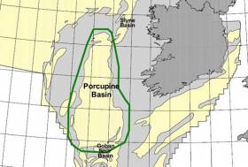
Marine Notice: 2D Seismic Survey In Southern Porcupine Basin
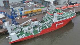
#MarineNotice - Nexen Petroleum Ltd advises that it will conduct a 2D seismic survey in the Southern Porcupine Basin off the South West Coast of Ireland this week.
The survey will commence on Wednesday 12 July and will last approximately six operational days, depending on weather conditions.
The aim of the proposed ‘Iolar’ geophysical survey is to accurately determine water depths, the nature of the seabed material and, locate and identify any seabed and sub-seabed features.
The vessel involved will be the M/V Fugro Venturer (Callsign C6CG3).
Full details of the survey area are included in Marine Notice No 30 of 2017, a PDF of which is available to read or download HERE.
As reported earlier today on Afloat.ie, another seismic survey is scheduled to begin this week some 210nm off Bull Rock.
Providence Resources is also currently drilling an exploration well at its prospect in the Southern Porcupine Basin.
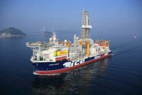
#MarineNotice - Providence Resources advises it intends to drill an exploration well in the Southern Porcupine Basin.
Operations were scheduled to begin today (Monday 3 July) to drill the well at a depth of 2,250 metres some 220km off the South West Coast of Ireland.
Drilling is expected to take 60 days to complete, subject to weather and operational delays.
The dynamically positioned drill ship Stena IceMax (Callsign 2FMJ5) will carry out the drilling, supported by platform supply vessels Sjoborg (Callsign OZ-2075), Edda Frende (Callsign LCOB) and Skandi Flora (Callsign LEVX). The emergency rapid response vessel is Esvagt Don (Callsign MZWQ6).
There will be a safety exclusion zone of 500m radius from the drill ship. Regular safety messages will be broadcast on VHF Channel 16 by Esvagt Don throughout the project. Radio navigation warnings will also be issued several times daily by the Irish Coast Guard.
All vessels, particularly those engaged in fishing, are requested to give the Stena IceMax and accompanying vessels a wide berth and keep a sharp lookout in the relevant areas.
Full details of the drilling area are included in Marine Notice No 28 of 2017, a PDF of which is available to read or download HERE.
3D Seismic Survey Expended In Porcupine Basin
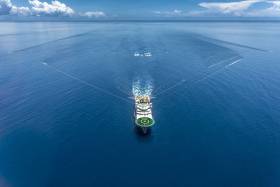
#MarineNotice - Geoscience company CGG’s 3D seismic survey in the Porcupine Basin extends from today (Saturday 20 May) for the next 50 days, weather dependent.
Joining the survey previously reported last month is the Geo Caspian (Callsign 3FCZ6), accompanied by the Bourbon Tern (Callsign 5BDQ4) and the Mariska G (Callsign HO7662).
Yellow tail buoys will be towed at the end of each streamer, around 8.7km (4.7nm) behind the Geo Caspian. Each tail buoy will have a light flashing Morse code ‘U’ with an interval of approximately seven seconds.
Regular safety messaged will be broadcast from the Geo Caspian and its support vessels on VHF Channel 16 throughout the project.
Full details of the survey area are included in Marine Notice No 20 of 2017, a PDF of which is available to read or download HERE.
Seismic Survey Under Way In Porcupine Basin Till July
#MarineNotice - Geoscience company CGG is currently conducting a 3D seismic survey off the South West Coast of Ireland in the Porcupine Basin.
The three-month survey was scheduled to begin on Tuesday 11 April and will continue till Saturday 15 July. The vessels involved will be the Geo Coral (Callsign LACA8), Bourbon Tern (Callsign 5BDQ4), Marianne G (Callsign 3FTA9) and Stormbas 2 (Callsign V4EM2).
The Geo Coral is towing a multi-sensor streamer including 14 streamers with a 100m separation of an 8km length and a depth of 12 metres.
Yellow tail buoys will be towed at the end of each streamer, approximately 8.7km (4.7nm) behind the Geo Coral. Each tail buoy will have a light flashing Morse code 'U' with an interval of approximately 7 seconds.
There will be regular safety message broadcasting on VHF Channel 16 by the Geo Coral and accompanying vessels Marianne G and Stormbas 2 throughout the project. Seismic activity will be protected by support and chase vessels.
All vessels, particularly those engaged in fishing, are requested to give the Geo Coral and the towed equipment a wide berth and keep a sharp lookout in the relevant areas. In case of any doubt, call the Geo Coral on VHF Channel 16 and a safe course to follow will be given.
Full details of co-ordinates for the survey area are included in Marine Notice No 13 of 2017, a PDF of which is available to read or download HERE.
#MarineNotice - CGG Services SA is scheduled to carry out an extensive multi-client 3D seismic survey in the Porcupine Basin off the southwest coast of Ireland.
The seismic survey, named Ireland 2016 MC3D MSS, is further sub-divided into two areas called Area A (in the western area) and Area B (in the southern area).
CGG will start the seismic survey in Area A. The duration of survey in this area will be 25 days. Following the completion of survey in Area A, CGG will start acquiring Area B. This is expected to start late July 2016.
Survey Area A will cover 1,012 sq km and is anticipated to commence in the third week of June 2016. The expected duration is approximately 30 days, subject to weather conditions. Survey Area B will cover 4,078 sq km and is anticipated to commence in the third week of July 2016. The expected duration is approximately 65 days, again subject to weather.
The survey vessel RV Oceanic Endeavour (Callsign 3EJQ7) is scheduled to carry out the work. The vessel will tow 14 separate 8,100m-long solid streamers, with a separation of 100m and at depth of 12m below the surface of the water.
Active radar transponders and flashing navigation lights will be on the outer streamer tail buoys. The seismic vessel and equipment will traverse along pre-determined lines NW-SE across the operations area at a speed of approximately 4.5 knots.
The seismic vessel will be accompanied by support vessel MV Bourbon Grebe (Callsign 5BAT4) and guard vessel MV Stormhav (Callsign V4VD2).
Fishery liaison officers (FLOs) will be on board the RV Oceanic Endeavour to ensure communications with fishermen are clear and timely. All vessels engaged on this survey will be listening on VHF Channel 16 at all times throughout the project.
All other vessels, particularly those engaged in fishing, are requested to give the RV Oceanic Endeavour and her towed equipment a wide berth and keep a sharp lookout in the relevant areas.
Full details of the survey area are included in Marine Notice No 28 of 2016, a PDF of which is available to read or download HERE.
#MarineNotice - Following its scheduled survey under Licensing Option 16/14 later this month, PGS Geophysical AS is scheduled to carry out a second 3D seismic survey, this time in the North Porcupine Basin, from mid-June.
The survey over Frontier Exploration Licenses (FELs) 3/14 and 5/14 has been named 'Bréanann' and will cover 2,400 sq km over some 40 days, subject to weather. The same survey and support vessels will carry out this second survey.
Full details including co-ordinates can be found in Marine Notice No 21 of 2016, a PDF of which is available to read or download HERE.
Marine Notice: 3D Seismic Survey In Porcupine Basin

#MarineNotice - The latest Marine Notice from the Department of Transport, Tourism and Sport (DTTAS) advises that PGS Geophysical AS, on behalf of Woodside Energy (Ireland) Pty Ltd, is scheduled to carry out a 3D Seismic survey in the Porcupine Basin.
This survey, under Licensing Option 16/14 and named Granuaile, will cover 1,579 sq km and is anticipated to commence in the third week of May. The expected duration is around 35 days, subject to weather.
The survey vessel RV Ramform Vanguard (Callsign C6TU8) is scheduled to carry out the work. The vessel will tow 12 long solid streamers of 7,050m in length, with a separation of 120m and at depth of 20m below the surface of the water.
Active radar transponders and flashing navigation lights will be on the outer streamer tail buoys. The seismic vessel and equipment will traverse along pre-determined lines east-west across the operations area at a speed of approximately 4.5kts.
The seismic vessel will be accompanied by support vessel MV Thor Magni (Callsign C6BH9) and guard vessel MV Thor Chaser (Callsign J8B2384). Fishery liaison officers (FLOs) will be onboard the RV Ramform Vanguard to ensure communications with fishermen are clear and timely.
All vessels engaged on this survey will be listening on VHF Channel 16 at all times throughout the project. All other vessels, particularly those engaged in fishing, are requested to give the RV Ramform Vanguard and her towed equipment a wide berth and keep a sharp lookout in the relevant areas.
Full details of co-ordinates are included in Marine Notice No 20 of 2016, a PDF of which is available to read or download HERE.
Marine Notice: 3D Seismic Survey In Porcupine Basin, September 2014
#MarineNotice - The latest Marine Notice from the Department of Transport, Tourism and Sport (DDTTAS) advises that Polarcus DMCC is scheduled to carry out a 3D seismic survey in the Porcupine Basin, southwest coast of Ireland, in early September.
The survey will cover 633 sq km and is is expected to last for around 20 days, subject to weather.
The seismic vessel M/V Polarcus Amani (Call sign C6ZD3) is scheduled to carry out the work. The vessel will be towing 10 cables, each 8.1km long with 150m separation at depth of 14 metres, with a total array width of 1.35km.
A buoy equipped with a radar reflector and navigation strobe light will be deployed at the end of each cable.
The seismic vessel will be accompanied by support vessel M/V Bravo Sapphire (Call sign ZDJY8) and chase vessel M/V Nomad (Call sign EI5298). All work vessels will be listening on VHF Channels 16 and 67.
The seismic vessel in particular will be restricted in its ability to manoeuvre while carrying out the survey so all vessels, particularly those engaged in fishing, are requested to give the M/V Polarcus Amani, her towed equipment, the M/V Bravo Sapphire and the M/V Nomad a wide berth and keep a sharp lookout in the relevant areas.
Co-ordinates for the proposed seismic 3D survey are included in Marine Notice No 52 of 2014, a PDF of which is available to read or download HERE.


