


Displaying items by tag: Charts
The UK Hydrographic Office (UKHO) has announced that it will be phasing out the manufacturing of paper charts, with the aim to completely end production by late 2026.
Plans to withdraw the UKHO’s portfolio of ADMIRALTY Standard Nautical Charts (SNCs) and Thematic Charts are in response to more marine, naval and leisure users primarily using digital products and services for navigation, the office says.
It also emphasises that the ADMIRALTY Maritime Data Solutions digital navigation portfolio has the added benefits of being updated in near real-time and therefore greatly enhancing safety of life at sea (SOLAS).
The decision comes as the sale of paper charts has fallen from making up 80% of sales in 2018 to just 16% in 2021, the UKHO says.
It’s also been confirmed that in parallel with the process to withdraw the paper charts, the UKHO will be developing “viable, digital alternatives” for users who are still currently relying on using paper chart products.
The UKHO says it will be working closely with the Maritime Coastguard Agency (MCA) and other stakeholders to ensure that the new maps are fit for recreational navigation purposes.
The RYA says it believes the UKHO has a responsibility to provide support to recreational boaters through the provision of hydrographic information, products and services in a range of formats and media that is suitable for and easily usable by all recreational craft.
RYA director of training and qualifications Richard Falk said: “The RYA understand that the UKHO’s decision to end the production of paper charts may result in a feeling of significant change for some recreational boaters.
“However, the UKHO have given assurance that with the introduction of the digital navigation portfolio there will not be a compromise on navigational functionality, but instead an increase in data accuracy and ultimately, safety at sea.
“With careful management, we are hopeful that the new digital charts will improve navigation for recreational boaters and, as a key stakeholder, look forward to working with the UKHO to support them on this exciting new chapter for navigation.
"It is important to highlight for those who wish to continue navigating using paper charts and more traditional navigational techniques, there are other providers of paper charts within the market.
“The RYA will continue to teach both traditional and electronic navigational techniques through its range of courses, although over time it is right to expect the weighting of emphasis to shift towards more digitally based techniques.”
Further information and answers to FAQs about the change to digital charts can be found on the ADMIRALTY website.
Waterways Ireland Release New Guides to the Waterways
The Shannon-Erne Waterways Charts have been updated to take account of the upgrade works that have taken place in recent years along the navigation. The revision of the navigation guides for Lough Erne have been facilitated by the survey work undertaken recently on the lakes by Waterways Ireland in joint partnership with OSNI. Staff from Operations and the Inspectorate have also been closely involved in the revisions. The price of the new guides remains unchanged.
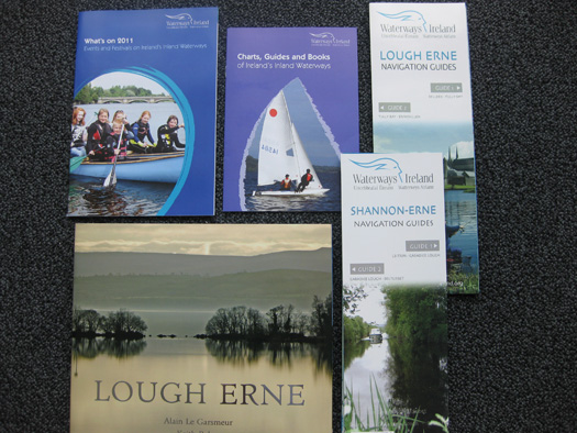
The new inland waterways publications
The Whats On 2011 is a free guide to all the events taking place along the waterway corridors in 2011. The Publications Catalogue (free) highlights the publications Waterways Ireland has for sale and for free with Navigation, History and Activity sections covering a wide range of interests. A photographic book for Lough Erne has just been published and is also for sale through Waterways Ireland.
All the publications are available from the Waterways Ireland webshop www.shopwaterwaysireland.org or from retailers, hospitality outlets and Tourist Information Centres along the navigations.


 Michael Murphy Schull Harbour Sailing Club (SHSC), Eric Coogan Heineken Ireland, Mark Murphy, Commodore SHSC, Jack Allen SHSC, Carmel O'Regan SHSC, Cornelious Ndlovu, Schull Harbour Hotel Operations Manager and Derval Murphy SHSC")


