


Displaying items by tag: Radar
Government is being asked to prioritise money for military radar equipment, including primary radar, RTE News reports.
The Minister for Defence is expected to recommend a major increase in defence spending at the Cabinet meeting later today, describing it as the "biggest Government decision on the Defence Forces in living memory ... and one of the biggest things I have ever done in politics".
Simon Coveney will update the Government on how to proceed with the recommendations made by the Commission on the Future of the Defence Forces.
The minister will ask colleagues to increase defence force spending from the current €1.1 billion annually to €1.5 billlion by 2028.
This is the recommendation for what was termed "level two ambition" in the commission's report.
The commission had called for this target to be achieved by 2030, but Mr Coveney is aiming to have the funding in place two years earlier.
More here on this spending programme.
Scientists Use Albatrosses To Spy On Illegal Fishing Fleets
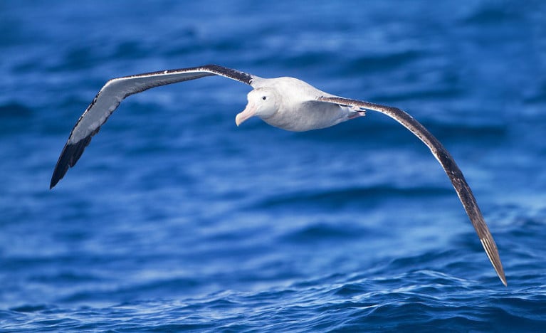
A team of scientists in France are ‘recruiting’ albatrosses to monitor fishing fleets in the ocean for illegal activity.
Smithsonian Magazine reports on the findings of a new study detailing efforts to tag the “sentinels of the sea” with tiny GPS trackers. These can detect short-range radar emissions from trawlers that may be acting suspiciously.
The team at CNRS, the French National Centre for Scientific Research, chose albatrosses to carry the devices as their extraordinary range at sea often exceeds that of aircraft and even some satellites in the most remote regions — and they tend to be attracted to fishing vessels as a food source.
In one six-month study of the Indian Ocean, researchers found that more than a quarter of fishing vessels detected at sea by the birds were not trackable on AIS — suggesting illegal fishing was afoot.
Smithsonian Magazine has much more on the story HERE.
New Radar System Could Improve Coastal Forecasts

A new radar system in Galway could help predict extreme weather events more accurately, The Irish Times reports.
Scientists at NUI Galway's Ryan Institute, in collaboration with the IBM Smarter Cities Technology Centre in Dublin, have installed the system on the shoreline in Galway Bay.
The system - the first of its kind in North Atlantic Europe - consists of two antennae, on Mutton Island and Spiddal, which scan the surface of the bay every half hour.
It then sends high-resolutions maps of surface currents and details of wave height and direction directly to the scientists' base at the NUIG campus.
The data is used, along with meteorological data, to develop models for forecasing marine conditions from tidal currents to storm surges - common on the challenging coastline around Galway Bay and the Aran Islands.
Moreover, the system is set to benefit the local community and beyond as the data, when completed, will be made freely available.
Silicon Republic says that the Galway Bay Coastal Observing System (GalCOS) could be used by sailors, fishermen and tourists to more accurately assess conditions in the area.
It could also be of use to local authorities in terms of providing details on the best time to release effluent while minimising environmental damage.
“This type of predictive modelling is critical to our Smarter Cities agenda," said IBM's Dr Lisa Amini, "and the findings can be widely applied to protect coastal cities and their environments."


