


Displaying items by tag: Celtic Interconnector
The Department of Transport has been advised that Next Geosolutions will perform shallow geotechnical surveys, pUXO ID surveys and KP5 Omega Loop surveys as part of the Celtic Interconnector Project cable route between the South-East Coast of Ireland and the coast of France.
The survey is expected to be completed over a 10-day period from this Wednesday 10 April, subject to weather and operational constraints.
Survey operations will be conducted within the cable corridor extending around 50m each side of the planned cable centreline.
The survey vessel NG Worker (callsign ICID) will carry out the survey works. Mariners are advised to provide a wide berth and navigate with caution in the area.
During survey operations, the vessel will keep a listening watch on VHF Channel 16 and will actively transmit an Automatic Identification System (AIS) signal. A listening watch will also be maintained on VTS VHF channels as appropriate.
The survey vessel shall broadcast daily, and at shorter intervals as may be required by passing traffic, the vessel position, operational information and planned operations for the next 24 hours. It is requested that fixed fishing gear within 1,000m of the route centreline be removed.
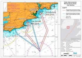
Coordinates and a map of the survey area as well as contact details can be found in Marine Notice No 13 of 2024 attached below.
Marine Notice: Cable Route Surveys for Celtic Interconnector
Next Geosolutions will perform a detailed marine, geotechnical and UXO survey on behalf of Nexans for CIDAC as part of the Celtic Interconnector project.
These surveys will follow the planned route of the Celtic Interconnector offshore power cable route between the South East Coast of Ireland and the coast of France.
Works will begin on Saturday 29 April (subject to weather and operational constraints) and will take approximately 169 days, of which 26 will be within Irish waters.
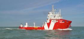
The surveys will be conducted by two vessels for both offshore and nearshore operations. The OSV Relume (callsign C6TR4) will be conducting the detailed marine, geotechnical and UXO survey works in the offshore areas and operations will be conducted on a 24-hour basis. Nearshore operations will be conducted by the vessel Deep Volans (callsign PETL) on a 12-hours basis.
Both vessels will display the relevant lights and shapes during periods of restricted manoeuvrability and adhere to COLREGS and all licensing requirements.
During operations both vessels will be running survey lines, and all other vessels operating in the area are requested to leave a wide berth. Both survey vessels will keep a listening watch on VHF Channel 16 and will actively transmit an AIS signal. A listening watch will also be maintained on VTS VHF channels as appropriate.
Maps and coordinates of the survey areas as well as contact details can be found in Marine Notice No 29 of 2023 attached below.
Planning Permission Granted for Celtic Interconnector Subsea Power Cable’s Landfall in Youghal
Planning permission has been granted for the East Cork landfall segment of the €1bn Celtic Interconnector power link between Ireland and France, according to RTÉ News.
The 500km subsea cable, a joint project of EirGrid and France’s Réseau de Transport d’Electricité, will be the first direct energy link between the two countries, as previously reported on Afloat.ie.
Following a public consultation three years ago, a site at Youghal was chosen for the landfall section at the Irish end.
Approval by An Bord Pleanála covers the cable plus associated infrastructure such as that for power conversion and connection to the national grid.
Pending the granting of a foreshore licence for offshore developments, as well as a marine licence from UK authorities for the cable route, it’s expected the Celtic Interconnector could be activated by 2026.
RTÉ News has more on the story HERE.

The State’s electricity transmission grid operator EirGrid has opened a two-month consultation on proposed south coast landfall and converter station locations for its electricity link between France and Ireland writes Lorna Siggins.
The Celtic Interconnector will be the first direct energy link between Ireland and France, running some 500 km under the sea from east Cork to the French north-west coast. A further 40 km of underground cable will be laid on land.
The project is being jointly developed by EirGrid and Réseau de Transport d'Électricité, the French electricity transmission system operator, with a target completion date of 2026.
Eirgrid is seeking the public’s reaction to a shortlist of three proposed landfall locations, and a shortlist of six proposed location zones for a converter station in east Cork.
The convertor station converts direct current electricity to alternating current and vice versa.
It has scheduled a series of public information days in east Cork between April 23rd and May 3rd (see list below).
The state-owned company says that the link will “put downward pressure” on the cost of electricity, while improving security of supply, providing a direct fibre optic telecommunications link, and facilitating further development of renewable sources.
A previous consultation round had confirmed east Cork as the most suitable location in Ireland for the project, which will have a capacity of 700 megawatts (MW).
Eirgrid says this capacity is enough to power 450,000 households, and the cable will allow both the import and export of electricity.
Eirgrid says that the proposed shortlisted landfall locations - Ballinwilling strand, Redbarn beach, and Claycastle beach – between Ballycotton and Youghal in east Cork were selected from a list of five.
The proposed shortlisted sites for the converter station are in Ballyadam, Leamlara, Knockraha, Pigeon Hill, Kilquane and Ballyvatta - all inland and north of Cobh - and these locations were selected from a list of 14 options, it says.
Eirgrid says that each location was assessed against five criteria; economic, technical, environmental, socioeconomic and deliverability.
EirGrid is encouraging communities and stakeholders to “share their feedback” on the proposed shortlists.
“The shortlists are provisional. Feedback from communities, local representatives, and other stakeholders will be critical to ensuring that we can assess each option fully and make informed decisions when confirming the shortlists,” Eirgrid spokeswoman Louise Glennon states.
Stakeholders, communities and members of the public are invited to respond by Monday, June 10th, by online, by email, by phone, in writing or by attending one of a number of information days in east Cork, as below:
Lisgoold Community Centre - Tuesday 23 April - 2pm – 8pm
Knockraha Community Centre - Wednesday 24 April - 2pm – 8 pm
Carrigtwohill Community Centre - Tuesday 30 April - 6pm – 9pm
Midleton Park Hotel - Wednesday 1 May - 2pm – 8pm
Cloyne Parochial Hall - Thursday 2 May - 6pm – 9pm
Walter Raleigh Hotel, Youghal - Friday 3 May - 2pm – 8pm
Marine Notice: Surveys Off South & South West Coasts
#MarineNotice - The survey vessel VOS Sweet (Callsign PCPE) is currently conducting offshore geotechnical and environmental survey operations associated with the proposed Celtic Interconnector on behalf of EirGrid.
The VOS Sweet was set to commence operations yesterday, Monday 18 June, and will operate on a 24-hour daily basis for approximately two weeks in two main corridors off East Cork to three landfall points: Ballinwilling Strand (Ballycotton Bay); Redbarn Beach and Claycastle Beach (Youghal Bay).
The survey is to collect geotechnical data utilising a Vibrocorer (VC) and Cone Penetration Test (CPT) spread and environmental (benthic) data utilising Grab Sampler spread. The survey will be conducted under Foreshore Licence FS006811. Common frequency VHF Channel 16 shall be used throughout the project.
Details of the route centreline co-ordinates as well as intended locations for the VC, CPT and benthic sampling are included in Marine Notice No 26 of 2018, a PDF of which is available to read or download HERE.
Meanwhile, Providence Resources is carrying out a site survey on its FEL 6/14 licence, called Newgrange, situated between the Southern Porcupine and Goban Spur Basins some 260km off the South West Coast.
The eight-day geophysical survey by the MV Kommandor (Callsign MCJO2), was scheduled to commence on Monday, is using dual-frequency side scan sonar, single-beam and multi‐beam echosounders, side scan sonar, sub‐bottom profilers and magnetometer.
Seabed (benthic) samples will also be taken using a box corer or grab as appropriate, and geotechnical sampling will be undertaken with a piston corer to a minimum target depth of 6m below the seabed.
In addition to the above, and to accurately determine potential future drilling hazards over the Newgrange location, the proposed survey will also include a high resolution 2D seismic which is not expected to exceed two days.
Survey operations will be conducted on a 24-hour basis. The MV Kommandor will be displaying shapes and lights prescribed in the International Rules for the Prevention of Collisions at Sea (COLREGS) Rule 27, to indicate that the survey vessel is restricted in its ability to manoeuvre. A listening watch will be maintained on VHF Channel 16, and the vessel will actively transmit an AIS signal.
Co-ordinates and a map of the expected working area are outlined in Marine Notice No 25 of 2018, a PDF of which is available to read or download HERE.
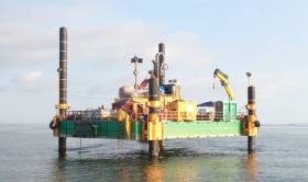
#MarineNotice - The Sandpiper jack-up platform is conducting nearshore geotechnical survey operations associated with the proposed Celtic Interconnector on behalf of EirGrid south of East Cork.
Similar to last autumn’s nearshore survey, the operations are taking place at three coastal locations – namely Ballinwilling Stran, Redbarn Beach and Claycastle Beach.
The Sandpiper (Callsign V3UA) will operate on a 24-hour daily basis commencing at the earliest from the Monday 14 May for approximately two weeks.
The Sandpiper is a non-self-propelled jack-up barge measuring 18.3m x 12.2m consisting of five Quadra pontoons and two duo pontoons with four 27m legs. The Sandpiper will be towed by the Trojan (Callsign EIEX6), a tug measuring 16m x 5m. Common frequency VHF Channel 16 shall be used throughout the project.
The survey will be conducted under Foreshore Licence FS006811, and is to collect geotechnical data utilising drilling spread only.
The nearshore survey activities will extend no more than 5km from the shoreline within a 500m area or corridor centred on the co-ordinates detailed in Marine Notice No 21 of 2018, a PDF of which is available to read or download HERE.
#MarineNotice - The survey vessel Kommandor Iona is conducting offshore survey operations associated with the proposed Celtic Interconnector, on behalf of EirGrid.
As with last month’s nearshore survey, the current works are in two main corridors to three landfall points off the South Coast of Ireland, namely Ballinwilling Strand, Redbarn Beach, Claycastle Beach.
The Kommandor Iona (Callsign: GAAK) was scheduled to begin operating on a 24-hour daily basis since this Tuesday (24 October) for approximately a week’s duration, collecting geophysical data utilising vessel mounted sensors and towed sonar extending up to 200m from the vessel.
The survey will be conducted under Foreshore Licence FS006722 in the deeper waters offshore from the Iona survey area limits.
Survey activities will extend no more than 35km from the shoreline within a 500m area or corridor centred on the co-ordinates listed in Marine Notice No 47 of 2017, a PDF of which is available to read or download HERE.
Those engaged in fishing are respectfully asked not to leave any static fishing equipment within a distance of 250 metres of the proposed survey route centre lines as detailed in the route position list, and skippers are advised to withdraw and keep beyond a safe distance (1 nautical mile) from survey vessels.
Marine Notice: Nearshore Survey Operations For ‘Celtic Interconnector’ Project
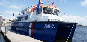
#MarineNotice - RMS Submarine Ltd advises that they will be conducting nearshore survey operations associated with the proposed Celtic Interconnector on behalf of EirGrid, at three coastal locations in Co Cork — namely Ballinwilling Strand, Redbarn Beach and Claycastle Beach.
The survey vessel Severn Guardian (Callsign 2FGL5), an 18m catamaran coastal survey vessel, will operate on a 12-hour daily basis, in daylight hours only, commencing from today (Thursday 28 September) for the next two weeks, approximately. Common frequency VHF Channel 16 shall be used throughout the project.
This survey is to collect geophysical data utilising vessel mounted sensors and a towed sonar which will extend up to 100m from the vessel. The survey will be conducted under Foreshore Licence FS006722, as per the foreshore licence map included in Marine Notice No 41 of 2017.
The nearshore survey activities will extend no more than 5km from the shoreline, within a 1km area or corridor centred at each of the three coastal locations. The remaining offshore sections will be surveyed by a separate vessel in the coming months, for which a separate notice to mariners will be issued.
Full details of co-ordinates of the work areas and more are included in Marine Notice No 41 of 2017, a PDF of which is available to read or download HERE.


 Michael Murphy Schull Harbour Sailing Club (SHSC), Eric Coogan Heineken Ireland, Mark Murphy, Commodore SHSC, Jack Allen SHSC, Carmel O'Regan SHSC, Cornelious Ndlovu, Schull Harbour Hotel Operations Manager and Derval Murphy SHSC")


