


Displaying items by tag: RV Celtic Voyager
Celebrating 20 Years: Marine Institute's RV Celtic Voyager
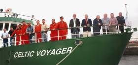
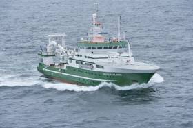
#MarineScience - Celebrating 20 years of service in July was the Marine Institute's RV Celtic Voyager, the second decade reached marked a significant milestone for Ireland's first purpose built research vessel.
The RV Celtic Voyager was built in the Netherlands and arrived in Ireland in July 1997 to replace the RV Lough Beltra (1978 – 1997) as part of the national strategy to build Ireland's capabilities in marine research. "Moving from the 21m Lough Beltra that had originally been a trawler, to a 31.4m research vessel was the beginning of a new era in marine science in Ireland, where the Institute was able to provide a purpose built platform that could operate further out in our ocean territory. This enabled high quality research and monitoring informing decisions about Ireland's marine resource into the future," explained Mick Gillooly, Director of Ocean Science and Information services, Marine Institute.
The multi-purpose facilities on the vessel has allowed scientists to gather information covering a wide range of ocean sciences, including sea bed mapping and learning more about the marine species and environmental conditions.
Specially fitted with scientific equipment in wet, dry and chemical laboratories, having the ability to carry more scientists and being able to spend more time at sea which increased the output of science in Ireland. The Celtic Voyager, in its first full year of operation reached 260 operational days and the scientific output also increased by 150 percent over the output of the Lough Beltra. The vessel also exceeded original expectations about its range by carrying surveys further south in the Bay of Biscay and as far west as the Rockall Trough.
In the last 20 years, the vessel has successfully completed over 4,800 science days and has sailed over 380,000 nautical miles in the course of 595 science surveys in that period; and has had a positive impact on many Irish marine scientists and crew member's careers at sea.
Ireland's marine territory is over 880,000 square kilometres in the Atlantic, Irish and Celtic Seas, and with the INFOMAR Programme, in partnership with the Geological Survey of Ireland, the Marine Institute is completing one of the largest civilian seabed mapping projects in the world. As part of the INFOMAR programme, the RV Celtic Voyager has been responsible for mapping 30,000 square km Ireland's coastal and inshore area since 2007. Using multi-beam technology on the vessel, scientists have collected data producing high resolution maps showing the shape and type of the seabed below at depths between 20 - ~100m.
"Significant discoveries have been made on the Voyager ranging from mapping over 200 shipwrecks around the coast of Ireland including the RMS Lusitania, RMS Leinster and the Kowloon Bridge to revealing new information about the seafloor. In 2007 the survey of Galway Bay revealed for the first time a detailed seafloor and geology of the bay, confirming the location of the Galway Bay Fault, demarking the limits of Galway's granite landscape running northwest to southeast, between Lettermullan/Gorumna Islands in west Connemara and the Aran Islands," explained Thomas Fury, manager of the advanced mapping team at the Marine Institute.
The RV Celtic Voyager has also played an essential role in fisheries scientific research in Ireland, in particular ground fish stocks such as haddock and whiting since its launch in 1997, as well as developing unique underwater television survey methods to gather information the Dublin Bay prawn (Nephrops norvegicus) since 2002. "The capabilities of the vessel has enabled marine scientists to work in conditions allowing them to better recognise significant changes in the abundance and distribution of a wide range of marine species and changes in the environment; and in turn provide sound scientific advice about information on stock size, exploitation status and catch of commercial species," explained Dr Paul Connolly, Fisheries Ecosystems and Advisory services, Marine Institute.
The RV Celtic Voyager has provided scientists the ability to a learn about the oceans dynamic ecological systems as well as ensuring that Ireland complies with national and EU regulations relating to the assessment of water quality and marine food safety. "Initially the vessel was used for looking at the levels of nutrients and pollutants in coastal waters that were either naturally caused by environmental conditions or introduced by humans such as agriculture run off, shipping and industrial activities," explained Jeff Fisher, Marine Environment and Food Safety Services, Marine Institute.
Surveys over the last decade have however increased the level of research to include the collection and assessment of phytoplankton as an indicator of the health of the ocean; as well as recovering samples of sediments and sea bed organisms for biological, chemical and geological analysis so as to assess at the quality and long term changes to sediment dwelling marine species. In more recent years scientists have also used the Voyager for the collection of water and sediment samples to monitor the impacts of climate change, ocean acidification and the introduction of micro plastics to the marine environment.
Dr Peter Heffernan, CEO of the Marine Institute congratulated the research vessel operations team, crew, scientists and researchers that have worked on the RV Celtic Voyager over the last 20 years, stating that "coastal research and offshore surveys involving fisheries research, environmental monitoring, seabed mapping, oceanographic work, buoy maintenance and student training all highlight the importance of having the best resources available, producing the best marine science in Ireland".
"In the Voyager's 20th year it is therefore important to recognise the contribution the vessel has made in providing marine scientists, researchers and its crew members, with many years of valued experience at sea, expanding and strengthening marine science in Ireland to help inform decisions affecting our ocean. This increase in activity also contributed to the expansion of Ireland's international role and profile in sustainable marine research, development, innovation and management."
Irish Scientists Discover Important Habitat of Elusive Beaked Whales
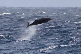
#MarineWildlife - A team of scientists on board the RV Celtic Voyager got more than they bargained for during a recent survey to understand the habitat use of elusive beaked whales.
That’s when they encountered four separate groups of breaching whales within a couple of hours near the Rockall Trough.
Very little is known about beaked whales as they are rarely encountered at sea and are shy around vessels. New species of the elusive marine mammals are being described as recently as last year.
In Ireland there are at least four species of beaked whales: Sowerby’s, True’s, Cuvier’s beaked whale and the northern bottlenose whale.
“We think that the groups encountered were either Sowerby’s or True’s beaked whale, possibly both, they are incredibly difficult to positively identify at sea,” said Dr Patricia Breen of NUI Galway, chief scientist on the survey.
“We know that they undertake huge dives to great depths of up to 2500m for an hour at a time. They feed mostly on squid but also deep sea fish.”
The recent survey was a collaborative study between NUI Galway, UCC, the Marine Institute, Centre for Marine and Renewable Energy, Marine Conservation Research and Washington State University.
The aim was to characterise beaked whale habitat using acoustic technology in a small study area, as the whales are more likely to be heard rather than seen.
As well as using a hydrophone to detect whale clicks the team also characterised the habitat by recording oceanographic information such as salinity, temperature and depth, as well as the fish and squid species in the area, their most likely food source.
Dr Ailbhe Kavanagh of UCC said: “We had seen a group of breaching beaked whales the previous day and upon finishing up our acoustic transects decided to return to the area we had sighted them in previously.
“While steaming through this area we encountered four groups of beaked whales, all breaching, and all groups of between two to four individuals.” Dr Breen added: “The amazing thing about this encounter was the high number of sightings in such a small and specific area. Less than 30km separated the first and last sightings.
“This highlights an area that, whilst small, is potentially of huge importance to beaked whales in Irish waters. We hope to investigate this area further in the future.” During the survey, the team caught many species of fish which live in the mesopelagic zone between 200m and 1000m deep.
“Recent studies have shown that some beaked whale species prey on both squid and mesopelagic fish,” said UCC’s Prof Emer Rogan. “It is likely that the fish species we were catching in our nets is the reason the whales are here, to feed.
“The information collected on this survey will we helpful in our efforts to learn more about the species and to ensure adequate protection of the habitat of beaked whales in Irish waters.”
The survey, which took place from Sunday 29 October to Monday 6 November, was funded through the national research vessels’ ship time programme. This research survey was carried out with the support of the Marine Institute, funded under the Marine Research Programme 2014-2020 by the Irish Government.
The Marine Institute’s ship time programme provides annual grant-aid to researchers to access ship-time to facilitate research projects/programmes and further develop the national potential to carry out world-class multidisciplinary marine research. For further information contact Dr Patricia Breen at [email protected].
The survey team included:
- Dr Patricia Breen, chief scientist, School of Geography, NUI Galway
- Professor Emer Rogan, School of Biological, Earth and Environmental Sciences, UCC
- Dr Enrico Pirotta, School of Mathematics, Washington State University
- Dr Oliver Boisseau, Marine Conservation Research
- Dr Ailbhe Kavanagh, Centre for Marine and Renewable Energy/ERI, UCC
- Ashley Bennison, School of Biological, Earth and Environmental Sciences, and Centre for Marine and Renewable Energy/ERI, UCC
- Morag Taite, School of Natural Sciences, NUI Galway
#MarineNotice - Mariners of the South Coast are advised that PSE Kinsale Energy will undertake a seabed mapping survey in the Kinsale Head and Seven Heads Gas Fields next week.
The survey is expected to begin on Monday 12 June and last for five or six days, subject to weather conditions.
The multi-beam mapping survey is to confirm the seabed status adjacent to subsea gas production infrastructure such as wellheads, manifolds and jacket/platform structures, collecting data for ongoing field maintenance operations and future planning.
The RV Celtic Voyager (Callsign EIQN) is scheduled to carry out the survey operations at specific locations to assess the status of the subsea infrastructure in relation to the adjacent seabed. A total of 15 multi-beam mapping locations are anticipated.
There will be a regular safety message broadcasting on VHF Channel 16 throughout the project. All vessels, particularly those engaged in fishing, are requested to give the RV Celtic
Voyager a wide berth and keep a sharp lookout in the relevant areas.
Full details of the survey area are included in Marine Notice No 24 of 2017, a PDF of which is available to read or download HERE.
First Of Six INFOMAR Seabed Surveys In 2017 Completed

#MarineScience - The Marine Institute’s RV Celtic Voyager returned to Cork Harbour last week after the first of six INFOMAR seabed mapping surveys planned for 2017.
The two-week seabed survey carried out its operations in the Celtic Sea south of the Waterford and Wexford coastlines.
The research team — involving geophysicists, geologists, marine biologists and data processors Kevin Sheehan, David O'Sullivan, Oisin McManus, Nicola O'Brien and Michael Arrigan — were tasked to accurately map the physical, chemical and biological features of the seabed area.
INFOMAR survey operations are conducted by a fleet of research vessels — including the RV Celtic Voyager, which is used for mapping seabed terrain in water depths between 20m and 100m.
The vessels are equipped with advanced mapping technologies including state-of-the-art acoustic sonars, geophysical instrumentation and ground-truthing capabilities, as well as geophysical equipment and precise satellite positioning.
“This helps to ensure data collection is of the highest possible quality across a wide range of water depths, conditions and environments, providing us with full coverage mapping of the shape and type of the seabed below,” says David O'Sullivan.
The INFOMAR survey around Ireland is one of the largest civilian seabed mapping projects in the world and aims to gather high resolution seabed data that contributes to the sustainable development of Ireland's marine resource.
As an island nation, Ireland is responsible for the sustainable management of its marine resources and it is important that accurate seabed maps are created to enable effective governance.
“Gathering up-to-date information about our ocean is cognisant of ensuring we have the best available science and knowledge to inform decisions affecting our ocean, particularly in relation to fisheries management and the development of ocean energy,” added O’Sullivan.
The INtegrated Mapping FOr the Sustainable Development of Ireland's MArine Resource (INFOMAR) programme is a joint venture between the Geological Survey of Ireland and the Marine Institute, funded by the Department of Communications, Climate Action and Environment.
Marine Institute Hosts Ocean Explorers at Oranmore
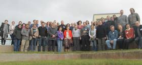
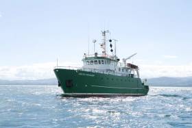
The Marine Institute held the second bi-annual research vessel users conference today at its headquarters in Oranmore, Galway to discuss the vast range of capabilities of both the RV Celtic Explorer and RV Celtic Voyager after their 2015 refits, as well as the use of the remotely operated vehicle, ROV Holland 1.
Director Mick Gillooly of Ocean Science and Information Services, Marine Institute, welcomed the attendance of over 70 marine scientists and researchers who will go to sea on the national research vessels this year. He said: “The demand for survey time on the national research vessels and the quality marine research being carried out across the country shows that Ireland’s scientists are answering the call to better understand our oceans.”
“At a time when we can all see the impacts of climate change, it’s more important than ever to carry out research at sea, including oceanography, fisheries, and environmental monitoring.”
The conference provided information about using high resolution multi-beam mapping, the capabilities of the ROV Holland 1 on surveys as well as key speaker’s experiences using the equipment.
Dr Florian Le Pape of the Dublin Institute for Advanced Studies (DIAS) spoke about the deployment of an Ocean Bottom Seismometer (OBS) network off the Irish shelf as far as the Rockall Trough. Dr Le Pape recently deployed 10 Broad Band OBSs from the RV Celtic Explorer as part of an innovative research program between DIAS, the Helmholtz Centre GFZ Potsdam, Germany and instruments provided by the Alfred Wegener Institute, Germany, which uses the noise from ocean waves to generate seismic images of the earth’s crust.
Over 70 marine scientists attended the Research Vessel Users Conference at the Marine Institute. Deep sea mud volcanoes off the gulf of Cadiz and the high resolution multi-beam mapping of World War 1 shipwrecks in the Irish Sea highlighted the advanced capabilities of the research vessels for deep sea exploration.
The workshop was organised by the Marine Institute’s research vessel operations team also highlighted the value of ship time. Mr Aodhan Fitzgerald, Research Vessel Operations Manager, spoke about the future vessel availability, the ship-time competition for 2017, and how to prepare a strong research survey proposal.
The Marine Institute’s ship-time programme will provide €3 million funding in 2016 supporting 256 research days onboard the national research vessels, RV Celtic Explorer and RV Celtic Voyager. The programme gives researchers access to the national research vessels, as well as the remotely operated submarine ROV Holland I to carry out surveys that further our understanding of the ocean, support policy and development, as well as providing essential training to young researchers and undergraduates.
The programme is part of a busy schedule of research vessel programmes that includes statutory fish stock assessment, environmental monitoring, and seabed mapping surveys in Irish Waters and across the Atlantic basin to Newfoundland.
You can follow the surveys of the research vessels on the blog http://scientistsatsea.blogspot.ie where scientist on-board the national research vessels blog about their research at sea
Research Vessel Users Workshop In April
#MarineScience - The research vessel operations team at the Marine Institute are hosting a workshop for research vessel users at the institute's Oranmore headquarters on Thursday 28 April.
The aim of the workshop is to give marine scientists across a range of disciplines the opportunity to discuss their research, and their experience on both the RV Celtic Explorer and RV Celtic Voyager, as well as using the ROV Holland 1.
It will also allow the research vessel operations team to highlight the capabilities of both research vessels post 2015 refits, and to gather feedback about how the service could be improved.
The meeting will commence at 9am and it is planned to finish at 6pm. There will be an opportunity to have a Q&A session around the talks and gather feedback from both the user and the service provider. Contact [email protected] with any queries.
The research vessel users workshop will be followed by a SMARTSkills day workshop also in Oranmore on Friday 29 April with training sessions on the following:
- MaxSea plotting software.
- Shipboard Computer System (SCS) training.
- IxBlue Echoes Sub Bottom Profiler training: practice and processing.
- CTD training.
- ADCP training.
- Kongsberg Multibeam operating system (SIS).
All of the above equipment will be available for hands-on training and there will also be a wide selection of other scientific equipment on display on the day. See the SMARTSkills website for further information. A draft agenda for the SMARTSkills training can be found HERE.
Busy Year Ahead for National Research Vessels, RV Celtic Explorer & RV Celtic Voyager
The Marine Institute’s Ship-Time Programme will fund 256 days at sea this year for marine science researchers to carry out surveys that will further our understanding of the ocean, support policy development, and provide essential training opportunities to young researchers and undergraduates. This is the tenth consecutive year of the Ship-Time Programme and it will provide €3m Euro in funding. The initiative provides access to the national research vessels, RV Celtic Explorer, and RV Celtic Voyager, as well a the ROV Holland I (remotely operated vehicle ). It represents just part of a very busy schedule of research vessel programmes that includes statutory fish stock assessment, environmental monitoring, and seabed mapping surveys.
Dr. Peter Heffernan, Marine Institute CEO, said the demand for ship-time and the quality of the applications was an indication of the standard of marine research being carried out in Ireland.
“Marine research in Ireland is being carried out to the highest standards and the strong demand for ship-time shows that Ireland’s scientists are answering the challenge to better understand our oceans”, said Dr. Heffernan. “At a time when we can all see the impacts of climate change, it’s more important than ever to carry out research at sea, including oceanography, fisheries, and environmental monitoring. We know that the ocean plays a key role in controlling the earth’s climate and we know that the microscopic plankton in the ocean produce half of the oxygen we breathe. The ocean is the life support system for the planet and therefore it is essential that we understand its impact on us, as well as our impacts on the ocean.”
The Ship-Time Programme funds surveys across three broad categories – research, policy support services and dedicated training programmes. The RV Celtic Voyager will be the platform for 15 Higher Education Institute led training programmes over 73 days throughout 2016. Last year over 390 students participated in training onboard the Celtic Voyager through this programme. The opportunity to spend time at sea on a working research vessel, planning, designing and carrying out research at sea is essential and invaluable experience for young scientists.
The RV Celtic Explorer will be the platform for eight research surveys under the Ship-time programme, while the RV Celtic Voyager will support ten research surveys under the initiative. Marine Institute scientists will lead seven of these surveys on both vessels in areas that support policy development and implementation.
Among the surveys taking place this year are a survey by the Dublin Institute for Advanced Studies monitoring part of the Irish shelf using ocean bottom seismometers in an innovative research program which uses the noise from ocean waves to generate seismic images of the earth’s crust (January 13-22); identifying the location of Sea Bass spawning areas (MI – March 16-29); exploring submarine canyon ecosystem services (NUI Galway June 1-20); and mapping and creating high resolution images of World War I ship wrecks (University of Ulster –September 3-9 ).
The provision of access to ship-time is identified as a key priority in Harnessing Our Ocean Wealth- An Integrated Marine Plan for Ireland. The Ship- time programme is funded under the Marine Research Programme 2014-2020 by the Irish Government. Applications for Ship Time funding are evaluated by a panel of 15 independent international experts (UK, European and US) and each application was reviewed by two or three evaluators.
New Call For Ship Time On Irish Research Vessels
#MarineScience - The Marine Institute has announced an additional call for funded ship time on the RV Celtic Explorer and the RV Celtic Voyager.
Applications are invited from research performing organisations including higher education institutions, public research bodies and industry to carry out ship-based research activity.
The areas of research may relate to: ecosystems approach to marine resource management; seabed processes and resources; climate/environmental change; renewable ocean energy; biodiscovery/biodiversity; novel marine technologies; and marine policy/legislati
Applications from early stage researchers, including PhD students or early post-doctoral researchers, are particularly encouraged to apply, to allow emerging marine scientists the opportunity to gain hands-on experience in undertaking ship-based research.
Applications will only be accepted for a limited number of days - one week in September 2014 on the RV Celtic Explorer, and up to three weeks with available dates in July, September, October and December 2014 on the RV Celtic Voyager.
The closing date for receipt of applications is 3pm on Thursday 17 April 2014. Applications must be submitted using the Research Vessel Operations' online Survey Planning System (SPS) and Research Information Management System (RIMS), which are available on www.marine.ie. (Please contact the Research Vessel Operations team at [email protected] to obtain a password for SPS.)
The Vessel Charter Guidelines 2014-1015 (Word doc 253KB) should be read carefully before submitting the Ship-Time Application Form.
Applicants may seek grant-aid to cover all or part of the vessel charter costs for research surveys. For information on eligibility for grant-aid and how to apply, read National Research Vessels 2014 Ship-Time Programme Grant Aid Guidelines (PDF 577KB).
Marine Notice: Hydrographic Survey Off South Coast
#MarineNotice - The latest Marine Notice from the Department of Transport, Tourism and Sport (DTTAS) advises that a hydrographic and geophysical survey operation will be undertaken by INFOMAR off the south coast of Ireland between 10 July and 7 August 2013.
The RV Celtic Voyager (Call sign EIQN) is expected to carry out the survey operations within an area bounded by co-ordinates detailed in Marine Notice No 26 of 2013, which is available to read or download HERE.
The vessel will be towing a magnetometer sensor with a single cable of up to 100m in length. The RV Celtic Voyager will display appropriate lights and markers and will be listening on VHF Channel 16 throughout the project.
All mariners are reminded of their responsibilities under the International Collision Regulations and are reminded of Marine Notice No 17 of 2007, which gives general advice in relation to the activities of vessels engaged in survey work for hydrographic, seismic, fishing research and underwater operations.
Marine Notice on Pipeline Survey in Celtic Sea

#NEWS UPDATE - The latest Marine Notice from the Department of Transport, Tourism and Sport (DTTAS) advises on a pipeline survey in the Celtic Sea next month.
PSE Kinsale Energy Limited will be commencing the survey of the 24" Gas Export Pipeline on 6 March 2012 using the Marine Institute vessel RV Celtic Voyager (call sign EIQN). The survey is expected to last 1 to 2 days, depending on weather conditions.
The survey will take place along the existing pipeline route in the Celtic Sea, between the shoreline at Inch Beach in Co Cork and gas platform 'Alpha'.
The RV Celtic Voyager will display appropriate lights and signals, and will be towing side scan sonar with cables of up to 200m long. A Radio Navigation Warning will be issued via the Irish Coast Guard (schedule Bravo, four times a day) prior to the vessel's arrival at the survey area. The vessel will also keep a listening watch on VHF Channel 16.
All vessels, particularly those engaged in fishing, are requested to give the RV Celtic Voyager and her towed equipment a wide berth and keep a sharp lookout in the relevant areas.
Further details for seafarers, including relevant co-ordinates, are included in Marine Notice No 7 of 2012, a PDF of which is available to read and download HERE.


