


#eastcoastports – Ireland's east and north coasts may lack the cruising glamour of the south and western seaboards, but W M Nixon suggests that the ICC's East & North Coast Sailing Directions points the way to an area with its own special charms. And he ponders a coastal mountain-measuring quandary in this blog first published in March 2014.
Now here's a thought. Could it be that Scrabo, the tower-topped hill which dominates the northern waters of Strangford Lough, is not as high as officially reckoned? Could it be that its recognised height of 538ft (which doesn't include the 125ft height of the tower itself) is a bit optimistic?
Such notions come from contemplating aspects of the new 12th Edition of the Irish Cruising Club's Sailing Directions for the East & North Coasts of Ireland, which is now on sale at £29.95 or €37.50. It's worth every cent, not just for those planning to cruise the area, but simply if you sail from any of the ports covered. And the interest lies not just in the essential information conveyed for safe navigation and pilotage along these many miles of varied coastline, but also in the implications of that information in a larger context.
As the ICC publishes two books with the most recent massive 13th edition of its best-selling South & West guide appearing last year, inevitably people will compare the two areas. And equally inevitably, the east coast can appear a rather humdrum sort of place by comparison with the lotus-eating charms of the south coast, and the spectacular glories of the west, while the north coast sometimes seems just too challenging to be contemplated at all. However, in one category the east and north coasts put the south and west coasts in the ha'penny place. The eastern and northern seaboards are absolutely tops in tides.
On the west and south coasts, apart from the Shannon Estuary and maybe Achill Sound and perhaps Cork Harbour entrance at Springs, tidal streams are relatively weak on the entire coastline going westabout between Hook Head in Wexford and Bloody Foreland in Donegal. And yes, I too have shot the tidal rapids at Lough Hyne, but that's a special case. Otherwise, it's useful to have the tide with you along the coast, and it's best to avoid wind-over-tide at major headlands. But generally, unless you've a long passage planned you can come and go at sociable hours for day sails rather than having your schedule dictated by tide.
Yet if you're voyaging that same journey from Ireland's southeast corner to the far northwestern extremity via the east and north coasts with the absolute shortest distance being 282 miles, the tidal streams are dictating your times of coming and going except between Skerries and Ardglass on the east coast, and west of Malin Head on the north. Elsewhere, it's conveyor belt coastline, and anyone sensible will go with the flow.
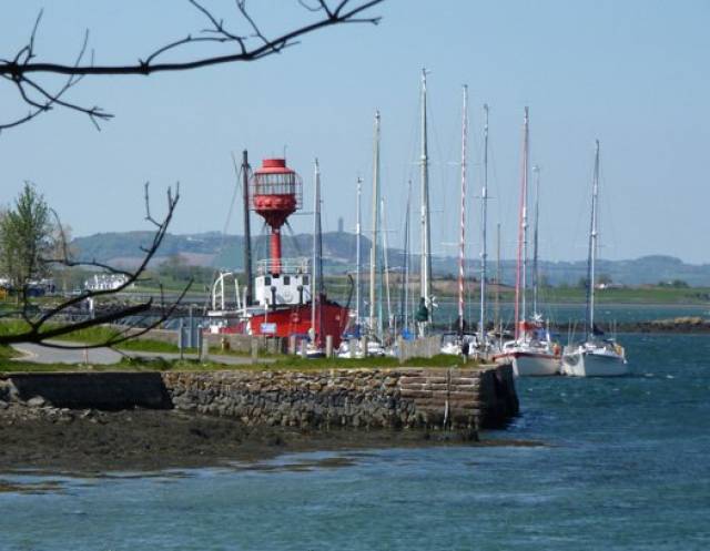
Carlingford Lough is one of several inlets on these coastlines whose narrow entrances have strong tides. The mediaeval little township of Carlingford has its own largely drying harbour (foreground), but the marina further along the shore is accessible at all states of tides, and has facilities on site. However, village waterfront hospitality resources are somewhat spread out, as the hospitable Carlingford Sailing Club (extreme right), with its own slipway and welcoming clubhouse, is at a significant distance from the marina. Photo courtesy ICC/Kevin Dwyer
In addition, where natural harbours and sheltered inlets exist, in a surprising number of cases on the east and north coasts the entrances are narrow, and pushing the tide to get through can be a serious challenge. This is the case in Mulroy Bay, Lough Foyle, Larne Lough, Strangford Lough and Carlingford Lough. But the great inlets of the west, particularly the magnificent rias of the southwest, are drowned river valleys which close in only gradually, resulting in much gentler tides.
Strangford Lough's entrance by contrast is totally tide-dominated, and many local cruising boats solve the problem simply by never leaving the place. But as a study of this new book (yet another extraordinary effort from the ICC's remarkable sailing directions team of Norman Kean and Geraldine Hennigan) successfully reveals, Strangford Lough is indeed a wonderful world unto itself, and you could happily cruise here for a week without feeling the need to venture into the dark unknown to seaward beyond The Narrows, where the tides hit 8 knots and more, and the whirlpool of the Routen Wheel waits to trap the unwary.
It's the business of the sea pushing in and out Strangford Lough twice a day (and generating electricity while it does so) which provokes the thought that maybe Scrabo is not as high as generally thought. The hill is simply known as Scrabo, which sounds like somewhere in Transylvania – it could be Dracula's summer residence - but apparently it means nothing more exciting than "cow pasture" in Gaelic. They were hardy cattle in them days, as it can be rugged enough on top, for Scrabo's location relative to the serene inner reaches of Strangford Lough emphasises its exposed nature.
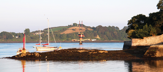
Strangford Narrows, with a smooth yet powerful stream, though it can be anything but smooth when it meets open water and an onshore wind. The tides in the Narrows provide so much guaranteed energy that they have been harnessed by this generator to provide sufficient electricity for a thousand homes. Photo: courtesy ICC
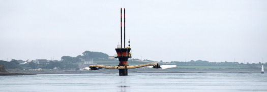
The Seagen tower with its turbines raised clear. Like this, it can be a hazard for sailboats passing too close. Currently, the scorecard reads: Seagen-1, Yacht Masts-0. Miraculously, no-one was hurt. Photo courtesy ICC.
But the point is that high water in those remote inner reaches and in Strangford Lough generally occurs a clear two and a half hours after high water in the Irish Sea. Thus down at the Narrows, the water may be still pouring into the lough, yet out in the Irish Sea the tide has peaked, the ebb is running north, and the sea level has been falling for a good two and a half hours by the time the final surge has reached the top, way up at the flat shore below Scrabo.
So it occurs to me that, could we but somehow measure by the most precise methods exactly from the centre of the earth, then mean sea level at Scrabo would always be less – maybe even a metre less – than on the ocean generally. And for all hills, whether it be Scrabo or Everest or whatever, the height above sea level is the gold standard. So the surface of the sea must curve over and above the curvature of the earth.
My ignorance of modern surveying methods being almost total, doubtless this idle speculation will bring down scorn, and we'll find that crude measures of sea level by observation at a local position have been long since superseded by more scientific techniques. Probably these days sea level has little enough to do with the level of the sea. But if you're someone who likes to muse on such things as the true height of Scrabo in the light of Strangford Lough's wayward tides, then you've the mind of a cruising person, and you'll find the new guide a delight, particularly if you reckon the east coast has been getting a raw deal in the perception stakes.
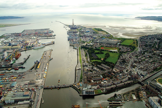
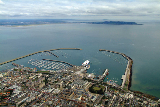
The Economic Corridor. Dublin Port looking seaward at a quiet period between ship movements, which currently run at 40 per day. Grand Canal basin is bottom right, while the ancient maritime community of Ringsend is just across the River Dodder. The Dodder's east bank, now lined with corporation flats, used to be a hive of activity with at least four boatyards on the foreshore. Poolbeg Y & BC marina is beside Roingsend. Photo courtesy ICC/Kevin Dwyer
That said, it has to be admitted that between Dublin and Belfast, the "East Coast Economic Corridor" may sound glamorous to business folk, but it can make it all seem rather workaday to the rest of us when sailing the nearby sea. Then too, the dictation of the tide in setting the times of your passage-making gives a sense that you're commuting along the coast, rather than cruising it. Finally, while there may be several handsome ranges of hills and mountain along both coastlines, only in certain areas is there significant indentation of the coastline to give that air of excited anticipation as to what might be round the next corner. By contrast in the south and west you've many variations on the sense of anticipation exemplified by the always uplifting experience of coming northwards through Dursey Sound and suddenly seeing the entire panorama of the Kerry mountains revealed in all their purple glory.
But living in such a state of constant excited anticipation would be damaging for anyone's health. The real business of life is making the best of the hand you've been dealt, and these days the east and north coast deal is much enhanced by greatly improved harbours and marinas. These make for much more convenient access to port towns, which in their turn provide a better hospitality package which adds greatly to the enjoyment of a day's sail along a coast which may have been looking very well indeed.
Not least of the factors in this is that, along the east coast at any rate, it rains less than on Ireland's other coastlines. Sometimes a lot less. And it's at its best when the wind is the Atlantic breeze, the westerly off the land. When "the wind is off the grass", as the crewmen in the Irish Lights vessel describe their ideal conditions for working at buoys and other navigation aids, then sailing Ireland's east coast is very pleasant indeed.
Although the east coast officially begins at Carnsore Point, the ICC Directions sensibly begin just round the corner at Kilmore Quay, whose transformation by Wexford County Council into a useful sailing/fishing harbour has greatly changed everyone's perception of the area. And just to show that the Saltee Islands can now be seen at the very least as an interesting day cruising destination from Kilmore itself, the book includes a useful photo of the fair weather anchorage on the southeast coast of the Great Saltee.
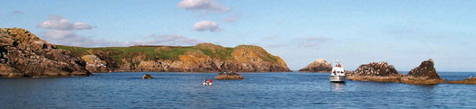
In times past, the Saltee Islands were seen by cruising folk as somewhere to get past as quickly as possible. But now that there's a fine little all-weather harbour and marina at Kilmore Quay, this photo of the fair weather anchorage off the southeast coast of the Great Saltee is of special interest. Photo courtesy ICC.
Heading up the east coast, the favoured first port of call tends to be Arklow, where developments in recent years have been an intriguing illustration of the way Ireland is administered. In any rational society, you'd have expected the Arklow Basin on the south side of the river – which has the benefit of having an exceptionally small tidal range – to be re-developed as a modern recreational harbour, a sort of Irish Honfleur.
But of course any attempts at this sensible line of action were stymied by inertia and entrenched interests, so the get-up-and-go section of Arklow society simply got on with things on the north side of the river. There, a marina has been developed in a new basin, and what amounts to a new township shows every sign of developing alongside it, while across the river the old basin slumbers on.
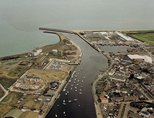
Arklow is home to an ancient seafaring tradition, manifested itoday in a vibrant locally-registered merchant fleet which operates internationally. The new harbour and waterfront development on the north bank of the river (left) proceeds crisply ahead while the old Arklow basin on the other side ponders it future. Photo courtesy ICC/Kevin Dwyer
Undoubtedly the most exciting development on the east coast in recent years has been the creation of an all-weather harbour at Greystones, within easy sailing distance of Dublin yet just far enough to provide a sense of achievement. And there's a certain extra satisfaction in enjoying your breakfast aboard a cruising boat in the new marina while the commuter-filled DART trains trundle past headed towards the city, yet beyond in the morning sun the Wicklow hills look more beautiful than ever.
"Good morning, Greystones, how are you?" Breakfast on a cruising boat never tastes better than when you're in the new Greystones Marina with the early sun on the Wicklow hills, and a DART train filled with commuters heads for Dublin. Photo courtesy ICC
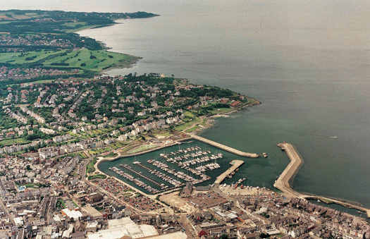
With the coastal developments of the last twenty to thirty years, the east and north coasts have now been reborn as sailing and cruising areas with the two main yacht harbours at Dun Laoghaire and Bangor, while there are now medium size marinas at Greystones, Poolbeg in Dublin, Howth, Malahide, Carlingford, Carrickfergus, Glenarm, Ballycastle, and Fahan on Lough Swilly.
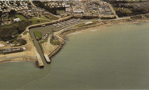
Additionally there are the key smaller facilities at Arklow, Warrenppoint, Ardglass. Portaferry, Belfast Harbour, Rathlin Island, the Bann Estuary, Derry/Londonderry and Rathmullan, while convenient landing pontoons have been installed at several other sites. Details on all these and much more can be found in the new ICC book, but anyone cruising the region develops fondness for some favourite spot, and as someone who has been cruising up and down these coasts for a while now, I have to say that the facility which has most transformed the cruising is surely the little marina at Ardglass, officially known as Phenick Cove.
Kingpin harbour – Dun Laoghaire before the new "library" was erected at amazing speed in the middle of the waterfront. Photo courtesy ICC/Kevin Dwyer
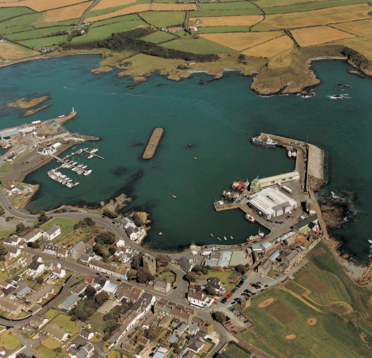
Ardglass. This little port has become one of the most useful of all, particularly for people who really do cruise. Photo courtesy ICC/Kevin Dwyer
It is just so conveniently located, you don't have to deviate at all from the direct course up and down Ireland's East Coast, and the welcome provided by marina manager Fred and his array of amiable animals is second to none. Quite how we managed before Ardglass marina was installed I don't know any more. But I think it involved far too many unnecessary nights at sea, whereas now you can have a convenient overnight in a quirky place where – if you're minded to eat ashore – you can ring the changes between one of the best Chinese restaurants on the coast, or else the golf club in the castle makes sailors more than welcome, and if you've had enough of the salty sea for a while, a very short taxi ride takes you into the utterly and very aromatically rural heart of the country and steaks at Curran's foodie pub.
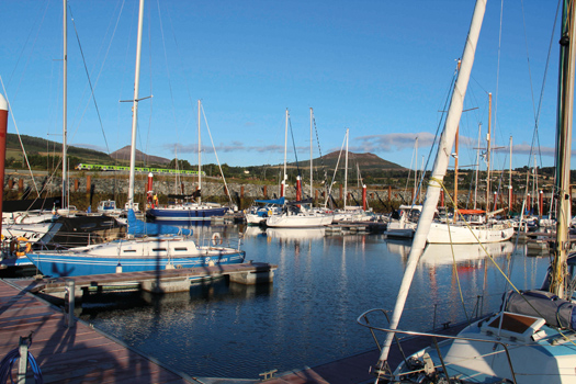
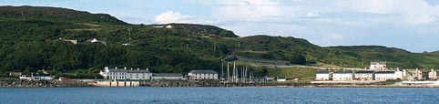
Bangor Bay's marina has settled in so well you could be forgiven for thinking the town was built around it. And you won't be surprised to learn that this part of North Down is known as the Gold Coast. Photo courtesy ICC/Kevin Dwyer
When these ICC Directions first appeared in book form in 1946, they covered only the east coast, and that only between Carnsore Point and the little harbour of Carnlough on the Antrim coast. In those days, there were few if any facilities for cruising boats beyond it on the Irish coast, so it was seen as the best jumping-off port for people headed for the more civilised cruising on Scotland's west coast.
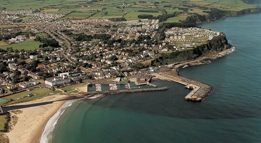
Ballycastle Harbour and marina required a king-size breakwater for full shelter, but its convenient location has been greatly beneficial for cruising the area. Photo courtesy ICC/Kevin Dwyer
Thirty years ago, the notion of Rathlin Island as a popular cruising destination would have seemed absurd, yet the provision of a harbour has brought about a welcome change, and in summer there are always at least several (and often many) cruising boats in port. Photo courtesy ICC.
So it's around Ireland's northeast corner that the changes have been most beneficial, with a proper harbour at Glenarm and –miracle of miracles – a real harbour at Ballycastle. It has had to be built as a really massive affair, for you're now on the rugged north coast, but it has opened things up to great benefit, as it's a short day sail from the Hebrides, the charms of Rathlin Island with its excellent little marina are just across the Sound, and with the pressure taken off to get to any old harbour with some short of shelter, you can explore the Antrim coast at your leisure. You come away convinced that the famous Carrick-a-Rede rope bridge looks even more spectacular when seen from sea, yet equally convinced by Dr Johnson's famous comment that while the Giant's Causeway may be worth seeing, it's not worth going to see.
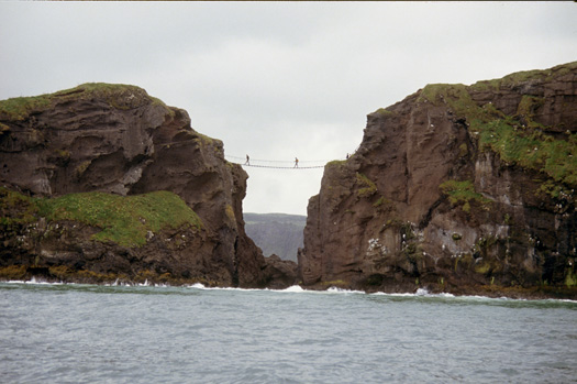
The north Antrim coast's famous Carrick-a-Rede rope bridge is best seen from a cruising boat. Photo: W M Nixon
Further along the north coast, there's excitement at Portrush as a 200 berth marina is planned for this key port. For anyone interested in harbour construction, it will be a fascinating project, for although Portrush is eastward of the most exposed point of all at Malin Head, it still manages to have truly ferocious sea conditions during winter storms. So the proposed new breakwater will have to be on mega-scale, but from a cruising point of view the provision of secure marina berths here will add an entirely new dimension. Portrush has direct rail connection with the rest of Ireland, and it provides the best departure port if you want to make a quick passage to the Outer Hebrides. A course from Portrush shaped to leave Skerryvore to starboard will take you neatly to Castlebay in Barra while leaving the inconvenient tides and turbulent waters of Islay well clear to the east, and the rough water north of Malin well away to the west.
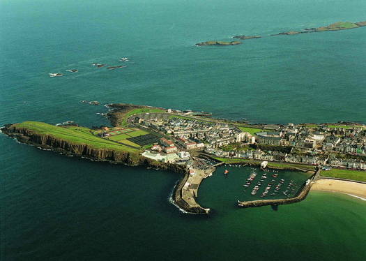
Portrush as it is today. A plan for a 200 berth marina will necessitate an ambitious extension and reinforcement of the main breakwater. Photo courtesy ICC/Kevin Dwyer
But for anyone cruising on towards north Donegal, those demanding waters off Malin Head are part of the challenge, and plumb in the middle of them is storm-racked Inishtrahull. Amazingly, in the long distant past this little island supported several families, but these days its deserted state would make you wonder at the ICC book's assertion that there's quite a decent anchorage at Portmore on the island's hyper-rocky northern coast. So just to show that there is indeed an anchorage here, the book features a photo of Portmore with a fine cruising yacht serenely in the midst of it.
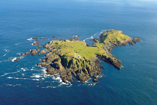
Remote Inishtrahull, most northerly part of Ireland. Yet there is an anchorage here..............
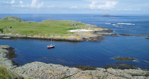
.....and the ICC book has the photo to prove it. Photos courtesy ICC/Kevin Dwyer/Ed Wheeler
West of Malin, the majestic north coast of Donegal includes the entrances to many inlets, the largest being Lough Swilly which is about the size of the Solent. The main sailing base is at the sandy creek at Fahan on the east shore where the provision of a marina brought expectations of proper well-planned shoreside supporting development to take the raw look off the place, but disappointingly it hasn't happened yet. We can only hope that the success of local sailor Sean McCarter as a skipper in the current Clipper Round the World Race will inspire the Fahan area to finish the job.
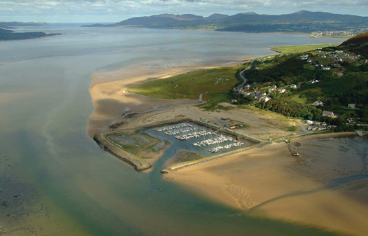
A job that really ought to be finished properly. The marina at Fahan on the east shore of Lough Swilly in Donegal is badly in need of appropriate shoreside development. Photo courtesy ICC/Kevin Dwyer
Further west, and its pure Atlantic, but relieved by remote and secure inlets. Nevertheless it's difficult to grasp that the secluded and forest-sheltered anchorage at lovely Ards on Sheephaven is only a very few miles from the storm-tossed rocks of Tory Island, but such is the case. At Camusmore on Tory, the tiny harbour seems to be hurricane-proof, for although it was in the most violently-assaulted of all areas on Ireland's west coast during the thirteen storms of the past rough winter, surprisingly Tory is not among the harbours listed for government largesse in the current tranche of funding for urgent repairs.
This snug tree-sheltered anchorage at Ards on Sheephaven does not accord with the popular perceptions of the rugged nature of North Donegal, yet here we see a lone cruising boat enjoying its gentle charms. Photo courtesy ICC/Kevin Dwyer
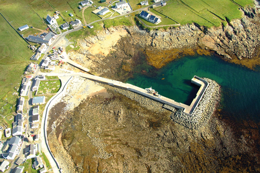
It's bullet-proof, it's hurricane proof – it seems there was no need for the little nugget of a harbour at Camusmore on Tory Island to apply for emergency funding for any urgent repairs despite the winter-long assault by at least thirteen different storms. Photo: Courtesy ICC/Kevin Dwyer
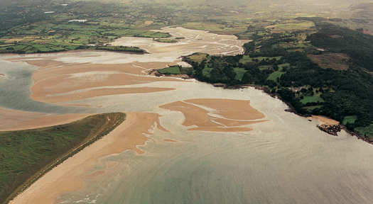
But Tory Island's nearest mainland quay at Magheraroarty is down for repair funding, and away to the far southeast at the crowded little harbour of Courtown in Wexford, they've a harbour which is down for more than €1 million in repairs expenditure. Courtown is a difficult one, a narrow little river port where life is a continuing struggle to keep the sand at bay, and yet stop the quay walls from being undermined. When you see what they had to do at Tory and Ballycastle to keep their harbours in place, you can't help but wonder if the sum allocated to Courtown is anything like enough, but at least official interest is being shown.
Courtown on Wexford's east coast is one of the harbours earmarked for urgent repair expenditure under this week's government scheme. Phot courtesy ICC/Kevin Dwyer
Many years ago, Paddy Barry set out to cruise round Ireland in his Galway Hooker St Patrick without using any anchorages recommended in the Sailing Directions by his fellow members of the ICC. It was just possible back then, and he overnighted at sixteen different places which were "unexplored". It would be virtually impossible to do that today, but even so it's entertaining to see if some favourite little places, some unknown quirky spots, have somehow slipped under the ICC radar.
Has anyone overnighted there? The pool inside Chapel Island invites anchoring.
I can think of two, but have to admit that while I've seen them both, and seen boats in them, I've never taken a boat into either myself. One is a curious glaciated pool that is found behind Chapel Island in the southeast corner of Strangford Lough. At high water there's little enough shelter in the sound inside Chapel Island. But at low water, the classic Strangford Lough seabed emerges on either side, more than a metre high, while in the little pool you're lying in more than three metres. A couple of times I've seen a boat or two anchored in the area at high water while we've been hastening past entering or leaving the lough. But whether or not anyone has stayed on for the sweet entrapment at lower water I don't know, but would dearly like to hear from anyone who has.
The other secret place is one mile east of Rosslare ferry port. When the port was being almost completely redeveloped years ago, it seems they made this little harbour to accommodate all the local small boats which were being evicted from their long-established if often uncomfortable berths on the edges of the ferryport. It may well be that officially this harbour doesn't exist at all. As it is, there's a notice at it which states that the only people who are entitled to berth their boats there are persons normally resident in the electoral district of St Helen's, which is the area of Rosslare Ferryport. But for anyone cruising this tricky coast in a small boat, knowledge of the existence of this secret little harbour could even be a lifesaver when all other options have been closed off.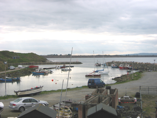
The secret little harbour one mile east of Rosslare doesn't claim to be a glamour spot, but it provides a very useful facility for local boat-owners. Photo: W M Nixon
It says everything about the completeness of the ICC books that these two little exceptions are the only unmentioned places I've been able to think of in the new East & North Coast book, and both are undoubtedly special cases. So once again Norman Kean and Geraldine Hennigan have created a masterpiece of it kind, a book which not only adds to safety when cruising our different regions, but greatly adds to the enjoyment of studying every aspect of our coastlines.
The latest and 12th Edition of the ICC's East & North Coast books continues a fine tradition of service to the cruising community which goes back to the first edition, a set of Roneo sheets produced in 1930. The new book is €37.50 (£29.95).
This blog was first published in March 2014.


 at last weekend’s RIYC 195th Anniversary Classics Regatta in Dublin Bay, sailing under a suit of original cotton sails. Designed by G L Watson of Glasgow and built by John Hilditch of Carrickfergus, Peggy Bawn’s exceptional authenticity has been recognised with several international awards")


