


Displaying items by tag: ESB
High Water Levels on Shannon Hit Rowing Clubs Hard
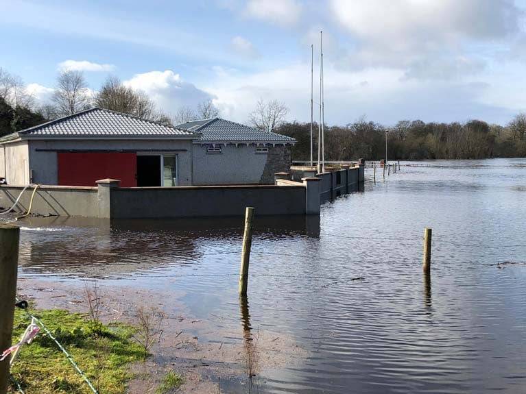
Rowing clubs along the Shannon have been badly affected by high water levels. Carrick on Shannon and Athlone have both been hit, while Castleconnell is flooded. This came despite pumping. The gym equipment had been moved out and the boats are stored higher up the bank.
This ESB at Ardnacrusha stated: “Due to heavy rainfall in the catchment we will be increasing discharge from Parteen Weir. You are being notified that water is about to be discharged above 325 m3/sec. This will result in flooding of roads, land and may affect property. You are advised to be aware of increased flows in the river as a result of this water discharge. Further increases in discharge may be required. Approx. 400 m3/sec will be discharged.”
ESB Backs Rowing Festival at Inniscarra
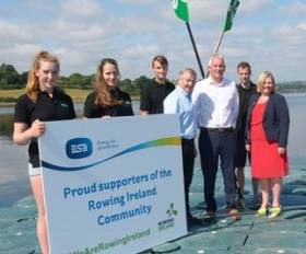
#Rowing: ESB has teamed up with Rowing Ireland to support a series of prestigious rowing regattas on Inniscarra Reservoir this month. The Coupe de la Jeunesse, from July 27th to 29th, will attract talented young rowers from 13 countries across Europe. Up to 750 rowers and their support teams are expected in the Cork area for this high-profile event. The event is open to rowers who are 18 years or under. The Festival of Rowing programme also includes the Irish Rowing Championships taking place this weekend, July 13th to 15th, as well as the Home International Regatta which takes place on July 21st.
Rowing Ireland CEO Michelle Carpenter said: “We are delighted with the ESB support of our exciting Festival of Rowing which commences this weekend with the biggest ever Irish Rowing Championships. The relationship between the ESB and Rowing Ireland has been pivotal and we are delighted to have them support our celebration of Irish and International here at our High Performance home in Inniscarra.”
Frank Barry, Plant Manager at ESB’s Lee Stations said: “In what is a milestone month for the rowing community, ESB is delighted to support Rowing Ireland in their hosting of these three upcoming regattas on Inniscarra Reservoir. This support builds on our long-standing relationship with the rowing community. In 2011, ESB entered a 25 year lease with Rowing Ireland which has facilitated development of world-class infrastructure at the National Rowing Centre. As such, the facilities at Farran provide a fitting backdrop as we welcome the international athletes for the 2018 Coupe de la Jeunesse in particular. On behalf of ESB, I wish all participants the very best of luck in these prestigious events.”
Cork County Council and Fáilte Ireland are also providing support for the events.
Warning When Accessing Flooded Areas In Boats & Flotation Devices
Waterways Ireland continues to advise caution while extensive flooding continues across all navigations. Advice has also been issued by ESB networks in relation to available clearance under overhead or sunken electricity cables.
ESB Networks is warning members of the public and emergency services to be vigilant when moving around flooded areas in boats and other flotation vehicles.
The electricity network is designed to have ample clearance for access and egress during normal conditions. However, when areas are flooded, this clearance level may be affected.
The electricity network is live and should not be approached. Electricity wires are dangerous even at close proximity and where clearance is compromised, you should not pass under them.
If you see any sagging electricity wires or wires submerged in water, please do not steer your boat over these. Do not use oars or anything else to lift or move electricity wires. Please report any poor clearance issues immediately to ESB Network at 1850 372 999.
ESB Networks is currently assessing the electricity network in flooded areas to assess damage and identify safety issues.
ESB International Gathering Sound Data off Clare Coast
The Department of Transport, Tourism and Sport has been advised that ESB International have deployed two C-POD hydrophone units, for the purpose of gathering sound data, off the West coast of Ireland, at Killard, Co. Clare.
The C-POD hydrophone units are deployed at the following co-ordinates:
Location Latitude (WGS84) Longitude (WGS84)
52° 45.051' N 009° 32.455' W
52° 44.652' N 009° 43.074' W
For more details download the full marine notice below.
Shannon Sluice Gates Opened to Allay Flood Concerns
#INLAND WATERWAYS - Sluice gates have been opened at locks and dams along the River Shannon due to flooding concerns, The Irish Times reports.
The ESB confirmed that water levels in the upper Shannon had been rising significantly since September, and were just below those recorded prior to the flooding in Carrick-on-Shannon two years ago.
However the flooding threat has abated this week, with levels in Lough Allen dropping by around 300cm, although the situation is still subject to amounts of rainfall in the coming days as the Shannon drains slowly.
Levels in Lough Ree have also stabilised after rising throughout October.
The ESB continues to discharge from the Ardnacrusha power plant, while Waterways Ireland has commenced dredging at Meelick in Co Galway.
The Irish Times has more on the story HERE.
New Fisheries Partnership for the River Shannon

The new group will comprise representatives from both bodies as well as Inland Fisheries Ireland, and will be independently chaired by former Shannon Fisheries Board CEO Eamon Cusack.
The plan is for anglers, fishery authorities and stakeholders to come together to assist in the management of the River Shannon.
At the group's launch in Athlone recently, Cusack said the partnership was working toward ensuring a sustainable yield of fish.
Dublin Port: As You’ve Never Seen It Before
On board the open-topped yellow tour-boat RIB, an audio commentary firstly informs you about the M.V. Cill Airne, built nearby in the old Liffey Dockyard, nearly fifty year ago. Discover why she was one of the last riveted built vessels in Europe, her days as liner-tender and the rich and famous who threaded her decks.
Heading downstream the former lightship Kittiwake is berthed opposite the O2 Arena. She was one of the last lightships to serve in Irish waters at the South Rock station off Co. Down. In complete contrast a ferris-wheel revolves in the background but no sooner the boat slips under the East-Link Toll-Lift bridge which opened in 1984.
On the other side of the bridge a small non-descript looking grey-hulled motorboat lies at anchor, on her bow is painted the figure 11. So what's the story here!...here's a glue: 'Don't pay the ferry man until you get to the other side!...
Past Poolbeg Marina, giant blue-gantries cranes of the Marine Terminal Ltd (MTL) are busy unloading from Karin Schepers, a containership previously reported on Afloat.ie. Look out for the ports 'graffiti', the work of crews who make their mark by painting the name of their ship and also the mural of the late Ronnie Drew of The Dubliners.
Opposite this terminal is the ports largest basin, Alexandra Basin, named after Queen Alexandra. Subject to port security, the tour may include entering the basin should there be a particular vessel of note.This also allows for views of the dock-gates of the Dublin Graving Dock, one of only three large ship-repair facilities on the island of Ireland. Neighbouring the graving dock is where the Liffey Dockyard once stood.
Before the tour passes the towering twin stacks of the former ESB Poolbeg electricity power station is tucked away Pigeon Harbour. Learn more about its hotel conveniently sited beside where packet-ships regularly plied, essentially the ferryport of its day. Its modern-day counterpart faces opposite on the north quays where up to 17 sailings daily operate on the Irish Sea.
Marvel at the length of the impressive Great South Wall, why was it called 'Great' and why was it built?... What can be revealed is that Captain William Bligh of "Mutiny of the Bounty" fame was a major figure in the project, when the wall was completed in 1795.
The commentary has many more fascinating facts, figures and the occasional anecdote told with typical Dublin wit. So if you live within 80km (50-mile) radius of the capital, then the chances that the shirt you wear, the breakfast cereal you ate and the car you drive, most likely came through Dublin Port as almost 75% of goods serve this hinterland.
More on Dublin Bay here
- Dublin Port
- River Lee
- Sea Safari Tours
- Poolbeg Marina
- River Liffey
- Ports and Shipping News
- ESB
- Karin Schepers
- EastLink bridge
- Dublin Port & River Liffey Tours
- Dublin ferryport
- MV Cill Airne
- ESB Poolbeg powerstation
- Alexandra Basin Dublin Port
- Liffey Dockyard
- Dublin Bay boat operator
- Marine Terminal Ltd
- MTL
Angling in Ireland: What's Your View?
A recent letter to The Irish Times highlights some stark difference between Europe and Ireland as a top angling destination.
Reader Kevin McDonnell from Co Cork recounts a fly-fishing trip in Norway, praising "pristine rivers accessed through open and clean farmyards ... where netting for salmon is illegal, where hydro-electric schemes allow fish to pass and provide a minimum level of water flow, even in dry conditions, to allow for the safe passage of migrating fish."
In contrast, a more recent visit to the ESB salmon fishery at Inniscarra Dam on the River Lee revealed "endless rubbish, discarded fishing line, 20m of large-diameter ESB cable by the river’s edge, bonfires, ragwort and forestry so dense that nothing grows at ground level."
McDonnell also noted the low level of water being released from the "almost full" reservoir above, and what appeared to be high levels of phosphate contamination.
Is Ireland as an angling destination "a joke" as this angler says, or is this just one side of the story? Have your say in the comments below.


 for the new skiff and builder Patsy Whelan Jnr.")


 with his exuberant crew as they celebrate being overall winners of Howth Wave 2024")
