Menu

Ireland's sailing, boating & maritime magazine

Inland afloat headers


Displaying items by tag: Wild Atlantic Way

Tourism is now worth €3billion per year on the Wild Atlantic Way, an increase of 59% on 2013, according to Fáilte Ireland.

This growth has contributed to the creation of an additional 35,000 jobs, with tourism now supporting 121,000 jobs across the region, the tourism body says.

While Fáílte Ireland says it does not yet have a detailed breakdown which might illustrate the impact on watersports and marine leisure, one of its testimonials for its report comes from Jim and Maria Kennedy of Atlantic Sea Kayaking in West Cork.

Kennedy says he was proud to be one of the Wild Atlantic Way’s first ambassadors, and says their company has benefited “with much increased international visitor numbers”.

A report published by Fáílte Ireland and released at Meitheal, its two-day trade event underway in Kerry, says that nearly 2 million more visitors visited the Wild Atlantic Way in 2023 compared with 2013.

Speaking at Meitheal, Minister for Tourism, Culture, Arts, Gaeltacht, Sport and Media Catherine Martin said the 2,500-kilometre route “along our rugged Atlantic coast…is now a household name and cements Ireland’s reputation as a must-visit tourism destination”

“ I commend Fáilte Ireland and Tourism Ireland on their work in driving this success over the last 10 years,”she said.

Fáílte Ireland chief executive Paul Kelly said: “We are proud to mark the 10th anniversary of the Wild Atlantic Way at Meitheal this year and reflect on a brand that has had a truly transformative impact on the economy of the west coast.”

“Tourism is now worth €3billion per year to the region. This growth has contributed to the creation of an additional 35,000 jobs in local communities, with tourism now supporting 121,000 jobs across the region. Domestically, the Wild Atlantic Way is our most popular region with 51% of all domestic tourism revenue being generated there,”Kelly said.

“When we compare this internationally, based on the most recent data available, we see that inbound travel to Ireland grew by 45% between 2013 and 2019, well above the Northern European average of 25%. And the Wild Atlantic Way was a key contributor to this success with overseas visitor bednights in the region growing by 60% across this period,” he said.

Tourism Ireland chief executive Alice Mansergh said her organisation “ loved making the Wild Atlantic Way famous overseas".

“ We captured behind-the-scenes interviews with the stars of Normal People, Banshees of Inisherin and Star Wars, as they filmed along the route, inspiring screen tourism,” she said.

“ Tourism Ireland has co-produced 22 food and travel focused TV shows highlighting the Wild Atlantic Way, reaching 450 million in viewership around the world, with hosts like Donal Skehan and John Torode,” Mansergh said.

“ Bringing journalists to experience the scenery, heritage and culture along the route has led to coverage in publications like The Guardian, The New York Times and National Geographic, adding up over the years to an ‘equivalent advertising value’ of over 1 billion euros,” she said.

“As we mark 10 years, we’ll be showcasing what the Wild Atlantic Way has to offer across 14 markets around the world, through a mix of TV, digital and social channels,” she said.

“ We invite everyone to get involved in this special birthday, sharing their favourite photos of the route to wish ‘Happy 10th Birthday to Ireland’s #WildAtlanticWay’,” she added.

Published in Aquatic Tourism
Tagged under

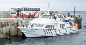
In scenic west Co. Kerry the Valentia Island car-ferry started today with the resumption of the seasonal service which runs from April to October, writes Jehan Ashmore.

The ferry service which is near Cahirciveen on the Iveragh Peninsula, connects Renard on the mainland to Knightstown on the east of Valentia Island, part of the Wild Atlantic Way.

Operating the route is Valentia Island Ferries with their God Mets On III that plies on the five-minute route which is based on a continuous shuttle service throughout the day.

Domestic and tourist vehicles using the 43m double-ended ferry include cars, MPV's, motorhomes, campers, mini-buses, cars with caravans and trailers, commercial vans, motorbikes. In addition to conveying bicyles and foot passengers.

The veteran vessel built in 1963 had originally served in The Netherlands across the River Maas until replaced by a bridge. Since 1996 the ferry has operated to Valentia which is approximately 11kms in length and 3 kms wide.

The 95 gross tonnage ferry runs the first and final crossings each day from Knightstown.

It was here in 1858 when HMS Agamemnon landed the first transatlantic telegraph cable, linking Knightstown to Hearts Content Newfoundland, Canada.

To the west of Knightstown at Cromwell Point is Valentia Island Lighthouse, the most westerly harbour light on the island of Ireland. It is a tourist attraction and is open to bookings.

On the middle of the island is Geokaun Mountain and cliffs, the highest point of the Island with stunning panoramic views of Kerry which have been designated as a Discovery Point on the Wild Atlantic Way.

A road runs along about two-thirds of the island from Knightstown to a bridge on the south of the island. The bridge which opened in 1970 connects to Portmagee on the mainland.

Prior to the completion of the bridge, a passenger/cargo ran between Reenard Point and Knightstown.

Published in Ferry

A new study of the Wild Atlantic Way recommends development of “niche marine tourism” options along the coastal route.

Visitors taking part in marine-related activities tend to spend more and stay longer than average, and so regional authorities and tourism agencies should provide supports for these “offerings”, the study says.

It also recommends improving infrastructure, and identifying and developing “the unique experiences and draws” that “entice visitors to stay longer”.

The research was conducted for the Moses project, an EU multinational research initiative involving eight partners representing the five member states of the Atlantic area.

Funded through the EU Interreg programme, the project aims to further the EU’s Blue Growth strategy in five “focus maritime areas” with “the potential to accelerate learning across Europe”.

"Visitors taking part in marine-related activities tend to spend more and stay longer than average"

The study says policies aimed at extending the tourist season should be developed, and environmental pressures and damages should be identified and reduced “early”.

It recommends reducing the emphasis on day trips - where tourist money is often diverted from local residents.

It says efforts should be made to ensure employment is local, and cultural and traditional experiences are supported.

It recommends encouraging ICT uptake in sustainable tourism trail usage.

It also says tourist operators should be encouraged to shorten their supply chains by using locally sourced inputs.

It also says these operators should also be encouraged to “consider their waste management strategies and use of alternative materials”.

A team at NUI Galway’s Socio-Economic Marine Research Unit conducted the research between 2018 and 2020.

The Northern & Western Regional Assembly (NWRA) was also a partner in the two-year study.

Published in Aquatic Tourism

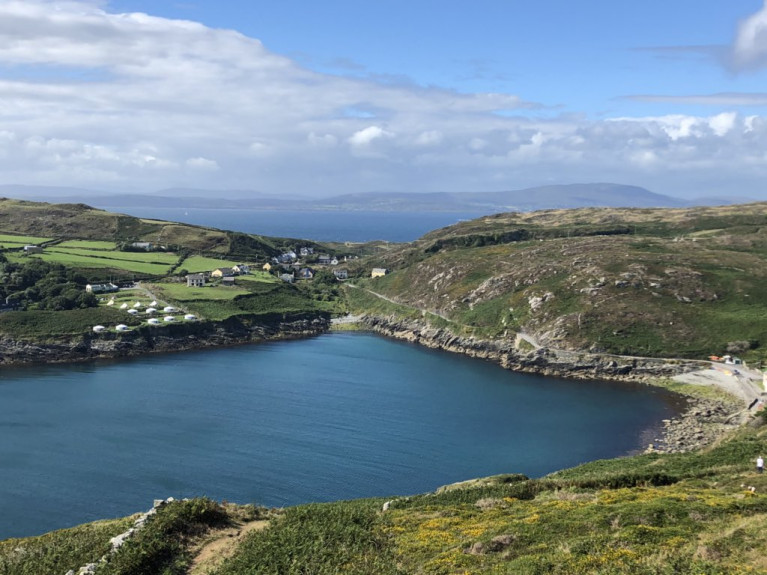
Islands along the Wild Atlantic Way not surprisingly are among seven in a list of islands within Irish and UK waters which draw attention as there’s something about crossing the sea that makes a holiday feel proper.

As BreakingNews adds staycations are all the rage right now for obvious reasons, but cars and trains lack the intrepid glamour of boats and planes, and when you visit an island it feels like you’ve entered a new and exciting ecosystem.

Island hopping begins at home. Here are some awesome islets that can help save your holiday, on both sides of the Irish Sea…

...where Cape Clear off Cork in the south west, the Aran Islands in Galway Bay and Claire Island further to north along the Wild Altantic Way in Co. Mayo proudly feature among the seven islands.

So take a snapshot read of these islands and beyond to those in UK waters by clicking here.

Published in Island News

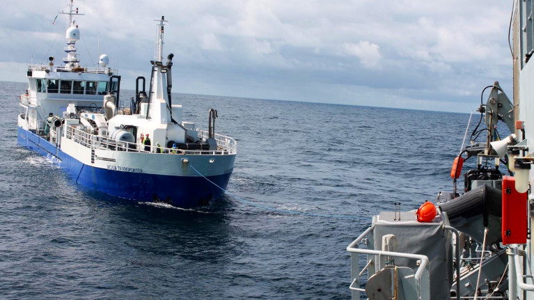
Off Ireland's west coast a potential ecological disaster was averted when the Naval Service intervened to prevent a cargoship laden with oil from crashing against rocks.

Aqua Transporter, reports Irish Examiner, was carrying 32,000 cubic tonnes of fuel and two cubic tonnes of lubricating oil, had lost power and was drifting towards rocks. If it had collided, its contents would have caused a major pollution incident along the Wild Atlantic Way.

The Coast Guard contacted the Naval Service after receiving a request for help from the ship's Norwegian skipper, who reported he had lost engine power and was drifting. Fortunately, LÉ Niamh was on routine patrol just a few miles away.

The navy ship, under the captaincy of Lieutenant Commander Claire Murphy, responded to the early morning emergency request on Tuesday to help the cargo ship and its crew of six. It was drifting a few miles off Slyne Head, near Galway.

More about the incident by clicking here. 

Afloat.ie adds the Norwegian flagged 60m fish-carrier in recent days departed Rathmullen, Co. Donegal is now docked at the Port of Galway in the Dun Aengus Dock. 

Published in Navy

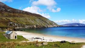
Keem Bay on Achill Island has made the grade among the 50 best beaches in the world, according to a top travel website.

And as The Irish Post reports, the Co Mayo coastal beauty spot was ranked among the best even of that number, placing just outside the top 10 of Big 7 Travel’s selection.

Keeping company with the gorgeous turquoise waters of the Adriatic and eastern Mediterranean, the West Indies and other breathtaking tropical paradises, we think that’s good going for the Wild Atlantic Way.

Published in Coastal Notes

#ferries - A new service has been launched by Bus Éireann in partnership with Doolin Ferry Company for people to explore the Wild Atlantic Way, reports GalwayDaily.

The new Route 350 which operates from Galway offers a combined bus and ferry service exploring the sights of the Wild Atlantic Way with tour of the Cliffs of Moher or a day ticket out to Inis Oírr.

Customers can avail of two combined ticket options which each cost €38.50 for both the bus ticket and either a 1-hour ferry tour of the Cliffs or a trip out to Inis Oírr.

The bus route also offers a regular service from Galway, through Doolin and on to Ennis that runs up to six times daily.

Bus Éireann describe the new route as a “great value day trip option to visit Ireland’s most popular tours destinations along the very popular Wild Atlantic Way.”

To read more and where to buy tickets, click here. 

Published in Ferry

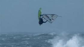
Force 10 winds forecast for this weekend will attract eight of the world’s more fearless windsurfers to Ireland’s Atlantic coast for a competition three years in the making.

As BreakingNews.ie reports, the precise date and venue for the Red Bull Storm Chase along the Wild Atlantic Way have not yet been decided, being influenced by where the squalls currently tracking towards Ireland ahead of two major storm systems will make landfall.

But if conditions prove optimal, the brave boarders will take to the big waves — judged on the size of their high-flying jumps, their artistry in the air and their overall style amid winds in excess of 100kmh.

BreakingNews.ie has more on the story HERE.

Published in Surfing

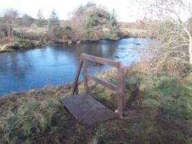
#Angling - A new project on the River Easkey in Co Sligo which has improved and developed angling access to the wild salmon river between Sligo and Ballina has now been completed.

The project, which was delivered by River Easkey Angling Association, received support from Inland Fisheries Ireland (IFI) via the National Strategy for Angling Development.

Structures such as footbridges, stiles, and ladders were installed along the river, which is located on the Wild Atlantic Way, while walkway routes on the banks of the salmon and trout fishery were also improved.

The work took place upstream of the famous Workhouse Bridge as part of the second phase of this project which initially involved similar works downstream of the bridge last year.

In total, the project has delivered eight new access points to angling, 13 footbridges ranging from three to four metres in length, and five kilometres of improved trail access.

Sean Canney, Minister of State for responsibility for inland fisheries, said on Wednesday (23 January): “I welcome the continuing efforts of Inland Fisheries Ireland in delivering under the National Strategy for Angling Development in partnership and collaboration with local angling clubs and community groups nationwide.

“Inland Fisheries Ireland committed €23,500 in total to support the Easkey project with €10,000 awarded in 2017 and a further €13,500 granted in 2018.

“I also want to congratulate the River Easkey Angling Association on its excellent development ethos. They are a progressive group that helpfully operates an open policy for holders of a State Salmon License with season and day tickets available for access,” he added.

Suzanne Campion, head of business development at IFI, said: “The River Easkey Angling Association has done fantastic work in developing this area as an angling destination. While completing this project and working closely with our project officers, they have given due diligence to everything from financial and environmental governance to biosecurity considerations ensuring the conservation and protection of this wonderful resource.”

Alan Spencer, assistant secretary of the River Easkey Angling Association, expressed the club’s thanks to Inland Fisheries Ireland’s staff for all their help and support during the project, as well as gratitude to landowners who permitted the club and its contractor access to the river through their property.

Published in Angling

#CoastalNotes - Eugene Garrihy a Clare businessman writes The Irish Examiner has criticised the results of a new survey that has labelled Doolin a “litter blackspot."

Mr Garrihy, father of Dancing with the Stars celeb and Fair City actor Aoibheann Garrihy, operates Doolin2Aran Ferries and yesterday described the results of the Irish Business Against Litter litter survey as “grossly unfair”.

This summer, Mr Garrihy’s firm has invested €3m in its operations with the commissioning of the 200-seater Star of Doolin on the Doolin-Aran Islands route.

For further reading click here.

Published in Coastal Notes
Page 1 of 4

General Information on using Waterways Ireland inland navigations

Safety on the Water

All users of the navigations are strongly recommended to make themselves aware of safety on the water for whatever activity they are involved in and to read the advice offered by the various governing bodies and by:

The Dept. of Transport, Ireland: www.gov.ie/transport and The Maritime and Coastguard Agency, UK, The RNLI – Water Safety Ireland for information in terms of drowning prevention and water safety.

Registration of Vessels

All vessels using the Shannon Navigation, which includes the Shannon-Erne Waterways and the Erne System must be registered with Waterways Ireland. Only open undecked boats with an engine of 15 horsepower or less on the Shannon Navigation, and vessels of 10 horsepower or less on the Erne System, are exempt. Registration is free of charge.

Craft registration should be completed online at: https://www.waterwaysireland.org/online-services/craft-registration

Permits for use of the Grand and Royal Canals and the Barrow Navigation

All vessels using the Grand and Royal Canals and the Barrow Navigation must display appropriate valid Permit(s) i.e A Combined Mooring and Passage Permit (€126) and if not intending to move every five days, an Extended Mooring Permit (€152).

Permit applications should be completed online at: https://www.waterwaysireland.org/online-services/canal-permits

Passage on the Royal and Grand Canals – Dublin Area

For boat passage through the locks east of Lock 12 into / out of Dublin on either the Royal or Grand Canals, Masters are requested to contact the Waterways Ireland Eastern Regional Office (M-F 9.30am-4.30pm) on tel: +353(0)1 868 0148 or email [email protected] prior to making passage in order to plan the necessary lock-keeping assistance arrangements.

On the Grand Canal a minimum of two days notice prior to the planned passage should be given, masters should note that with the exception of pre-arranged events, a maximum of 2 boats per day will be taken through the locks, travelling either east or west.

Movements in or out of the city will be organised by prior arrangement to take place as a single movement in one day. Boaters will be facilitated to travel the system if their passage is considered to be safe by Waterways Ireland and they have the valid permit(s) for mooring and passage.

Newcomen Lifting Bridge

On the Royal Canal two weeks’ notice of bridge passage (Newcomen Lifting Bridge) is required for the pre-set lift date, and lock assistance will then also be arranged. A minimum of 2 boats is required for a bridge lift to go ahead.

Waterways Ireland Eastern Regional Office (Tel: +353(0)1 868 0148 or [email protected] ) is the point of contact for the bridge lift.

A maximum number of boats passing will be implemented to keep to the times given above for the planned lifts (16 for the Sat / Sun lifts & 8 for the weekday lifts). Priority will be given on a first come first served basis.

On day of lift, boaters and passengers must follow guidance from Waterways Ireland staff about sequence of passage under bridge & through Lock 1, and must remain within signed and designated areas.

Events Held on the Waterways

All organised events taking place on the waterways must have the prior approval of Waterways Ireland. This is a twelve week process and application forms must be accompanied with the appropriate insurance, signed indemnity and risk assessment. The application should be completed on the Waterways Ireland events page at :

https://www.waterwaysireland.org/online-services/event-approval

Time Limits on Mooring in Public Harbours

On the Shannon Navigation and the Shannon-Erne Waterway craft may berth in public harbours for five consecutive days or a total of seven days in any one month.

On the Erne System, revised Bye Laws state that: No master or owner shall permit a vessel, boat or any floating or sunken object to remain moored at or in the vicinity of any public mooring, including mooring at any other public mooring within 3 kilometres of that location, for more than 3 consecutive days and shall not moor at that same mooring or any other public mooring within 3 kilometres of that location within the following 3 consecutive days without prior permission by an authorised official.

Winter Mooring on the Shannon Navigation and Shannon Erne Waterway

Winter mooring may be availed of by owners during the period 1 Nov to 31 Mar by prior arrangement and payment of a charge of €63.50 per craft. Craft not availing of Winter Mooring must continue to comply with the “5 Day Rule”. Winter Mooring applications should be completed online at : https://www.waterwaysireland.org/online-services/winter-moorings-booking

Owners should be aware that electricity supply and water supply to public moorings is disconnected for the winter months. This is to protect against frost damage, to reduce running costs and to minimise maintenance requirements during the winter months.

Vessel owners are advised that advance purchasing of electricity on the power bollards leading up to the disconnection date should be minimal. Electricity credit existing on the bollards will not be recoverable after the winter decommissioning date. Both services will be reinstated prior to the commencement of the next boating season.

Smart Cards

Waterways Ireland smart cards are used to operate locks on the Shannon Erne Waterway, to access the service blocks, to use the pump-outs along the navigations, to avail of electrical power at Waterways Ireland jetties.

Berthing in Public Harbours

Masters are reminded of the following:

  • Equip their vessel with mooring lines of appropriate length and strength and only secure their craft to mooring bollards and cleats provided for this purpose.
  • Ensure the available berth is suitable to the length of your vessel, do not overhang the mooring especially on finger moorings on floating pontoon moorings.
  • Ensure mooring lines, electric cables and fresh water hoses do not create a trip hazard on public jetties for others users.
  • Carry sufficient fenders to prevent damage to your own vessel, other vessels and WI property.
  • Allow sufficient space between your vessel and the vessel ahead /astern (c.1m) for fire safety purposes and /or to recover somebody from the water.
  • Do not berth more than two vessels side by side and ensure there is safe access/egress at all times between vessels and onto the harbour itself.
  • Do not berth in such a way to prevent use of harbour safety ladders, slipways or pump-outs.
  • Do not allow the bow of your vessel to overhang the walkway of a floating mooring thus creating a hazard for others with an overhanging anchor or bow fendering.
  • Animals are not allowed to be loose or stray at any time.
  • Harbour and jetty infrastructure such as railings, power pedestals, fresh water taps, electric light poles, safety bollards, ladders etc are not designed for the purpose of mooring craft , they will not bear the strain of a vessel and will be damaged.
  • At Carrybridge on the Erne System, Masters of vessels are not permitted to use stern on mooring. Masters of vessels must use the mooring fingers for mooring of vessels and for embarkation / disembarkation from vessels.

Passenger Vessel Berths

Masters of vessels should not berth on passenger vessel berths where it is indicated that an arrival is imminent. Passenger vessels plying the navigations generally only occupy the berths to embark and disembark passengers and rarely remain on the berths for extended periods or overnight.

Lock Lead-in Jetties

Lead-in jetties adjacent to the upstream and downstream gates at lock chambers are solely for the purpose of craft waiting to use the lock and should not be used for long term berthing.

Vessel Wake

Vessel wake, that is, the wave generated by the passage of the boat through the water, can sometimes be large, powerful and destructive depending on the hull shape and engine power of the vessel. This wake can be detrimental to other users of the navigation when it strikes their craft or inundates the shoreline or riverbank. Masters are requested to frequently look behind and check the effect of their wake / wash particularly when passing moored vessels, on entering harbours and approaching jetties and to be aware of people pursuing other activities such as fishing on the riverbank.

Speed Restriction

A vessel or boat shall not be navigated on the Shannon Navigation at a speed in excess of 5 kph when within 200 metres of a bridge, quay, jetty or wharf, when in a harbour or canal or when passing within 100 metres of a moored vessel or boat.

Vessels navigating the Shannon-Erne Waterway should observe the general 5 kph speed limit which applies along the waterway. This is necessary in order to prevent damage to the banks caused by excessive wash from vessels.

Vessels navigating the Erne System should observe the statutory 5kt / 6mph / 10kph speed limit areas.

A craft on the Royal and Grand canals shall not be navigated at a speed in excess of 6km per hour.

A craft on the Barrow Navigation shall not be navigated at a speed in excess of 11km per hour except as necessary for safe navigation in conditions of fast flow.

Bank Erosion

Narrow sections of all the navigations are particularly prone to bank erosion due to the large wash generated by some craft. Masters are requested to be vigilant and to slow down to a speed sufficient to maintain steerage when they observe the wash of their craft inundating the river banks.

Unusual Waterborne Activity

Unusual waterborne vessels may be encountered from time to time, such as, hovercraft or amphibious aircraft / seaplanes. Masters of such craft are reminded to apply the normal “Rule of the Road” when they meet conventional craft on the water and to allow extra room to manoeuvre in the interest of safety.

Sailing Activity

Mariners will encounter large numbers of sailing dinghies from late June to August in the vicinity of Lough Derg, Lough Ree and Lower Lough Erne. Sailing courses are marked by yellow buoys to suit weather conditions on the day. Vessels should proceed at slow speed and with due caution and observe the rules of navigation when passing these fleets, as many of the participants are junior sailors under training.

Rowing

Mariners should expect to meet canoes and vessels under oars on any part of the navigations, but more so in the vicinity of Athlone, Carrick-on-Shannon, Coleraine, Enniskillen and Limerick. Masters are reminded to proceed at slow speed and especially to reduce their wash to a minimum when passing these craft as they can be easily upset and swamped due to their very low freeboard and always be prepared to give way in any given traffic situation.

Canoeing

Canoeing is an adventure sport and participants are strongly recommended to seek the advice of the sport’s governing bodies i.e Canoeing Ireland and the Canoe Association of Northern Ireland, before venturing onto the navigations.

Persons in charge of canoes are reminded of the inherent danger to these craft associated with operating close to weirs, sluice gates, locks and other infrastructure particularly when rivers are in flood and large volumes of water are moving through the navigations due to general flood conditions or very heavy localised precipitation e.g. turbulent and broken water, stopper waves. Shooting weirs is prohibited without prior permission of Waterways Ireland.

Canoeists should check with lockkeepers prior entering a lock to ensure passage is done in a safe manner. Portage is required at all unmanned locks.

Canoe Trail Network – "Blueways"

Masters of powered craft are reminded that a canoe trail network is being developed across all navigations and to expect more organised canoeing along these trails necessitating slow speed and minimum wash when encountering canoeists, rowing boats etc

Rockingham and Drummans Island Canals – Lough Key

It is expected that work on Rockingham and Drummans Island Canals on Lough Key will be completed in 2021. Access to these canals will be for non-powered craft only, eg canoes, kayaks, rowing boats.

Fast Powerboats and Personal Watercraft (Jet Skis)

Masters of Fast Powerboats (speed greater than 17kts) and Personal Watercraft (i.e.Jet Skis) are reminded of the inherent dangers associated with high speed on the water and especially in the confines of small bays and narrow sections of the navigations. Keeping a proper look-out, making early alterations to course and /or reducing speed will avoid conflict with slower vessels using the navigation. Personal Watercraft are not permitted to be used on the canals.

Towing Waterskiers, Wakeboarders, Doughnuts etc

Masters of vessels engaged in any of these activities are reminded of the manoeuvring constraints imposed upon their vessel by the tow and of the added responsibilities that they have to the person(s) being towed. These activities should be conducted in areas which are clear of conflicting traffic. It is highly recommended that a person additional to the master be carried to act as a “look-out” to keep the tow under observation at all times.

Prohibition on Swimming

Swimming in the navigable channel, particularly at bridges, is dangerous and is prohibited due to the risk of being run over by a vessel underway in the navigation.

Age Restrictions on operating of powered craft

In the Republic of Ireland, Statutory Instrument 921 of 2005 provides the legal requirements regarding the minimum age for operating of powered craft. The Statutory Instrument contains the following requirements:

- The master or owner of a personal watercraft or a fast power craft shall take all reasonable steps to ensure that a person who has not attained the age of 16 years does not operate or control the craft

- The master or owner of a pleasure craft powered by an engine with a rating of more than 5 horse power or 3.7 kilowatts shall take all reasonable steps to ensure that a person who has not attained the age of 12 years does not operate or control the craft.

Lifejackets and Personal Flotation Devices (PFDs)

Lifejackets and PFD’s are the single most important items of personal protective equipment to be used on a vessel and should be worn especially when the vessel is being manoeuvred such as entering / departing a lock, anchoring, coming alongside or departing a jetty or quayside.

In the Republic of Ireland, Statutory Instrument 921 of 2005 provides the legal requirements regarding the wearing of Personal Flotation Devices. The Statutory Instrument contains the following requirements:

- The master or owner of a pleasure craft (other than a personal watercraft) shall ensure, that there are, at all times on board the craft, sufficient suitable personal flotation devices for each person on board.

- A person on a pleasure craft (other than a personal watercraft) of less than 7 metres length overall shall wear a suitable personal flotation device while on board an open craft or while on the deck of decked craft, other than when the craft is made fast to the shore or at anchor.

- The master or owner of a pleasure craft (other than a personal watercraft) shall take all reasonable steps to ensure that a person who has not attained the age of 16 years complies with paragraph above.

- The master or owner of a pleasure craft (other than a personal watercraft), shall take all reasonable steps to ensure that a person who has not attained the age of 16 years wears a suitable personal flotation device while on board an open craft or while on the deck of a decked craft other than when it is made fast to the shore or at anchor.

- The master or owner of a pleasure craft (other than a personal watercraft) shall take all reasonable steps to ensure that a person wears a suitable personal flotation device, at all times while – (a) being towed by the craft, (b) on board a vessel or object of any kind which is being towed by the craft.

Further information is available at: http://www.irishstatutebook.ie/eli/2005/si/921/made/en/print

Firing Range Danger Area – Lough Ree

The attention of mariners is drawn to the Irish Defence Forces Firing Range situated in the vicinity of buoys No’s 2 and 3, on Lough Ree on the Shannon Navigation. This range is used regularly for live firing exercises, throughout the year, all boats and vessels should stay clear of the area marked with yellow buoys showing a yellow "X" topmark and displaying the word "Danger".

Shannon Navigation, Portumna Swing Bridge Tolls

No attempt should be made by Masters’ of vessels to pay the bridge toll while making way through the bridge opening. Payment will only be taken by the Collector from Masters when they are secured alongside the jetties north and south of the bridge.

Navigating from Killaloe to Limerick on the Shannon Navigation

The navigation from Killaloe to Limerick involves passage through Ardnacrusha locks, the associated headrace and tailrace and the Abbey River into Limerick City. Careful passage planning is required to undertake this voyage. Considerations include: lock passage at Ardnacrusha, water flow in the navigation, airdraft under bridges on Abbey River in Limerick, state of tide in Limerick

Users are advised to contact the ESB Ardnacrusha hydroelectric power station (00353 (0)87 9970131) 48 hours in advance of commencing their journey to book passage through the locks at Ardnacrusha. It is NOT advised to undertake a voyage if more than one turbine is operating (20MW), due to the increased velocity of flow in the navigation channel, which can be dangerous. To ascertain automatically in real time how many turbines are running, users can phone +353 (0)87 6477229.

For safety reasons the ESB has advised that only powered craft with a capacity in excess of 5 knots are allowed to enter Ardnacrusha Headrace and Tailrace Canals.

Passage through Sarsfield Lock should be booked on +353-87-7972998, on the day prior to travel and it should be noted also that transit is not possible two hours either side of low water.

A Hydrographic survey in 2020 of the navigation channel revealed that the approach from Shannon Bridge to Sarsfield Lock and the Dock area has silted up. Masters of vessels and water users are advised to navigate to the Lock from Shannon bridge on a rising tide one or two hours before High Tide.

Lower Bann Navigation

The attention of all users is drawn to the “Users Code for the Lower Bann”, in particular to that section covering “Flow in the River” outlining the dangers for users both on the banks and in the navigation, associated with high flow rates when the river is in spate. Canoeists should consult and carry a copy of the “Lower Bann Canoe Trail” guide issued by the Canoe Association of Northern Ireland. Users should also contact the DfI Rivers Coleraine, who is responsible for regulating the flow rates on the river, for advisory information on the flow rates to be expected on any given day.

DfI Rivers Coleraine. Tel: 0044 28 7034 2357 Email: [email protected]

Lower Bann Navigation – Newferry – No wake zone

A No Wake Zone exists on the Lower Bann Navigation at Newferry. Masters of vessels are requested to proceed at a slow speed and create no wake while passing the jetties and slipways at Newferry.

Overhead Power Lines (OHPL) and Air draft

All Masters must be aware of the dangers associated with overhead power lines, in particular sailing vessels and workboats with cranes or large air drafts. Voyage planning is a necessity in order to identify the location of overhead lines crossing the navigation.

Overhead power line heights on the River Shannon are maintained at 12.6metres (40 feet) from Normal Summer level for that section of navigation, masters of vessels with a large air draft should proceed with caution and make additional allowances when water levels are high.

If a vessel or its equipment comes into contact with an OHPL the operator should NOT attempt to move the vessel or equipment. The conductor may still be alive or re-energise automatically. Maintain a safe distance and prevent third parties from approaching due to risk of arcing. Contact the emergency services for assistance.

Anglers are also reminded that a minimum ground distance of 30 metres should be maintained from overhead power lines when using a rod and line.

Submarine Cables and Pipes

Masters of vessels are reminded not to anchor their vessels in the vicinity of submarine cables or pipes in case they foul their anchor or damage the cables or pipes. Look to the river banks for signage indicating their presence.

Water Levels - Precautions

Low Water Levels:

When water levels fall below normal summer levels masters should be aware of:

Navigation

To reduce the risk of grounding masters should navigate on or near the centreline of the channel, avoid short cutting in dog-legged channels and navigating too close to navigation markers.

Proceeding at a slow speed will also reduce “squat” effect i.e. where the vessel tends to sit lower in the water as a consequence of higher speed.

Slipways

Reduced slipway length available under the water surface and the possibility of launching trailers dropping off the end of the concrete apron.

More slipway surface susceptible to weed growth requiring care while engaged in launching boats, from slipping and sliding on the slope. Note also that launching vehicles may not be able to get sufficient traction on the slipway once the craft is launched to get up the incline.

Bank Erosion

Very dry riverbanks are more susceptible to erosion from vessel wash.

Lock Share

Maximising on the number of vessels in a lock will ensure that the total volume of water moving downstream is decreased. Lock cycles should be used for vessels travelling each way.

High Water Levels:

When water levels rise above normal summer level masters should be aware of:

Navigation

Navigation marks will have reduced height above the water level or may disappear underwater altogether making the navigable channel difficult to discern.

In narrow sections of the navigations water levels will tend to rise more quickly than in main streams and air draft at bridges will likewise be reduced.

There will also be increased flow rates particularly in the vicinity of navigation infrastructure such as bridges, weirs, locks etc where extra care in manoeuvring vessels will be required.

Harbours and Jetties

Due care is required in harbours and at slipways when levels are at or near the same level as the harbour walkways' as the edge will be difficult to discern especially in reduced light conditions. It is advised that Personal Flotation Devices be worn if tending to craft in a harbour in these conditions.

Slipways

Slipways should only be used for the purpose of launching and recovering of water craft or other objects from the water. Before using a slipway it should be examined to ensure that the surface has sufficient traction/grip for the intended purpose such as launching a craft from a trailer using a vehicle, that there is sufficient depth of water on the slipway to float the craft off the trailer before the concrete apron ends and that the wheels of the trailer do not drop off the edge of the slipway. That life-saving appliances are available in the vicinity, that the vehicle is roadworthy and capable of coping with the weight of the trailer and boat on the incline. It is recommended that slipway operations are conducted by two persons.

Caution to be Used in Reliance upon Aids to Navigation

The aids to navigation depicted on the navigation guides comprise a system of fixed and floating aids to navigation. Prudent mariners will not rely solely on any single aid to navigation, particularly a floating aid to navigation. With respect to buoys, the buoy symbol is used to indicate the approximate position of the buoy body and the ground tackle which secures it to the lake or river bed. The approximate position is used because of the practical limitations in positioning and maintaining buoys in precise geographical locations. These limitations include, but are not limited to, prevailing atmospheric and lake/river conditions, the slope of and the material making up the lake/river bed, the fact that the buoys are moored to varying lengths of chain, and the fact that the buoy body and/or ground tackle positions are not under continuous surveillance. Due to the forces of nature, the position of the buoy body can be expected to shift inside and outside the charted symbol.

Buoys and perches are also moved out of position or pulled over by those mariners who use them to moor up to instead of anchoring. To this end, mariners should always monitor their passage by relating buoy/perch positions with the published navigation guide. Furthermore, a vessel attempting to pass close by always risks collision with a yawing buoy or with the obstruction that the buoy or beacon/perch marks.

Masters of Vessels are requested to use the most up to date Navigation guides when navigating on the Inland Waterways.

Information taken from Special Marine Notice No 1 of 2023