


Displaying items by tag: Tuna CHART
Irish Marine Science Programme Set to Catch, Tag and Release Hundreds of the World’s Largest Tuna in 2024
Applications have opened for experienced angling skippers to catch and release Atlantic bluefin tuna as part of a collaborative scientific survey.
The initiative targets Atlantic bluefin tuna — the world’s largest tuna species — to collect information on their sizes, and where and when they occur in Irish waters.
The programme saw recaptures for the first time in 2023 as well as changes in the size of the fish encountered, providing useful and positive data on this iconic and tightly managed species.
Recreational angling for Atlantic bluefin tuna is technically prohibited in Ireland.
Unauthorised vessels are not permitted to target or catch bluefin tuna and any unauthorised person found to be targeting bluefin tuna is liable to prosecution.
However, under the Tuna CHART (CatcH And Release Tagging) programme, authorised charter vessel skippers can catch, tag and release bluefin during the open season, with the help of anglers on board.
Skippers will be required to have high-specification rods, reels and lines to ensure that each bluefin tuna is brought alongside the vessel for tagging in a timely manner, prior to their subsequent release.
In previous years all tuna were carefully managed, subject to strict guidelines set by the Tuna CHART programme, and all were released alive. In 2023, the programme recorded:
- Two recaptures of tagged Atlantic bluefin tuna for the first time
- A total of 381 bluefin tagged
- 239 bluefin tuna angling trips undertaken
- 4.5 bluefin caught per trip in the most successful week
In 2024, a maximum of 25 authorisations may be granted to qualifying angling charter vessel skippers around the Irish coast. This fishery will open on 1 July and close on 12 November.
Experienced charter skippers can apply to join the 2024 Tuna CHART programme until this Wednesday 8 May by completing the online application form.
Record Recaptures of Atlantic Bluefin Tuna in Irish Waters as 2023 Fishing Season Nears End
Inland Fisheries Ireland (IFI) has recorded two rare recaptures of tagged Atlantic bluefin tuna as the angling season for these fish nears its closure on Sunday 12 November.
The first recaptured bluefin was tagged and released originally by skipper Adrian Molloy on 2 October 2020 in Donegal Bay. Three years later, the same fish was caught again on 11 September this year off the north-east coast of Spain.
The second bluefin was originally tagged and released by skipper Tony Santry on 23 August this year off the Kerry coast and recaptured just 22 days later on 14 September off the west French coast. This Atlantic bluefin tuna had travelled a distance of 750km in three weeks, data showed.
Dr William Roche of IFI said: “Atlantic bluefin tuna are leviathans of the sea, and a bucket list species for many anglers.
“For the first time in the five years of this programme, two recaptures have been recorded — that’s two from over 1,600 fish tagged.
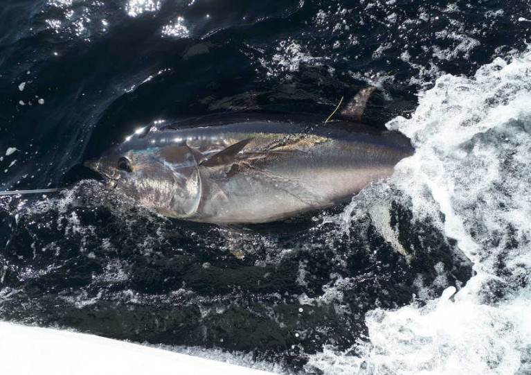
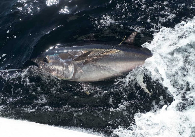
 One of the first two Atlantic bluefin tuna caught of the 2023 Tuna CHART season, captured, tagged and released off the Irish coast in late July
“To date, 1,619 bluefin tuna have been tagged by skippers along the north west, west and south coast of Ireland since the Tuna CHART programme, an inter-agency Government research initiative started in 2019.”
Recreational angling for Atlantic bluefin tuna is technically prohibited in Ireland. However, under the Tuna CHART programme, authorised charter skippers can catch, tag and release bluefin during the open season with the help of anglers as ‘citizen scientists’ on board.
This scientific tuna fishery targets the largest tuna species to collect information on their sizes, and where and when they occur in Irish waters.
The largest tuna tagged to date in the programme was 2.75m long, and weighed an estimated 372kg.
In 2022, 382 Atlantic bluefin tuna were caught, tagged, and released around the Irish coast by authorised skippers.
Skippers willingly provide their expertise to the programme and can charge anglers for bluefin tuna trips on their vessels.
Measuring, tagging and releasing bluefin tuna is carried out in the water alongside the boat, which progresses slowly at speeds of 2-3 knots, to ensure the fish remains in the best possible condition.
Bluefin are caught in area that extends from approximately 1km from the shore out to a maximum of about 20km.
Bluefin Tuna ‘Catch-Tag-Release’ Scientific Survey Programme for 2023 Opens for Charter Skippers
Ireland’s Tuna CHART bluefin tuna sea angling survey programme for 2023 has opened for charter skippers to apply.
Anglers in Ireland will once again have the opportunity to catch and release bluefin tuna in 2023 through the continuation of the Tuna CHART (CatcH And Release Tagging) programme that has been in operation around our coast since 2019.
Experienced charter skippers are now invited to apply to take part in this year’s Atlantic bluefin tuna scientific survey programme of Irish waters.
Building on the successes of the Tuna CHART programmes of 2019-2022, this scientific data collection catch-and-release fishery for Ireland will again operate in 2023.
A maximum of 25 authorisations may be granted to qualifying angling charter vessel skippers around the Irish coast for this fishery, which opens on 1 July and closes on 12 November.
The Tuna CHART programme is a collaborative scientific programme between Inland Fisheries Ireland (IFI) and the Marine Institute in partnership with the Sea Fisheries Protection Authority, Department of Agriculture, Food and the Marine (DAFM) and Department of Environment, Climate and Communications (DECC).
Between 2019 and 2022, some 1,500 Atlantic bluefin tuna were caught, tagged, measured and released off the Irish coast by authorised charter skippers. The largest tuna tagged to date in the programme was 2.75 metres, weighing an estimated 372kg.
All tuna were carefully managed in the water alongside the charter vessel, subject to strict guidelines set by the Tuna CHART programme, and all were released alive.
Data from the tagging programme have been collated by the partnership for reporting to the International Commission for the Conservation of Atlantic Tuna (ICCAT).
The core aim of the Tuna CHART programme is to collect data and tag these large fish, which is underpinned by ensuring good fish welfare, leading to successful release of the bluefin tuna.
Authorised skippers will be required to collect data on every bluefin trip undertaken and each bluefin tuna they catch, tag and release and their angling and data recording expertise is an important part of the overall survey programme. They will also be required to have high specification rods, reels and line in advance of the open season in order to ensure that the fish is brought alongside the vessel to be measured and tagged in the water in a timely manner.
Anglers will have an opportunity to participate in this fishery and contribute to this important scientific study by chartering and fishing from authorised vessels only.
Unauthorised vessels are not permitted to target or catch Bluefin tuna and any unauthorised person found to be targeting Bluefin tuna is liable to prosecution.
Experienced charter skippers are being invited to apply to join the 2023 Tuna CHART programme between Tuesday 21 March and Tuesday 4 April by filling out an application form online at www.fisheriesireland.ie/bluefin.
Bluefin Tuna ‘Catch-Tag-Release’ Scientific Survey Programme Opens for Charter Skippers
Experienced charter skippers can now apply for Ireland’s 2022 bluefin tuna scientific survey programme, as scientists confirm that over 1,100 of the largest tuna in the world have been successfully tagged and released through the programme in the last three years.
Building on the successes of the Tuna CHART (CatcH And Release Tagging) programmes of 2019-2021, this scientific data collection catch and release fishery for Ireland will operate again this year, subject to Covid-19 restrictions.
A maximum of 25 authorisations may be granted to qualifying angling charter vessel skippers around the Irish coast for the fishery, which will open on 1 July and close on 12 November.
The Tuna CHART programme is a collaborative scientific programme between Inland Fisheries Ireland and the Marine Institute in partnership with the Sea Fisheries Protection Authority, Department of Agriculture, Food and the Marine (DAFM) and Department of Environment, Climate and Communications (DECC).
Between 2019 and 2021, some 1,136 Atlantic bluefin tuna were caught, tagged, measured and released off the Irish coast by authorised charter skippers. The largest tuna tagged to date in the programme was 2.75 metres, weighing an estimated 372kg.
All tuna were carefully managed in the water alongside the charter vessel, subject to strict guidelines set by the Tuna CHART programme, and all were released alive.
Data from the tagging programme have been collated by the partnership for reporting to the International Commission for the Conservation of Atlantic Tuna (ICCAT).
The core aspect of the Tuna CHART programme is the welfare and successful release of the bluefin tuna. Authorised skippers will be required to have high specification rods, reels and line in advance of the open season in order to ensure that the fish is brought alongside the vessel to be measured and tagged in the water in a timely manner.
Anglers will have an opportunity to participate in this fishery and contribute to this important scientific study by chartering and fishing from authorised vessels only.
Unauthorised vessels are not permitted to target or catch Bluefin tuna and any unauthorised person found to be targeting Bluefin tuna is liable to prosecution.
Experienced charter skippers are being invited to apply to join the 2022 Tuna CHART programme between Monday 14 and Monday 28 February by filling out an application form online at www.fisheriesireland.ie/bluefin
Anglers in Ireland are taking part in a unique ‘catch, tag and release’ programme to help Irish and international scientists learn more about the largest tuna in the world — the Atlantic bluefin tuna.
Under the Tuna CHART (CatcH And Release Tagging) programme, recreational anglers on board 22 authorised charter vessels the successfully applied to join the scheme this year will catch bluefin tuna and skippers will be tagging and releasing them back into the sea, alive, from this month to mid November.
The data collected on board authorised vessels will then be used for scientific assessment to improve knowledge of population structures, fish size and how bluefin tuna is distributed in Irish waters and throughout the North Atlantic.
Migrating through North Atlantic waters, bluefin tuna frequent Irish coastal waters to feed. Bluefin is an iconic sports-angling species and can grow up to 1,500lbs (around 680kg).
Under strictly controlled conditions, 685 bluefin tuna were caught, tagged, measured and released through the Tuna CHART programme in 2020. All bluefin tuna were caught by anglers in Irish coastal waters and then tagged by skippers. The fish is always kept in the water to ensure correct handling and tagging.
The largest tuna tagged in Ireland in 2020 was 2.75 metres long, estimated to weigh over 800 lbs (approximately 360 kgs).
Now in its third year, Tuna CHART is a collaborative scientific programme between Inland Fisheries Ireland and the Marine Institute in partnership with the Sea-Fisheries Protection Authority, the Department of Agriculture, Food and the Marine and the Department for Environment, Climate and Communications.
Environment Minister Eamon Ryan said: “The 22 angling vessels authorised by my department will contribute substantially to essential Bluefin tuna data collection as they migrate along the Irish coastline.
“The recreational fisheries sector is crucial in the delivery of this data collection programme and we look forward to continue working with all the State agencies involved.
“I want to acknowledge the key role of the authorised charter skippers and their crews who are bringing their unique expertise to bear on providing valuable data for scientific purposes, and the ‘citizen scientist’ anglers who will catch the fish. The fact that 685 fish were tagged last year with no mortalities recorded is a great achievement by the skippers.”
‘This programme also provides our coastal communities with access to a highly desired angling market that will bring a new demographic of tourists to our spectacular Wild Atlantic Way’
Marine Minister Charlie McConalogue welcomed the continuation of the programme for 2021.
“As a Donegal man, I have a keen interest in the bluefin tuna data collection programme,” he said. “I am delighted at the ongoing success of this programme as it allows our scientific partners in the Marine Institute and Inland Fisheries Ireland to collect valuable data and improve our understanding of the migratory patterns of bluefin tuna in Irish waters in a tightly controlled environment.
“This programme also provides our coastal communities with access to a highly desired angling market that will bring a new demographic of tourists to our spectacular Wild Atlantic Way.
“I am particularly pleased with the large increase in data collected in 2020, despite the restriction in place as a result of Covid and am anticipating an even more successful season this year thanks to our experienced skippers who have received authorisations for 2021.”
This year’s authorised vessels will operate out of ports in Donegal (Killybegs and Bundoran), Sligo (Rosses Point and Mullaghmore), Galway (Cleggan and Rossaveal), Clare (Carrigaholt and Kilrush), Cork (Courtmacsherry, Kinsale, Ballycotton, Union Hall, Great Island in Cobh, Baltimore and Youghal) and Waterford (Dungarvan).
All skippers have been fully trained while vessels have been fitted with a customised GPS device. Data is collected by skippers digitally by means of a specifically designed app.
Anglers looking to fish for bluefin tuna in Irish waters may only do so from an authorised charter vessel from now until 12 November 2021. The Sea Fisheries Protection Authority and Inland Fisheries Ireland are undertaking inspections and patrols around the coast to ensure that no unauthorised vessels are targeting or catching bluefin tuna.
Both organisations have also confirmed that any person engaging in fishing for bluefin tuna on a vessel which is not appropriately authorised, would be in breach of the Sea-Fisheries and Maritime Jurisdiction (Bluefin Tuna) Regulations 2019 (SI No 265 of 2019) and would face prosecution.
Like last season, skippers will have to adhere to any local or national COVID-19 public health guidelines that may be put in place. A full list of authorised skippers and vessels for the Tuna CHART programme in 2021 can be found at www.fisheriesireland.ie/bluefin.
Bluefin Tuna Data Collection Fishery Programme Returns for 2021
Building on the success of pilot programmes in 2019 and 2020, the Tuna CHART (CatcH And Release Tagging) fishery to collect scientific data on bluefin tuna will return in 2021, subject to COVID-19 restrictions.
Tuna CHART is a collaborative scientific programme between Inland Fisheries Ireland and the Marine Institute in partnership with the Sea Fisheries Protection Authority, the Department of Agriculture, Food and the Marine (DAFM) and the Department of Environment, Climate and Communications (DECC).
In 2020, the Tuna CHART programme authorised 22 charter skippers to operate a scientific fishery — in which anglers participated fully — to catch, tag and release bluefin tuna. These professional skippers were trained to tag, measure and record bluefin data.
Despite the limitations of the pandemic, 685 bluefin tuna were caught, tagged and released around the Irish coast — a 230% increase in bluefin tagged on the previous year.
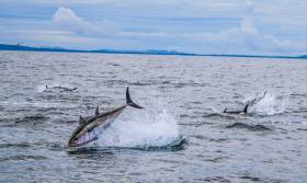
 File image of bluefin tuna in Donegal Bay Photo: David Morrissey
The most productive sites were the North-West and the South coast, mainly the waters of the Cork coastline. As many as 11 bluefin were tagged on one angling trip, a new Irish record. The largest tuna tagged was 275cm, weighing an estimated 822lbs.
All tuna were carefully handled subject to strict guidelines set by the Tuna CHART programme and all were released alive. Data from the tagging programme has been collated by the partnership for reporting to the International Commission for the Conservation of Atlantic Tuna (ICCAT).
This year a maximum of 25 authorisations may be granted to qualifying vessels and skippers around the Irish coast for fishing between 1 July and 12 November. Applications are now open and will be accepted until 1pm on Friday 9 April.
Depending on the successful operation and review of this year’s fishery, it is intended that a scientific catch-and-release fishery may also operate in 2022.
The partnership says a core aspect of the Tuna CHART programme is the welfare and successful release of the bluefin tuna. Authorised skippers will be required to have high specification rods, reels and line in advance of the open season in order to ensure that the fish is brought alongside the vessel to be measured and tagged in the water in a timely manner.
Data collection for scientific assessment is the primary purpose of the fishery and will continue to be a key requirement for skipper participation in this scientific catch-and-release fishery, the partnership adds.
Skippers will be required to collect data on every bluefin trip undertaken and each bluefin tuna they catch, tag and release, and their angling and data recording expertise is an important part of the overall survey programme.
Anglers will have an opportunity to participate in this fishery and contribute to this important scientific study by chartering and fishing from authorised vessels only. Unauthorised vessels are not permitted to target or catch bluefin tuna, and any unauthorised person found to be targeting bluefin tuna will be prosecuted. Applications for authorisations are open to charter skippers only.

Twenty-two charter angling vessels have been granted authorisation to participate in a bluefin tuna data collection programme after a successful pilot last year.
The Tuna CHART (CatcH And Release Tagging) programme will see skippers catch, tag, measure and release Atlantic bluefin tuna for data collection purposes off the Irish coast.
The authorised vessels, which are located in Cork, Clare, Galway, Sligo and Donegal, will support an international scientific programme to increase knowledge of the behaviour and abundance of bluefin tuna in Irish waters and across its distribution generally.
Atlantic bluefin tuna, the largest tuna in the world, frequent Irish coastal waters to feed during the species’ annual migration through North Atlantic waters.
The bluefin tuna is prized by sea anglers for its power and fighting ability and is a very valuable commercial species, though there is currently no sport or commercial fishery for bluefin tuna in Ireland.
The new programme, which has been developed by Inland Fisheries Ireland and the Marine Institute in partnership with the Sea Fisheries Protection Authority and the former Departments of Agriculture, Food and the Marine, and Communications, Climate Action and Environment, will operate again in 2020 having commenced on a pilot basis in 2019.
Eamon Ryan TD, minister with responsibility for inland fisheries, said: “The 22 angling vessels authorised by my department, increased from 15 last year, will contribute substantially to essential bluefin tuna data collection as they migrate along the Irish coastline.
“The recreational fisheries sector is crucial in the delivery of this research programme and we look forward to continue working with all the State agencies involved.
“I want to acknowledge the key role of the authorised charter skippers and their crews who are bringing their unique expertise to bear on providing valuable data for scientific purposes, and the ‘citizen scientist’ anglers who will catch the fish. The fact that 209 fish were tagged last year with no mortalities is a great achievement by the skippers.”
The Sea Fisheries Protection Authority and Inland Fisheries Ireland will undertake inspections and patrols around the coast to ensure this remains a strictly controlled programme.
A full list of authorised skippers can be found at www.fisheriesireland.ie/bluefin
Building on the success of last year’s Tuna CHART (CatcH And Release Tagging) pilot programme, a bluefin tuna research catch-and-release fishery for Ireland will operate in 2020.
A maximum of 25 authorisations may be granted to qualifying angling charter vessel skippers around the Irish coast for this fishery which will open on Wednesday 1 July and close on Thursday 12 November, without exception.
And depending on the successful operation and review of this year’s fishery, it is intended that a scientific catch and release fishery may also operate in 2021 and 2022.
Atlantic bluefin tuna, the largest tuna in the world, frequent Irish coastal waters to feed during its annual migration through North Atlantic waters. The bluefin tuna is prized by sea anglers for its power and fighting ability and is a very valuable commercial species.
The Tuna CHART programme is a collaborative scientific programme between Inland Fisheries Ireland (IFI) and the Marine Institute in partnership with the Sea Fisheries Protection Authority, the Department of Agriculture, Food and the Marine (DAFM) and the Department of Communications, Climate Action and Environment (DCCAE).
In 2019, the Tuna CHART pilot programme authorised 15 charter skippers to operate a scientific fishery, in which anglers participated fully, to catch, tag and release bluefin tuna.
These professional skippers were trained to tag, measure and record bluefin data and over the course of the 2019 three month season, 219 bluefin tuna were caught, tagged and released. As many as eight bluefin were tagged on one fishing trip.
All tuna were carefully handled subject to strict guidelines set by the Tuna CHART programme and all were released alive. Data from the tagging programme are being collated by the partnership for reporting to the International Commission for the Conservation of Atlantic Tuna (ICCAT).
As with the pilot programme, this year’s authorised skippers will be required to have high specification rods, reels and line in advance of the open season in order to bring the fish alongside in a timely manner. Skippers will be required to collect data on every bluefin trip undertaken and each bluefin tuna they catch, tag and release.
A call for applications for the 2020 fishing season will be announced next Tuesday 18 February and the last date for the receipt of a completed application will be 1pm on Friday 6 March.
Fifteen angling vessels will soon be granted authorisation to participate in Tuna CHART (Catch and Release Tagging), a pilot Bluefin Tuna Data Collection Programme.
As previously reported for Afloat.ie by Lorna Siggins, the programme will see the 15 authorised vessels catch, tag and release Atlantic bluefin tuna for data collection purposes off the Irish coast.
These vessels, which are located in Cork, Clare, Galway, Sligo and Donegal, will support scientific work to increase knowledge of the behaviour and abundance of bluefin tuna in Irish waters — which currently do not host a sport or commercial fishery for the species.
The new programme, which has been developed by Inland Fisheries Ireland (IFI) and the Marine Institute in partnership with the Sea Fisheries Protection Authority (SFPA), the Department of Agriculture, Food and the Marine and the Department for Communications, Climate Action and Environment (DCCAE), will operate on a pilot basis this year.
Authorisations will be granted from mid-August until mid-October, and all skippers and trained crew have participated in training with guidance provided around fish handling, welfare, tagging and data recording.
Participants in the programme will catch, tag and release bluefin tuna while adhering to strict fish safety and handling procedures at all times.
Marine Minister Michael Creed has welcomed the initiative. “My department has been working on this project for two years at both EU and domestic levels and I am happy to announce the commencement of the project this month,” he said.
“This initiative will allow the Marine Institute and Inland Fisheries Ireland to collect valuable data on the migratory patterns of bluefin tuna in Irish waters in a tightly controlled environment.
“This project has been a wonderful example of co-operation between my department, DCCAE, SFPA, IFI and the Marine Institute and I am looking forward to the continued development of this relationship.”
Sean Canney, Minister with responsibility for inland fisheries, added: “The angling vessels which will be receiving authorisation from my department will contribute in a very tangible way to important data collection around Bluefin tuna as they migrate past the Irish coastline.
“The recreational fisheries sector is crucial in the delivery of this pilot programme and we look forward to working with all the State agencies involved and critically with the skippers and their crews who have received authorisations in providing valuable data for scientific purposes.”
The SFPA and IFI will undertake inspections and patrols around the coast to ensure this remains a strictly controlled fishery.
Anglers wishing to engage in this fishery must only do so on a sea angling vessel specifically authorised to participate in the pilot programme. Any person engaging in this fishery on any vessel which is not appropriately authorised will be in breach of the Sea-Fisheries and Maritime Jurisdiction (Bluefin Tuna) Regulations 2019 (SI No 265 of 2019).


 according to the Environmental Protection Agency")


 NIFA director John Menarry, NIFA chairman Michael Desmond, and NIFA director Eamon Dixon")


 for the new skiff and builder Patsy Whelan Jnr.")


 with his exuberant crew as they celebrate being overall winners of Howth Wave 2024")
