Menu

Ireland's sailing, boating & maritime magazine

Displaying items by tag: EastLink Toll Bridge

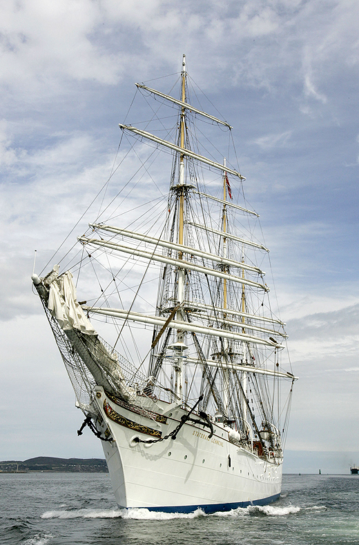
#EastLink@30 – Naval Service OPV L.E. Aisling (P23) took the honour of passing through Dublin's East-Link Toll Bridge as the Liffey road crossing celebrated opening to traffic 30 years ago today, writes Jehan Ashmore.

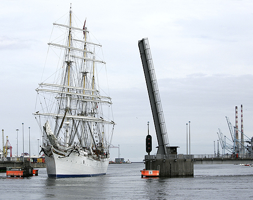
The final of the 'Emer' OPV class built sisters made the transit of the bridge built to a bascule design in which the 'lifting' span of 45 metres wide was raised. The opening span weighing 500 tons is tilted to 80 degrees and taking less than a minute to complete. This allowed the L.E Aisling to continue upriver to berth along Sir John Rogersons Quay.

When the bridge was opened on 21st October 1984, this created a new eastern by-pass of the capital however this was to be an end of era with the withdrawal of the Liffey ferry, albeit a foot-passenger only service.

The ferry was used as short cut mostly for 'dockers' as otherwise the next fixed link bridging the Liffey three decades ago was the Matt Talbot Memorial Bridge. This structure was close to where the last Guinness stout-ships berthed, The Lady Patricia and Miranda Guinness along Sir John Rogersons Quay.

The stout-tankers were the last ships to regularly transit the East-Link Bridge until 1993. They exported the 'black stuff' to Runcorn on the Manchester Ship Canal.

The East-Link Bridge has a strong commuter profile with approximately 17,500 vehicles daily using the bridge connecting the north and south quays. The bridge spanning 150 metres was the vision of Tom Roche (senior) founder of the National Toll Roads, the original operators of the tolled bridge.

Not only is the bridge used by car motorists but notably is a national strategic infrastructure asset for freight trucks to access the port. As the years passed with the opening of the Dublin Port Tunnel, this formed another key part of the overall port related road network and to further alleviate congestion away from the city-centre quays.

Another milestone in the infrastructure of bridging the Liffey was the Samuel Beckett Bridge which ironically itself made a transit through the East-Link Bridge. The structure was loaded on board a barge in The Netherlands and was towed to Dublin Port in 2009 for installation. The Samuel Beckett Bridge is of a swing-bridge design in which the whole bridge pivots on a single pier.

It was in May this year when another of the Naval Service's OPV's the newbuild L.E. Samuel Beckett (P61) moored close to the bridge also bearing the name of the playright as the vessel was christened along the south quays.

For a speeded up footage taken on board from the mast of the newbuild as she headed into Dublin Port and through the East-Link Bridge prior to her naming ceremony, click HERE.


Published in Coastal Notes

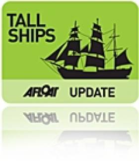
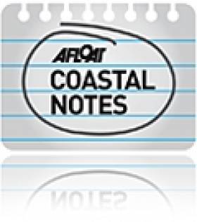
The arrival of the largest and oldest Norwegian tallship the barque S/S Statsraad Lehmkuhl into Dublin Port yesterday made for an impressive sight, even without her sails set, writes Jehan Ashmore.

At nearly a century-old the square-rigged ship eased her way through the East-Link toll bridge where she proceeded to berth at Sir John Rogersons Quay, where she will be open to the public today between 12:00 – 16:30 and tomorrow,Saturday the 20th August from 10:00 –12:00. Her berth is downriver of the Samuel Beckett swing-bridge and the nearest DART stations are at Grand Canal Dock and Pearse St.
statsraad_1
Statsraad Lehmkuhl is 321-feet long and the barque is also one of the largest three-masted sailing ships in the world. The height from the water-line to the top of the mainmast is 240-feet and in total she carries 22 sails which cover an area of over 2,000 square metres. Under canvass she can achieve 18 knots or when under motor-power her 1,125hp diesel engine manages 11 knots. 
statsraad_2
As reported on Afloat.ie the steel-hulled barque departed her homeport of Bergen last week on a voyage across the North Sea to include a call to Stornoway on the Isle of Lewis. She was built in 1914 originally for the German Merchant Marine and at nearly a century-old she has had a colourful career having changed hands between Germany and Britain during both World Wars.
Since 1978 she has been with her current operators the Statsraad Lehmkuhl Foundation, based in the Nordic's country's second largest city. For further information about the 1,516-tonnes vessel specifications click HERE and interior illustration of deck layout click HERE.
statsraad_3

Her arrival marks nearly a year in advance to Dublin City welcoming the return of the Tall Ships Races, presented by Szczecin and organised by Sail Training International. The capital last hosted the event in 1998 and next year up to 100 tall ships are to sail into the capital which will be the final host port for four days between 23rd-26th August 2012.

statsraad_4

Tall Ship S/S Statsraad Lehmkuh in Dublin Bay yesterday. Images: Iain White

The celebration of sail is expected to draw entrants from as far away as Chile, Mexico, Argentina, USA and European and Baltic countries including Italy and Norway will chart their course to Dublin. It is hoped that the event will attract over a million visitors to the city, topping the 500,000 spectators who thronged the Waterford quays during this year's tall ship race gathering.

tallship_jehan

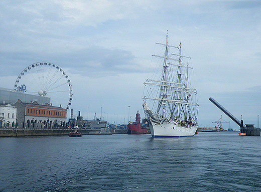
Photo: Jehan Ashmore

Published in Tall Ships
The public will have greater access to see shipping activity in the Port of Dublin, when a new boat-based tour of the country's busiest port starts tomorrow, writes Jehan Ashmore.
Titled the River Liffey & Port Tour, the 45-minute excursion is a partnership between Sea Safari Tours and the Dublin Port Company. Tours will operate from the pontoon where the M.V. Cill Airne floating river-restaurant and bar venue is berthed at the North Wall Quay. Cill Airne was built in the Liffey Dockyard nearly fifty years ago, where she forms part of the tours audio commentary covering the history and the present day.

In addition to cruising this stretch of the River Liffey alongside the 'Docklands' quarter, the tour RIB boat will pass downriver through the East-Link toll bridge where visitors will get closer views of the variety of vessels and calling cruise liners from other ports throughout the world.

There will be five daily tours beginning at 10.00am, 12.00pm, 2.00pm, 4.00pm and 6.00pm.Tickets cost €15.00 for adults, €12.50 for students and the charge for senior citizens and children is €10.00.

In addition Sea Safari operate a 'River Liffey' only tour, a Dublin Bay 'North' and 'South' tours which visit Howth Head, Baily Lighthouse, Ireland's Eye and to Dalkey Island and Killiney Bay, where both bay tours provide a chance to spot local marine wildlife of seals, porpoises and sea birds.

Published in Dublin Port
With sweeping lines the 54m private motor-yacht Fortunate Sun became the largest vessel to transit Dublin's Samuel Beckett swing-bridge, writes Jehan Ashmore.
The motoryacht (click PHOTO) which has luxurious accommodation for 10 guests and 12 crew had sailed from the Scottish western isles and made a lunchtime arrival on Wednesday, where the vessel initially docked at Ocean Pier, Dublin Port.

She remained alongside this berth which is normally used by large commercial ships until the vessel sought a berth much closer to the city-centre. This led to a shift of berths in the evening when the 2003 built vessel headed upriver to the Dublin City Moorings facility at Custom House Quay, but this firstly required transiting through two bridges.

With a beam of 10.6m Fortunate Sun entered through the East-Link toll-lift bridge followed by the Samuel Beckett bridge, the Liffey's newest crossing point which opened in late 2009. The €60m bridge was commissioned by Dublin City Council and designed by the Spanish architect engineer Santiago Calatrava. To read more on the bridge click HERE.

Fortunate Sun is registered in the Caymen Islands and is capable of over 17 knots on a range of 5000 nautical miles. She has a steel hull and an aluminium superstructure and interiors also by Tim Heywood Design. In the early hours of tomorrow morning the vessel built by Oceanfast is to depart through the 5,700 tonnes bridge which was delivered by barge after a five-day voyage from Rotterdam.

There has been previous transits of the bridge notably the annual Dublin Rally organised by the the Inland Waterways Association of Ireland (IWAI). This year's Dublin Rally took place on 1 May when boats travelling on the Royal Canal descended via Croke Park and entered the Liffey at Spencer Dock. This required the Iarnrod Éireann bridge-lift and the water level in Spencer Dock to be lowered so to allow safe clearance under the Sheriff St. bridge.

From there the IWAI flotilla made the short passage downriver to re-enter another inland waterway system at the Grand Canal Dock, marking where the Liffey connects with the city's southern canal. The 2011 Dublin Rally was the first time since 1955 that boats could enter Dublin from the Shannon via the Royal Canal and the first time since 2004 that boats also joined from the Royal Canal.

Published in Ports & Shipping
The Dublin Bay Old Gaffers Association (DBOG) continue with their lecture programme in the Poolbeg Yacht Boat Club & Marina (PYBC). The next lecture "The Circumnavigation – Continued " will be presented by Pat & Olivia Murphy and is to be held on Tuesday 5 April.
The lecture starts at 8 pm but the organisers are encouraging those wishing to attend to assemble at 7.15 pm for a socialable drink in advance.
Poolbeg clubhouse overlooks the marina and faces the entrance to Alexandra Basin, where shipping activities of the commercial port can be viewed in closer detail.
To reach the clubhouse which is located on the South Bank, Pigeon House Road, Ringsend, take the Sean Moore Road that connects the Merrion Strand Road (from the south) and the East-Link Toll Bridge (if travelling from the northside).

For further information on the lectures to date click this link and in general about the DBOGA logon here. To contact the PYBC Tel: (01) 668 9983 or logon to www.poolbegmarina.ie/

Published in Boating Fixtures
The next lecture organised by the Dublin Bay Old Gaffers Association (DBOG) will be "Diving The Wreck of the Bolivar on the Kish Bank" by Cormac Lowth. The lecture will take place in the Poolbeg Yacht Boat Club & Marina (PYBC) at 8pm on Tuesday 8 March.
The lecture will examine the story of the ship, the shipwreck, the re-discovery and diving and fishery. In addition many other shipwrecks dived by the speaker will be included and accompanied with illustrations.

The talks proper will begin at 8 pm but the organisers are encouraging those wishing to attend to assemble at 7.15 pm for a socialable drink in advance of the talk starting. All are welcome and the admission is free, noting a donation for the RNLI will be held at the door. For further information about the DBOGA logon to www.dublinbayoldgaffersassociation.com/

The Poolbeg yacht clubhouse is located on the South Bank, Pigeon House Road, Ringsend which can be accessed from the Sean Moore Road that connects the Merrion Strand Road (from the south) and the East-Link Toll Bridge (from the north). For information in general about the PYBC Tel: (01) 668 9983 or logon to www.poolbegmarina.ie/

Published in Boating Fixtures

Marine Protected Areas (MPAs) - FAQS

Marine protected areas (MPAs) are geographically defined maritime areas where human activities are managed to protect important natural or cultural resources. In addition to conserving marine species and habitats, MPAs can support maritime economic activity and reduce the effects of climate change and ocean acidification.

MPAs can be found across a range of marine habitats, from the open ocean to coastal areas, intertidal zones, bays and estuaries. Marine protected areas are defined areas where human activities are managed to protect important natural or cultural resources.

The world's first MPA is said to have been the Fort Jefferson National Monument in Florida, North America, which covered 18,850 hectares of sea and 35 hectares of coastal land. This location was designated in 1935, but the main drive for MPAs came much later. The current global movement can be traced to the first World Congress on National Parks in 1962, and initiation in 1976 of a process to deliver exclusive rights to sovereign states over waters up to 200 nautical miles out then began to provide new focus

The Rio ‘Earth Summit’ on climate change in 1992 saw a global MPA area target of 10% by the 2010 deadline. When this was not met, an “Aichi target 11” was set requiring 10% coverage by 2020. There has been repeated efforts since then to tighten up MPA requirements.

Marae Moana is a multiple-use marine protected area created on July 13th 2017 by the government of the Cook islands in the south Pacific, north- east of New Zealand. The area extends across over 1.9 million square kilometres. However, In September 2019, Jacqueline Evans, a prominent marine biologist and Goldman environmental award winner who was openly critical of the government's plans for seabed mining, was replaced as director of the park by the Cook Islands prime minister’s office. The move attracted local media criticism, as Evans was responsible for developing the Marae Moana policy and the Marae Moana Act, She had worked on raising funding for the park, expanding policy and regulations and developing a plan that designates permitted areas for industrial activities.

Criteria for identifying and selecting MPAs depends on the overall objective or direction of the programme identified by the coastal state. For example, if the objective is to safeguard ecological habitats, the criteria will emphasise habitat diversity and the unique nature of the particular area.

Permanence of MPAs can vary internationally. Some are established under legislative action or under a different regulatory mechanism to exist permanently into the future. Others are intended to last only a few months or years.

Yes, Ireland has MPA cover in about 2.13 per cent of our waters. Although much of Ireland’s marine environment is regarded as in “generally good condition”, according to an expert group report for Government published in January 2021, it says that biodiversity loss and ecosystem degradation are of “wide concern due to increasing pressures such as overexploitation, habitat loss, pollution, and climate change”.

The Government has set a target of 30 per cent MPA coverage by 2030, and moves are already being made in that direction. However, environmentalists are dubious, pointing out that a previous target of ten per cent by 2020 was not met.

Conservation and sustainable management of the marine environment has been mandated by a number of international agreements and legal obligations, as an expert group report to government has pointed out. There are specific requirements for area-based protection in the EU Marine Strategy Framework Directive (MSFD), the OSPAR Convention, the UN Convention on Biological Diversity and the UN Sustainable Development Goals. 

Yes, the Marine Strategy Framework directive (2008/56/EC) required member states to put measures in place to achieve or maintain good environmental status in their waters by 2020. Under the directive a coherent and representative network of MPAs had to be created by 2016.

Ireland was about halfway up the EU table in designating protected areas under existing habitats and bird directives in a comparison published by the European Commission in 2009. However, the Fair Seas campaign, an environmental coalition formed in 2022, points out that Ireland is “lagging behind “ even our closest neighbours, such as Scotland which has 37 per cent. The Fair Seas campaign wants at least 10 per cent of Irish waters to be designated as “fully protected” by 2025, and “at least” 30 per cent by 2030.

Nearly a quarter of Britain’s territorial waters are covered by MPAs, set up to protect vital ecosystems and species. However, a conservation NGO, Oceana, said that analysis of fishing vessel tracking data published in The Guardian in October 2020 found that more than 97% of British MPAs created to safeguard ocean habitats, are being dredged and bottom trawled. 

There’s the rub. Currently, there is no definition of an MPA in Irish law, and environment protections under the Wildlife Acts only apply to the foreshore.

Current protection in marine areas beyond 12 nautical miles is limited to measures taken under the EU Birds and Habitats Directives or the OSPAR Convention. This means that habitats and species that are not listed in the EU Directives, but which may be locally, nationally or internationally important, cannot currently be afforded the necessary protection

Yes. In late March 2022, Minister for Housing Darragh O’Brien said that the Government had begun developing “stand-alone legislation” to enable identification, designation and management of MPAs to meet Ireland’s national and international commitments.

Yes. Environmental groups are not happy, as they have pointed out that legislation on marine planning took precedence over legislation on MPAs, due to the push to develop offshore renewable energy.

No, but some activities may be banned or restricted. Extraction is the main activity affected as in oil and gas activities; mining; dumping; and bottom trawling

The Government’s expert group report noted that MPA designations are likely to have the greatest influence on the “capture fisheries, marine tourism and aquaculture sectors”. It said research suggests that the net impacts on fisheries could ultimately be either positive or negative and will depend on the type of fishery involved and a wide array of other factors.

The same report noted that marine tourism and recreation sector can substantially benefit from MPA designation. However, it said that the “magnitude of the benefits” will depend to a large extent on the location of the MPA sites within the network and the management measures put in place.

© Afloat 2022