


Displaying items by tag: wind
Met Éireann Issues Small Craft Warning as Rain and Winds Sweep In

#WEATHER - Met Éireann has issued a weather warning for much of the Irish coast today (Monday 24 September) as heavy rain and strong northwesterly winds sweep in across the country.
Winds are expected to reach gale force tonight on northwestern, northern and eastern coasts from Erris Head in Mayo to Malin in Donegal to Wicklow Head.
As The Irish Times reports, fishermen in small craft are advised to take caution as wind speeds are set to top force six or higher as the day progresses.
Persistent rainfall in most of Leinster and Ulster may also lead to flash flooding in some areas.
Summer Gale Threatens Sailing Fixtures

#weather – A deep area of low pressure off Southern Ireland with fronts pushing north threatens to disrupt a number of sailing events on the Irish Sea from this afternoon including tonight's regular Dublin Bay Sailing Club (DBSC) 200 boat plus racing and even tomorrow night's fiftieth Ailsa Craig race from Belfast Lough.
South easterly winds will be increasing and gales are expected today. Thickening cloud and outbreaks of rain through this afternoon. The rain becoming more persistent as the day progresses.
Depending on how fast the fronts move weekend sailing may also be affected, the hope being that the gale will have passed through before the Ruffian Nationals begin at the Royal St. George Yacht Club in Dun Laoghaire and the Laser Leinster championships start in Howth.
There will be further rain through this evening, this becoming heavy at times.
Winds will be to gale force later, and visibility will become increasingly moderate in rain, then poor later. Sea state will be rough then very rough.
Dun Laoghaire marina has issued a forecast that warns of SE 25-28kt - SE 30-38kt from 6pm this evening.
#MCIB - The decision to set out in poor weather, coupled with limited safety instruction, led to the tragic death of a Romanian angler on Lough Mask last summer, according to a report by the Marine Casualty Investigation Board (MCIB).
Mircea Ungur drowned after the angling boat he was in capsized in choppy waters brought on by squalling Force 8 winds on the afternoon of 8 May 2011.
Ungur had a tracheostomy tube in his throat resulting from a previous battle against throat cancer, and drowned after taking in water through this tube, the MCIB concluded. It was also found that most of his companions and the guide knew nothing about the tube.
At the time of the incident, Ungur had been on an angling holiday in Co Mayo with five colleagues accompanied by a fishing guide. On the morning of 8 May the group set out from Cappaduff in Tourmakeady on two boats, following a brief discussion about fishing and safe departure from the pier.
Winds were already reaching Force 4-6 when the group departed and sought a sheltered area of the lough to fish. After lunch winds had picked up to Force 8 and the guide signalled for a return to Tourmakeady.
At around 1.5km from the pier at Cappaduff, a wave swamped the leading boat that contained Ungur, a companion and the guide. All three on board, who were wearing buoyancy aids, went into the water.
Ungur was the first taken on board the other boat after some 10 minutes in the water. He was not moving or communicating with the others, and CPR was not administered until the boat reached the shore 20 minutes later. Ungur was pronouced dead just before 3pm.
The report concluded that the group had departed despite reservations among them about the poor weather, which had been correctly forecast that day. There was also little discussion with the anglers about their level of boating experience, the weather, or any disabilities that would affect their safety on the water.
The MCIB recommended that a full safety briefing should be given to all those hiring angling boats. It also urged the enforcement of safety regulations and certification for recreational water craft.
The full report is available to download as a PDF from the MCIB website HERE.
Ship-to-Ship Transfer of OIl Cargo Delayed Yet Again

#SHIPPING - The transfer of hazardous cargo from the stricken tanker at the entrance to Belfast Lough has been delayed yet again due to winds nearing hurricane strength.
The Belfast Telegraph reports that the Genmar Conpanion - which was redirected to Belfast after reporting a cracked hull en route from Rotterdam to New York - will remain sheltering off the Copeland Islands until the weather improves.
As previously reported on Afloat.ie, the ship-to-ship transfer of 54,000 tonnes of vacuum gas oil was originally scheduled to take place on 31 December last, but the task was pushed back as the receiving ship, BW Seine, was delayed by weather in the North Sea.
It had then been hoped to begin the transfer early yesterday with the receiving ship's arrival, but the strong storm-force winds that have increasingly battered Ireland in the last 36 hours put paid to those plans.
Ship-to-ship transfers can take place in wind speeds of up to 35 knots, but yesterday the wind speed in Belfast Lough was reported as more than double that.
Hugh Shaw, the NI Secretary of State's representative for maritime salvage and intervention, told the Belfast Telegraph: "As soon as we have a window to do the ship-to-ship transfer safely we will take it.
"Winds have been dropping a bit, but it looks unlikely the operation will take place on Wednesday."
Ireland Battered by Storm-Force Winds

#WEATHER - Ireland has been warned to brace for further strong winds set to sweep across the country today (4 January),
The Irish Times reports. Winds reaching near hurricane speeds have affected coastal communities in the north and northwest, peaking at a remarkable 168km/h in Donegal.
Thousands of euro worth of damage was caused when the roofs of traditional thatched cottages at Cruit Island in west Donegal were blown away.
But the west and east have also been hard hit, with storm-force gales exceeding 100km/h uprooting trees and disrupting electricity supply.
As previously reported on Afloat.ie, ferry services on the east coast have been severely affected. Irish Ferries cancelled two fast ferries from Dublin to Holyhead yesterday, and today's early Jonathan Swift sailings between Dublin and Holyhead were also cancelled.
Met Éireann expects wind speeds to be lower today, but could still reach 90-120km/h in some areas.
The Irish Times has much more on the story HERE.
Storm Force Wind Warning In Effect for Irish Coast

#WEATHER - The Irish Coast Guard has warned people to stay away from cliff paths and other coastal areas as near hurricane force winds continue to batter the country, the Irish Examiner reports.
As of this morning, Met Éireann was expecting gusts of up to 140 kilometres an hour in Connacht and Ulster.
All Irish coastal areas are expected to experience strong gales. Winds will occasionally reaching violent storm force 11 on coasts from Rossan Point to Malin Head to Fair Head this afternoon, according to meteorologists.
Whale Carcass Battered by Strong Sea Gales in Sligo

#MARINE WILDLIFE - The Irish Independent reports on the carcass of a whale that was strewn on a beach in Co Sligo after it was swept into rocks by Monday's gale-force winds.
The 13-metre fin whale had been seen recently on a number of occasions in Lough Hyne, a saltwater lake near Baltimore in Co Cork.
On Monday it was spotted at Raughley in the north of Sligo, where it was found beached by Jimmy and Viera Stupakova after the treacherous conditions of the early part of this week.
The find marks the fifth recorded stranding of the species in Irish waters, and the first validated record of a fin whale in Co Sligo, according to OutdoorCommunity.ie.
It is not yet clear how the juvenile met its end, though initial investigations point to the whale not being long dead.
The Irish Independent has more on the story, including video, HERE.
Weather Warning for Irish Sea as Winter Winds Sweep In

#WEATHER - Met Éireann has issued a weather warning for the Irish Sea for the next 24 hours due to expected gale force westery winds.
A small craft warning has also been issued, with west to southwest winds continuing to reach force 6 tonight on the Irish coast from Carlingford Lough to Roches Point to Slyne Head.
The high winds marks the first wave of real winter weather after a milder-than-average November, the Evening Herald reports.
A forecaster told the paper that strong winds have "reached storm force on the Irish coasts from Belfast Lough to Wicklow Head to Mizen Head and on the Irish Sea.
"We expect that by tonight they will slightly drop but may still reach a strong gale force."
NI Recovers After Battering by Hurricane Katia

Northern Ireland is recovering after Hurricane Katia left power cuts and travel distruption in its wake.
As previously reported on Afloat.ie, the remains of Hurrican Katia had been expected to strike hardest in the northern half of Ireland.
The Belfast Telegraph reports that Derry, Antrim and Tyrone were worst hit by winds that reached speeds of up to 120kph on Monday.
There was widespread disruption to rail and ferry services, while drivers reported hazardous conditions. The Foyle Bridge was closed to all high-sided vehiches for a time.
Some 700 homes across Northern Ireland suffered a blackout when powerlines were cut and by falling trees and windborne debris, though power was mostly restored by Tuesday evening.
Though downgraded to tropical storm status after crossing the Atlantic, Katia's high winds wreaked similar havoc south of the border, with power cuts to over 13,000 homes in six different counties - half of them in Donegal alone.
Wind gusts of an incredible 137kmh were recorded on Arranmore Island.
The Belfast Telegraph has more on the story HERE.
Ireland Battens Down the Hatches for Hurricane Katia
Ireland has battened down the hatches because of fears Hurricane Katia would wreak widespread havoc with storm-force winds and giant waves. The Coast Guard has issued a weather alert warning people to stay away from cliff edges. Boaters are also warned of the dangers of walking near exposed quays.
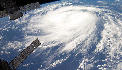
Hurricane Katia as seen from the space station


, at the sod-turning event for the new Deep Water Quay Development at the Rossaveal Fishery Harbour Centre. (Forbairt Ché Dhomhain, Lárionad Chuan Iascaigh Ros An Mhíl) in February")

