


Displaying items by tag: archaeology
Dublin Port Discovers City’s Original 18th-Century Sea Wall
Part of Dublin’s original sea wall dating back to the late 1720s has been discovered during excavations beneath a former electricity substation at Dublin Port.
Announcing the find today (Wednesday 5 October), Dublin Port Company also revealed the discovery of dockworker artefacts including clay pipes, leather shoe parts and pottery fragments from the 19th century.
The “historic” unearthing was made during works being carried out on the former redbrick electricity substation located near the junction of East Wall Road and Alexandra Road in the grounds of Port Centre.
“The original sea wall once enclosed the eastern and northern sides of newly reclaimed land that would become known as the North Lotts – acting as a polder,” the port company explains.
“As the port extended eastwards away from the city, the sea wall’s original purpose became obsolete, and the facing stones of the wall were removed.
“It is likely that the stones were re-used to construct the three-metre-high boundary wall that defines the port’s perimeter today, visible from East Wall Road. It is from this original sea wall that the area known as East Wall derives its name today.”
Jim Kelleher, head of special projects with the port’s heritage and communications team, said: “We have long suspected that part of the original sea wall may have lain beneath the old redbrick substation, which itself is a protected structure.
“But it has been incredibly exciting to have those suspicions confirmed, and to see this part of the original ‘East Wall’ for the first time.”
The port company promises that the sea wall — visible through a glass floor — and related items will on permanent display within the restored substation at Port Centre. Dublin Port has more on the story HERE.
Waterways Ireland advises masters of vessels on the Shannon Navigation that an underwater archaeological survey adjacent to Wansboro Field, Athlone will take place this Friday 22 October.
The survey is expected to run from 9am to 2pm, and all vessels are asked to take additional care when underway in this area of the inland waterway within the aforementioned hours.
Stormy Weather Exposes Shipwreck Near Killary Harbour
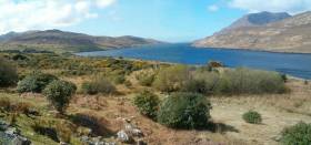
#Archaeology - With yet another stormy weekend comes news that continued coastal erosion on the West Coast has exposed the remains of a shipwreck at Killary Harbour.
According to The Irish Times, the wreck on Tallaghbaun Strand is already known to locals though its origins are as yet unclear.
But archaeologist Michael Gibbons believes it could date from the late medieval period, as wrecks from the Spanish Armada have been identified in the region.
Gibbons has also been researching what appear to be the remains of a late Bronze Age or early Christian monastic site on Kid Island in Broadhaven Bay. The Irish Times has more on the story HERE.
900-Year-Old Brooch Found On Omey Island
#Archaeology - It was quite a turn-up for the books on Omey Island recently as a US student found a 12th-century brooch in the sand on the Connemara tidal island.
As The Irish Times reports, the rare kite brooch was discovered by chance by McKenna McFadden while on a field trip with fellow New York University students led by Michael Gibbons, a local archaeologist.
It's since been identified as being 900 years old, and will be offered to the collection of the National Museum.
Omey Island is also the subject of a new book charting its remarkable history, as previously reported on Afloat.ie.
'Rescue' Needed For Sensitive Sites After Storm Rachel Coastal Damage

#StormRachel - Ireland needs a dedicated 'rescue unit' to protect sensitive heritage sites around the coast from severe weather, as news of damage to some vulnerable spots emerges.
Michael Gibbons, an archaeologist from Connemara, told The Irish Times that while the high winds whipped up by the likes of last week's Storm Rachel have helped uncover new archaeological finds, there is as yet no procedure for protecting such finds from further weathering and erosion.
Gibbons commented specifically on the midden deposits uncovered in Roundstone on Galway Bay, which were hit by strong gales and exposed the vulnerable dunes in the area to further destruction.
The Irish Times has more on the story HERE.
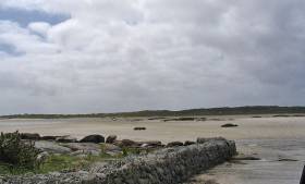
Farmer Finds 'Important Piece Of History' At Spanish Armada Wreck Beach

#SpanishArmada - A rudder from a ship that formed part of the Spanish Armada discovered at a beach in Co Sligo recently has been transferred to the care of the National Museum for preservation and study.
As Sligo Today reports, the 20-foot rudder was found on the beach at Streedagh – renowned for hosting the wrecks of three ships from the 1588 galleon fleet – by a local farmer, who contacted the Department of Heritage's Underwater Archaeology Unit.
Dr Nessa O'Connor of the National Museum, who was engaged to dive at the Streedagh site with Dr Douglas McElvogue of the Mary Rose Trust, was said to be so impressed with the discovery that she arranged for it to be immediately removed for preservation.
The rudder is almost completely intact, with a piece missing which the archaeologists believe may have been picked up at random by a passer by believing it to be driftwood.
It's hoped that this part can be recovered to put together "an important piece of history". Sligo Today has more on the story HERE.
Lough Hyne Flint A Big Find For Archaeologists

#CoastalNotes - The recent discovery of a piece of worked flint at Lough Hyne on the West Cork coast could unlock the secrets of 4,000 years of settlement in the area.
Cork's Southern Star reports that the archaeological find at Ballinard on the marine lake and nature reserve is what remains of a core piece of flint "which would have been worked on, or knapped, by a skilled stone worker" to create tools such as blades and arrowheads.
It's unknown how the flint came to be in the area, as it is not a rock common to West Cork, though it is supposed that it arrived either as a result of trade with people from the Antrim area - Ireland's main source of flint - or brought ashore as 'moonstones' by fishermen off what is now Galley Head.
The Southern Star has much more on the story HERE.
New Archaeological Discoveries in Galway Bay

#GALWAY BAY NEWS - Archaeologists in Galway Bay have unearthed an extensive tidal weir complex at Barna and a late medieval quay on Mutton Island, The Irish Times reports.
The weir, which is estimated to date from the early Christian period, consists of a granite barrier with channels cut through it, designed to control the flow of water in the adjacent lagoon.
Connemara archaeologist Michael Gibbons suggests that the weir implies a considerable fish stock migrating through the area into the Barna river.
The remains of a large Iron Age fort which overlooks the site may also have given its name to the townland of Knocknacarra, which is now a populous suburb of Galway.
Meanwhile, further east at Mutton Island a medieval quay which predates the current lighthouse quay has been found.
The Irish Times has more on the story HERE.


, at the sod-turning event for the new Deep Water Quay Development at the Rossaveal Fishery Harbour Centre. (Forbairt Ché Dhomhain, Lárionad Chuan Iascaigh Ros An Mhíl) in February")

: helm Nathan Burke, station mechanic and coxswain Kieran ‘Colley’ O’Connell and helm Gary Hayes")
