Menu

Ireland's sailing, boating & maritime magazine

Dublin Bay Boating News and Information

Displaying items by tag: Landfill

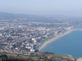
#Pollution - An old landfill site in Bray continues to leak hazardous waste into the Irish Sea, according to TheJournal.ie.

Broken asbestos tiles and potassium deposits are among the pollutants leaching into the water due to coastal erosion at the former landfill — an issue highlighted recently by Ireland South MEP Liadh Ní Riada, who also noted similar sites in Waterford, Cork and elsewhere.

Afloat.ie previously reported on the disused rubbish tip north of the Co Wicklow seaside town two years ago, citing Coastwatch’s claim that the problem has existed for more than two decades as 200m of the site has been exposed to weathering and wave action.

Commenting on the issue in the Dáil, Environment Minister Denis Naughten said it was a matter for the local authorities concerned, and that an Environmental Risk Assessment was advised over a year ago.

TheJournal.ie has more on the story HERE.

Published in Coastal Notes
Tagged under

#CoastalNotes - Is Connemara at risk of disappearing into the sea? According to one geologist, that's a distinct possibility.

As the Irish Mirror reports, Jonathon Wilkins noticed that the tide was flooding channels in a peat bog near NUI Galway – a tell-tale sign of 'post-glacial rebound'.

That's the process of the land recovering from the weight of glaciers during the Ice Age, and in most cases it means the level of the earth is rising, such as northern parts of the island of Ireland.

But Connemara is one of those that's dropping, and slowing slipping below sea level as the seawater effectively dissolves the bogs and granite bedrock.

Wales-based geological expert Wilkins described what he saw as "very powerful evidence that sea level, to my surprise, is rising in this area, and demonstrably over quite a short time scale."

Disappearing even faster into the sea is an old landfill site in Bray – and it's raised the ire of environmentalists.

According to the Belfast Telegraph, the disused rubbish tip north of the Co Wicklow seaside town continues to lose some of its 200,000 tonnes of refuse into the Irish Sea due to coastal erosion.

And that's despite the problem being identified more than 20 years ago, according to Coastwatch – which says some 200 metres of the face of the landfill site has been exposed by weathering, littering the cliffs below.

The pollution only adds to the 8.8 millions tonnes of plastic that's dumped into the world's oceans every year, according to the journal Science.

The Irish Times reports on these latest findings, which show that one third of this plastic waste is produced by China alone.

Published in Coastal Notes

Dublin Bay

Dublin Bay on the east coast of Ireland stretches over seven kilometres, from Howth Head on its northern tip to Dalkey Island in the south. It's a place most Dubliners simply take for granted, and one of the capital's least visited places. But there's more going on out there than you'd imagine.

The biggest boating centre is at Dun Laoghaire Harbour on the Bay's south shore that is home to over 1,500 pleasure craft, four waterfront yacht clubs and Ireland's largest marina.

The bay is rather shallow with many sandbanks and rocky outcrops, and was notorious in the past for shipwrecks, especially when the wind was from the east. Until modern times, many ships and their passengers were lost along the treacherous coastline from Howth to Dun Laoghaire, less than a kilometre from shore.

The Bay is a C-shaped inlet of the Irish Sea and is about 10 kilometres wide along its north-south base, and 7 km in length to its apex at the centre of the city of Dublin; stretching from Howth Head in the north to Dalkey Point in the south. North Bull Island is situated in the northwest part of the bay, where one of two major inshore sandbanks lie, and features a 5 km long sandy beach, Dollymount Strand, fronting an internationally recognised wildfowl reserve. Many of the rivers of Dublin reach the Irish Sea at Dublin Bay: the River Liffey, with the River Dodder flow received less than 1 km inland, River Tolka, and various smaller rivers and streams.

Dublin Bay FAQs

There are approximately ten beaches and bathing spots around Dublin Bay: Dollymount Strand; Forty Foot Bathing Place; Half Moon bathing spot; Merrion Strand; Bull Wall; Sandycove Beach; Sandymount Strand; Seapoint; Shelley Banks; Sutton, Burrow Beach

There are slipways on the north side of Dublin Bay at Clontarf, Sutton and on the southside at Dun Laoghaire Harbour, and in Dalkey at Coliemore and Bulloch Harbours.

Dublin Bay is administered by a number of Government Departments, three local authorities and several statutory agencies. Dublin Port Company is in charge of navigation on the Bay.

Dublin Bay is approximately 70 sq kilometres or 7,000 hectares. The Bay is about 10 kilometres wide along its north-south base, and seven km in length east-west to its peak at the centre of the city of Dublin; stretching from Howth Head in the north to Dalkey Point in the south.

Dun Laoghaire Harbour on the southside of the Bay has an East and West Pier, each one kilometre long; this is one of the largest human-made harbours in the world. There also piers or walls at the entrance to the River Liffey at Dublin city known as the Great North and South Walls. Other harbours on the Bay include Bulloch Harbour and Coliemore Harbours both at Dalkey.

There are two marinas on Dublin Bay. Ireland's largest marina with over 800 berths is on the southern shore at Dun Laoghaire Harbour. The other is at Poolbeg Yacht and Boat Club on the River Liffey close to Dublin City.

Car and passenger Ferries operate from Dublin Port to the UK, Isle of Man and France. A passenger ferry operates from Dun Laoghaire Harbour to Howth as well as providing tourist voyages around the bay.

Dublin Bay has two Islands. Bull Island at Clontarf and Dalkey Island on the southern shore of the Bay.

The River Liffey flows through Dublin city and into the Bay. Its tributaries include the River Dodder, the River Poddle and the River Camac.

Dollymount, Burrow and Seapoint beaches

Approximately 1,500 boats from small dinghies to motorboats to ocean-going yachts. The vast majority, over 1,000, are moored at Dun Laoghaire Harbour which is Ireland's boating capital.

In 1981, UNESCO recognised the importance of Dublin Bay by designating North Bull Island as a Biosphere because of its rare and internationally important habitats and species of wildlife. To support sustainable development, UNESCO’s concept of a Biosphere has evolved to include not just areas of ecological value but also the areas around them and the communities that live and work within these areas. There have since been additional international and national designations, covering much of Dublin Bay, to ensure the protection of its water quality and biodiversity. To fulfil these broader management aims for the ecosystem, the Biosphere was expanded in 2015. The Biosphere now covers Dublin Bay, reflecting its significant environmental, economic, cultural and tourism importance, and extends to over 300km² to include the bay, the shore and nearby residential areas.

On the Southside at Dun Laoghaire, there is the National Yacht Club, Royal St. George Yacht Club, Royal Irish Yacht Club and Dun Laoghaire Motor Yacht Club as well as Dublin Bay Sailing Club. In the city centre, there is Poolbeg Yacht and Boat Club. On the Northside of Dublin, there is Clontarf Yacht and Boat Club and Sutton Dinghy Club. While not on Dublin Bay, Howth Yacht Club is the major north Dublin Sailing centre.

© Afloat 2020