Menu

Ireland's sailing, boating & maritime magazine

Displaying items by tag: Islandmagee

Northern Ireland campaigners are mounting a legal challenge over a Stormont minister’s approval for a gas storage project in Islandmagee near a key Game of Thrones filming location, according to BelfastLive.

InfraStrata’s long-gestating plans to carve salt caves for gas storage under Larne Lough — where scenes featuring ‘The Wall’ from the popular fantasy TV series were filmed — were recently given the green light, as previously reported on Afloat.ie.

But the move to grant a Marine Licence for piping sludge over land from the lough into the sea off Isle of Muck was criticised by a coalition of conservation groups who fear the impact on many species “under considerable threat” at its nature reserve.

It later emerged that NI Environment Minister Edwin Poots went against the advice of his own civil servants when he granted the licence in October.

Now the campaigners of No Gas Caverns Islandmagee have confirmed that legal proceedings against the decision have begun, citing concerns with how the salt caverns will be decommissioned after use.

BelfastLive has much more on the story HERE.

Published in Power From the Sea
Tagged under

A gas storage project, located off the coast of Northern Ireland, has been awarded a Marine Construction Licence, giving it the green light to proceed towards construction.

Islandmagee Energy’s gas storage project will initially unlock seven much-needed gas storage caverns. Once constructed and fully operational, these gas caverns will hold around 500 million cubic metres of natural gas and provide security of supply during peak demand for up to 14 days for Northern Ireland.

As Afloat previously reported, conservation groups opposed the plan.

The UK has one of Europe’s lowest gas storage capacities at just 1% of its annual demand in storage, leaving the UK much less resilient to supply issues than other European countries which hold as much as 20-30% of annual demand in storage. Once fully developed, the Islandmagee gas storage project will hold over 25% of the UK’s storage capacity.

John Wood, Group CEO of Islandmagee Energy’s parent company, Harland & Wolff, comments:

“This is good news for consumers and businesses in the UK who are currently experiencing distressing hikes in energy prices and fears of potential blackouts as gas and power grids face peak demand stresses during the winter months.

“With the current energy supply crisis, everyone now understands just how important gas storage is to secure supply and protect against extreme volatility in gas and power prices in the UK.

“We are delighted with this major step forward in the project’s journey, paving the way for the construction of our facilities. We look forward to playing a greater role within the energy sector and in securing a safer future for all.”

Islandmagee Energy also has longer term ambitions to store hydrogen.

John Wood further explains: “Large-scale hydrogen storage will enable the UK to make the most of excess renewable energy as it transitions to net zero.

“The existing power grid cannot always accept all of the electricity generated from wind farms during periods of surplus wind power generation. It is during these frequently occurring periods that wind farms are temporarily scaled back as there is no way to store the excess electricity produced. Production of large-scale hydrogen and its storage is the long-term solution to this.

“Excess wind generated power can be used to produce green hydrogen which can then be stored in salt caverns for future use during peak demand periods.”

In addition to enhancing the security and flexibility of the UK’s energy supplies and supporting the transition to a net zero, the Islandmagee gas storage project will create long-term and high value employment and support investment into Northern Ireland.

During construction, 400 direct jobs will be created, as well as between 800 and 1,200 indirect jobs, expected to bring around £7 million into the local economy annually. It has also been estimated that during this stage that for every £1 million of capital expenditure, a further £2 million will be created in the economy per year; this means with 75% local content, the wider economy could benefit by around £400 million.

During operations, a further 60 direct jobs may be created, expected to bring in around £1 million into the local economy per year and between 120 and 180 indirect which would bring in a further £2-3 million every year.

Published in Power From the Sea
Tagged under

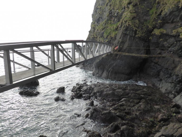
Co Antrim’s famous coastal path at The Gobbins is set to reopen next week on Tuesday 1 September. months after it was closed in the initial wave of coronavirus restrictions in Northern Ireland.

As RTÉ News reports, the cliff path — which was restored in 2015 after being closed for decades — has had a number of safety upgrades to allow for social distancing and hygiene standards to fight the spread of coronavirus.

Prebooking is also essential to allow for proper management of the popular Islandmagee attraction, renowned for its white-knuckle series of rugged steps, tunnels, caves and bridges.

Published in Coastal Notes

#MarineWildlife - Islandmagee locals are appealing to Northern Ireland's Environment Minister to add their waters to the list of recently proposed Marine Conservation Zones.

As the Belfast Telegraph reports, the call comes over fears that a planned Gaelectric gas power station could create a 'dead zone' in the North Channel caused by brine runoff from the plant.

Gaeletric maintains that even under a worst-case scenario, any impact of brine pumped into the sea on marine wildlife and plantlife would be low.

But the Islandmagee Community Residents Association argues that the development poses a threat to a "delicate and biodiverse" ecosystem in the area, which is home to vulnerable colonies of puffins as well as black guillemots and razorbills, among others.

As reported in December on Afloat.ie, Rathlin, Waterfoot, Outer Belfast Lough and Carlingford Lough were put forward for consideration as Marine Conservation Zones, the public consultation for which closed last Friday 11 March.

The Belfast Telegraph has more on the story HERE.
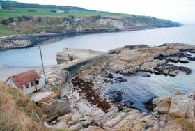
Published in Marine Wildlife

#Rescue - A woman is in stable condition in hospital after she was rescued from a sea cliff in Islandmagee on Tuesday (27 October) an operation that "wasn’t straightforward", as the News Letter reports.

It's believed the woman had been walking along the top coastal path when she got into difficulty late on Tuesday evening.

She was airlifted from the site by helicopter tasked from Scotland after being stabilised by paramedics.

The incident comes just weeks after emergency services rushed to the aid of an elderly man who fainted on the newly reopened Gobbins cliff walk in the same area.

The new cliff path has been hailed by the Guardian as "a reboot of a magnificent feat of engineering that originally opened in 1902", with local musical hero Michael Bradley of the Undertones writing about its heart-stopping mix of beauty and danger.

Published in Rescue

Ireland's offshore islands

Around 30 of Ireland's offshore islands are inhabited and hold a wealth of cultural heritage.

A central Government objective is to ensure that sustainable vibrant communities continue to live on the islands.

Irish offshore islands FAQs

Technically, it is Ireland itself, as the third largest island in Europe.

Ireland is surrounded by approximately 80 islands of significant size, of which only about 20 are inhabited.

Achill island is the largest of the Irish isles with a coastline of almost 80 miles and has a population of 2,569.

The smallest inhabited offshore island is Inishfree, off Donegal.

The total voting population in the Republic's inhabited islands is just over 2,600 people, according to the Department of Housing.

Starting with west Cork, and giving voting register numbers as of 2020, here you go - Bere island (177), Cape Clear island (131),Dursey island (6), Hare island (29), Whiddy island (26), Long island, Schull (16), Sherkin island (95). The Galway islands are Inis Mór (675), Inis Meáin (148), Inis Oírr (210), Inishbofin (183). The Donegal islands are Arranmore (513), Gola (30), Inishboffin (63), Inishfree (4), Tory (140). The Mayo islands, apart from Achill which is connected by a bridge, are Clare island (116), Inishbiggle (25) and Inishturk (52).

No, the Gaeltacht islands are the Donegal islands, three of the four Galway islands (Inishbofin, like Clifden, is English-speaking primarily), and Cape Clear or Oileán Chléire in west Cork.

Lack of a pier was one of the main factors in the evacuation of a number of islands, the best known being the Blasket islands off Kerry, which were evacuated in November 1953. There are now three cottages available to rent on the Great Blasket island.

In the early 20th century, scholars visited the Great Blasket to learn Irish and to collect folklore and they encouraged the islanders to record their life stories in their native tongue. The three best known island books are An tOileánach (The Islandman) by Tomás Ó Criomhthain, Peig by Peig Sayers, and Fiche Blian ag Fás (Twenty Years A-Growing) by Muiris Ó Súilleabháin. Former taoiseach Charles J Haughey also kept a residence on his island, Inishvickillaune, which is one of the smaller and less accessible Blasket islands.

Charles J Haughey, as above, or late Beatle musician, John Lennon. Lennon bought Dorinish island in Clew Bay, south Mayo, in 1967 for a reported £1,700 sterling. Vendor was Westport Harbour Board which had used it for marine pilots. Lennon reportedly planned to spend his retirement there, and The Guardian newspaper quoted local estate agent Andrew Crowley as saying he was "besotted with the place by all accounts". He did lodge a planning application for a house, but never built on the 19 acres. He offered it to Sid Rawle, founder of the Digger Action Movement and known as the "King of the Hippies". Rawle and 30 others lived there until 1972 when their tents were burned by an oil lamp. Lennon and Yoko Ono visited it once more before his death in 1980. Ono sold the island for £30,000 in 1984, and it is widely reported that she donated the proceeds of the sale to an Irish orphanage


Yes, Rathlin island, off Co Antrim's Causeway Coast, is Ireland's most northerly inhabited island. As a special area of conservation, it is home to tens of thousands of sea birds, including puffins, kittiwakes, razorbills and guillemots. It is known for its Rathlin golden hare. It is almost famous for the fact that Robert the Bruce, King of Scots, retreated after being defeated by the English at Perth and hid in a sea cave where he was so inspired by a spider's tenacity that he returned to defeat his enemy.

No. The Aran islands have a regular ferry and plane service, with ferries from Ros-a-Mhíl, south Connemara all year round and from Doolin, Co Clare in the tourist season. The plane service flies from Indreabhán to all three islands. Inishbofin is connected by ferry from Cleggan, Co Galway, while Clare island and Inishturk are connected from Roonagh pier, outside Louisburgh. The Donegal islands of Arranmore and Tory island also have ferry services, as has Bere island, Cape Clear and Sherkin off Cork. How are the island transport services financed? The Government subsidises transport services to and from the islands. The Irish Coast Guard carries out medical evacuations, as to the RNLI lifeboats. Former Fianna Fáíl minister Éamon Ó Cuív is widely credited with improving transport services to and from offshore islands, earning his department the nickname "Craggy island".

Craggy Island is an bleak, isolated community located of the west coast, inhabited by Irish, a Chinese community and one Maori. Three priests and housekeeper Mrs Doyle live in a parochial house There is a pub, a very small golf course, a McDonald's fast food restaurant and a Chinatown... Actually, that is all fiction. Craggy island is a figment of the imagination of the Father Ted series writers Graham Linehan and Arthur Mathews, for the highly successful Channel 4 television series, and the Georgian style parochial house on the "island" is actually Glenquin House in Co Clare.

Yes, that is of the Plassey, a freighter which was washed up on Inis Oírr in bad weather in 1960.

There are some small privately owned islands,and islands like Inishlyre in Co Mayo with only a small number of residents providing their own transport. Several Connemara islands such as Turbot and Inishturk South have a growing summer population, with some residents extending their stay during Covid-19. Turbot island off Eyrephort is one such example – the island, which was first spotted by Alcock and Brown as they approached Ireland during their epic transatlantic flight in 1919, was evacuated in 1978, four years after three of its fishermen drowned on the way home from watching an All Ireland final in Clifden. However, it is slowly being repopulated

Responsibility for the islands was taking over by the Department of Rural and Community Development . It was previously with the Gaeltacht section in the Department of Media, Tourism, Arts, Culture, Sport and the Gaeltacht.

It is a periodic bone of contention, as Ireland does not have the same approach to its islands as Norway, which believes in right of access. However, many improvements were made during Fianna Fáíl Galway West TD Éamon Ó Cuív's time as minister. The Irish Island Federation, Comdháil Oileáin na hÉireann, represents island issues at national and international level.

The 12 offshore islands with registered voters have long argued that having to cast their vote early puts them at a disadvantage – especially as improved transport links mean that ballot boxes can be transported to the mainland in most weather conditions, bar the winter months. Legislation allowing them to vote on the same day as the rest of the State wasn't passed in time for the February 2020 general election.

Yes, but check tide tables ! Omey island off north Connemara is accessible at low tide and also runs a summer race meeting on the strand. In Sligo, 14 pillars mark the way to Coney island – one of several islands bearing this name off the Irish coast.

Cape Clear or Oileán Chléire is the country's most southerly inhabited island, eight miles off the west Cork coast, and within sight of the Fastnet Rock lighthouse, also known as the "teardrop of Ireland".
Skellig Michael off the Kerry coast, which has a monastic site dating from the 6th century. It is accessible by boat – prebooking essential – from Portmagee, Co Kerry. However, due to Covid-19 restrictions, it was not open to visitors in 2020.
All islands have bird life, but puffins and gannets and kittiwakes are synonymous with Skellig Michael and Little Skellig. Rathlin island off Antrim and Cape Clear off west Cork have bird observatories. The Saltee islands off the Wexford coast are privately owned by the O'Neill family, but day visitors are permitted access to the Great Saltee during certain hours. The Saltees have gannets, gulls, puffins and Manx shearwaters.
Vikings used Dublin as a European slaving capital, and one of their bases was on Dalkey island, which can be viewed from Killiney's Vico road. Boat trips available from Coliemore harbour in Dalkey. Birdwatch Ireland has set up nestboxes here for roseate terns. Keep an eye out also for feral goats.
Plenty! There are regular boat trips in summer to Inchagoill island on Lough Corrib, while the best known Irish inshore island might be the lake isle of Innisfree on Sligo's Lough Gill, immortalised by WB Yeats in his poem of the same name. Roscommon's Lough Key has several islands, the most prominent being the privately-owned Castle Island. Trinity island is more accessible to the public - it was once occupied by Cistercian monks from Boyle Abbey.

©Afloat 2020