


Displaying items by tag: Labadie and Cockburn Banks
Survey By INFOMAR to Map Seabed South of Celtic Sea
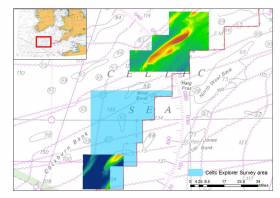
#MarineScience - Marine Institute's RV Celtic Explorer departed Galway yesterday for the first deepwater INFOMAR survey of 2018 to map the seabed in the region of the Labadie and Cockburn Banks, south of the Celtic Sea.
These areas are of ecological and economic value to the Irish fishing fleet and the data collected will allow better fisheries management decisions.
INFOMAR, the national seabed mapping programme, is a joint programme between the Geological Survey of Ireland (GSI) and Marine Institute. INFOMAR creates bathymetric charts and products for Ireland's coastal and deeper offshore waters using acoustic sonars called multi-beams. The survey team will be led by Vera Quinlan, and include four INFOMAR surveyors / scientists and four marine science students.
Three multi-beam echo sounders on the marine research vessel will transmit beams of sound towards the sea floor. These 'beams of sound' are reflected off the sea floor and both the time it takes to receive the returned signal and the intensity are captured by the on-board systems. This process provides a very clear picture of the shape and texture of the seafloor, such as the bathymetry, and the geological characteristics of the area.
Further studies include the analysis of the radiation patterns of the sonars resulting in increased precision and improved data. This is part of a long-running collaboration between INFOMAR and Professor John Hughes Clarke at the Centre for Coastal and Ocean Mapping at the University of NewINFOMAR survey to map the Celtic Sea seabed Hampshire.
The survey team includes two students from the United States of America, Alexandra Dawson and Treyson Gillespie, from the BEAMS (BEnthic Acoustic Mapping and Survey) Program. BEAMS is an undergraduate-focused training and research program from the College of Charleston's Department of Geology and Environmental Geosciences, and aims to develop a strong and qualified workforce of ocean surveyors in support of the academic, research and operational marine communities.
INFOMAR also welcomes Becky Cronin and Rachel O' Mahoney from the Training Through Research Surveys (TTRS), a collaboration with the Marine Institute. The programme aims to increase national capacity in offshore marine research by offering seagoing placements for students of marine related sciences and technologies on the national research vessels, RV Celtic Explorer and RV Celtic Voyager.
Follow INFOMAR on Facebook and Twitter for updates from the INFOMAR survey team. Also follow scientists@sea blog for some blogs during the survey.


, at the sod-turning event for the new Deep Water Quay Development at the Rossaveal Fishery Harbour Centre. (Forbairt Ché Dhomhain, Lárionad Chuan Iascaigh Ros An Mhíl) in February")

: helm Nathan Burke, station mechanic and coxswain Kieran ‘Colley’ O’Connell and helm Gary Hayes")
