


Displaying items by tag: Marina
#marinas – Dinny McGinley TD Minister of State at the Department of Arts, Heritage and the Gaeltacht welcomed the approval by his colleague Simon Coveney TD, Minister for Agriculture Food and Marine, of the development of a Small Craft Harbour at Killybegs Fishery Harbour Centre.
Welcoming this development Minister McGinley said "the proposed Small Craft Harbour will provide a safe and modern facility for current harbour users including small fishing boats, passenger and angling vessels and leisure craft. The new facility, when complete, will also provide short term berthage for visiting leisure craft."
"I have long been aware of the benefits of a marina at Killybegs Fishery Harbour Centre. As local representative for this area, I have down through the years read with interest a number of reports on Killybegs and the Fishery Harbour Centre in the past and the benefits for the local community that would accrue from such a development ."
The funding will be provided under the 2013 Fishery Harbour and Coastal Infrastructure Capital Development Programme to kick start the development of a Small Craft Harbour at Killybegs Fishery Harbour Centre.
Officials of the Department of Agriculture, Food and Marine will set out a design and strategy to build the Small Craft Harbour in stages to meet demand while remaining cognisant of the current funding constraints and to deliver the first phase at the earliest opportunity.
Koda The Husky Rescued By Quick-Thinking RNLI Crew
#RNLI - Two volunteer crew members from Kinsale RNLI came to the rescue of a husky dog who had a dramatic fall off a cliff near the Co Cork village recently.
Koda, a pedigree husky, was inspecting the coastline around Sandycove when she got too close to the edge and slipped over the 30ft cliff.
The dog landed in water with a strong current that swept her out to sea despite her desperate struggles to reach the shore. She managed to get herself back on a ledge by which time the alarm was raised and volunteer lifeboat crew were on their way.
A jagged reef also meant that Kinsale RNLI’s inshore lifeboat couldn't get close enough to help drag the struggling dog from the water.
However, Kinsale RNLI volunteers Nick Searls and Ian Fitzgerald were at the scene within minutes, and realised the danger facing the terrified dog.
Searles dived into the sea and swam over 60 metres to reach the animal. He managed to attach a harness and was able to swim slowly back to shore, dragging the weakened Koda with him. He was then assisted by safety line out of the sea by Fitzgerald.
Koda was immediately taken to a Kinsale vet, who confirmed that despite being exhausted and shocked by her ordeal, the dog was none the worse for wear.
In other news, Donaghadee RNLI assisted two men on board a yacht which got into difficulty off the Co Down coast yesterday morning (Tuesday 7 May).
The volunteer lifeboat crew was requested to launch at 9.50am by Bangor Coastguard to go to the aid of a yacht which had ran aground.
The 30ft yacht with two people on board had gone aground on rocks at the entrance to Donaghadee Marina.
With the help of another vessel, the lifeboat crew was quickly able to get a tow line to the yacht and pull it off the rocks.
The yacht, which had sustained some damage to its rudder, was able to make its way safely into the marina.
#marinas – It was only fifteen years ago that ocean voyager Paddy Barry set off in his much-travelled Galway Hooker St Patrick for a cruise round Ireland. He completed it, and he also succeeded in his secondary objective of seeing if it was still possible to do the circuit almost entirely without stops at anchorages described in detail in the Irish Cruising Club Sailing Directions.
By 1998, the Ireland circuit was no big deal, so you needed this frisson of exploration to add an extra zest. After all, Rob Henshall from Fermanagh had done the circuit unaccompanied in a Laser, and also alone on a windsurfer. But cruising boats were still so relatively rare on much of the Atlantic seaboard that it had been accepted that the ICC guides were bound to have gaps, as they relied almost exclusively on the voluntary input of information.
Then too, just fifteen years ago, the absence of convenient berthing and easy shore access was something else which made the more distant coastlines unknown places. And it wasn't in just the remoter areas that you had to face this problem. Even if you could manage to get comfortably anchored or moored, the business of getting ashore at anchorages on all coastlines could still be a struggle, much exacerbated if you had children or people with impaired mobility. For many Irish harbours, the minimal comfort and convenience of a landing pontoon was still an aspiration rather than the reality.
Back in 1995, Afloat Magazine first published a comprehensive Irish Marina Guide. It had to include all the inland waterways marinas to add the respectability of numbers, for the coastal marinas were still woefully few. And in a pre-prosperity Ireland in which the very name of "marina" aroused prejudice, new projects to provide a few berths in hostile harbours had to resort to euphemisms. "Boat Park" and "Convenience Berthing" and "Disabled Landing" were marinas by any other name. It was a case of whatever you're having yourself, any name you like, but just let's get on with it and have one, and try a taste of boating in late 20th Century style.
But now, things have certainly changed since the days you could cruise round Ireland and stay overnight in "unknown" anchorages. And a very encouraging number of harbours and anchorages have acquired the convenience and safety of a proper pontoon, where at the very least your crew can easily access your tender, and usually you can bring the boat alongside for short visits and the ease of getting gear, equipment and people directly on board.
Perhaps most interesting of all, however, is that marinas of all sizes - and happy to call themselves marinas - have appeared on nearly all coastlines, and sometimes in the most unexpected places, such that the Afloat.ie Marinas Guide currently lists 67 establishments, and we expect that number to steadily increase as the economy slowly revives. The realization of this enormous and welcome transformation is clearest when you study the recently-published 13th Edition of the Irish Cruising Club Sailing Directions for the South & West Coasts of Ireland.
When West Cork-based Norman Kean took over the job as Honorary Editor of the ICC's two pilotage books, he set out to make a round Ireland cruise like that of St Patrick in 1998 using only unknown anchorages, into an impossibility. It was a massively ambitious project, as Ireland's coastline measured in detail can be something like 4000 kilometres long.
But this Courtmacsherry Cyclone, ably assisted by his wife Geraldine, has worked miracles of research and productivity. Yet even by Norman Kean's high standards, this latest 13th Edition of the S & W book is a game changer, a masterwork, one of the best in the entire world, 356 pages of high quality information well amplified with clear plans, and profusely illustrated with photos all of which are informative and many - particularly the aerial ones by Kevin Dwyer - are beautiful evocations of an utterly lovely coastline which just occasionally we might too easily take for granted.
The previous 12th Edition was published in 2008, so obviously the difference is that projects which had only just been put in hand in the Celtic Tiger years are seen in this new book at various levels of fruition. If you find the memories of that crazy time depressing, cheer up. This book should encourage you to think that some lasting good – as with our excellent new motorway system – came out of that era of shared lunacy. While property values may have gone with the wind, the improvements to the coastal infrastructure are of lasting benefit which we can begin to enjoy properly as the economic wheels start to turn again.
Apart from its usefulness as an aid to navigation and pilotage, the 13th Edition a fascinating read in itself, as it takes you along two of our most interesting coastlines, and we get an insight into the way the various harbour authorities are seeking to embrace new opportunities. In several cases, it is County Councils which have been prepared to stick their heads above the marina development parapet.
High water in Dungarvan Harbour, and an impressive fleet is gathered at the sailing club's pontoon. Photo: Donal Walsh
For some years we saw on the east coast how Wicklow CC got dog's abuse from trying to do something useful with Greystones Harbour. But now that the marina is finally up and running with boats coming in and adding new life and interest to the place, it doesn't seem such a crazy idea after all.
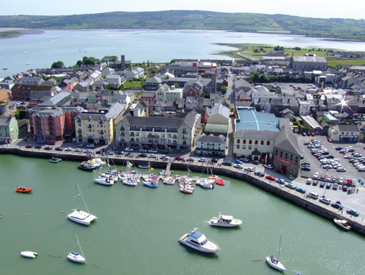
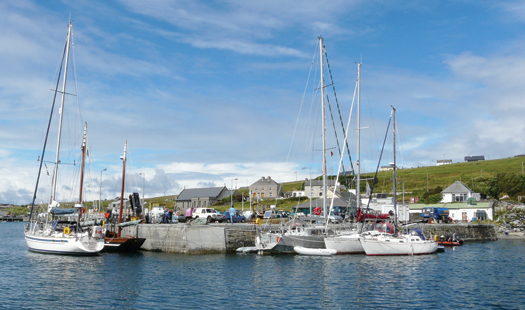
Last week in this blog we were discussing how Wexford County Council had brought vision and energy to the development of Kilmore Quay on the south coast, which these days is a national pace setter showing how best to combine different uses and sensibly utilise space. It was certainly a new era when the marina there was opened by all the top honchos in local authority and government nearly two decades ago. We probably still had a Department of the Marine back then, and it was such a time of hope, with the buzz at Kilmore so good, that though my mother-in-law's daughter and I had gone down expecting to return that same evening, it was well into the following afternoon when we reappeared at Command HQ.
Further west along the south coast, the new book has an intriguing aerial photo by Donal Walsh showing high water in Dungarvan Harbour, and the club pontoon well filled with yachts in regatta mode. For sure, it's a bit different when the tide goes out. But it's a useful reminder that the traditional perception of the coast between Waterford Estuary and Cork Harbour as a cruising desert is a complete nonsense.
Kinsale is almost a cliché for the perfect cruising port, but the 13th Edition makes us look at it anew with a Kevin Dwyer aerial pic which I hand't seen before, taken from due south. Properly speaking, West Cork is anywhere west of Cork city. But in reality West Cork doesn't properly begin until you're west of the Bandon River which flows through Kinsale Harbour. This photo says it all – the way that the crowded little town of Kinsale on the northeast side is a bustling cosmopolitan port, yet all you have to do is cross the bridge and immediately you're slowing down to West Cork speed and the relaxed atmosphere of Castlepark which – very welcome for families – even has its own neat little south-facing beach along a short sandy lane.
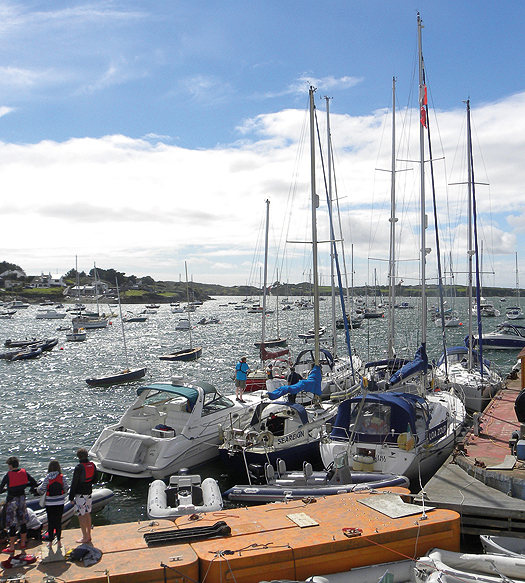
A brisk norwest wind makes things lively at Baltimore's crowded pontoon. In such conditions, there's much better shelter at the pontoon across at Sherkin Island. Photo: Edi Keating
Further west, busy Baltimore has battled for years to deal with conflicting demands on its limited public waterfront space. While the pontoon gives heroic service, in a brisk nor'wester it can verge on being very uncomfortable, and the photo by Edi Keating usefully illustrates that when conditions are like this, a sensible cruising crew will go over to the shelter at the Sherkin Island pontoon.
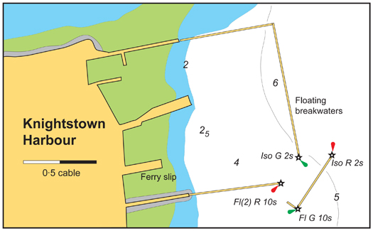
Around on the Kerry coast, there has been much activity with the floating breakwaters of a marina for Kerry County Council at Knightstown on Valentia Island. When eventually finished, it could have hundreds of berths, but for now it is considered permanent enough to be included in the new ICC book, and here it is for all to see – the longest landing pontoons in Ireland.
Paradise almost lost – the ruins of Paradise House are the last relics of ould dacency above the anchorage in the Fergus River Photo: Geraldine Hennigan
The anchorage at Paradise. Lt William Henn brought his hundred foot America's Cup-challenging steel cutter Galatea in here. Photo: Geraldine Hennigan
With its sluicing tides and acres of gooey mud, the Shannon Estuary is not to everyone's cruising taste, but Norman Kean was determined to do it from end to end. Among the islands at the mouth of the Fergus river on the north shore of the great estuary he found Paradise north of Kildysart – the remains of Paradise House, family home of 1886 America's Cup challenger William Henn, and the sweet little anchorage below it where the gallant Lieutenant Henn brought his hundred foot cutter Galatea for a visit.
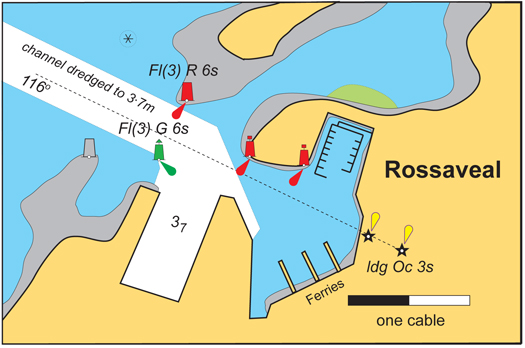
The marina at Rossaveal is already popular Photo: Geraldine Hennigan
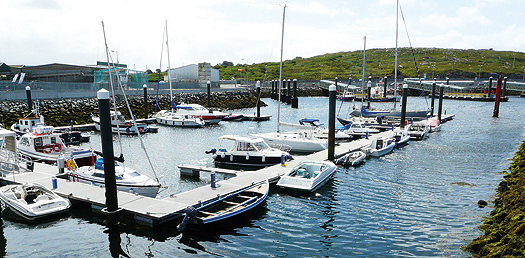
Up in Galway Bay, did you know there is now a marina at Rossaveal, that uber-busy Aran Islands ferryport and fishing harbour on the threshold of Connemara? Well, when they were doing the most recent re-development of Rossaveal, somebody did a bit of thinking outside the usual narrow box, and the result is a very handy little facility which already looks to be well filled, but there's room for more, and it's a very useful location.
The flotilla gathered at Inishbofin inner quay includes (left to right) the Arctic voyaging Arctic Fern (John Coyle), Dr Michael Brogan's ketch-rigged Galway hooker Mac Duach, the high latitudes cruiser Northabout (Jarlath Cunnane) and the Vancouver 28 Colla Voce (Pat Lavelle). Photo: Geraldine Hennigan
Of course, the dictating factor on any coastal marina is dealing with the ever present tides, but every cruising enthusiast likes to take a photo of their favourite little quayside in the convenience of high tide on a summer's day. Norman Kean has indulged the ICC's active western membership with a happy snap of some very distinguished boats rafted up at high water at the inner quay at Inishbofin, with Day's pub only a matter of yards away, and all well with the world until the tide falls. Even then, it's not the worst place to dry out alongside, and you'll note that Pat Lavelle's Vancouver 28 Colla Voce is a Bofin regular, and has a leg fitted.
Rosmoney's brand new pontoon. The boat is a 17ft French-designed pram built by Jarlath Cunnane Photo: Rory Casey
On up the coast, the new pontoon at Rosmoney Quay among the islands at the head of Clew Bay beside Mayo SC's well-filled anchorage was commissioned too late to be included in the new ICC book. But we have it here just to show that sometimes it is possible to draw level with the Kean machine, even if you never actually get ahead. MSC Commodore Rory Casey says that it's such a success they're going to have to be very careful that people don't hog it, but instead clear out just as soon as they've completed the essential tasks it's designed to facilitate.
Sligo has been a port seldom enough visited by cruising yachts. It's way off the beaten track if you're determinedly on the round Ireland circuit, and the two main sailing centres in the area – Rosses Point and Mullaghmore – have sometimes uncomfortable anchorages, Mullaghmore being open to the north, while the Rosses Point moorings are very tide rode.
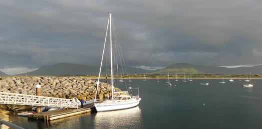
The pontoon in the heart of Sligo provides excellent access to an interesting town Photo: W M Nixon
But now there's a pontoon in Sligo itself, which is so handy that Darryl Hughes, the owner of the beautifully-restored 1937 43ft Tyrrell ketch Maybird, bases himself there when he makes his annual visit to the Yeats Summer School at the end of July. He's still the only Yeats aficionado who sails to the Summer School, but it's early days yet – the pontoon is still thought of as new.
Up the coast at Mullaghmore, they've worked a little miracle. The harbour is very much a drying basin, and the anchorage off it can be mighty lumpy. But with some judicious use of quite a lot of rock armour, they've created snug little corner just outside the harbour mouth and installed a fine big pontoon. The depth alongside may go down to 0.6 metres on the lowest tides, but most of the time most boats can nip alongside for convenient embarkation and unloading, and it's a major convenience and safety addition to the facilities of the harbour.
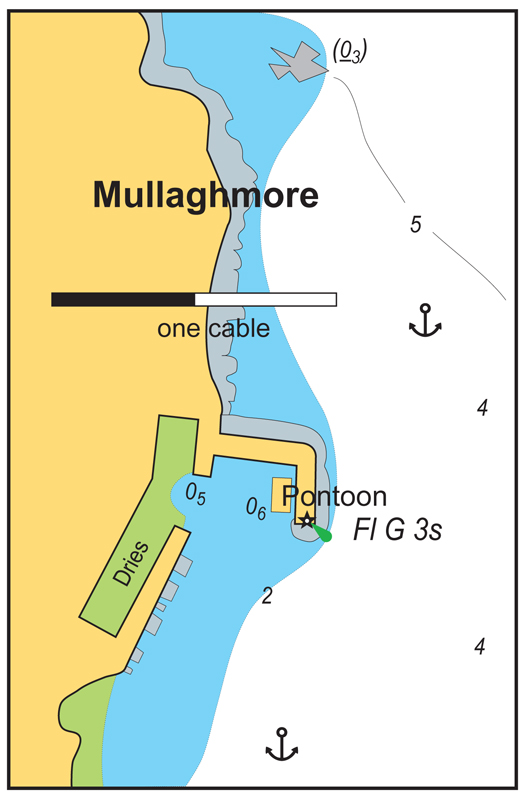
The new pontoon just outside the entrance to Mullaghmore Harbour is a boon for all boat users
From the head of Donegal Bay right round to Lough Swilly, there are some fine harbours, but there isn't another dedicated recreational boating pontoon until you get to Rathmullan in Lough Swilly, with Fahan Marina just across the way. It's only a matter of time before something is installed in Killybegs, and Burtonport up in that lovely area of The Rosses would be strategically useful and the logical place for some facility, ideally one where a boat could be left.
However, up there in that remotest corner of the remote northwest, one of my most convenient crew changes was done at the little fishing port of Kincasslagh. It must be the nearest port to Carrickfin airport, and that's very useful for crews linking to or from Dublin, for this place is cut off by the mountains from any direct roads. Time passes easily as you get up to speed with all the news of The Rosses at Iggy's bar in Kincasslagh, and if there's further delay you can always go and say hello to Daniel O'Donnell who lives nearby. He can tell you more Daniel O'Donnell jokes than anyone else, and tell them better too.
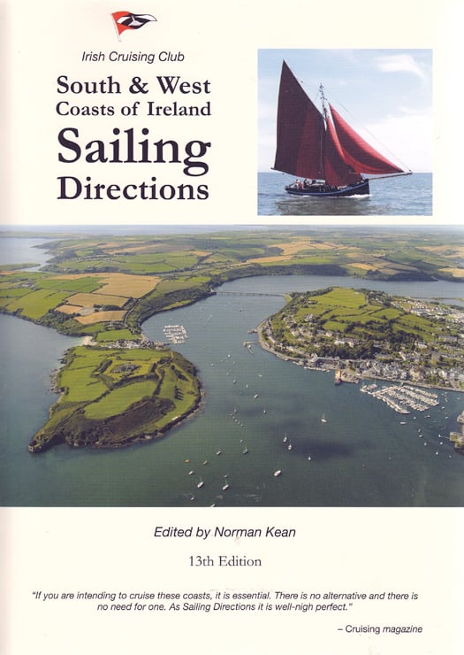
The 13th Edition of the Irish Cruising Club Sailing Directions for the South & West Coasts of Ireland is on sale at €29.95 from all good chandlers or bookshops, or direct from www.iccsailingbooks.com
Comment on this story?
We'd like to hear from you! Leave a message in the box below or email William Nixon directly on[email protected]
WM Nixon's Saturday Sailing blog appears every Saturday on Afloat.ie
Follow us on twitter @afloatmagazine and on our Afloat facebook page
Afloat's Marina Guide Online
We're keen to get reader input on their marina experiences too so we can build a comprehensive picture of the Irish coastal marina and pontoon scene. Can you update our readers with extra information? If so please leave your comments in the box provided for each marina/pontoon listed.
Grand Canal Marina, Dublin City. Yacht & Boat Berths in Dublin
The Grand Canal Marina in the inner dock of the Grand Canal Basin has a landmark 'Box in the Docks' building familiar to many Dubliners. The 50-berth facility opened in 2004 and has become an asset for boaters in the city centre especially during festivals such as the recent Tall Ships visits, permitting boating access and overnight stays (albeit via a sealock) in Dublin city.

Three Sisters Marina at New Ross in County Wexford is on the River Barrow and it is New Ross Town Council facility. It is nine miles up river from the confluence of the Suir and Barrow and it is 18 nautical miles from the sea at Hook Head.
The marina is a modern 66 berth facility. The marina has electrical shore power, mains water toilets and shower facilities. Alongside the marina is a major lift-out facility catering for vessels up to 50 tonnes.
The Marina Manager: John Dimond. The Email: [email protected]
Phone: 086 3889652 or 051 421284

The Royal St. George Yacht Club in Dun Laoghaire harbour offers fully serviced berthing for yachts up to 70ft with pontoons automatically lit and are equipped with shore power. Nightly rates are available. A security card service for visitors gives access to the Yacht Club.
Dun Laoghaire's National Yacht Club has a small pontoon facility with limited berthing for visiting yachts. The facility also has diesel, water, power and overnight facilities are available to cruising yachtsmen with shopping facilities being a short walk away
The club's pontoon is primarily used by its members for the short term securing of dry sailec boats prior to and after racing.
Boats dry-sailing from the platform and Club launches/RiB's have priority on the inside pontoons.
There is also a marked area for launches onto which no other vessel should berth.
Fuelling alongside may be arranged at non-racing times.
Boats may not remain overnight without the approval of the Club Boatman, unless arriving after service hours. The rate for berths are available from the club directly.
Dunmore East: A Suitable Harbour for a Marina?

Dunmore East is a charmingly located and picturesque coastal village, whose enormous potential as a holiday and maritime centre is blighted by having an outdated and rather drab industrial zone at its core. For it has the misfortune to be trapped in its historical position as a long-established fisheries port. This means that the administration of the harbour – which should be the pleasant heart of the village – has been rigidly strait-jacketed into serving and promoting the demands of the fishing industry, often to the exclusion and certainly the detriment of the possible needs of any other potential harbour users, both afloat and ashore.
Were Dunmore East located on another part of Ireland's coastline, this might not matter too much. But the village is a popular holiday resort, and the harbour is in an absolutely key strategic location at local, regional, national and international levels in recreational boating. It is at the heart of a fine sailing area which – if there were proper berthing facilities available – would be ideal for hosting major events. An immediate example is the ICRA Nationals. Dunmore East would be a perfect location for this national annual cruiser-racer championship, yet there's no way it will be considered until the harbour is more welcoming to recreational boating.
But not only is Dunmore a potential venue port, it is the gateway to the largely untapped cruising potential of Waterford Estuary, and the Suir, Barrow and Nore rivers. In any other country in the world, this beautiful cruising land of the Three Sisters would be perceived as a national treasure. But in Ireland it is still receiving only minimal attention because the key to the whole place, the gateway port of Dunmore East, has not been welcoming.
Dunmore East is both the heart of the coast, and the gateway to the magic cruising area of the Three Sisters - the estuaries of the Rivers Suir, Barrow and Nore. Photo: Google maps
Looking at the broader picture, Dunmore East's inhospitality affects the movement of cruising boats sailing along the coast. The large boat populations of the Irish Sea are discouraged from making the lengthy passage to the prime cruising areas of West Cork and Kerry because they're put off by knowing that if the urgent need arises, a visit to Dunmore East might not be a pleasant experience. Were the opposite the case, there would be an increase in the number of boats cruising the Irish coast generally. And a good experience in Dunmore East would also encourage them to sample the unexpected delights of cruising up to Waterford City or the port of New Ross, and visiting places little known to cruising men such as Duncannon, Arthurstown, Ballyhack and Cheek Point, not to mention the quiet anchorage behind Little Island in King's Channel.
One of the Waterford Estuary's little known anchorages is in Kings Channel behind Little Island immediately east of Waterford City. Photo: W M Nixon
But you get only one chance to make a favourable first impression, and in recent years Dunmore East has been failing to do that. One of the saddest things about the place is the Visitors Book in the hospitable Waterford Harbour Sailing Club. Time was when each summer would produce a long list of the crews of visiting boats from near and far, and their enthusiastic comments. But these days the list has reduced to a trickle as the increasingly hostile demands of the harassed fishing industry have made the harbour bad-tempered, a place to be avoided.
Yet just along the coast, 15 miles to the eastward beyond Hook Point, there's a smaller port which manages to be both a thriving fishing port, and a welcoming marina. Kilmore Quay misses almost all the natural advantages of Dunmore East, as it's on an exposed and rocky coast. But it has just about everything else that Dunmore East lacks – it has enthusiasm, visible hospitality, and a can-do approach for boats of all sorts. So though it has the disadvantage that once berthed there, there is little you can do except stay put if the weather deteriorates, in every other way Kilmore Quay is streets ahead.
This is surely because Kilmore Quay is owned and run by Wexford County Council. With a vigorous council, enthusiastic county managers, and an energetic harbour master whose brief extends well beyond the stultifying limitations of the Department of Fisheries, Kilmore Quay is very much alive, while Dunmore East is moribund.
This would be fine if Dunmore East continued to be a major fishing port, but that's now a moot point. Fishing is becoming more truly industrialized by the day, and big boats with highly automated equipment and smaller crews are taking over the most profitable parts of the business. A port like Dunmore East, with its small size and draft limitations, is increasingly by-passed by the major operators. For sure, there'll always be fishing out of Dunmore East, but with an inbuilt boat size limitation it will increasingly be towards the artisan end of the fishing industry.
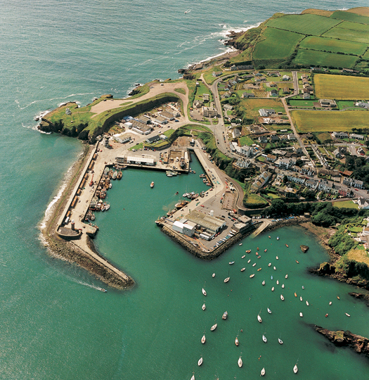
Dunmore East looking south, with Gull Rock lower right hand corner. In a southwesterly breeze, the anchorage is well sheltered, but it can become uncomfortable and even dangerous in southeast to east winds. Photo: Kevin Dwyer
Currently, Dunmore East has probably now slipped beyond fourth place in the Republic of Ireland in terms of fish landings by weight. You get the picture from the 2010 figures by realising that at 163,447 tonnes, Killybegs outstrips all other significant Irish ports combined. Next in line is Castletownbere with 19,030 tonnes, while Dingle is third at 12,761. Although in 2010 Dunmore East was fourth at 8,387 tonnes, in terms of value it was outstripped by Kilmore Quay – Dunmore's landings were worth €13.6m, but Kilmore went for quality, and they got €13.7m for their 3,260 tonnes.
And as Kilmore Quay has more in the way of fish processing plants, the value-added element to their smaller but higher quality catch is also greater than Dunmore East's. In Dunmore East, the continuing encroachment by the needs and expectations of the modern shore-based holiday market means that property is more profitably utilised if it's catering for the personalised needs of the hospitality industry, rather than as an impersonal industrial unit, particularly one with the anti-social aromas of fish processing.
This decline in the fishing industry status of the long-established smaller ports is a European-wide problem, and a new inititative from Brussels seems to offer an opportunity for Dunmore East to be a suitable case for treatment, as interestingly revealed HERE.
Although it all still requires confirmation from the European parliament, many of the EU's maritime nations such as Portugal are quite far down the line in planning projects which will take full advantage of this "post-fishing" scheme, which will involve some quite serious money to be available between 2014 and 2020.
But however obvious the benefits which could accrue to Dunmore East, the rejection by the locals of a major harbour improvement project some years ago (it was to include a marina) has muddied the waters for future projects. The older generation in Dunmore East probably reckon they've accommodated enough change. Though the present layout will seem to today's generations to be a permanent feature of the environment, there are still many around who can well remember the massive re-vamp of the harbour when it was being undertaken by the OPW during the 1960s. It was meant to take about five years, but it took eleven. And at the end of it, the pleasant little cove of Dunmore, sheltered by an elegant pier designed in 1814 by the harbour genius Alexander Nimmo, had been changed greatly, with a breakwater extension going out beyond the pier, while within there was an enormous new concrete apron quay on a site brutally blasted out of pretty cliffs. Despite which, the kittiwake, most unusually nesting on cliffs which had become a central part of the village, had stayed on despite a decade of dynamite.
The kittiwakes may have stayed on, but big fishing is going from Dunmore East. So how best to change the harbour for continuing viability, without destroying the much-loved character of the place, while at the same time profitably accomodating all possible harbour users?
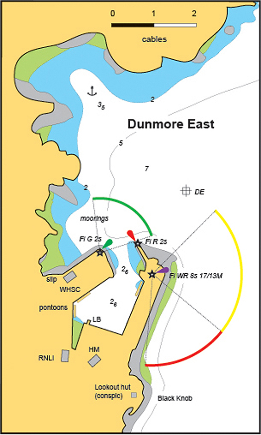
Dunmore East as it will be in the summer of 2013, with the new 40–metre pontoon indicated under the lighthouse on he outer pier. The anchor (top) indicates the anchorage in offshore winds off the Strand Hotel. Plan courtesy Irish Cruising Club
This year will see a small step towards providing berths for visiting cruisers. It's indicated on this latest ICC plan, and will be a 40 metre (120 feet) pontoon running lengthwise along the quay down towards the end of the pier, near the old lighthouse. Access ashore will be via steps that are let into the quay, and it's reckoned that up to twelve boats of average size can be accommodated. Every journey starts with a first step, but this particular first step by its location will require a lot of steps - in fact, route march is more like it - as it's about as far as you can be from the Sailing Club and the village without actually starting to depart from the harbour again.
Welcome as this pontoon is, there's a risk that it might serve as a distraction from more imaginative action, and already there is another quayside pontoon in the southwest corner of the harbour for Dunmore East's many half-deckers. But here at Sailing on Saturdays, we'd suggest that to be of any real value, Dunmore East harbour needs more radical action, and our harbour design department has been busy.
Any modification of Dunmore East harbour for use by craft of all sizes, and mostly smaller than today's average fishing boat, must take account of the fact that, in severe southeasterly gales, the outer parts of the harbour are extremely exposed. Up in the sandy cove off the Strand Hotel, where the ICC sailing directions quite rightly suggest anchoring if the wind is pleasantly between southwest and northwest, it is well known to YouTube viewers that a southeasterly gale (such as occurred on 15th August 2012) can produce impressive onshore breakers going clean over the inn. It's bad enough in a summer storm, and as for winter... in winter – when the traditional fishing season used to be at its height – Dunmore East could fill up with visiting Dutch boats, and after a period of severe southeasters the hotelier at The Strand went up to check his roof, and in the middle of it found a traditional Dutch wooden clog, swept in from the sea and popped up there by a mighty breaking wave.
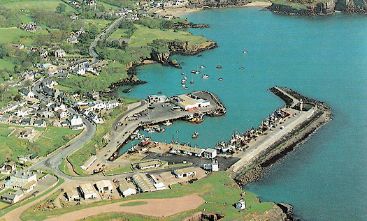
Dunmore East as seen from the southeast, with the Strand Hotel at top of photo. Photo: Rex Roberts
When the Strand Hotel is building up its clog collection in sou'east storms, there's quite a scend which can snake its war round the corner and into the harbour. And of course any yachts lying on the WHSC mooring immediately northwest of the harbour are having a very rugged time indeed. So the suggestion here is that we modify the harbour entrance to keep that scend at bay, and at the same time extend the Gull Rock through the current moorings to provide well sheltered space immediately northwest of the WHSC clubhouse.
The first step in this project would be lengthening the extension to the Outer Pier. Every time you see the place in rough weather, you can't help but think that the engineer in the 1960s would probably have liked to make it twice as long in the first place. But if we're going to have our new breakwater coming along the line of the Gull Rock, in order for it to be long enough to be effective without closing the harbour mouth too much, we have to angle the new outer breakwater extension in a slightly more northerly direction. Not much, but enough to make all the difference to the channel room in the harbour entrance.
The Gull Rock Breakwater is envisaged as being just that – a breakwater. It will have to be about a metre above High Water Springs, otherwise people will try to go over it as they do with the North Bull Wall in Dublin Bay. But the concept is that it's a breakwater and nothing more – no promenade along the top, and preferably made of rock armour to chime with the Gull Rock, though cost may make it necessary to build in tetrapods.
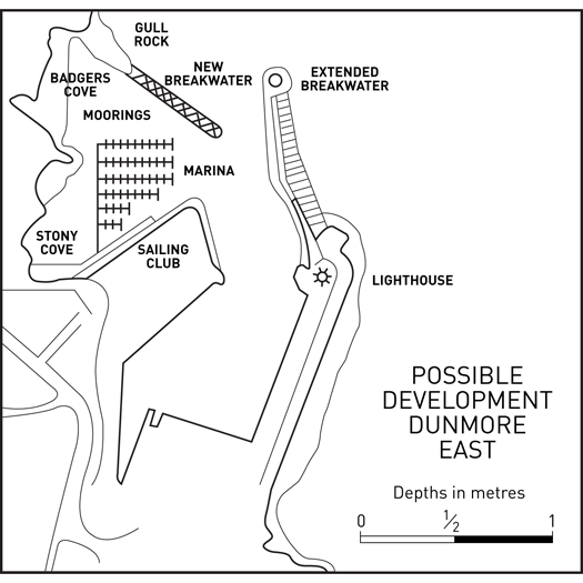
Thinking outside the box – Sailing on Saturday's line of thought for Dunmore East. The new breakwater suggested along the Gull Rock would simply be a breakwater, without a walkway along the top. Drawing by Afloat Studios.
With the extended outer pier and the new Gull Rock breakwater, a well-sheltered area is created for the installation of a marina. That's the beauty of a marina. All it needs is an area of sheltered water with the required depth, and just one single point of shoreside access. There's no need for expensively finished quay walls - a marina is a minimalist installation, and extremely good value once the space has been created.
We appreciate that there will be those who'll be horrified by the thought of any part of that pretty little coastline between the harbour and the Strand Hotel being enclosed behind a breakwater. But we'd emphasise that, as far as possible, the breakwater will be made to seem like a natural extension of the Gull Rock. And while Stony Cove and Badger's Cove will be within the new sheltered space, important locations like Men's Cove (Poul na Leenta) and Lady's Cove will be kept nice and fresh outside.
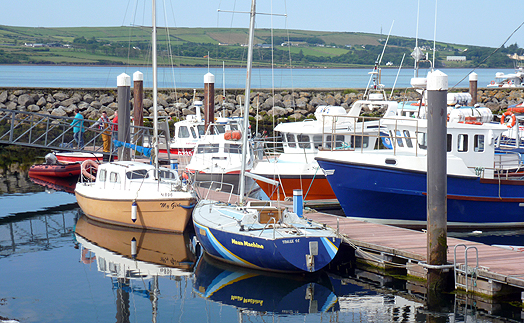
This newer marina for smaller local craft in Dingle suggests a welcome level of co-existence between all types. Photo: W M Nixon
With the marina in place, the entire dock area can revert to being exclusively for fishing boats. But with the industry being rationalized into a more compact shape these days, in time there could well be space for hauling out all boats and other manner of marine work taking place in there. Who knows, but maybe those pontoons running along the quays in the northeast and southwest corners of the harbour – a hugely wasteful use of quay space - might themselves become unofficial little marinas. I found one such in an eastern corner of Dingle Harbour last summer, and it seemed to be working in a harmonious way to accommodate boats of very different type and purpose.
Well, there you have it – it's one idea for Dunmore East, doubtless there are many others. And although Sir Boyle Roche may have quite rightly opined that we should do nothing for posterity on the grounds that posterity have done nothing for us, for the sake of future sailors let us at least take note that the clock in Brussels is ticking, and the train with these new funds will soon be leaving the station.
Comment on this story?
We'd like to hear from you! Leave a message in the box below or email William Nixon directly on [email protected]
WM Nixon's Saturday Sailing blog appears every Saturday on Afloat.ie
Follow us on twitter @afloatmagazine and on our Afloat facebook page
Rossaveal Marina, Connemara. Yacht & Boat Berths in Galway
Rossaveal (Ros a Mhil) marina is is situated in the heart of the Connemara Gaeltacht in County Galway. It was completed in 2011. The new facility involved the installation of pontoons and associated access bridge and services for the small craft harbour that can also accomodate the possible stopover of a Severn class RNLI lifeboat as well as large workboats. The facility is managed by the Dept. of Agriculture, Fisheries and Marine.
Rossaveal is the main ferry port for the Aran Islands in Galway Bay.

Foynes Yacht Club has a small pontoon facility at its base on the Shannon Estuary in County Limerick. The pontoon accommodates approximately eight visiting boats, four club boats, plus club rescue boats and up to 12 dinghies.
The club is located at Cooleen Point, Foynes, County Limerick, Ireland. Tel: +353 69 65261 Location: Latitude: 52°36"54' N Longitude: 09°06"484' W


")


