


Displaying items by tag: Poolbeg
Poolbeg Peninsula Project 'Vital to Deliver Capacity Required for Dublin Port by 2040' - Public Consultation Opens on 3FM Project
Dublin Port Company has today commenced formal public consultation on the 3FM Project, the third and final Masterplan project needed to complete the development of Dublin Port and bring it to its ultimate and final capacity by 2040.
The 3FM project is focused on Dublin Port lands on the Poolbeg Peninsula, on the south side of the bay and will deliver 20% of the capacity required by 2040. The Poolbeg peninsula already houses the greatest cluster of major utility operations in Ireland, with the largest wastewater works, the biggest waste-to-energy plant as well as power stations and part of the National Oil Reserve.
The 3FM project follows on from the first two Masterplan phases focused on the Port lands north of the bay – Alexandra Basin Redevelopment, which is nearing completion and MP2 which has recently commenced construction. All three are pillars of Dublin Port Company’s highly strategic approach to maximising Port capacity, which has been underway since 2010.
A computer-generated view of a new proposed opening bridge across the river Liffey as part of Dublin Port's 3FM Project. This new 190m bridge will link the north and south port areas and will include a 45m lifting section to the east of the Tom Clarke Bridge
This period of public consultation will be open until Friday, April 28th. It follows initial conversations in 2021 with key stakeholders and also a first round of public engagement in November 2021. Feedback from this led to a number of important changes to the initial plans. Since then, Dublin Port Company has been engaged in the preparation of detailed designs and environmental analysis ahead of lodging a planning application in summer 2023. This latest consultation phase will include a number of Public Information Days in Poolbeg, Ringsend and Clontarf where the Dublin Port team can discuss the plans with members of the local communities.
Details of the 3FM Project are available to view online here
Highlights of the 3FM Project
The project has seven main elements:
A new 2.2km road called the Southern Port Access Road (SPAR).
This will link the north and south port areas, and will include a 190m bridge, with a 45m lifting section to the east of the Tom Clarke Bridge. This will take heavy goods traffic off local roads by providing a dedicated route for port traffic as well as other heavy goods traffic on the Poolbeg Peninsula. The SPAR will have a substantial ‘active travel’ provision comprising cycle and pedestrian ways, as well as capacity for public transport to Poolbeg.
 at Dublin Port") A map of the Southern Port Access Road (SPAR) at Dublin Port
A map of the Southern Port Access Road (SPAR) at Dublin Port
 A computer-generated view of the SPAR Opening Bridge across the River Liffey
 A computer-generated view from SPAR looking East across the River Liffey
The development of the largest container terminal in Ireland in front of the ESB’s Poolbeg Power Station.
This terminal will have 650 metres of new deeper water berths at the east of the port and comprise a 9.1 hectare area for exports (Area N) at the waterside and a 5.9 hectare yard (Area O) on the southern side of the Poolbeg peninsula for imports. Altogether this terminal will have the capacity to handle 353,000 units (600,000 TEU) annually – more than twice the number of containers handled in all other ports in the country last year.
The relocation of container traffic to the east of the Port will allow the construction of a major new Ro-Ro terminal just north of the Sean Moore Roundabout.
This 12.6 hectare site will take trucks with containers (Roll On / Roll Off) for the increasing volumes of traffic coming directly from Europe post-Brexit. This terminal will add significantly to national strategic Ro-Ro capacity.
A new 325-metre ship turning circle in front of Pigeon House Harbour.
This has been the subject of extensive simulation modelling and will allow safe and efficient turning of 240m long ferries – the largest class of vessels.
A Utility Area
A 1 hectare to accommodate services provided by others, including the district heating system to be provided from the Covanta waste to energy plant and other services for the proposed residential developments in Poolbeg.
A new ‘Maritime Village’
a modern sailing and rowing campus which will provide enhanced facilities for a range of users, including sailing and rowing clubs, sea scouts, the Nautical Trust and local boat owners. The Maritime Village has been developed in consultation with local groups and will replace the current much smaller facilities as well as improving opportunities to view Port activities from the new waterside public plaza area.
Extensive Community Facilities
Including a 2.8 hectare Port Park and adjacent landscaped area, with 5G floodlit playing pitches and dog run. It will also see the provision of 5.5 km of active cycle and pedestrian paths throughout the Poolbeg peninsula which when linked to the planned active travel routes on the north side of the river will provide over 16km of cycle & pedestrian paths.
 A computer generated image of the Greenway at the front of the Port Centre
A Vital Project for Ireland
Dublin Port is the facilitator of economic growth in Ireland and the Masterplan is based on maximising Dublin Port’s capacity up to 2040. Dublin Port Company has previously highlighted that new port facilities will be needed elsewhere on the east coast to cater for increased port demand after that point. Without 3FM, Dublin Port would reach its capacity much earlier – perhaps by 2030, prompting the risk of a national port capacity shortage.
3FM is seen as a project of national strategic importance and it is mandated through Project Ireland 2040, National Ports Policy and as part of the National Development Plan 2021-2030.
It is expected that a planning application for 3FM will be made to An Bord Pleanála in summer 2023 and based on a start date in 2026, the target completion date for the overall project is 2039.
Port-City Integration
The 3FM project will deliver on the capacity objectives of Masterplan 2040 but it will also address an ongoing key objective of Dublin Port Company – the reintegration of the Port with Dublin City. Citizens will benefit from the 2.8 hectare Port Park and adjacent landscaped areas and improved access to the waterfront and Great South Wall, all linked by more than 5km of new and improved pedestrian and cycle routes. These will tie in with over 10km of greenways and active travel routes currently being built in the north port area, including the Liffey-Tolka Project.
Commenting on the 3FM project, Dublin Port Chief Executive Barry O’Connell said:
“We are very pleased to be progressing the 3FM project – which literally means “third and final” project of Masterplan 2040.
“Growth in volumes has been driven by a vibrant economy which has resulted in an increase in household consumption but also a hugely successful export sector. Exports now account for 40% of all movements through the port with at least some of the 60% of imports also comprising of raw materials later to be exported. With the value of exports up to 3.5 times that of imports it is clear to see how important the export sector is to the economy and indeed, how successful the State’s FDI strategy has been. Dublin Port, whilst having no direct influence on demand, has a critical role to play in facilitating this economic growth which is why the 3FM project is of critical importance as we look to a future of continued economic prosperity.
 Dublin Port CEO Barry O’Connell
Dublin Port will need to maximise capacity within its existing footprint for an annual throughput of 3.1 million trailers and containers by 2040. The 3FM project will deliver 20% of this capacity through the largest Lo-Lo terminal in Ireland – 353,000 containers per annum and a new Ro-Ro freight terminal – 252,000 freight trailers per annum.
“Dublin Port Company takes a generational approach to development at the Port – large infrastructure projects take up to 20 years from inception to completion. We know what we have to deliver on to enable Ireland’s growth up to 2040 and beyond and our expert team has been actively engaged in delivering the Masterplan for more than 10 years now. The ABR project is coming close to completion and we are pleased to have recently commenced the MP2 project on our northern lands.
“The Masterplan would be unable to progress without the support of all of our stakeholders and the early conversations in 2021 on 3FM, particularly with the statutory agencies, the major utilities already in Poolbeg and our local communities were extremely important in shaping our plans to this stage. We look forward to even greater engagement in the weeks ahead.
“Enhanced amenities for local citizens are central to our planning and the wonderful amenities at Port Park, the Maritime Village and all along the additional 5km of active travel routes will open up the waterside in new ways to Dubliners and help deepen understanding of the huge contribution the everyday work of the Port brings to enable all of our work and home lives. Port-City integration is a major objective of Dublin Port Company and 3FM will link in seamlessly with our other important projects in strengthening that vital connection between the Port and the people it serves”.
‘Lucky Opportunistic Shot’ Catches Lightning Strike on Poolbeg Chimneys in Dublin Bay
Twitter user Roger McMorrow captured an incredible video of lightning striking the iconic chimneys of the Poolbeg power station during a thunderstorm over Dublin Bay on Tuesday (19 July).
The clinical director and consultant anaesthetist at the National Maternity Hospital got the shot of a lifetime from the vantage of St Vincent’s Hospital in the south of the city.
Explaining his technique, Roger said: “For all those asking this was taken with an iPhone 12 on Slowmo propped up on a window sill.”
Lightning strikes #ESB #Poolbeg towers as seen from St Vincents Hospital this afternoon. ⛈ ⚡️ #thunder #Lightning #Dublin pic.twitter.com/Kh1Exyff6K
— Roger McMorrow ???? (@RogerMcMorrow) July 19, 2022
He added with modesty: “Just a lucky opportunistic shot”
Roger’s clip quickly went viral on social media — as did another photo purporting to show the same phenomenon from a different angle. But browsers beware, as the breathtaking shot appears to have been altered for dramatic effect.
Waves Crash Over Great South Wall at Poolbeg on Dublin Bay
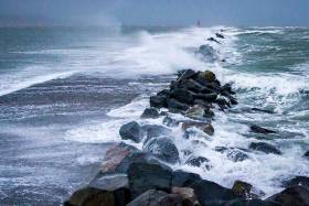
As Ireland braces itself for stormy conditions next week, photographer John Coveney captured waves breaking over the Great South Wall at Poolbeg on Dublin Bay during yesterday's Southeasterly Gale.
Met Eireann say South to southwest winds will continue to occasionally reach gale force 8 for a time this morning on Irish Coastal waters from Erris Head to Bloody Foreland to Fair Head.
The outlook for a further 24 hours until 0600, Sunday is for moderate to fresh west or southwest winds becoming southwesterly everywhere on Saturday afternoon. Winds veering west to northwest on south and west coasts late Saturday and early Sunday.
Rivers That Flow Through Our Cities Should Be Utilised
#thisislandnation – We don't make enough use of the rivers which flow through our cities. These ribbons of life to our major urban centres pass through the heart of the cities where the pressure of traffic and pedestrians shows more interest in the speed with which they can be crossed, often seeming to regard them as unwelcome blocks which require bridges, rather than appreciate that underneath those bridges is a system of transport and leisure which is neglected and often used by citizens for dumping of their waste.
There are some moves to utilise them more efficiently. On the Liffey there is a sightseeing tourist vessel and Poolbeg maintains its sailing presence close to the shipping sector. In Cork a voluntary organisation, Meitheal Mara, has promoted boating on the many different strands into which the city forces the Lee to pass through. Cork's city-based shipping operations have been diminished by the port which wants to end them altogether and move commercial shipping to Ringaskiddy where its public presence will be more limited and removed from the public eye. Waterford has based a marina in the city centre, but shunted its shipping to Belview where it is practically unseen by the public, so that the contribution of shipping to the economy is not perceived as strongly as it should be. Galway is a restricted tidal port, but a new one is planned and close enough to be seen by citizens. Dublin maintains port operations close to the city.
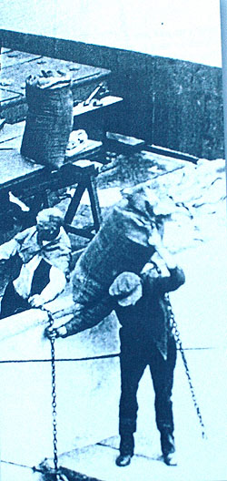
Dublin Port docker from the North Lotts book
There was a time when the ports and the rivers throbbed with life. In Dublin Guinness barges traversed the Liffey and there were real characters on the docks in all of our cities. Life could be tough as a dock labourer, but there was a great pride in the communities which lived around the ports and recognised the importance of shipping.
The East Wall has always been a proud Dublin community with seafaring a vital part of its tradition. On my programme THIS ISLAND NATION I played a song from a CD which was presented to me. 'Songs from the North Lotts' by Paul O'Brien capture a time in East Wall which deserves to be remembered. The East Wall Residents' Association which has been in existence for some fifty years, "maintaining and promoting the rare and wonderful community that it is an always has been," led the production of the book of the songs, dedicated to the people of East Wall and North Wall.
The song I played was "Taking the Boat," about which Paul O'Brien wrote in a book accompanying his CDs in 2009: "When I was growing up Dublin people didn't emigrate, they 'took the boat'. Single or married, it didn't matter. I don't personally know of any Dublin family that has not been touched by emigration."
There was a great response to the song, which you can hear on the Afloat website by CLICKING HERE. It was so good that in the June edition of the monthly programme, I will be playing another ballad from the collection – "Me Handsome Stevedore."
Tune in to hear it – next Wednesday night, June 4 at 7.30 pm on Youghal Radio – Community Radio Youghal 104FM or on their website www.cry104fm.com or if you are in the Dublin area, tune in to NearFM 90.3 on Friday night, June 6 at 6 p.m. This is another station joining the "family of the sea."
There was an interesting comment on the May edition of the programme by Jim O'Donovan, Director of Environment and Recreation with Cork City Council, who compared the better environmental condition of the River Lee to the Liffey, particularly around Heuston Station, about which he was quite critical.
Click HERE to listen to him on the Afloat podcast of the programme.
MARINE COMMUNITY GROWING
Waiting for the tide at Youghal in County Cork
Community radio stations around the country are showing great interest in the marine sphere and counteracting neglect by national and local commercial radio. I met many of these voluntary broadcasters at the annual meeting of their national organisation, CRAOL, over the past weekend in Youghal. They have produced and broadcast programmes on a wide variety of marine topics. THIS ISLAND NATION, was amongst the winners in the annual CRAOL national awards, chosen by the broadcasters themselves. I am pleased that the description "this island nation" is heard being more widely used in general conversation, by the media, in politics and in business. Awareness of the marine sphere is growing.
WHELKS, BIRDS AND FISHING
I didn't know a lot about the Irish sea snail which is worth around €4m. a year in exports until I talked to Liam Kennedy from the Sea Fisheries Protection Authority who wants fishermen to protect them. I will be broadcasting that interview in the June edition of THIS ISLAND NATION radio next week, as well as an exclusive interview with the Head of the SFPA, Susan Steele. She tells me that she wants to see "a thriving fishing industry and thriving fishing communities," but warns that those who "lose the run of themselves" and engage in illegal fishing will be dealt with speedily and effectively because they damage the future of the fishing industry. I will also be talking to Birdwatch Ireland about the arrival, for the first time, of one of the world's rarest sea birds off the Irish coast.
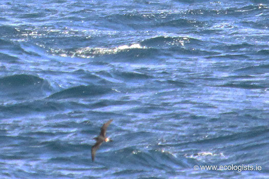
This is the Bermuda Petrel, an endangered species, of which there are only 108 breeding pairs known to exist.
WOMAN WITH CONFIDENCE
"We've never sailed in Cork before, but we're quite confident anyway." That's the view of the top woman match racing sailor, 32-year-old Camilla Ulrikkeholm from Denmark, who will be at the home of sailing, the Royal Cork YC in Crosshaven, for the ISAF Women's Match Racing World Championships will be staged there next week.
Camilla Ulrikkeholm from Denmark
The event will start on Tuesday and continue until Sunday, sailed in the ISA J80s fleet. "We've done a lot of research about the venue, we know the boat very well and we're definitely as tuned together as a crew should be. We'll just handle it the same way we usually do - arrive early to spend a day finding out all the practical details, then do some practising and get to know the boat and work our way into the regatta by using the first matches to learn about the local conditions."
That's confidence !
SHIPPING RECOVERY UNLIKELY
The Chief Executive of A.P.Moeller-Maersk Company has indicated that there will not be a sustainable recovery in the shipping industry in the short term. Nils Andersen is quoted as saying that "there is lingering overcapacity" which may remain until 2017. The Irish Maritime Development Organisation in its Weekly Market Review says that "the idle containership fleet" has gone below two per cent of the overall fleet for the first time since last September, but the global tanker market is experiencing low rates with the crude sector suffering particularly and providing only very low earnings for owners. The European Short Sea Bulk market is also experiencing a downward trend which has been developing since April.
BALTIMORE MARITIME COURSES
Baltimore Maritime Centre was formed in December 2013 by a nucleus of members of Les Glénans, following the closure of the Glenans sail training base in the village. It has acquired six of that organisation's keel boats and will start sailing courses this Summer in conjunction with Heir Island Sailing Schull and Baltimore Yacht Charters.
Twitter: @TomMacSweeney and @Afloatmagazine
Dublin Bay Oil, Gas, Coal...and Waste-Water!
The work is part of a Dublin City Council project to evaluate an extension at the Ringsend plant where treated water will be released into the bay. The council are conducting detailed feasibility studies which will be examined for an Environmental Impact Assessment.
To date the project has involved two other rigs, the Aran 250 and the larger Excalibur which remains in the bay. The barges will be towed to 20 pre-determined bore-hole locations in the bay where the jack-up rig barges operate 'legs' to sit on the seabed which enables a steady working platform. The rigs are operating on a continuous basis in an area covering most of Dublin Bay and close to the Burford Bank on the eastern fringes.
In addition a buoy will be positioned 300-metres of the barge during drill operations, which is expected to take approximately one week for each drill. For information on the location of the bore-holes, they can viewed from the Dublin Port website by clicking HERE The project is expected to be completed in late Spring.
Several support craft are engaged in the project that recently included the Seabed Worker, a 3,923 gross tonnes Norwegian anchor-handling tug supply vessel (AHTS) the tugs Multratug 7, MTS Valiant and Trojan and the RIB-craft sisters, Brian Boru and James Joyce which are on standby duties. Like the Trojan, the 12-seater RIBS are based at the Poolbeg Yacht Club Marina where in the tourist season the craft provide excursions in Dublin Bay for Sea Safari Tours. In October the project also required the services of the yellow-hulled catamaran, Xplorer to carry out a bathymetric survey of Dublin Bay. The larger tugs and rigs are based opposite in Alexandra Basin / Ocean Pier.
The largest drill-rig working to date on the project, the Excalibur arrived under the tow of the Multratug 7 on a misty morning on Christmas Day. Due to the weather conditions the red-hulled craft slipped quietly into the port. Several days later the imposing looking craft re-emerged with its six-towering jack-up 'sea-legs' that jutted skywards into an otherwise horizontal expanse of Dublin Bay.
The sight of the rig has presented many onlookers to mistakenly believe the drilling was for oil!...Not so but the assumption is not surprising given the reports last year of an oil-field discovery named the Dalkey Island Prospect. The name for the oil-field was referred to Dalkey, as the coastal suburb on the southern shores is the nearest landfall to the exploratory well sites at the Kish Bank Basin.
In fact this kind of exploratory activity was again to confuse residents throughout the bay when the drill-ship, Fugro Synergy was offshore at the Kish Bank between December 2009 and early Spring of 2010. Though on this occasion the search was not for oil but coal!
During this period the 5,200 tonnes vessel equipped with a drill-tower, seemed to be a near permanent feature on the horizon. A series of drill-wells up to 3,500-metres were conducted when the 2009 built ship was contracted to Irish based VP Power Ltd, to determine the commercial viability of extracting coal from the sea for generating electricity. The Underground Coal Gasification (UCG) project is a process where coal is heated in underwater rock reservoirs to extract gas, essentially converting gas-from-coal energy. Otherwise this method is commonly referred to as a 'clean' technology.
In addition to last year's search for deposits of large coal seams under the seabed, there was reports of a significant natural resource in the form of oil!... when several exploratory blocks again in the Kish Bank Basin were surveyed. The company behind this venture, Provident Resources, another Irish based exploration company, conducted initial oil surveys using air-born craft and as such no actual drill-based ships or rigs were used. Though should any oil flow, such an operation would be required.
Incidentally the Excalibur is designed also to perform offshore wind turbine installation work and is equipped with a 250-ton crane to hoist the wind-farm components. The vessel is operated by Fugro Seacore, a subsidiary of the Dutch parent company, Fugro, which also managed the drill-ship Fugro Synergy.
Poolbeg Yacht and Boat Club

Brief History of Poolbeg area
Poolbeg Yacht & Boat Club is adjacent to the Pigeon House coal burning electricity-generating station, which was officially closed in July 1976. It nestles at the foot of the towering twin stacks of the modern Poolbeg Power station, which replaced the Pigeon House in 1965. It is a site of considerable significance in the history of Irish technology close to the centre of Dublin.
There is an established walk close to the club. The South Wall of the Port of Dublin extends from Ringsend nearly four miles out into Dublin Bay. This is one of the longest sea-walls in Europe. The walk continues to the Half Moon bathing place. Further on is the landmark Poolbeg Lighthouse. The Poolbeg Lighthouse was built in 1768, but was re-designed and re-built into its present form in 1820.
Ringsend Village
There are different versions of the origin of the name Ringsend, but it is most probably derived from the Irish word Rinn meaning a point or spit of land jutting into the sea.
The area seems to have been relatively uninhabited up until the 1620s when a fishing station grew up around the end of a point jutting into the estuary among mudflats and salt marshes where the Liffey and Dodder met the sea.
A harbour was developed at Poolbeg and Ringsend replaced Dalkey as Dublin’s principal port.
From the mid-17th century hotels and lodging houses began to spring up to cater for the many sailors, soldiers, port officials and travellers passing through the area.
In 1654 the Chief Justice of Ireland, Henry Cromwell, ordered everyone of Irish blood to move two miles outside Dublin city and this led to the establishment of Irishtown.
By the turn of the century the population had increased significantly and a floating chapel was moored nearby to cater for the spiritual needs of the community. Work then began on St. Matthew’s church in Irishtown in the early 18th century, one of a number of ‘Mariners’ churches’ around Dublin Bay. Incidentally, the vaults of St. Matthew’s were reputedly used as a store for smuggled goods, smuggling being rife in the area during this period.
Throughout the 1700s travelling to and from Ringsend and Irishtown was risky, particularly after dark, as highwaymen and thieves roamed the surrounding countryside.
Press gangs also stalked the inns abducting people for the British Navy.
To make matters worse several bridges were swept away until the current granite structure was built after the flood of 1802 and the danger posed by the Dodder diminished after the construction of the reservoir at Glenasmole in 1868.
Fishing provided a good living for many, boat building, chemical works and other industries provided employment, and hot and cold seawater baths attracted day-trippers and longer-term visitors to Irishtown. Indeed Wolfe Tone often stayed in Irishtown to take a break from political activity.
The Great South Wall, including the Poolbeg lighthouse, was constructed throughout the 18th century to provide greater protection for vessels, and dredged soil from port improvements was used to form many streets on either side of the Liffey, the sites being apportioned by ‘lot’, hence the name South Lotts Road.
The Ballast Board was founded in 1786 to manage the port. This later became the Dublin Port and Docks Board, now called the Dublin Port Company Ltd.
The embankment of the quays was also completed during this period.
On the 23rd April 1796 a crowd of 60,000 people witnessed the opening of basins and sea-locks connecting the newly-built Grand Canal to the Liffey at Ringsend.
It was an astounding development, which equalled the entire Liverpool docks at the time and meant that Dublin was fast becoming the second port in Ireland and Britain.
However, an economic downturn followed the Act of Union in 1800 as restrictive tax laws were imposed. To compound matters, in 1818 the mail boats from Holyhead switched to Howth, later to a new terminal at Dún Laoghaire, while the Royal Dockyard was also removed.
The worst ravages of the 1845–47 famine were avoided in the Ringsend area due to the availability of fish and the importation of Indian corn by the local landlord, Sidney Herbert, and as the 19th century wore on the many industries such as glass and rope manufacturing, boatyards, mills and the new gasworks provided welcome employment.
In 1863 the Pembroke Township, consisting of Baggotrath, Donnybrook, Sandymount, Ringsend and Irishtown, was formed. Improvements in the following decades included a horse drawn tramline laid through the area in the early 1870s linking Nelson’s Pillar with the Martello Tower at Sandymount, and the construction of the sewage works in the 1880s. The Earl of Pembroke also provided funds for Ringsend Technical School, 1892, and the development of Pembroke Cottages, the first of a series of housing developments for workers, in 1893.
Around the turn of the century local Parish Priest Canon Mooney was a tireless worker on behalf of the local population, and was responsible for the rebuilding of St. Patrick’s church in the early 1900s.
During the 1916 Rising, Boland’s Mill on the Canal Docks was occupied by rebels under the command of de Valera. The flat complexes George Reynolds House and Whelan House are named for two local men who fought in the Rising, while O’Rahilly House is called after The O’Rahilly who was part of the GPO garrison.
In the 1930s the Pembroke Township was incorporated into Dublin city. Many changes have taken place in the intervening years including construction of new housing and the East Link Bridge, and the upgrading of Shelbourne Park Greyhound Stadium. The Dublin Docklands Development Authority is also now redeveloping a large site; a Village Improvement Scheme is being implemented for Ringsend; and Irishtown Stadium.
Dublin city based Poolbeg Yacht & Boat Club has completed developing its state of the art 100-berth marina facility in the heart of Ireland’s capital. Situated in Ringsend, a harbour area with a colourful maritime tradition stretching back to the 17th century, Poolbeg Yacht/Boat Club & Marina is in a prime location just 3kms from the cultural, historic, social and retail centre of Dublin.
The club has been welcoming locals and visitors alike for over thirty years. Members old and new, appreciate the friendly, family-oriented atmosphere of this highly sociable club.
The new 1.5 million euro marina development is a major new city attraction, particularly for visitors wishing to berth their vessels near the heart of Dublin and for Dublin based owners who like their vessels moored near the office for a quick getaway on Friday evenings! The marina also meets the international standards required to satisfy any yachtsperson who visits a European capital city
On-shore, the Poolbeg Yacht & Boat Club’s existing and new members, have benefited from the expansion and redevelopment of its clubhouse which has undergone a 500,000 euro dramatic facelift.
 The only Yacht/Boat Club & Marina in the heart of Dublin. A number of berths are available, depending on size, on an annual or six month basis. Berths are also available for visitors on a short-term basis.
Poolbeg Yacht/Boat Club & Marina offers a unique package to serious sailors, leisure-time enthusiasts or beginners alike:
* The only marina and club in the heart of Dublin
* 100 secure fully serviced berths for long and short term stays
* Welcoming and sociable
* Full club support and facilities
* All levels of sailing and training for adults and children
* Affiliated to the Irish Sailing Association
Poolbeg Yacht, Boat Club & Marina, South Bank, Pigeon House Road, Ringsend, Dublin 4. Tel: +353 1 668 9983, Fax: +353 1 668 7177, email: [email protected]
Have we got your club details? Click here to get involved


, at the sod-turning event for the new Deep Water Quay Development at the Rossaveal Fishery Harbour Centre. (Forbairt Ché Dhomhain, Lárionad Chuan Iascaigh Ros An Mhíl) in February")

