Menu

Ireland's sailing, boating & maritime magazine

Inland afloat headers


Displaying items by tag: Porpoises

#MarineWildlife - This weekend Dublin Port is deploying data buoys in Dublin Bay to monitor marine wildlife activity during the controversial dredging works at Alexandra Basin.

According to The Irish Times, the four boys will provide live data on any whales, dolphins or porpoises in the vicinity of the Burford Bank near Howth, where up to a million tonnes of dredge spoil will be dumped over the next few weeks.

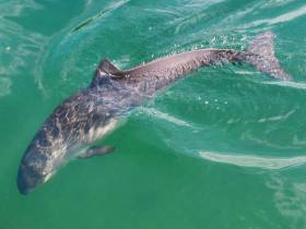
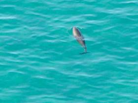
As previously reported on Afloat.ie, campaigners have raised concerns about the safety of Dublin Bay’s harbour porpoises, protected by an SAC since 2013, during the dredging operation.

The Irish Times has more on the story HERE.

Published in Dredging

#marinewildlife - Concerns have been voiced by campaigners about the safety of the Dublin Bay porpoise as Dublin Port commences dredging.

The Journai.ie writes that the Dublin Port Company (DPC) plan to remove up to a million tonnes of material from the port and dump it near Howth in order to keep the port deep enough for large naval vessels.

DPC says that the maintenance dredging process, which starts today, will last for between two to four weeks. Maintenance dredging is the periodic removal of sediments and is vital for many ports.

However, campaigners say that the waste material should not be dumped at DPC’s usual site near Howth. They are also fearful that porpoises could be harmed by the dredging vessel.

For more on the story click here. 

Afloat adds that a dredger from the UK is to arrive to the port tomorrow. 

Published in Dredging

#MarineWildlife - Dolphin and porpoise monitoring off the North Coast got a boost this week thanks to a £15,000 NI government grant for the Irish Whale and Dolphin Group (IWDG), as Causeway Coastal Community reports.

“This is good news for the IWDG and for those with a passion for marine wildlife," said Northern Ireland's Environment Minister Mark Durkan on funding for the acoustic monitoring project, which will focus on cetacean populations off Portrush and the nearby Giant's Causeway.

The project also includes an outreach programme with local schools and communities to get local people invested in the protection of marine wildlife on their shores. Causeway Coastal Community has more on the story HERE.

Minister Durkan is also the subject of calls to add the waters off Islandmagee to recently recommended Marine Conservation Zones for Northern Ireland over fears that a new gas power station could create a marine 'dead zone' in the area.

Published in Marine Wildlife

#MarineWildlife - How do whales, dolphins and porpoises hunt for fish? By using 'sound searchlights', according to Danish marine researchers.

As BBC News reports, the team of marine scientists at Aarhus University used underwater microphones to study the hunting behaviour of porpoises.

And they sound that the nimble cetaceans were able to adjust their echolocation abilities – using clicks and buzzes to navigate their surroundings – by switching from a narrow focus to a wide beam of sound as they closed in on their prey.

Scientists believe that other species of dolphins and whales also share this "exceptional" ability – which could provide the key to solutions that would prevent them getting trapped in commercial fishing gear.

BBC News has more on the story HERE.

Published in Marine Wildlife

#MarineWildlife - Marine scientists think they've found the answer to the mystery of dead porpoises washed up on French and Belgian beaches with dog-like bite marks.

As the Irish Examiner reports, their research points the finger at grey seals - forced into competition with the cetaceans over the fish that make up their diets.

Indeed, it may be overfishing by humans that's prompted the seals to turn on their fellow marine mammals as commercial fishing stocks dwindle in the North Sea.

The Irish Examiner has more on the story HERE.

Published in Marine Wildlife

#MarineWildlife - Minister for Arts, Heritage and the Gaeltacht Jimmy Deenihan announced on Wednesday the proposal of six new marine sites for designation as Special Areas of Conservation (SACs) to protect marine habitats and species listed on the 1992 EU Habitats Directive.


The six sites around the Irish coast represent habitats (sandbanks and reefs) and/or marine wildlife (specifically dolphins and porpoises) identified as insufficiently represented in the list of Irish SACs at the EU Commission's Marine Atlantic Biogeographic Seminar in 2009. These sites are:

  • Blackwater Bank, Co Wexford (Sandbank)
  • West Connacht Coast (Bottlenose dolphin)
  • Hempton’s Turbot Bank, Co Donegal (Sandbank)
  • Rockabill to Dalkey Island, Co Dublin (Reefs and harbour porpoise)
  • Porcupine Bank Canyon, off Kerry (Reefs)
  • South-East Rockall Bank (Reefs)


The designation of marine SACs is scheduled for completion in Europe in 2012, and according to the minister, this list of six additional SACs will constitute Ireland’s contribution to that process. 


In a statement, the department said: "These six SAC sites will protect a range of habitats and species including sandbanks, deep sea coral reefs, dolphins off the Atlantic coast and harbour porpoises found in Dublin Bay.

"These sites are part of a European network of nature conservation sites known as Natura 2000 which was established with the aim of preserving our rich natural heritage for future generations."


Among the new designations are two offshore sites at the Porcupine Bank Canyon and the South East Rockall Bank "contain excellent examples of offshore fauna associated with geogenic reef (ie reef made of rock). Considering the extent of Ireland’s offshore maritime area alongside the value and vulnerability of deep sea biodiversity therein, these two sites represent a modest but highly significant contribution to the Irish SAC network."

Two new inshore areas are being proposed in the west of Ireland to protect the bottlenose dolphin. The department is currently co-funding a multi-annual research programme to further understand the ecology of this species in this coastal region.

Meanwhile, the inshore site off Dublin from Rockabill to Dalkey Island is also being proposed both for the harbour porpoise, and for geogenic reef to address a gap in the SAC network for this habitat type in the northern part of the Irish Sea.

As previously reported on Afloat.ie, the oil exploration company behind the Dalkey Island Prospect has spoken out over the Rockabill to Dalkey Island designation, claiming it had not been given advance information of the decision.

Providence Resources says maps provided by the department appear to show and overlap between the location for a seismic survey and the new SAC area, which would make any development for resource extraction "extremely problematic".

Last week the Irish Whale and Dolphin Group (IWDG) expressed concern over the potential impact of the 2D seismic survey at Dalkey Island on harbour porpoises in Dublin Bay.

Published in Marine Wildlife

#MARINE WILDLIFE - Large numbers of dolphins have been filmed in the Irish Sea off the Welsh coast by wildlife volunteers, as WalesOnline reports.

The conservationists with the Sea Trust charity, based in Pembrokeshire, recorded the "dolphin-fest" from the deck of the Stena Europe ferry en route from Fishguard to Rosslare.

Sea Trust director Cliff Benson confirmed the sighting of "a pod of eight Risso's dolphins, 40-plus common dolphins [and] four porpoises" among others as soon as the ferry headed west of Tusker Rock.

Altogether in the three-hour passage across the Irish Sea, the volunteer surveyors recorded a total of 99 common dolphins, 10 Risso's dolphins and 26 harbour porpoises. "That's not bad for a winter trip," said Benson.

He added that while there are threats to the Irish Sea's cetaceans from scallop dredging and the like, "to date our surveys show this area is teeming with life.

“This is Wales and Ireland we are talking about not Bermuda so get this amount of dolphin and porpoise activity with whales thrown in as well is incredible."

Stena has welcomed Sea Trust volunteers on board its vessels since 2004 to check on cetaceans and other marine wildlife in the waters between Ireland and the UK on a monthly basis.

And as reported previously on Afloat.ie, Seatruck Ferries has also been providing free passage to UK marine wildlife researchers to discover how many dolphins and seabirds make their home in the Irish Sea.

Meanwhile, BBC News reports that a pod of more than 100 bottlenose dolphins was recently spotted off the Isle of Man.

The Manx Whale and Dolphin Watch said it received a number of sightings from the east and west coasts of the island in the northern half of the Irish Sea, reporting a hive of activity.

"The group sizes tend to be relatively ginormous," said Tom Felce of the group. "So if they are here you can't miss them."

Published in Marine Wildlife

#DALKEY ISLAND PROSPECT - The Irish Whale and Dolphin Group (IWDG) has joined the chorus of opposition to the proposed oil and gas exploration off Dalkey Island in Co Dublin.

As previously reported on Afloat.ie, Providence Resources has applied for a foreshore licence to search for oil or gas about 6km out to sea on the Kish Bank Basin.

But the prospect has provoked a split in the local community over the potential risks and benefits, with many calling for a public enquiry into the licence before it is granted.

This evening an urgent meeting in Dun Laoghaire will address the public's concerns, which have been echoed by the IWDG.

"The Kish Bank and adjacent waters are important for cetaceans," said the group in a statement. "In addition, sightings of bottlenose dolphins have increased dramatically in the area following the presence of a group of three individuals since August 2010."

The IWDG is concerned about the potential effects on dolphins and porpoises that "could due to noise generated from the drilling process", noting that "there is little published data on the intensity and effects of sound generated by drilling".

Protest group Protect Our Coast has launched a online petition against the Dalkey Island Prospect citing concerns over the proximity of the drilling area to the mainland as well as the Special Protection Area of Dalkey Island, which is a haven for marine wildlife.

Published in Coastal Notes

#MARINE WILDLIFE - A "feeding frenzy" involving a pod of fin whales was spotted off Hook Head in Co Wexford last week, The Irish Times reports.

And according to Andrew Malcolm of the Irish Whale and Dolphin Group (IWDG), two of the whales were in the same location almost exactly a year ago.

Malcolm, who was with a group on board the Rebecca C, used photographs of the whale's dorsal fins to compare records for the confirmation.

The pod of six fin whales was seen feeding some 3km southeast of Hook Head, attracted by the herring spawning grounds in the area.

More than 30 other cetaceans, including common dolphins, porpoises and a minke whale, were sighted on the trip.

The Irish Times has more on the story HERE.

Published in Marine Wildlife

Fastnet Line which runs the Cork-Swansea port route on the Celtic Sea, is assisting the charity MarineLife to monitor cetaceans, writes Jehan Ashmore.

The work of MarineLife is to survey the population trends and track the movements of dolphins, whales, porpoises and other wildlife. The research is undertaken onboard Fastnet Line's Julia (1981/21,699grt) and access to the ferry is provided free-of-charge to the wildlife-based charity.

During the months of July and August the ferry's schedule will allow for further opportunities to conduct daylight sightings of marine-life which is to be posted on MarineLife and Fastnet Line websites.

Adrian Shephard, Chairman of MarineLife Trustees, said: "The route from Swansea to Cork crosses a range of marine habitats and we hope it will generate many sightings of cetaceans and seabirds, including two important species we monitor, the white-beaked dolphin and the balearic shearwater".

In addition monitors recently observed fin whales, the second largest whale on the planet. Such sightings provide vital information and this will contribute to a better understanding of the distribution of cetaceans and other marine life in the Celtic Sea. To read more www.marine-life.org.uk

The first of four summertime surveys is to take place on 10 July. Overall the research by MarineLife is part of a larger project which also involves the use of other ferries operating in the Irish Sea and those serving on UK continental routes.

The 1,500 passenger / 325 car-carrying Julia sails year-round six times a week between September to June and from next month and during August the vessel will provide eight sailings per week. For fares and sailings schedules contact www.fastnetline.com

Published in Marine Science

General Information on using Waterways Ireland inland navigations

Safety on the Water

All users of the navigations are strongly recommended to make themselves aware of safety on the water for whatever activity they are involved in and to read the advice offered by the various governing bodies and by:

The Dept. of Transport, Ireland: www.gov.ie/transport and The Maritime and Coastguard Agency, UK, The RNLI – Water Safety Ireland for information in terms of drowning prevention and water safety.

Registration of Vessels

All vessels using the Shannon Navigation, which includes the Shannon-Erne Waterways and the Erne System must be registered with Waterways Ireland. Only open undecked boats with an engine of 15 horsepower or less on the Shannon Navigation, and vessels of 10 horsepower or less on the Erne System, are exempt. Registration is free of charge.

Craft registration should be completed online at: https://www.waterwaysireland.org/online-services/craft-registration

Permits for use of the Grand and Royal Canals and the Barrow Navigation

All vessels using the Grand and Royal Canals and the Barrow Navigation must display appropriate valid Permit(s) i.e A Combined Mooring and Passage Permit (€126) and if not intending to move every five days, an Extended Mooring Permit (€152).

Permit applications should be completed online at: https://www.waterwaysireland.org/online-services/canal-permits

Passage on the Royal and Grand Canals – Dublin Area

For boat passage through the locks east of Lock 12 into / out of Dublin on either the Royal or Grand Canals, Masters are requested to contact the Waterways Ireland Eastern Regional Office (M-F 9.30am-4.30pm) on tel: +353(0)1 868 0148 or email [email protected] prior to making passage in order to plan the necessary lock-keeping assistance arrangements.

On the Grand Canal a minimum of two days notice prior to the planned passage should be given, masters should note that with the exception of pre-arranged events, a maximum of 2 boats per day will be taken through the locks, travelling either east or west.

Movements in or out of the city will be organised by prior arrangement to take place as a single movement in one day. Boaters will be facilitated to travel the system if their passage is considered to be safe by Waterways Ireland and they have the valid permit(s) for mooring and passage.

Newcomen Lifting Bridge

On the Royal Canal two weeks’ notice of bridge passage (Newcomen Lifting Bridge) is required for the pre-set lift date, and lock assistance will then also be arranged. A minimum of 2 boats is required for a bridge lift to go ahead.

Waterways Ireland Eastern Regional Office (Tel: +353(0)1 868 0148 or [email protected] ) is the point of contact for the bridge lift.

A maximum number of boats passing will be implemented to keep to the times given above for the planned lifts (16 for the Sat / Sun lifts & 8 for the weekday lifts). Priority will be given on a first come first served basis.

On day of lift, boaters and passengers must follow guidance from Waterways Ireland staff about sequence of passage under bridge & through Lock 1, and must remain within signed and designated areas.

Events Held on the Waterways

All organised events taking place on the waterways must have the prior approval of Waterways Ireland. This is a twelve week process and application forms must be accompanied with the appropriate insurance, signed indemnity and risk assessment. The application should be completed on the Waterways Ireland events page at :

https://www.waterwaysireland.org/online-services/event-approval

Time Limits on Mooring in Public Harbours

On the Shannon Navigation and the Shannon-Erne Waterway craft may berth in public harbours for five consecutive days or a total of seven days in any one month.

On the Erne System, revised Bye Laws state that: No master or owner shall permit a vessel, boat or any floating or sunken object to remain moored at or in the vicinity of any public mooring, including mooring at any other public mooring within 3 kilometres of that location, for more than 3 consecutive days and shall not moor at that same mooring or any other public mooring within 3 kilometres of that location within the following 3 consecutive days without prior permission by an authorised official.

Winter Mooring on the Shannon Navigation and Shannon Erne Waterway

Winter mooring may be availed of by owners during the period 1 Nov to 31 Mar by prior arrangement and payment of a charge of €63.50 per craft. Craft not availing of Winter Mooring must continue to comply with the “5 Day Rule”. Winter Mooring applications should be completed online at : https://www.waterwaysireland.org/online-services/winter-moorings-booking

Owners should be aware that electricity supply and water supply to public moorings is disconnected for the winter months. This is to protect against frost damage, to reduce running costs and to minimise maintenance requirements during the winter months.

Vessel owners are advised that advance purchasing of electricity on the power bollards leading up to the disconnection date should be minimal. Electricity credit existing on the bollards will not be recoverable after the winter decommissioning date. Both services will be reinstated prior to the commencement of the next boating season.

Smart Cards

Waterways Ireland smart cards are used to operate locks on the Shannon Erne Waterway, to access the service blocks, to use the pump-outs along the navigations, to avail of electrical power at Waterways Ireland jetties.

Berthing in Public Harbours

Masters are reminded of the following:

  • Equip their vessel with mooring lines of appropriate length and strength and only secure their craft to mooring bollards and cleats provided for this purpose.
  • Ensure the available berth is suitable to the length of your vessel, do not overhang the mooring especially on finger moorings on floating pontoon moorings.
  • Ensure mooring lines, electric cables and fresh water hoses do not create a trip hazard on public jetties for others users.
  • Carry sufficient fenders to prevent damage to your own vessel, other vessels and WI property.
  • Allow sufficient space between your vessel and the vessel ahead /astern (c.1m) for fire safety purposes and /or to recover somebody from the water.
  • Do not berth more than two vessels side by side and ensure there is safe access/egress at all times between vessels and onto the harbour itself.
  • Do not berth in such a way to prevent use of harbour safety ladders, slipways or pump-outs.
  • Do not allow the bow of your vessel to overhang the walkway of a floating mooring thus creating a hazard for others with an overhanging anchor or bow fendering.
  • Animals are not allowed to be loose or stray at any time.
  • Harbour and jetty infrastructure such as railings, power pedestals, fresh water taps, electric light poles, safety bollards, ladders etc are not designed for the purpose of mooring craft , they will not bear the strain of a vessel and will be damaged.
  • At Carrybridge on the Erne System, Masters of vessels are not permitted to use stern on mooring. Masters of vessels must use the mooring fingers for mooring of vessels and for embarkation / disembarkation from vessels.

Passenger Vessel Berths

Masters of vessels should not berth on passenger vessel berths where it is indicated that an arrival is imminent. Passenger vessels plying the navigations generally only occupy the berths to embark and disembark passengers and rarely remain on the berths for extended periods or overnight.

Lock Lead-in Jetties

Lead-in jetties adjacent to the upstream and downstream gates at lock chambers are solely for the purpose of craft waiting to use the lock and should not be used for long term berthing.

Vessel Wake

Vessel wake, that is, the wave generated by the passage of the boat through the water, can sometimes be large, powerful and destructive depending on the hull shape and engine power of the vessel. This wake can be detrimental to other users of the navigation when it strikes their craft or inundates the shoreline or riverbank. Masters are requested to frequently look behind and check the effect of their wake / wash particularly when passing moored vessels, on entering harbours and approaching jetties and to be aware of people pursuing other activities such as fishing on the riverbank.

Speed Restriction

A vessel or boat shall not be navigated on the Shannon Navigation at a speed in excess of 5 kph when within 200 metres of a bridge, quay, jetty or wharf, when in a harbour or canal or when passing within 100 metres of a moored vessel or boat.

Vessels navigating the Shannon-Erne Waterway should observe the general 5 kph speed limit which applies along the waterway. This is necessary in order to prevent damage to the banks caused by excessive wash from vessels.

Vessels navigating the Erne System should observe the statutory 5kt / 6mph / 10kph speed limit areas.

A craft on the Royal and Grand canals shall not be navigated at a speed in excess of 6km per hour.

A craft on the Barrow Navigation shall not be navigated at a speed in excess of 11km per hour except as necessary for safe navigation in conditions of fast flow.

Bank Erosion

Narrow sections of all the navigations are particularly prone to bank erosion due to the large wash generated by some craft. Masters are requested to be vigilant and to slow down to a speed sufficient to maintain steerage when they observe the wash of their craft inundating the river banks.

Unusual Waterborne Activity

Unusual waterborne vessels may be encountered from time to time, such as, hovercraft or amphibious aircraft / seaplanes. Masters of such craft are reminded to apply the normal “Rule of the Road” when they meet conventional craft on the water and to allow extra room to manoeuvre in the interest of safety.

Sailing Activity

Mariners will encounter large numbers of sailing dinghies from late June to August in the vicinity of Lough Derg, Lough Ree and Lower Lough Erne. Sailing courses are marked by yellow buoys to suit weather conditions on the day. Vessels should proceed at slow speed and with due caution and observe the rules of navigation when passing these fleets, as many of the participants are junior sailors under training.

Rowing

Mariners should expect to meet canoes and vessels under oars on any part of the navigations, but more so in the vicinity of Athlone, Carrick-on-Shannon, Coleraine, Enniskillen and Limerick. Masters are reminded to proceed at slow speed and especially to reduce their wash to a minimum when passing these craft as they can be easily upset and swamped due to their very low freeboard and always be prepared to give way in any given traffic situation.

Canoeing

Canoeing is an adventure sport and participants are strongly recommended to seek the advice of the sport’s governing bodies i.e Canoeing Ireland and the Canoe Association of Northern Ireland, before venturing onto the navigations.

Persons in charge of canoes are reminded of the inherent danger to these craft associated with operating close to weirs, sluice gates, locks and other infrastructure particularly when rivers are in flood and large volumes of water are moving through the navigations due to general flood conditions or very heavy localised precipitation e.g. turbulent and broken water, stopper waves. Shooting weirs is prohibited without prior permission of Waterways Ireland.

Canoeists should check with lockkeepers prior entering a lock to ensure passage is done in a safe manner. Portage is required at all unmanned locks.

Canoe Trail Network – "Blueways"

Masters of powered craft are reminded that a canoe trail network is being developed across all navigations and to expect more organised canoeing along these trails necessitating slow speed and minimum wash when encountering canoeists, rowing boats etc

Rockingham and Drummans Island Canals – Lough Key

It is expected that work on Rockingham and Drummans Island Canals on Lough Key will be completed in 2021. Access to these canals will be for non-powered craft only, eg canoes, kayaks, rowing boats.

Fast Powerboats and Personal Watercraft (Jet Skis)

Masters of Fast Powerboats (speed greater than 17kts) and Personal Watercraft (i.e.Jet Skis) are reminded of the inherent dangers associated with high speed on the water and especially in the confines of small bays and narrow sections of the navigations. Keeping a proper look-out, making early alterations to course and /or reducing speed will avoid conflict with slower vessels using the navigation. Personal Watercraft are not permitted to be used on the canals.

Towing Waterskiers, Wakeboarders, Doughnuts etc

Masters of vessels engaged in any of these activities are reminded of the manoeuvring constraints imposed upon their vessel by the tow and of the added responsibilities that they have to the person(s) being towed. These activities should be conducted in areas which are clear of conflicting traffic. It is highly recommended that a person additional to the master be carried to act as a “look-out” to keep the tow under observation at all times.

Prohibition on Swimming

Swimming in the navigable channel, particularly at bridges, is dangerous and is prohibited due to the risk of being run over by a vessel underway in the navigation.

Age Restrictions on operating of powered craft

In the Republic of Ireland, Statutory Instrument 921 of 2005 provides the legal requirements regarding the minimum age for operating of powered craft. The Statutory Instrument contains the following requirements:

- The master or owner of a personal watercraft or a fast power craft shall take all reasonable steps to ensure that a person who has not attained the age of 16 years does not operate or control the craft

- The master or owner of a pleasure craft powered by an engine with a rating of more than 5 horse power or 3.7 kilowatts shall take all reasonable steps to ensure that a person who has not attained the age of 12 years does not operate or control the craft.

Lifejackets and Personal Flotation Devices (PFDs)

Lifejackets and PFD’s are the single most important items of personal protective equipment to be used on a vessel and should be worn especially when the vessel is being manoeuvred such as entering / departing a lock, anchoring, coming alongside or departing a jetty or quayside.

In the Republic of Ireland, Statutory Instrument 921 of 2005 provides the legal requirements regarding the wearing of Personal Flotation Devices. The Statutory Instrument contains the following requirements:

- The master or owner of a pleasure craft (other than a personal watercraft) shall ensure, that there are, at all times on board the craft, sufficient suitable personal flotation devices for each person on board.

- A person on a pleasure craft (other than a personal watercraft) of less than 7 metres length overall shall wear a suitable personal flotation device while on board an open craft or while on the deck of decked craft, other than when the craft is made fast to the shore or at anchor.

- The master or owner of a pleasure craft (other than a personal watercraft) shall take all reasonable steps to ensure that a person who has not attained the age of 16 years complies with paragraph above.

- The master or owner of a pleasure craft (other than a personal watercraft), shall take all reasonable steps to ensure that a person who has not attained the age of 16 years wears a suitable personal flotation device while on board an open craft or while on the deck of a decked craft other than when it is made fast to the shore or at anchor.

- The master or owner of a pleasure craft (other than a personal watercraft) shall take all reasonable steps to ensure that a person wears a suitable personal flotation device, at all times while – (a) being towed by the craft, (b) on board a vessel or object of any kind which is being towed by the craft.

Further information is available at: http://www.irishstatutebook.ie/eli/2005/si/921/made/en/print

Firing Range Danger Area – Lough Ree

The attention of mariners is drawn to the Irish Defence Forces Firing Range situated in the vicinity of buoys No’s 2 and 3, on Lough Ree on the Shannon Navigation. This range is used regularly for live firing exercises, throughout the year, all boats and vessels should stay clear of the area marked with yellow buoys showing a yellow "X" topmark and displaying the word "Danger".

Shannon Navigation, Portumna Swing Bridge Tolls

No attempt should be made by Masters’ of vessels to pay the bridge toll while making way through the bridge opening. Payment will only be taken by the Collector from Masters when they are secured alongside the jetties north and south of the bridge.

Navigating from Killaloe to Limerick on the Shannon Navigation

The navigation from Killaloe to Limerick involves passage through Ardnacrusha locks, the associated headrace and tailrace and the Abbey River into Limerick City. Careful passage planning is required to undertake this voyage. Considerations include: lock passage at Ardnacrusha, water flow in the navigation, airdraft under bridges on Abbey River in Limerick, state of tide in Limerick

Users are advised to contact the ESB Ardnacrusha hydroelectric power station (00353 (0)87 9970131) 48 hours in advance of commencing their journey to book passage through the locks at Ardnacrusha. It is NOT advised to undertake a voyage if more than one turbine is operating (20MW), due to the increased velocity of flow in the navigation channel, which can be dangerous. To ascertain automatically in real time how many turbines are running, users can phone +353 (0)87 6477229.

For safety reasons the ESB has advised that only powered craft with a capacity in excess of 5 knots are allowed to enter Ardnacrusha Headrace and Tailrace Canals.

Passage through Sarsfield Lock should be booked on +353-87-7972998, on the day prior to travel and it should be noted also that transit is not possible two hours either side of low water.

A Hydrographic survey in 2020 of the navigation channel revealed that the approach from Shannon Bridge to Sarsfield Lock and the Dock area has silted up. Masters of vessels and water users are advised to navigate to the Lock from Shannon bridge on a rising tide one or two hours before High Tide.

Lower Bann Navigation

The attention of all users is drawn to the “Users Code for the Lower Bann”, in particular to that section covering “Flow in the River” outlining the dangers for users both on the banks and in the navigation, associated with high flow rates when the river is in spate. Canoeists should consult and carry a copy of the “Lower Bann Canoe Trail” guide issued by the Canoe Association of Northern Ireland. Users should also contact the DfI Rivers Coleraine, who is responsible for regulating the flow rates on the river, for advisory information on the flow rates to be expected on any given day.

DfI Rivers Coleraine. Tel: 0044 28 7034 2357 Email: [email protected]

Lower Bann Navigation – Newferry – No wake zone

A No Wake Zone exists on the Lower Bann Navigation at Newferry. Masters of vessels are requested to proceed at a slow speed and create no wake while passing the jetties and slipways at Newferry.

Overhead Power Lines (OHPL) and Air draft

All Masters must be aware of the dangers associated with overhead power lines, in particular sailing vessels and workboats with cranes or large air drafts. Voyage planning is a necessity in order to identify the location of overhead lines crossing the navigation.

Overhead power line heights on the River Shannon are maintained at 12.6metres (40 feet) from Normal Summer level for that section of navigation, masters of vessels with a large air draft should proceed with caution and make additional allowances when water levels are high.

If a vessel or its equipment comes into contact with an OHPL the operator should NOT attempt to move the vessel or equipment. The conductor may still be alive or re-energise automatically. Maintain a safe distance and prevent third parties from approaching due to risk of arcing. Contact the emergency services for assistance.

Anglers are also reminded that a minimum ground distance of 30 metres should be maintained from overhead power lines when using a rod and line.

Submarine Cables and Pipes

Masters of vessels are reminded not to anchor their vessels in the vicinity of submarine cables or pipes in case they foul their anchor or damage the cables or pipes. Look to the river banks for signage indicating their presence.

Water Levels - Precautions

Low Water Levels:

When water levels fall below normal summer levels masters should be aware of:

Navigation

To reduce the risk of grounding masters should navigate on or near the centreline of the channel, avoid short cutting in dog-legged channels and navigating too close to navigation markers.

Proceeding at a slow speed will also reduce “squat” effect i.e. where the vessel tends to sit lower in the water as a consequence of higher speed.

Slipways

Reduced slipway length available under the water surface and the possibility of launching trailers dropping off the end of the concrete apron.

More slipway surface susceptible to weed growth requiring care while engaged in launching boats, from slipping and sliding on the slope. Note also that launching vehicles may not be able to get sufficient traction on the slipway once the craft is launched to get up the incline.

Bank Erosion

Very dry riverbanks are more susceptible to erosion from vessel wash.

Lock Share

Maximising on the number of vessels in a lock will ensure that the total volume of water moving downstream is decreased. Lock cycles should be used for vessels travelling each way.

High Water Levels:

When water levels rise above normal summer level masters should be aware of:

Navigation

Navigation marks will have reduced height above the water level or may disappear underwater altogether making the navigable channel difficult to discern.

In narrow sections of the navigations water levels will tend to rise more quickly than in main streams and air draft at bridges will likewise be reduced.

There will also be increased flow rates particularly in the vicinity of navigation infrastructure such as bridges, weirs, locks etc where extra care in manoeuvring vessels will be required.

Harbours and Jetties

Due care is required in harbours and at slipways when levels are at or near the same level as the harbour walkways' as the edge will be difficult to discern especially in reduced light conditions. It is advised that Personal Flotation Devices be worn if tending to craft in a harbour in these conditions.

Slipways

Slipways should only be used for the purpose of launching and recovering of water craft or other objects from the water. Before using a slipway it should be examined to ensure that the surface has sufficient traction/grip for the intended purpose such as launching a craft from a trailer using a vehicle, that there is sufficient depth of water on the slipway to float the craft off the trailer before the concrete apron ends and that the wheels of the trailer do not drop off the edge of the slipway. That life-saving appliances are available in the vicinity, that the vehicle is roadworthy and capable of coping with the weight of the trailer and boat on the incline. It is recommended that slipway operations are conducted by two persons.

Caution to be Used in Reliance upon Aids to Navigation

The aids to navigation depicted on the navigation guides comprise a system of fixed and floating aids to navigation. Prudent mariners will not rely solely on any single aid to navigation, particularly a floating aid to navigation. With respect to buoys, the buoy symbol is used to indicate the approximate position of the buoy body and the ground tackle which secures it to the lake or river bed. The approximate position is used because of the practical limitations in positioning and maintaining buoys in precise geographical locations. These limitations include, but are not limited to, prevailing atmospheric and lake/river conditions, the slope of and the material making up the lake/river bed, the fact that the buoys are moored to varying lengths of chain, and the fact that the buoy body and/or ground tackle positions are not under continuous surveillance. Due to the forces of nature, the position of the buoy body can be expected to shift inside and outside the charted symbol.

Buoys and perches are also moved out of position or pulled over by those mariners who use them to moor up to instead of anchoring. To this end, mariners should always monitor their passage by relating buoy/perch positions with the published navigation guide. Furthermore, a vessel attempting to pass close by always risks collision with a yawing buoy or with the obstruction that the buoy or beacon/perch marks.

Masters of Vessels are requested to use the most up to date Navigation guides when navigating on the Inland Waterways.

Information taken from Special Marine Notice No 1 of 2023