Menu

Ireland's sailing, boating & maritime magazine

Marine Notice: Surveys Off South & South West Coasts

19th June 2018
The VOS Sweet is conducting surveys off East Cork for the Celtic Interconnector project The VOS Sweet is conducting surveys off East Cork for the Celtic Interconnector project Credit: Shipspotting

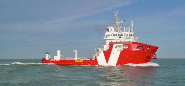
#MarineNotice - The survey vessel VOS Sweet (Callsign PCPE) is currently conducting offshore geotechnical and environmental survey operations associated with the proposed Celtic Interconnector on behalf of EirGrid.

The VOS Sweet was set to commence operations yesterday, Monday 18 June, and will operate on a 24-hour daily basis for approximately two weeks in two main corridors off East Cork to three landfall points: Ballinwilling Strand (Ballycotton Bay); Redbarn Beach and Claycastle Beach (Youghal Bay).

The survey is to collect geotechnical data utilising a Vibrocorer (VC) and Cone Penetration Test (CPT) spread and environmental (benthic) data utilising Grab Sampler spread. The survey will be conducted under Foreshore Licence FS006811. Common frequency VHF Channel 16 shall be used throughout the project.

Details of the route centreline co-ordinates as well as intended locations for the VC, CPT and benthic sampling are included in Marine Notice No 26 of 2018, a PDF of which is available to read or download HERE.

Meanwhile, Providence Resources is carrying out a site survey on its FEL 6/14 licence, called Newgrange, situated between the Southern Porcupine and Goban Spur Basins some 260km off the South West Coast.

The eight-day geophysical survey by the MV Kommandor (Callsign MCJO2), was scheduled to commence on Monday, is using dual-frequency side scan sonar, single-beam and multi‐beam echosounders, side scan sonar, sub‐bottom profilers and magnetometer.

Seabed (benthic) samples will also be taken using a box corer or grab as appropriate, and geotechnical sampling will be undertaken with a piston corer to a minimum target depth of 6m below the seabed.

In addition to the above, and to accurately determine potential future drilling hazards over the Newgrange location, the proposed survey will also include a high resolution 2D seismic which is not expected to exceed two days.

Survey operations will be conducted on a 24-hour basis. The MV Kommandor will be displaying shapes and lights prescribed in the International Rules for the Prevention of Collisions at Sea (COLREGS) Rule 27, to indicate that the survey vessel is restricted in its ability to manoeuvre. A listening watch will be maintained on VHF Channel 16, and the vessel will actively transmit an AIS signal.

Co-ordinates and a map of the expected working area are outlined in Marine Notice No 25 of 2018, a PDF of which is available to read or download HERE.

Published in Coastal Notes
MacDara Conroy

About The Author

MacDara Conroy

Email The Author

MacDara Conroy is a contributor covering all things on the water, from boating and wildlife to science and business

We've got a favour to ask

More people are reading Afloat.ie than ever thanks to the power of the internet but we're in stormy seas because advertising revenues across the media are falling fast. Unlike many news sites, we haven't put up a paywall because we want to keep our marine journalism open.

Afloat.ie is Ireland's only full-time marine journalism team and it takes time, money and hard work to produce our content.

So you can see why we need to ask for your help.

If everyone chipped in, we can enhance our coverage and our future would be more secure. You can help us through a small donation. Thank you.

Direct Donation to Afloat button

Coastal Notes Coastal Notes covers a broad spectrum of stories, events and developments in which some can be quirky and local in nature, while other stories are of national importance and are on-going, but whatever they are about, they need to be told.

Stories can be diverse and they can be influential, albeit some are more subtle than others in nature, while other events can be immediately felt. No more so felt, is firstly to those living along the coastal rim and rural isolated communities. Here the impact poses is increased to those directly linked with the sea, where daily lives are made from earning an income ashore and within coastal waters.

The topics in Coastal Notes can also be about the rare finding of sea-life creatures, a historic shipwreck lost to the passage of time and which has yet many a secret to tell. A trawler's net caught hauling more than fish but cannon balls dating to the Napoleonic era.

Also focusing the attention of Coastal Notes, are the maritime museums which are of national importance to maintaining access and knowledge of historical exhibits for future generations.

Equally to keep an eye on the present day, with activities of existing and planned projects in the pipeline from the wind and wave renewables sector and those of the energy exploration industry.

In addition Coastal Notes has many more angles to cover, be it the weekend boat leisure user taking a sedate cruise off a long straight beach on the coast beach and making a friend with a feathered companion along the way.

In complete contrast is to those who harvest the sea, using small boats based in harbours where infrastructure and safety poses an issue, before they set off to ply their trade at the foot of our highest sea cliffs along the rugged wild western seaboard.

It's all there, as Coastal Notes tells the stories that are arguably as varied to the environment from which they came from and indeed which shape people's interaction with the surrounding environment that is the natural world and our relationship with the sea.