Menu

Ireland's sailing, boating & maritime magazine

Displaying items by tag: S2S

Dun Laoghaire-Rathdown Councillor Barry Ward will be among the speakers at a public meeting in Dun Laoghaire later this month on the S2S (Sutton to Sandycove) coastal promenade and cycleway around Dublin Bay.

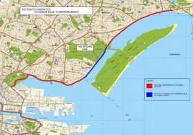
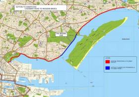
Long in the development stages, the S2S has been beset by planning snags and funding issues, and as yet only sections on the northern side of Dublin Bay between Sutton and Clontarf have been completed.

Michael Collins (S2S) and Clara Clark (Cycling Without Age) will also address the meeting at the Royal Marine Hotel on Tuesday 22 October from 7.30pm to discuss current and future moves on the project, including the €17.5 million allocated earlier this year for the section from Merrion Gates to Dun Laoghaire Harbour.

All are welcome to attend.

Tagged under

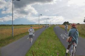
#Coastal - Planning permission has been granted for a new coastal cycle and walking path between Baldoyle and Portmarnock, as The Irish Times reports.

The new 1.8km path, which has much local support, will take cyclists off a narrow country road running between the two North Dublin suburbs.

It will also be in close proximity to the Sutton–Clontarf section of the S2S cycle route, and may be extended to both Sutton and Malahide in future.

The Irish Times has more on the story HERE.

Published in Coastal Notes
Tagged under

#S2S - The latest section of the Sutton to Sandycove (S2S) cycle route around Dublin Bay will not be opened till March due to delays on water main works, as Irish Cycle reports.

Once completed, the new cycle track — with mixed pedestrian and cyclist sections at junctions — will connect the pre-existing tracks between Sutton and the Bull Island causeway, and the route from Bull Bridge to East Wall Road.

As yet no section of the southside portion of the S2S has been completed, though a public consultation on the corridor from Sandymount/Merrion to Blackrock is currently open for public consultation till 31 January.

Irish Cycle has more on the story HERE.

Published in Dublin Bay

#DublinBay - An independent expert commissioned to evaluate local concerns over the new sea wall in Clontarf has recommended its height be reduced by at least 10 centimetres.

As previously reported on Afloat.ie, fears had grown among residents in the North Dublin Bay suburb that new flood defences constructed as part of the Sutton to Sandycove cycleway would exceed the height of the existing wall at the wooden bridge to the Bull Wall.

In response, Dublin City Council commissioned Dr Jimmy Murphy of University College Cork to examine the "technical information" that directed construction plans which residents claim breach previous promises over its maximum height and appearance.

But according to The Irish Times, while Dr Murphy's draft report says the wall's 4.25m height was "appropriate" in light of the council's long-term flood prevention criteria, there was no consistency as to the design plans and information used to inform such.

And for the time being, Dr Murphy suggests reducing the wall's "sea level rise" allowance by 10 to 20cm "at locations where the visual amenity is most affected".

The Irish Times has much more on the story HERE.

Published in Dublin Bay

Marine Protected Areas (MPAs) - FAQS

Marine protected areas (MPAs) are geographically defined maritime areas where human activities are managed to protect important natural or cultural resources. In addition to conserving marine species and habitats, MPAs can support maritime economic activity and reduce the effects of climate change and ocean acidification.

MPAs can be found across a range of marine habitats, from the open ocean to coastal areas, intertidal zones, bays and estuaries. Marine protected areas are defined areas where human activities are managed to protect important natural or cultural resources.

The world's first MPA is said to have been the Fort Jefferson National Monument in Florida, North America, which covered 18,850 hectares of sea and 35 hectares of coastal land. This location was designated in 1935, but the main drive for MPAs came much later. The current global movement can be traced to the first World Congress on National Parks in 1962, and initiation in 1976 of a process to deliver exclusive rights to sovereign states over waters up to 200 nautical miles out then began to provide new focus

The Rio ‘Earth Summit’ on climate change in 1992 saw a global MPA area target of 10% by the 2010 deadline. When this was not met, an “Aichi target 11” was set requiring 10% coverage by 2020. There has been repeated efforts since then to tighten up MPA requirements.

Marae Moana is a multiple-use marine protected area created on July 13th 2017 by the government of the Cook islands in the south Pacific, north- east of New Zealand. The area extends across over 1.9 million square kilometres. However, In September 2019, Jacqueline Evans, a prominent marine biologist and Goldman environmental award winner who was openly critical of the government's plans for seabed mining, was replaced as director of the park by the Cook Islands prime minister’s office. The move attracted local media criticism, as Evans was responsible for developing the Marae Moana policy and the Marae Moana Act, She had worked on raising funding for the park, expanding policy and regulations and developing a plan that designates permitted areas for industrial activities.

Criteria for identifying and selecting MPAs depends on the overall objective or direction of the programme identified by the coastal state. For example, if the objective is to safeguard ecological habitats, the criteria will emphasise habitat diversity and the unique nature of the particular area.

Permanence of MPAs can vary internationally. Some are established under legislative action or under a different regulatory mechanism to exist permanently into the future. Others are intended to last only a few months or years.

Yes, Ireland has MPA cover in about 2.13 per cent of our waters. Although much of Ireland’s marine environment is regarded as in “generally good condition”, according to an expert group report for Government published in January 2021, it says that biodiversity loss and ecosystem degradation are of “wide concern due to increasing pressures such as overexploitation, habitat loss, pollution, and climate change”.

The Government has set a target of 30 per cent MPA coverage by 2030, and moves are already being made in that direction. However, environmentalists are dubious, pointing out that a previous target of ten per cent by 2020 was not met.

Conservation and sustainable management of the marine environment has been mandated by a number of international agreements and legal obligations, as an expert group report to government has pointed out. There are specific requirements for area-based protection in the EU Marine Strategy Framework Directive (MSFD), the OSPAR Convention, the UN Convention on Biological Diversity and the UN Sustainable Development Goals. 

Yes, the Marine Strategy Framework directive (2008/56/EC) required member states to put measures in place to achieve or maintain good environmental status in their waters by 2020. Under the directive a coherent and representative network of MPAs had to be created by 2016.

Ireland was about halfway up the EU table in designating protected areas under existing habitats and bird directives in a comparison published by the European Commission in 2009. However, the Fair Seas campaign, an environmental coalition formed in 2022, points out that Ireland is “lagging behind “ even our closest neighbours, such as Scotland which has 37 per cent. The Fair Seas campaign wants at least 10 per cent of Irish waters to be designated as “fully protected” by 2025, and “at least” 30 per cent by 2030.

Nearly a quarter of Britain’s territorial waters are covered by MPAs, set up to protect vital ecosystems and species. However, a conservation NGO, Oceana, said that analysis of fishing vessel tracking data published in The Guardian in October 2020 found that more than 97% of British MPAs created to safeguard ocean habitats, are being dredged and bottom trawled. 

There’s the rub. Currently, there is no definition of an MPA in Irish law, and environment protections under the Wildlife Acts only apply to the foreshore.

Current protection in marine areas beyond 12 nautical miles is limited to measures taken under the EU Birds and Habitats Directives or the OSPAR Convention. This means that habitats and species that are not listed in the EU Directives, but which may be locally, nationally or internationally important, cannot currently be afforded the necessary protection

Yes. In late March 2022, Minister for Housing Darragh O’Brien said that the Government had begun developing “stand-alone legislation” to enable identification, designation and management of MPAs to meet Ireland’s national and international commitments.

Yes. Environmental groups are not happy, as they have pointed out that legislation on marine planning took precedence over legislation on MPAs, due to the push to develop offshore renewable energy.

No, but some activities may be banned or restricted. Extraction is the main activity affected as in oil and gas activities; mining; dumping; and bottom trawling

The Government’s expert group report noted that MPA designations are likely to have the greatest influence on the “capture fisheries, marine tourism and aquaculture sectors”. It said research suggests that the net impacts on fisheries could ultimately be either positive or negative and will depend on the type of fishery involved and a wide array of other factors.

The same report noted that marine tourism and recreation sector can substantially benefit from MPA designation. However, it said that the “magnitude of the benefits” will depend to a large extent on the location of the MPA sites within the network and the management measures put in place.

© Afloat 2022