Menu

Ireland's sailing, boating & maritime magazine

Displaying items by tag: PSE Kinsale Energy Limited

PSE Kinsale Energy Limited is undertaking an inshore pipeline survey along the route of a decommissioned pipeline from the Kinsale Gas Field.

Works will focus on the pipeline in the Celtic Sea close to Inch Beach in Co Cork.

The estimated duration of the survey is up to two days within a window from Friday 7 to Sunday 30 April, subject to weather and operational constraints.

Survey works will be conducted by the survey vessel Barnacle (callsign EIA2122) which will operate during daytime only and will display appropriate lights and signals.

Within the defined work areas, the vessel will be undertaking an acoustic survey using a multi-beam echo-sounder and a towed side-scan sonar.

All other vessels, particularly those engaged in fishing, are requested to leave a wide berth during the operations and to keep a sharp lookout in the relevant areas. The work vessel can be contacted on VHF Channel 13.

A map of the survey area, relevant coordinates and contact details are included in Marine Notice No 19 of 2023, attached below.

Published in Coastal Notes

Continuing its Kinsale area decomissioning project, PSE Kinsale Energy Limited advises that its Kinsale Head platform removal campaign will commence later this month and is expected to run through to September.

Works will be conducted by the semi-submersible, self-propelled crane unit Thialf (callsign 3EAA4) assisted by a number of cargo barges towed by the MV Kolga (callsign PCTR) and MW Bylgia (callsign PBMQ). The Merel G (callsign HO6511) will be used for crew transfer between the vessels and shore.

Backloading of removed compoents onto the cargo barges is planned for the offshore location but may be performed inshore depending on environmental conditions.

All work vessels may be contacted on VHF Channel 16 throughout the operation. All other vessels, particularly those engaged in fishing, are requested to give the vessels a wide berth and to keep a sharp lookout in the relevant areas.

Details of relevant coordinates and contact information can be found in Marine Notice No 24 of 2022, attached below.

Published in News Update

PSE Kinsale Energy advises that it is engaging in works to decommission subsea wells at the Southwest Kinsale, Seven Heads and Ballycotton gasfields from this week for the next eight months.

Weather depending, advance works were set to begin between today, Monday 22 and Wednesday 24 March ahead of the arrival of the work vessel Stena Spey next month.

Stena Spey (callsign GCWP) is a Mobile Offshore Drilling Unit (MODU) which will be first deployed to the Southwest Kinsale Gasfield for a period of some 90 days, where it will be positioned using eight pre-laid anchors, before moving on to the Seven Heads field.

Anchor handling vessels MV Maersk Maker (callsign OZGO2) and MV Maersk Marine (callsign OWGQ2) will accompany the Stena Spey throughout the well abandonment campaign.

Other work vessels of note are the ad-hoc anchor handling vessel MV Maersk Lancer (callsign OUHX2) and standby vessel MV VOS Pathfinder (callsign 2ALO7). All will listen on VHF Channel 16 throughout the operation.

Further details on the campaign, including the locations of rigs and anchor positions, are included in Marine Notice No 12 of 2021, a PDF of which can be downloaded below.

Published in News Update

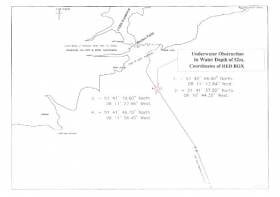
#MarineWarning - PSE Kinsale Energy Ltd advises that, that following a recent survey of the Kinsale Head Gas Field pipeline, it has identified a possible seabed obstruction off the South Coast of Ireland.

The nature of the obstruction, south-east of Roches Point on the approach to Cork Harbour, may present a hazard to ground fishing equipment, so any fishing vessels operating within the area are advised to proceed with caution.

Details of co-ordinates of the affected area are included in Marine Notice No 26 of 2017, a PDF of which is available to read or download HERE.

Published in Marine Warning

#MarineNotice - Sailors and other mariners off the South West Coast should keep on the lookout for a visual survey by remote operated vehicle currently being undertaken by PSE Kindle Energy Ltd.

The survey, which was set to commence on Tuesday 9 May, will run for the next three weeks in the environs of the Kinsale Head Gas Field, subject to weather conditions, and is being carried out from the Skandi Olympia (Callsign C6XY8).

The vessel will have an ROV deployed close to the seabed and its travel rate (survey rate) is approximately 0.4 knots over the ground on a weather-dependent heading.

Regular safety messages will be broadcast on VHF Channel 16. All vessels, and particularly those engaged in fishing, are requested to give the Skandi Olympia a wide berth and keep a sharp lookout in the revenant areas, as detailed in Marine Notice No 19 of 2017, a PDF of which is available to read or download HERE.

In case of any doubt, call the vessel on VHF and a safe course to follow will be given.

Published in Marine Warning

#NEWS UPDATE - The latest Marine Notice from the Department of Transport, Tourism and Sport (DTTAS) advises on a pipeline survey in the Celtic Sea next month.

PSE Kinsale Energy Limited will be commencing the survey of the 24" Gas Export Pipeline on 6 March 2012 using the Marine Institute vessel RV Celtic Voyager (call sign EIQN). The survey is expected to last 1 to 2 days, depending on weather conditions.

The survey will take place along the existing pipeline route in the Celtic Sea, between the shoreline at Inch Beach in Co Cork and gas platform 'Alpha'.

The RV Celtic Voyager will display appropriate lights and signals, and will be towing side scan sonar with cables of up to 200m long. A Radio Navigation Warning will be issued via the Irish Coast Guard (schedule Bravo, four times a day) prior to the vessel's arrival at the survey area. The vessel will also keep a listening watch on VHF Channel 16.

All vessels, particularly those engaged in fishing, are requested to give the RV Celtic Voyager and her towed equipment a wide berth and keep a sharp lookout in the relevant areas.

Further details for seafarers, including relevant co-ordinates, are included in Marine Notice No 7 of 2012, a PDF of which is available to read and download HERE.

Published in News Update

Marine Protected Areas (MPAs) - FAQS

Marine protected areas (MPAs) are geographically defined maritime areas where human activities are managed to protect important natural or cultural resources. In addition to conserving marine species and habitats, MPAs can support maritime economic activity and reduce the effects of climate change and ocean acidification.

MPAs can be found across a range of marine habitats, from the open ocean to coastal areas, intertidal zones, bays and estuaries. Marine protected areas are defined areas where human activities are managed to protect important natural or cultural resources.

The world's first MPA is said to have been the Fort Jefferson National Monument in Florida, North America, which covered 18,850 hectares of sea and 35 hectares of coastal land. This location was designated in 1935, but the main drive for MPAs came much later. The current global movement can be traced to the first World Congress on National Parks in 1962, and initiation in 1976 of a process to deliver exclusive rights to sovereign states over waters up to 200 nautical miles out then began to provide new focus

The Rio ‘Earth Summit’ on climate change in 1992 saw a global MPA area target of 10% by the 2010 deadline. When this was not met, an “Aichi target 11” was set requiring 10% coverage by 2020. There has been repeated efforts since then to tighten up MPA requirements.

Marae Moana is a multiple-use marine protected area created on July 13th 2017 by the government of the Cook islands in the south Pacific, north- east of New Zealand. The area extends across over 1.9 million square kilometres. However, In September 2019, Jacqueline Evans, a prominent marine biologist and Goldman environmental award winner who was openly critical of the government's plans for seabed mining, was replaced as director of the park by the Cook Islands prime minister’s office. The move attracted local media criticism, as Evans was responsible for developing the Marae Moana policy and the Marae Moana Act, She had worked on raising funding for the park, expanding policy and regulations and developing a plan that designates permitted areas for industrial activities.

Criteria for identifying and selecting MPAs depends on the overall objective or direction of the programme identified by the coastal state. For example, if the objective is to safeguard ecological habitats, the criteria will emphasise habitat diversity and the unique nature of the particular area.

Permanence of MPAs can vary internationally. Some are established under legislative action or under a different regulatory mechanism to exist permanently into the future. Others are intended to last only a few months or years.

Yes, Ireland has MPA cover in about 2.13 per cent of our waters. Although much of Ireland’s marine environment is regarded as in “generally good condition”, according to an expert group report for Government published in January 2021, it says that biodiversity loss and ecosystem degradation are of “wide concern due to increasing pressures such as overexploitation, habitat loss, pollution, and climate change”.

The Government has set a target of 30 per cent MPA coverage by 2030, and moves are already being made in that direction. However, environmentalists are dubious, pointing out that a previous target of ten per cent by 2020 was not met.

Conservation and sustainable management of the marine environment has been mandated by a number of international agreements and legal obligations, as an expert group report to government has pointed out. There are specific requirements for area-based protection in the EU Marine Strategy Framework Directive (MSFD), the OSPAR Convention, the UN Convention on Biological Diversity and the UN Sustainable Development Goals. 

Yes, the Marine Strategy Framework directive (2008/56/EC) required member states to put measures in place to achieve or maintain good environmental status in their waters by 2020. Under the directive a coherent and representative network of MPAs had to be created by 2016.

Ireland was about halfway up the EU table in designating protected areas under existing habitats and bird directives in a comparison published by the European Commission in 2009. However, the Fair Seas campaign, an environmental coalition formed in 2022, points out that Ireland is “lagging behind “ even our closest neighbours, such as Scotland which has 37 per cent. The Fair Seas campaign wants at least 10 per cent of Irish waters to be designated as “fully protected” by 2025, and “at least” 30 per cent by 2030.

Nearly a quarter of Britain’s territorial waters are covered by MPAs, set up to protect vital ecosystems and species. However, a conservation NGO, Oceana, said that analysis of fishing vessel tracking data published in The Guardian in October 2020 found that more than 97% of British MPAs created to safeguard ocean habitats, are being dredged and bottom trawled. 

There’s the rub. Currently, there is no definition of an MPA in Irish law, and environment protections under the Wildlife Acts only apply to the foreshore.

Current protection in marine areas beyond 12 nautical miles is limited to measures taken under the EU Birds and Habitats Directives or the OSPAR Convention. This means that habitats and species that are not listed in the EU Directives, but which may be locally, nationally or internationally important, cannot currently be afforded the necessary protection

Yes. In late March 2022, Minister for Housing Darragh O’Brien said that the Government had begun developing “stand-alone legislation” to enable identification, designation and management of MPAs to meet Ireland’s national and international commitments.

Yes. Environmental groups are not happy, as they have pointed out that legislation on marine planning took precedence over legislation on MPAs, due to the push to develop offshore renewable energy.

No, but some activities may be banned or restricted. Extraction is the main activity affected as in oil and gas activities; mining; dumping; and bottom trawling

The Government’s expert group report noted that MPA designations are likely to have the greatest influence on the “capture fisheries, marine tourism and aquaculture sectors”. It said research suggests that the net impacts on fisheries could ultimately be either positive or negative and will depend on the type of fishery involved and a wide array of other factors.

The same report noted that marine tourism and recreation sector can substantially benefit from MPA designation. However, it said that the “magnitude of the benefits” will depend to a large extent on the location of the MPA sites within the network and the management measures put in place.

© Afloat 2022