


Displaying items by tag: Megrim
Following the first and second legs in February and March, the third leg of this year’s Irish Anglerfish and Megrim Survey (IAMS 2024) is being carried out from Friday 12 to Sunday 21 April.
Surveys will be conducted to the North and North-West Coasts of Ireland by the Marine Institute in fulfilment of Ireland’s obligations under the Common Fisheries Policy (CFP).
Leg 3 is a demersal trawl survey consisting of approximately 50 otter trawls, each of 60 minutes duration, in ICES area 6a. Fishing in 2024 will take place within a three-nautical-mile radius of the positions indicated in Appendices 1 and 2 of Marine Notice No 12 of 2024, a PDF of which is attached below.
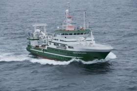
The survey will be conducted by the RV Celtic Explorer (callsign EIGB) which will display appropriate lights and signals. The vessel will be towing a Jackson demersal trawl during fishing operations.
The Marine Institute requests that commercial fishing and other marine operators keep a 3nm radius area around the tow points clear of any gear or apparatus during the survey period.
Further details are included in the Marine Notice below.
First Two Legs of Irish Anglerfish and Megrim Survey 2024 to Be Carried Out From Next Week
The first and second legs of this year’s Irish Anglerfish and Megrim Survey (IAMS 2024) will be carried out from Thursday 8 February to Sunday 3 March.
Surveys will be conducted to the West, South-West and South Coasts of Ireland by the Marine Institute in fulfilment of Ireland’s obligations under the Common Fisheries Policy (CFP).
IAMS is a demersal trawl survey consisting of approximately 110 otter trawls, each of 60 minutes duration, in ICES areas 7b, 7c, 7g, 7h, 7j and 7k.
Fishing in 2024 will take place within a three-nautical-mile radius of the positions indicated in Appendices 1 and 2 of Marine Notice No 03 of 2024, a PDF of which is attached below.
The survey will be conducted by the RV Celtic Explorer (callsign EIGB) which will display appropriate lights and signals. The vessel will be towing a Jackson demersal trawl during fishing operations.
The Marine Institute requests that commercial fishing and other marine operators keep a 3nm radius area around the tow points clear of any gear or apparatus during the survey period.
Further details are included in the Marine Notice below.
2018 Anglerfish & Megrim Survey Begins Today
#MarineNotice - The Marine Institute’s annual Irish Anglerfish and Megrim Survey (IAMS) for 2018 is scheduled to resume today, Tuesday 10 April.
After January's survey off the West and South Coasts, this month's survey will be carried out till Saturday 21 April off the North and North West Coasts of Ireland in fulfilment of Ireland’s Common Fisheries Policy obligations.
The IAMS is a demersal trawl survey consisting of approximately 50 otter trawls of 60 minutes duration in ICES area 6a. Fishing will take place within a three nautical mile radius of the positions indicated in Marine Notice No 15 of 2018, a PDF of which is available to read or download HERE.
Survey operations will be conducted by the RV Celtic Explorer (Callsign EIGB), which will display all appropriate lights and signals during the survey and will also be listening on VHF Channel 16.
The vessel will be towing a Jackson demersal trawl during fishing operations. The Marine Institute requests that commercial fishing and other marine operators keep a three nautical mile area around the tow points clear of any gear or apparatus during the survey period outlined above.
Specifics of any fishing gear or other obstructions that are known and cannot be kept clear of these survey haul locations can be notified using the contact details provided in the Marine Notice.
Marine Notice: Annual Monkfish & Megrim Survey

#MarineNotice - The latest Marine Notice from the Department of Transport, Tourism and Sport (DTTAS) advises that the Marine Institute is carrying out its annual Irish anglerfish and megrim survey (IAMS 2017) in fulfilment of Ireland’s Common Fisheries Policy obligations from this Tuesday 14 February to Friday 17 March.
The IAMS is a demersal trawl and beam trawl survey consisting of around 85 otter trawls (60 minutes) and 25 beam trawls (30 minutes) in International Council for Exploration of the Sea (ICES) area 7b, 7c, 7g, 7h, 7j and 7k off the West, South West and South Coasts.
Fishing in 2017 will take place within a three-nautical-mile radius of the positions indicated in Marine Notice No 5 of 2017, a PDF of which is available to read or download HERE.
The survey will be conducted by the RV Celtic Explorer (Callsign EIGB), which will display all appropriate lights and signals during the survey and will also be listening on VHF Channel 16.
The vessel will be towing a Jackson demersal trawl or two 4m beam trawls during operations. The Marine Institute requests that commercial fishing and other marine operators to keep a 3nm area around the tow points clear of any gear or apparatus during the survey period outlined above.
While there is no statutory provision for the loss of gear at sea, the Marine Institute will make every effort to avoid gear adequately marked according to legislation that may be encountered in the notified areas.
In the event that an operator has static gear or other obstructions within 3nm of the points listed, it is the responsibility of the owner to notify the survey managers or vessel directly.
This should be communicated by identifying specifically which ‘station’ is of concern using the appendix and contact details provided in the Marine Notice. It is not required to provide positional details of commercial operations beyond 4nm of the survey points provided.
Specifics of any fishing gear or other obstructions that are known and cannot be kept clear of these survey haul locations can be notified using the contact details provided.


: helm Nathan Burke, station mechanic and coxswain Kieran ‘Colley’ O’Connell and helm Gary Hayes")
 is the popular overall winner of the Lambay Lady, top trophy in Howth YC’s Wave Regatta")

