


Displaying items by tag: Rockall
Rockall Record Gets Frank Kowalski Afloat.ie 'Sailor of the Month' Special Award for July
The very special powerboats of SafeHaven Marine in East Cork have multiple uses, but high speed potential in a wide variety of sea conditions is invariably top of a list of very demanding priorities among the highly-regarded company’s prestigious customers.
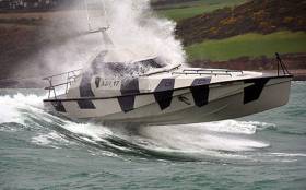
So when the notion of a Round Ireland and Rockall Powerboat Record first surfaced, inevitably it came from the fertile and visionary mind of SafeHaven’s Frank Kowalksi. And in July, his latest Youghal-built creation Thunder Child took on the 2000-plus kilometres challenge, going anti-clockwise and using refuelling stops at Portrush in County Antrim on the outward passage from the start/finish point of the Old Head of Kinsale, and Ballyglass on Broadhaven in Mayo on the return.
While conditions were favourable, in July’s unsettled weather there were bound to be some distinctly bumpy stages on such a long and exposed course, while many sections near land were notably tide-riven. Yet despite this, Thunder Child came back in round the Old Head of Kinsale on the evening of July 5th just 34 hours one minute and 47 seconds after departing, an average of 32 knots.
The crew of the 17m (53ft 6ins) Thunder Child who supported Frank Kowalski in this Sailor of the Month July Special Award were Ian Brownlee, Ciaran Monks, Mary Power, Peter Gurgul and Carl Randalls.
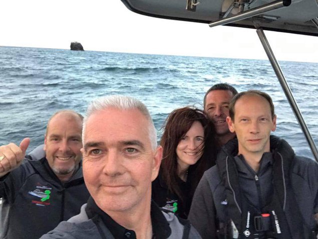 The ultimate selfie – Frank Kowalski (foreground) and the crew of Thunder Child at the small but very important ocean pinnacle of Rockall. Photo: Frank Kowalski
Home Well Before Dark for Thunderchild
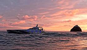
Apart from two essential stops at Portrush in County Antrim and Ballyglass on Broadhaven in County Mayo to take on fuel, Safehaven Marine’s challenge for a viable record for the 2000 kilometres round Ireland and Rockall, powering on with their remarkable new speed machine Thunderchild, has seen only two other stops writes W M Nixon.
One was to get a photo of the boat at Rockall itself last night, when enough daylight was available at the edge of the short northern darkness to produce a memorable and otherworldly image. And the other, specially important to a crew so closely involved with sea safety, was a pause at Black Rock off the Mayo coast this afternoon to pay their respects to the memory of the crew of air-sea rescue helicopter R 116, tragically lost on a March night four months ago in conditions very different from the summer weather which has now settled over Ireland.
But as this calm weather has followed on an unsettled period, the seas have taken time to smooth down. It’s seldom enough that Thunderchild has been able to enjoy a top speed of 52 knots in a voyage which at one stage saw her slowed back – albeit very briefly - to 20 knots. At 1845 hours this evening (Wednesday) she is at 42 knots coming in past the Fastnet, well on track to set a good time when she completes the circuit at the Old Head of Kinsale with an average speed of better than 33 knots, and neatly on time for a proper welcome home to Cobh well before dark.
It has to be the ulltimate selfie – Frank Kowalski of Safehaven and his crewmates on Thunderchild with Rockall looking very small for a place which could be of great maritime economic significance.
Shell Gives Up On Rockall, Says 'No Further Potential'

#Oil&Gas - The Irish Times reports that Shell and its partners have relinquished their State licence for hydrocarbon exploration at Rockall, claiming that it has "no further potential".
The decision – which means Shell no longer holds any offshore exploration licences in the State's waters – comes as a blow to a Government that recently announced the redoubling of its efforts to survey our coastal waters for new and exploitable oil and gas resources.
However, it is not unprecedented, as Shell admitted upon receipt of its licence for the Rockall Basin off Donegal in 2005 that the risk and expense of drilling at such a marginal deep-water site worked against any potential commercial gains.
The rapidly falling prices of oil and gas may also be playing a role in redirecting oil companies' attentions away from more peripheral prospects. The Irish Times has more on the story HERE.
Marine Scientists Make New Discoveries on the Rockall Bank

#marinescience – A team of thirteen marine scientists representing eight nationalities led by Dr Aggeliki Georgiopoulou from University College Dublin (School of Geological Sciences) and Dr Veerle Huvenne from the National Oceanography Centre, UK (Marine Geoscience), recently completed a two week (15th – 26 July) expedition on the RV Celtic Explorer, where they made new discoveries relating to the geology and biological habitats of the south-eastern slope of Rockall Bank.
In the North Atlantic, 270 nautical miles (520 km) away from the Irish coast, the team used the remotely operated vehicle ROV Holland I and the Marine Institute's new six metre gravity corer to gain an unprecedented look at landslide scarps of the Rockall Bank Slide Complex, as well as determine the connection between the biology, terrain characteristics and the geology of the area.
The creation of this series of deep-sea escarpments, related to the Rockall Bank Slide Complex, is believed to have taken place after the last ice age, around 15,000 years ago. "During the expedition we discovered that the scarps in this area are actually very different from one another both geologically and biologically, which we hadn't anticipated as they are in such close proximity to one another," says Dr Aggeliki Georgiopoulou.
With fifty rock samples and over twenty gravity cores retrieved, the team hope to be able to explain this diversity. "We now need to further review the samples and data to help answer questions such as: do these differences in the terrain mean that this wasn't one single landslide? Could these escarpments have formed in different episodes and that's why they look so different? This is the first time we took such a close look at a submarine landslide so it will take us some time to analyse the video and relate what we see to what we know – this is completely new information for us. The video footage has also revealed that seafloor pinnacles evident on the Irish National Seabed Survey map are in fact volcanic edifices, so far not documented or included in the geological maps of the Irish offshore," explained Dr Georgiopoulou.
The importance of this research lies in the fact that it helps scientists compare and understand the geologic behaviour of sediments and rock on slopes under the sea and hence establish a better understanding of the stability of our continental slope.
"The use of the new gravity corer provided scientists with an opportunity to retrieve three metre core sediments from areas under the seabed that haven't been reached before. Also capturing footage and taking samples using the Holland I gave us an unprecedented look at the terrain. It was as if we were in the field itself, walking around and selecting exactly the samples we needed, instead of taking a blind hit in 1000 m water depth. Now we know exactly where each of our rock samples, short cores and biological samples came from," said Dr Veerle Huvenne.
"The faulting or fracturing of the earth's surface under the sea is not as rare as people might think, but because it is not visible it is often not considered. The research of the scarps in this area will provide us with key information on the possibility of future land-slides in this region. As this particular slope is facing Ireland, if there were a new landslide to occur, we need to estimate if it would impact the Irish west coast," said Dr Georgiopoulou.
A second aim of the expedition was to collect material that will contribute to the mapping of Ireland's marine habitats, which is important for marine spatial planning, particularly in the context of the increasing use of deep-sea resources.
"Habitat mapping efforts so far have been unable to accurately represent areas of steep and near-vertical slopes, due to the limitations of the traditional techniques used. Traditionally, instruments only visualise and sample material straight down, directly below the ship, so vertical habitats are overlooked even though recent studies are showing they can be very rich," explained Dr Veerle Huvenne.
Using the ROV Holland I the team of scientists retrieved nearly 50 hours of seabed video footage and up to 60 biological samples for taxonomic identification and DNA analysis. "We also used a portable multi-beam echo-sounder, but deployed it in a totally novel configuration, that I have only tested twice before on the UK ROV Isis. Normally a multi-beam system looks downward under a research vessel and sweeps the seafloor in stripes that are collated to make a seafloor map. We however positioned the multi-beam on the front of the ROV Holland I, looking forward and sweeping the vertical cliffs, creating essentially maps of walls," Dr Huvenne further said.
Aodhán FitzGerald, the Marine Institute Research Vessel Program Coordinator thanked the ROV engineers and pilots and vessel crew and technicians for their successful configuration and deployment of the ROV, corer and other equipment, which enabled optimal sample and data acquisition.
Dr Peter Heffernan, CEO of the Marine Institute congratulated the team of scientists, highlighting the importance of using innovative new methodology and technology during the expedition saying, "this expedition is a further example of the importance of cooperation between universities, institutes and countries in researching our ocean and increasing our knowledge of its dynamic systems."
Activities during the expedition are documented on the Marine Institute blog: scientistsatsea.blogspot.ie
This research survey CE14011 SORBEH is supported by the Marine Institute, and is funded under the Marine Research Sub-Programme by the Irish Government with a contribution from the ERC CODEMAP project.
Portland Wave Piercer In 'Record' Rockall Round Trip
#Rockall - Motor Boat & Yachting reports on a potential new record round-trip offshore sailing from Portland in Dorset to Rockall in a remarkable 53-hour non-stop run on a single tank of fuel.
Maryslim, a 72ft wave piercer, set out from Portland Bill on a 'one boat, one team, one fuel tank' mission to complete the 1,422-mile voyage to and from the tiny disputed island in the North Atlantic off Ireland's northwest coast.
The crew were led by Richard Reddyhoff - who co-owns the boat with his wife Mary - who fronted a previous unsuccessful attempt to round the treacherous waters of Rockall in 2012.
But the weather window was just right this time round, and the team are now awaiting confirmation from the RYA of their hopefully record-smashing jaunt.
Motor Boat & Yachting has more on the story HERE.
New Species Confirmed At Rockall Deep Ocean Gas Vent
#MarineWildlife - Four new species of marine wildlife have been discovered off Rockall, as the Guardian reports.
It was a bonus Christmas present for marine scientists in Scotland who've announced that a handful of the array of deep ocean creatures found at the 'cold seep' methane gas vent in the North Atlantic - namely a large sea snail and two clams - have been confirmed as species new to science.
One of the clams, Thyasira scotiae, and the sea snail Volutopsius scotiae have been named after the research vessel MRV Scotia, while the clam Isorropodon mackayi is named in tribute to mollusc expert David Mackay. A marine worm also discovered is as yet unnamed pending examination.
As previously reported on Afloat.ie, the Rockall vent and its surrounds were discovered by scientists last year and since explored on a number of occasions - their findings prompting the International Convention on the Exploration of the Seas to recommend a ban on fishing in the area around the Rockall basin, 260 miles west of the Hebrides.
The new discoveries come in the same year as Irish researchers celebrate the discovery of an amazing new undersea world in the Whittard Canyon on the Irish Atlantic margin, containing larger than average molluscs that may be up to 200 years old.
Rockall Fishing Ban Recommended After New Marine Discoveries
#MarineWildlife - The Guardian reports that fishing is expected to be banned near Rockall after the recent discovery of a rare ocean floor gas vent and new species of shellfish.
The 'cold seep' methane vent found by Scotland-based marine scientists last year is only the third of its kind to be found in this region of the Atlantic Ocean - and apparently has a 'chemosynthetic' relationship with two species of deep-water clam, and the polychaete worms they contain, that are new to science.
Also found was a frilled shark, described as a 'living fossil' for existing as a species for at least 90 million years. Such sharks are seldom seen north of the tropics.
In the wake of these findings, the International Convention on the Exploration of the Seas has recommended a ban on fishing activity at the site and its surrounds.
Rockall - which adventurer Nick Hancock is attempting to occupy for a world record attempt - is a tiny rocky islet north-east of Donegal, almost halfway between Ireland and Iceland in the North Atlantic. It has long been the subject of territorial dispute, with Ireland, the UK, Iceland and Denmark all staking a claim.
The Guardian has much more on the story HERE.
Rockall Adventure Delayed By Heavy Seas

#Rockall - Endurance adventurer Nick Hancock has returned to port after having aborted his landing on the tiny island of Rockall in the North Atlantic.
As previously reported on Afloat.ie, the Briton was set to begin a two-month sojourn living on the minuscule rocky outcrop that experiences some of the world's largest waves inside an eight-foot water tank 'survival pod', in an effort to raise money for the Help for Heroes charity.
But The Guardian says heavy seas on Friday morning 31 May made landing on the island impossible, forcing his return to port at Harris in the Outer Hebrides.
"I'm disappointed, but not wholly surprised," he said upon his arrival. "We thought it was going to be all about the weather and swell, and we knew the weather window was really tight."
Hancock still hopes to get onto the island in the coming weeks and beat the previous solo stay record of 40 days set by SAS vet Tom McClean in 1985 and the 42-day record set by three Greenpeace protesters in 1997.
However, the rougher weather of late summer may scupper his plans to get off the island at the end of his stay if the adventure is delayed for much longer.
Ireland, the UK, Denmark and Iceland all lay claim to the disputed island northeast of the Donegal coast, which is 31m across at its widest point.
Rockall is New Home for British Record Breaker
A British man is set to spend two months inside an eight foot water tank on a desolate island in the North Atlantic as he tries to raise money for charity.
Nick Hancock is planning to set two endurance records by living on the 100ft island of Rockall and raise money for the Help for Heroes charity.
Rockall is constantly pounded by 3,000 miles of Atlantic swell. The world's largest recorded oceanic waves of over 95 feet were recorded there in 2000 - some 19 feet higher than Rockall itself.
Galway's Round Rockall Race Winner Applauded

#rockall – Galway city will get its first taste of what a week of seafaring parties and prize-giving ceremonies for intrepid sailors, some of whom have sailed around the world; others who have raced around the remote North Atlantic Island of Rockall, will be like.
The crews of the three boats, which took part in the inaugural Galway/Round Rockall Race, will be feted on the Main Stage in the Race Village complex in Galway Harbour at 7.30pm.
The race organised by Galway Bay Sailing Club, in advance of the Volvo Ocean Race finale, was won by Cork sailor Barry Hurley in his JOD 35 "Dinah". He sailed the 750 mile race single handed beating the German boat "Bank Von Bremen", which has a crew of nine, by two hours on corrected time.
The third boat in the race Jamie Young's "Killary Flyer" got back to Galway at 11.50 on Friday night. He also sailed the race single handed.
All three crews were given rousing receptions when they berthed in Galway Harbour. Tonight they will take centre stage at a ceremony to be attended by Minister of State for Tourism and Sport Michael Ring TD will officiate the prize giving.
Rockall Race Director Aodhán Fitzgerald said they expected the crews of the boats which had taken part in this fascinating race would be given a huge "Galway" welcome home tonight
Huge crowds are expected in Galway for the opening night of the nine festival which has been organised around the finale of the 39,000 mile Volvo Ocean Race. The six boats taking part in the race are expected to arrive in Galway from Lorient late on Monday night or early Tuesday morning.
The race organisers say they issue further updates over the week end on the likely arrival time of the fleet.


, at the sod-turning event for the new Deep Water Quay Development at the Rossaveal Fishery Harbour Centre. (Forbairt Ché Dhomhain, Lárionad Chuan Iascaigh Ros An Mhíl) in February")

