Menu

Ireland's sailing, boating & maritime magazine

Inland afloat headers


Displaying items by tag: wave

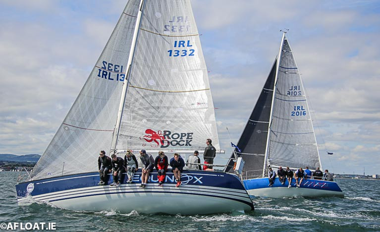
Following the cancellation of Cork Week 300, ICRA has decided to combine the National Championships with this year’s WAVE regatta which will take place at Howth Yacht Club from September 11-13th.

The decision was taken by unanimous vote by all the cruiser-racer representative Board Members at a strongly attended ICRA (remote) meeting this week, with the full support and backing of the RCYC Cork Week team.

The decision took into account a number of factors, including the desire to ensure that the event took place if at all possible and was not cancelled again, the costs and implications of running a standalone event at this stage and the understanding of ensuring boats and crews had some possible opportunity to get up to speed before the event.

The meeting chaired by Commodore Richard Colwell included Cxema Pico, RIYC; David Cullen, HYC; John Leech, LDYC; Ric Morris, RIYC; Johanna Murphy, GISC & SCORA; Peter Ryan, NYC; Denis Byrne, RCYC; Liam Lynch, TBSC. Brian Raftery of SBSC was absent.

The ICRA Committee also say they wish 'to thank generous offers from other clubs to host the regatta on alternate dates'.

Richard colwellICRA Commodore Richard Colwell

Commodore Richard Colwell commented “The ICRA Committee is saddened that the efforts of Cork Week cannot come to fruition so we have considered several alternative options for our annual ICRA National Championships. It was agreed that it would be prudent in the current environment, to delay the important National Championship regatta until as late as possible to try and ensure it goes ahead this year, so we have taken up the offer from Howth Yacht Club to combine the event with the WAVE regatta in September.”

"it would be prudent in the current environment, to delay the important National Championship regatta until as late as possible"

WAVE Chairman, Brian Turvey added “Our team in Howth is delighted to be able to lend support to ICRA for their 2020 Championships. Wave Regatta provides a relatively simple integration for the ICRA Nationals with much of the fleet already intending to compete and at a time of the year which suits many classes for their annual championships, not least that we are hopeful that the pandemic will have abated by then.”

Due to the uncertainty of which events will proceed, it has also been decided to cancel the original Boat of the Year schedule of races and keep under review.

Once we get clarity on what events will be proceeding, we will reissue a revised Notice of Race, ICRA spokesman Dave Cullen said.
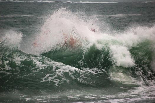
Published in ICRA
Tagged under

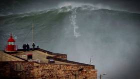
#RecordWave - Nineteen metres is the height of what’s being called the world’s largest wave, recorded recently off the North West Coast of Ireland.

Independent.ie reports on the record-breaking swell detected by a weather buoy in the North Atlantic between Ireland and Iceland, following what the World Meteorological Organization’s (WMO) Commission for Climatology described as a “very strong” cold front that passed through at more than 80km per hour.

WMO Assistant Secretary-General Wenjian Zhang said: ”This is the first time we have ever measured a wave of 19 metres. It is a remarkable record.”

The new measurement beats the previous record of 18.275 metres recorded in the North Atlantic nine years ago.

But while the news is causing gasps around the internet, for some it only confirms what’s long been known — that Ireland is on the doorstep of a big wave paradise.

Indeed, Ireland’s North West is no stranger to monster swells, with the giant surf offshore from Mullaghmore in Co Sligo a well-kept secret among the big wave surfing fraternity.

Published in Coastal Notes

The dangers of winter storms and the risk posed by freak waves are illustrated on the beach of Porsguen near to Portsall in Western France when a retired couple are swept away this month.

It is understood the couple survived the ordeal and rescued by coastal walkers.

The edge of the sea seems to be far enough away for the three people in this clip to be safe – but they are soon to learn that it isn’t.

A large wave crashed onto shore, knocking a pensioner to the floor. First his wife tries to save him before she too loses her footing and ends up being washed out.

The video was shot on the coast of France near Porsguen and uploaded onto YouTube by Olivier Lou who thanked locals Denise and Herve for giving them dry clothes.

Published in Water Safety
Tagged under

#castletownbere – The Department of Transport, Tourism and Sport has been advised that a wave measuring device has been installed on the seabed, adjacent to the Walter Scott Rock, at co-ordinates Latitude 51° 38' 33.6"N, Longitude 009° 54' 20.4"W. A yellow floating marker buoy with a special mark beacon has been installed to indicate the location of the device.

The wave study is being carried out by the Marine Engineering Division of the Department of Agriculture, Food & the Marine. The study is expected to be on-going until late March 2015, weather permitting.

For safety reasons, mariners are requested to keep a sharp lookout and to proceed slowly and with extreme caution in the vicinity of the Walter Scott Rock.

For safety reasons, fishermen are requested to avoid dredging at the co-ordinates mentioned above. Fisherman should take great care when dredging near this location and keep a wide berth from the device which is located on the seabed.

Published in Marine Warning
Tagged under

#wave – A new maximum wave height measuring nearly 80–feet (23 metres) has been recorded in weekend storms off the coast of Ireland.

Monster waves the height of five double deck buses occurred during last weekend's ferocious storms off the coast of Donegal, the worst for 30 years, according to Donegal news sources.

The M4 weather buoy, located off the Northwest coast, recorded a new maximum individual wave height of 23.4 metres at 15.00 on Sunday 26th January 2014 during the weekend storm that prompted an orange alert by the Coast Guard.

The new wave measurement easily surpasses the previous record of 20.4 metres at the same location in December 2011, according to Met Eireann.

The M4 buoy is one of a new generation of weather buoys with the ability to measure maximum wave height as well as the more usual Significant Wave Height.

The Significant Wave Height is defined as the average height of the highest one-third of the waves and that is what our forecasts of wave height refer to.

In general, the highest wave of all will be about twice the Significant Wave Height.

There was also a record for maximum significant wave height for the M4 buoy of 15.3m at the same time, with the previous record being 14.7m. The all-time record for Significant Wave Height still rests with the M6 buoy of 17.2m.

more from Met Eireann on this story here

Published in Weather
Tagged under

#SURFING - British surfer Jayce Robinson wasn't about to let the largest wave ever recorded off Ireland's shores go by without giving it a shot.

And as Sky News Online reports, he was captured doing exactly that on Tuesday afternoon.

The Cornish surfing pro told the website: "It was definitely the biggest barrell I've ever surfed.

"I was a little nervous but I didn't have time to think about it - it's almost like a car crash, you don't know what's happening."

Robinson rode the giant wave for 20 seconds before the lip crashed down and knocked him off his board.

His surfing partner Lyndon Wake, who towed him to the swell at Mullaghmore Head, said: "It's always a worst case scenario when your tow partner wipes out. Lucky he managed to come out the other side OK."

As previously reported on Afloat.ie, storm force winds off the coast of Donegal produced monster rollers of over 20 metres (over 60 feet) in height detected in Donegal Bay.

Mullaghmore Head will once again welcome the world's top big wave surfers for the second annual Tow-In Surf Session in the New Year.

Published in Surfing

#WAVE – The biggest ever wave in Irish waters was recorded yesterday when storm force winds off the Coast of Donegal produced monster rollers of over 20 metres (over 60 feet) in height off the Northwest tip of Ireland. At least two giant waves put meterologists on alert yesterday prompting the Coastguard to issue a weather warning.

The 20.4 metre wave was detected in Donegal Bay by the M4 weather buoy, according to Met Eireann. The wave was recorded at 2pm yesterday.  (Tuesday 13th December 2011),

Meteorologists said sea conditions, about 60 miles out to sea, were the most serious they had ever experienced. The Irish Coastguard said they had recorded winds of up to 140km per hour off the north-western coast yesterday and issued a warning.

The M4 weather buoy is located 75km north of Belmullet on the north west coast of Ireland. The M4 buoy forms part of the Irish Weather Buoy Network which began in 2000 and is funded by the Department of Transport, Tourism and Sport and run by the Marine Institute in collaboration with Met Eireann and the UKMO.

"This is the largest wave measured on the Weather buoy network to date. However, these recordings are a result of the next generation buoy which was deployed last year. Historically, only the significant wave height could be measured by the older buoys, where heights of between 10 and 13 meters were typically recorded around the coast during winter. The next generation buoys allow us to record and transmit both significant wave height and maximum wave heights as part of our hourly observations," explains Sheena Fennell, oceanographer with the Marine Institute.

Over the last number of years the network has been going through a transitional phase replacing the older models with next generation buoys supplied by Fugro Oceanor. The combination of high quality real time measurements coming from the offshore buoys and coastal systems, coupled with the mathematical forecasting models, is extending the well proven ability of scientists and engineers to accurately forecast the atmospheric conditions and sea state of the ocean.

"With the development in technology we are now able to record maximum wave heights which the older style buoys couldn't do. This parameter will form an important part of forecasting as we move forward." Sheena Fennell further said.

Met Eireann say the stormy conditions will gradually ease off tonight, but then frost and icy patches will develop. However it will remain very windy for a time early tonight, with severe southwest to west gales.

Published in Coastal Notes
Tagged under

Ireland has battened down the hatches because of fears Hurricane Katia would wreak widespread havoc with storm-force winds and giant waves. The Coast Guard has issued a weather alert warning people to stay away from cliff edges. Boaters are also warned of the dangers of walking near exposed quays.

hurricane_katia

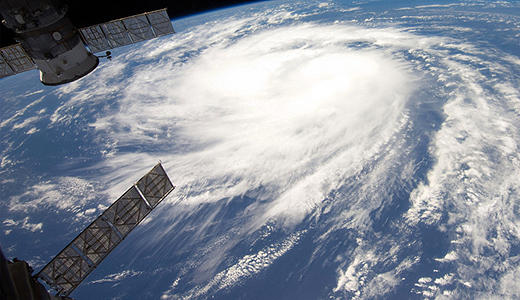
Hurricane Katia as seen from the space station

Published in Marine Warning
Spectacular photographs taken from the shore by Lifeboat Operations Manager John Brittain during Clifden RNLI's special surf training recently on Dunloughan beach show the type of conditions that volunteer lifeboat crew train in for the life-saving charity. The shots capture the inshore lifeboat crewmembers climbing a wave and exercising in some choppy conditions.

John organised the training in response to the increased popularity of the area with surfers.  RNLI Divisional Assessor Trainer Helena Duggan travelled to the lifeboat station to put 18 volunteer lifeboat crew through their paces and train them in handling the lifeboat in surf and responding to potential callouts from leisure marine enthusiasts.

Training is a core part of volunteering with the RNLI and each crewmember in Clifden trains once a fortnight on the stations two inshore lifeboats.

Commenting on the exercise John said, "I took my camera down to photograph the exercise and was really pleased with the results.  It is great to be able to show the public what our lifeboat volunteers go through to ensure they are fit and trained to go to sea. We had a fantastic turnout on the day and the lifeboat crew learned about boat handling in surf conditions. We are delighted so many people are visiting the area for leisure marine activities."

clifden_d_class_1

clifden_d_class_2

clifden_d_class_3

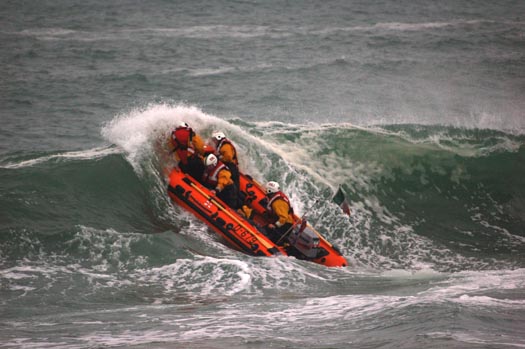
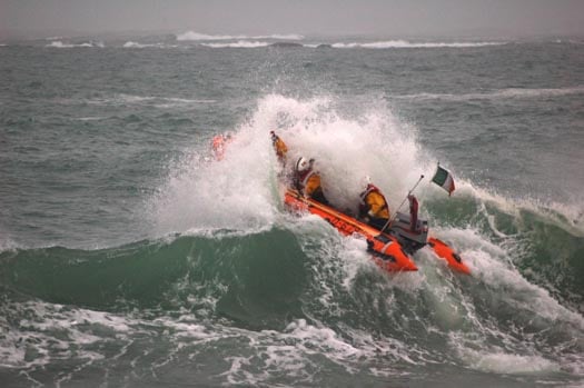
Photos by John Brittain/Clifden RNLI show Clifden volunteer lifeboat crew with RNLI Training assessor Helena Duggan during surf training on Dunloughan beach, Ballyconeely

Related Safety posts

RNLI Lifeboats in Ireland


Safety News


Rescue News from RNLI Lifeboats in Ireland


Coast Guard News from Ireland


Water Safety News from Ireland

Marine Casualty Investigation Board News

Marine Warnings

Published in RNLI Lifeboats

A US renewable energy company is proposing to meet the Government’s target of generating 500 megawatts of electricity from ocean energy systems by 2020, holding out the possibility of generating tens of thousands of jobs in Ireland. Frank McDonald's story in the Irish Times this morning is here.


Published in Marine Science

General Information on using Waterways Ireland inland navigations

Safety on the Water

All users of the navigations are strongly recommended to make themselves aware of safety on the water for whatever activity they are involved in and to read the advice offered by the various governing bodies and by:

The Dept. of Transport, Ireland: www.gov.ie/transport and The Maritime and Coastguard Agency, UK, The RNLI – Water Safety Ireland for information in terms of drowning prevention and water safety.

Registration of Vessels

All vessels using the Shannon Navigation, which includes the Shannon-Erne Waterways and the Erne System must be registered with Waterways Ireland. Only open undecked boats with an engine of 15 horsepower or less on the Shannon Navigation, and vessels of 10 horsepower or less on the Erne System, are exempt. Registration is free of charge.

Craft registration should be completed online at: https://www.waterwaysireland.org/online-services/craft-registration

Permits for use of the Grand and Royal Canals and the Barrow Navigation

All vessels using the Grand and Royal Canals and the Barrow Navigation must display appropriate valid Permit(s) i.e A Combined Mooring and Passage Permit (€126) and if not intending to move every five days, an Extended Mooring Permit (€152).

Permit applications should be completed online at: https://www.waterwaysireland.org/online-services/canal-permits

Passage on the Royal and Grand Canals – Dublin Area

For boat passage through the locks east of Lock 12 into / out of Dublin on either the Royal or Grand Canals, Masters are requested to contact the Waterways Ireland Eastern Regional Office (M-F 9.30am-4.30pm) on tel: +353(0)1 868 0148 or email [email protected] prior to making passage in order to plan the necessary lock-keeping assistance arrangements.

On the Grand Canal a minimum of two days notice prior to the planned passage should be given, masters should note that with the exception of pre-arranged events, a maximum of 2 boats per day will be taken through the locks, travelling either east or west.

Movements in or out of the city will be organised by prior arrangement to take place as a single movement in one day. Boaters will be facilitated to travel the system if their passage is considered to be safe by Waterways Ireland and they have the valid permit(s) for mooring and passage.

Newcomen Lifting Bridge

On the Royal Canal two weeks’ notice of bridge passage (Newcomen Lifting Bridge) is required for the pre-set lift date, and lock assistance will then also be arranged. A minimum of 2 boats is required for a bridge lift to go ahead.

Waterways Ireland Eastern Regional Office (Tel: +353(0)1 868 0148 or [email protected] ) is the point of contact for the bridge lift.

A maximum number of boats passing will be implemented to keep to the times given above for the planned lifts (16 for the Sat / Sun lifts & 8 for the weekday lifts). Priority will be given on a first come first served basis.

On day of lift, boaters and passengers must follow guidance from Waterways Ireland staff about sequence of passage under bridge & through Lock 1, and must remain within signed and designated areas.

Events Held on the Waterways

All organised events taking place on the waterways must have the prior approval of Waterways Ireland. This is a twelve week process and application forms must be accompanied with the appropriate insurance, signed indemnity and risk assessment. The application should be completed on the Waterways Ireland events page at :

https://www.waterwaysireland.org/online-services/event-approval

Time Limits on Mooring in Public Harbours

On the Shannon Navigation and the Shannon-Erne Waterway craft may berth in public harbours for five consecutive days or a total of seven days in any one month.

On the Erne System, revised Bye Laws state that: No master or owner shall permit a vessel, boat or any floating or sunken object to remain moored at or in the vicinity of any public mooring, including mooring at any other public mooring within 3 kilometres of that location, for more than 3 consecutive days and shall not moor at that same mooring or any other public mooring within 3 kilometres of that location within the following 3 consecutive days without prior permission by an authorised official.

Winter Mooring on the Shannon Navigation and Shannon Erne Waterway

Winter mooring may be availed of by owners during the period 1 Nov to 31 Mar by prior arrangement and payment of a charge of €63.50 per craft. Craft not availing of Winter Mooring must continue to comply with the “5 Day Rule”. Winter Mooring applications should be completed online at : https://www.waterwaysireland.org/online-services/winter-moorings-booking

Owners should be aware that electricity supply and water supply to public moorings is disconnected for the winter months. This is to protect against frost damage, to reduce running costs and to minimise maintenance requirements during the winter months.

Vessel owners are advised that advance purchasing of electricity on the power bollards leading up to the disconnection date should be minimal. Electricity credit existing on the bollards will not be recoverable after the winter decommissioning date. Both services will be reinstated prior to the commencement of the next boating season.

Smart Cards

Waterways Ireland smart cards are used to operate locks on the Shannon Erne Waterway, to access the service blocks, to use the pump-outs along the navigations, to avail of electrical power at Waterways Ireland jetties.

Berthing in Public Harbours

Masters are reminded of the following:

  • Equip their vessel with mooring lines of appropriate length and strength and only secure their craft to mooring bollards and cleats provided for this purpose.
  • Ensure the available berth is suitable to the length of your vessel, do not overhang the mooring especially on finger moorings on floating pontoon moorings.
  • Ensure mooring lines, electric cables and fresh water hoses do not create a trip hazard on public jetties for others users.
  • Carry sufficient fenders to prevent damage to your own vessel, other vessels and WI property.
  • Allow sufficient space between your vessel and the vessel ahead /astern (c.1m) for fire safety purposes and /or to recover somebody from the water.
  • Do not berth more than two vessels side by side and ensure there is safe access/egress at all times between vessels and onto the harbour itself.
  • Do not berth in such a way to prevent use of harbour safety ladders, slipways or pump-outs.
  • Do not allow the bow of your vessel to overhang the walkway of a floating mooring thus creating a hazard for others with an overhanging anchor or bow fendering.
  • Animals are not allowed to be loose or stray at any time.
  • Harbour and jetty infrastructure such as railings, power pedestals, fresh water taps, electric light poles, safety bollards, ladders etc are not designed for the purpose of mooring craft , they will not bear the strain of a vessel and will be damaged.
  • At Carrybridge on the Erne System, Masters of vessels are not permitted to use stern on mooring. Masters of vessels must use the mooring fingers for mooring of vessels and for embarkation / disembarkation from vessels.

Passenger Vessel Berths

Masters of vessels should not berth on passenger vessel berths where it is indicated that an arrival is imminent. Passenger vessels plying the navigations generally only occupy the berths to embark and disembark passengers and rarely remain on the berths for extended periods or overnight.

Lock Lead-in Jetties

Lead-in jetties adjacent to the upstream and downstream gates at lock chambers are solely for the purpose of craft waiting to use the lock and should not be used for long term berthing.

Vessel Wake

Vessel wake, that is, the wave generated by the passage of the boat through the water, can sometimes be large, powerful and destructive depending on the hull shape and engine power of the vessel. This wake can be detrimental to other users of the navigation when it strikes their craft or inundates the shoreline or riverbank. Masters are requested to frequently look behind and check the effect of their wake / wash particularly when passing moored vessels, on entering harbours and approaching jetties and to be aware of people pursuing other activities such as fishing on the riverbank.

Speed Restriction

A vessel or boat shall not be navigated on the Shannon Navigation at a speed in excess of 5 kph when within 200 metres of a bridge, quay, jetty or wharf, when in a harbour or canal or when passing within 100 metres of a moored vessel or boat.

Vessels navigating the Shannon-Erne Waterway should observe the general 5 kph speed limit which applies along the waterway. This is necessary in order to prevent damage to the banks caused by excessive wash from vessels.

Vessels navigating the Erne System should observe the statutory 5kt / 6mph / 10kph speed limit areas.

A craft on the Royal and Grand canals shall not be navigated at a speed in excess of 6km per hour.

A craft on the Barrow Navigation shall not be navigated at a speed in excess of 11km per hour except as necessary for safe navigation in conditions of fast flow.

Bank Erosion

Narrow sections of all the navigations are particularly prone to bank erosion due to the large wash generated by some craft. Masters are requested to be vigilant and to slow down to a speed sufficient to maintain steerage when they observe the wash of their craft inundating the river banks.

Unusual Waterborne Activity

Unusual waterborne vessels may be encountered from time to time, such as, hovercraft or amphibious aircraft / seaplanes. Masters of such craft are reminded to apply the normal “Rule of the Road” when they meet conventional craft on the water and to allow extra room to manoeuvre in the interest of safety.

Sailing Activity

Mariners will encounter large numbers of sailing dinghies from late June to August in the vicinity of Lough Derg, Lough Ree and Lower Lough Erne. Sailing courses are marked by yellow buoys to suit weather conditions on the day. Vessels should proceed at slow speed and with due caution and observe the rules of navigation when passing these fleets, as many of the participants are junior sailors under training.

Rowing

Mariners should expect to meet canoes and vessels under oars on any part of the navigations, but more so in the vicinity of Athlone, Carrick-on-Shannon, Coleraine, Enniskillen and Limerick. Masters are reminded to proceed at slow speed and especially to reduce their wash to a minimum when passing these craft as they can be easily upset and swamped due to their very low freeboard and always be prepared to give way in any given traffic situation.

Canoeing

Canoeing is an adventure sport and participants are strongly recommended to seek the advice of the sport’s governing bodies i.e Canoeing Ireland and the Canoe Association of Northern Ireland, before venturing onto the navigations.

Persons in charge of canoes are reminded of the inherent danger to these craft associated with operating close to weirs, sluice gates, locks and other infrastructure particularly when rivers are in flood and large volumes of water are moving through the navigations due to general flood conditions or very heavy localised precipitation e.g. turbulent and broken water, stopper waves. Shooting weirs is prohibited without prior permission of Waterways Ireland.

Canoeists should check with lockkeepers prior entering a lock to ensure passage is done in a safe manner. Portage is required at all unmanned locks.

Canoe Trail Network – "Blueways"

Masters of powered craft are reminded that a canoe trail network is being developed across all navigations and to expect more organised canoeing along these trails necessitating slow speed and minimum wash when encountering canoeists, rowing boats etc

Rockingham and Drummans Island Canals – Lough Key

It is expected that work on Rockingham and Drummans Island Canals on Lough Key will be completed in 2021. Access to these canals will be for non-powered craft only, eg canoes, kayaks, rowing boats.

Fast Powerboats and Personal Watercraft (Jet Skis)

Masters of Fast Powerboats (speed greater than 17kts) and Personal Watercraft (i.e.Jet Skis) are reminded of the inherent dangers associated with high speed on the water and especially in the confines of small bays and narrow sections of the navigations. Keeping a proper look-out, making early alterations to course and /or reducing speed will avoid conflict with slower vessels using the navigation. Personal Watercraft are not permitted to be used on the canals.

Towing Waterskiers, Wakeboarders, Doughnuts etc

Masters of vessels engaged in any of these activities are reminded of the manoeuvring constraints imposed upon their vessel by the tow and of the added responsibilities that they have to the person(s) being towed. These activities should be conducted in areas which are clear of conflicting traffic. It is highly recommended that a person additional to the master be carried to act as a “look-out” to keep the tow under observation at all times.

Prohibition on Swimming

Swimming in the navigable channel, particularly at bridges, is dangerous and is prohibited due to the risk of being run over by a vessel underway in the navigation.

Age Restrictions on operating of powered craft

In the Republic of Ireland, Statutory Instrument 921 of 2005 provides the legal requirements regarding the minimum age for operating of powered craft. The Statutory Instrument contains the following requirements:

- The master or owner of a personal watercraft or a fast power craft shall take all reasonable steps to ensure that a person who has not attained the age of 16 years does not operate or control the craft

- The master or owner of a pleasure craft powered by an engine with a rating of more than 5 horse power or 3.7 kilowatts shall take all reasonable steps to ensure that a person who has not attained the age of 12 years does not operate or control the craft.

Lifejackets and Personal Flotation Devices (PFDs)

Lifejackets and PFD’s are the single most important items of personal protective equipment to be used on a vessel and should be worn especially when the vessel is being manoeuvred such as entering / departing a lock, anchoring, coming alongside or departing a jetty or quayside.

In the Republic of Ireland, Statutory Instrument 921 of 2005 provides the legal requirements regarding the wearing of Personal Flotation Devices. The Statutory Instrument contains the following requirements:

- The master or owner of a pleasure craft (other than a personal watercraft) shall ensure, that there are, at all times on board the craft, sufficient suitable personal flotation devices for each person on board.

- A person on a pleasure craft (other than a personal watercraft) of less than 7 metres length overall shall wear a suitable personal flotation device while on board an open craft or while on the deck of decked craft, other than when the craft is made fast to the shore or at anchor.

- The master or owner of a pleasure craft (other than a personal watercraft) shall take all reasonable steps to ensure that a person who has not attained the age of 16 years complies with paragraph above.

- The master or owner of a pleasure craft (other than a personal watercraft), shall take all reasonable steps to ensure that a person who has not attained the age of 16 years wears a suitable personal flotation device while on board an open craft or while on the deck of a decked craft other than when it is made fast to the shore or at anchor.

- The master or owner of a pleasure craft (other than a personal watercraft) shall take all reasonable steps to ensure that a person wears a suitable personal flotation device, at all times while – (a) being towed by the craft, (b) on board a vessel or object of any kind which is being towed by the craft.

Further information is available at: http://www.irishstatutebook.ie/eli/2005/si/921/made/en/print

Firing Range Danger Area – Lough Ree

The attention of mariners is drawn to the Irish Defence Forces Firing Range situated in the vicinity of buoys No’s 2 and 3, on Lough Ree on the Shannon Navigation. This range is used regularly for live firing exercises, throughout the year, all boats and vessels should stay clear of the area marked with yellow buoys showing a yellow "X" topmark and displaying the word "Danger".

Shannon Navigation, Portumna Swing Bridge Tolls

No attempt should be made by Masters’ of vessels to pay the bridge toll while making way through the bridge opening. Payment will only be taken by the Collector from Masters when they are secured alongside the jetties north and south of the bridge.

Navigating from Killaloe to Limerick on the Shannon Navigation

The navigation from Killaloe to Limerick involves passage through Ardnacrusha locks, the associated headrace and tailrace and the Abbey River into Limerick City. Careful passage planning is required to undertake this voyage. Considerations include: lock passage at Ardnacrusha, water flow in the navigation, airdraft under bridges on Abbey River in Limerick, state of tide in Limerick

Users are advised to contact the ESB Ardnacrusha hydroelectric power station (00353 (0)87 9970131) 48 hours in advance of commencing their journey to book passage through the locks at Ardnacrusha. It is NOT advised to undertake a voyage if more than one turbine is operating (20MW), due to the increased velocity of flow in the navigation channel, which can be dangerous. To ascertain automatically in real time how many turbines are running, users can phone +353 (0)87 6477229.

For safety reasons the ESB has advised that only powered craft with a capacity in excess of 5 knots are allowed to enter Ardnacrusha Headrace and Tailrace Canals.

Passage through Sarsfield Lock should be booked on +353-87-7972998, on the day prior to travel and it should be noted also that transit is not possible two hours either side of low water.

A Hydrographic survey in 2020 of the navigation channel revealed that the approach from Shannon Bridge to Sarsfield Lock and the Dock area has silted up. Masters of vessels and water users are advised to navigate to the Lock from Shannon bridge on a rising tide one or two hours before High Tide.

Lower Bann Navigation

The attention of all users is drawn to the “Users Code for the Lower Bann”, in particular to that section covering “Flow in the River” outlining the dangers for users both on the banks and in the navigation, associated with high flow rates when the river is in spate. Canoeists should consult and carry a copy of the “Lower Bann Canoe Trail” guide issued by the Canoe Association of Northern Ireland. Users should also contact the DfI Rivers Coleraine, who is responsible for regulating the flow rates on the river, for advisory information on the flow rates to be expected on any given day.

DfI Rivers Coleraine. Tel: 0044 28 7034 2357 Email: [email protected]

Lower Bann Navigation – Newferry – No wake zone

A No Wake Zone exists on the Lower Bann Navigation at Newferry. Masters of vessels are requested to proceed at a slow speed and create no wake while passing the jetties and slipways at Newferry.

Overhead Power Lines (OHPL) and Air draft

All Masters must be aware of the dangers associated with overhead power lines, in particular sailing vessels and workboats with cranes or large air drafts. Voyage planning is a necessity in order to identify the location of overhead lines crossing the navigation.

Overhead power line heights on the River Shannon are maintained at 12.6metres (40 feet) from Normal Summer level for that section of navigation, masters of vessels with a large air draft should proceed with caution and make additional allowances when water levels are high.

If a vessel or its equipment comes into contact with an OHPL the operator should NOT attempt to move the vessel or equipment. The conductor may still be alive or re-energise automatically. Maintain a safe distance and prevent third parties from approaching due to risk of arcing. Contact the emergency services for assistance.

Anglers are also reminded that a minimum ground distance of 30 metres should be maintained from overhead power lines when using a rod and line.

Submarine Cables and Pipes

Masters of vessels are reminded not to anchor their vessels in the vicinity of submarine cables or pipes in case they foul their anchor or damage the cables or pipes. Look to the river banks for signage indicating their presence.

Water Levels - Precautions

Low Water Levels:

When water levels fall below normal summer levels masters should be aware of:

Navigation

To reduce the risk of grounding masters should navigate on or near the centreline of the channel, avoid short cutting in dog-legged channels and navigating too close to navigation markers.

Proceeding at a slow speed will also reduce “squat” effect i.e. where the vessel tends to sit lower in the water as a consequence of higher speed.

Slipways

Reduced slipway length available under the water surface and the possibility of launching trailers dropping off the end of the concrete apron.

More slipway surface susceptible to weed growth requiring care while engaged in launching boats, from slipping and sliding on the slope. Note also that launching vehicles may not be able to get sufficient traction on the slipway once the craft is launched to get up the incline.

Bank Erosion

Very dry riverbanks are more susceptible to erosion from vessel wash.

Lock Share

Maximising on the number of vessels in a lock will ensure that the total volume of water moving downstream is decreased. Lock cycles should be used for vessels travelling each way.

High Water Levels:

When water levels rise above normal summer level masters should be aware of:

Navigation

Navigation marks will have reduced height above the water level or may disappear underwater altogether making the navigable channel difficult to discern.

In narrow sections of the navigations water levels will tend to rise more quickly than in main streams and air draft at bridges will likewise be reduced.

There will also be increased flow rates particularly in the vicinity of navigation infrastructure such as bridges, weirs, locks etc where extra care in manoeuvring vessels will be required.

Harbours and Jetties

Due care is required in harbours and at slipways when levels are at or near the same level as the harbour walkways' as the edge will be difficult to discern especially in reduced light conditions. It is advised that Personal Flotation Devices be worn if tending to craft in a harbour in these conditions.

Slipways

Slipways should only be used for the purpose of launching and recovering of water craft or other objects from the water. Before using a slipway it should be examined to ensure that the surface has sufficient traction/grip for the intended purpose such as launching a craft from a trailer using a vehicle, that there is sufficient depth of water on the slipway to float the craft off the trailer before the concrete apron ends and that the wheels of the trailer do not drop off the edge of the slipway. That life-saving appliances are available in the vicinity, that the vehicle is roadworthy and capable of coping with the weight of the trailer and boat on the incline. It is recommended that slipway operations are conducted by two persons.

Caution to be Used in Reliance upon Aids to Navigation

The aids to navigation depicted on the navigation guides comprise a system of fixed and floating aids to navigation. Prudent mariners will not rely solely on any single aid to navigation, particularly a floating aid to navigation. With respect to buoys, the buoy symbol is used to indicate the approximate position of the buoy body and the ground tackle which secures it to the lake or river bed. The approximate position is used because of the practical limitations in positioning and maintaining buoys in precise geographical locations. These limitations include, but are not limited to, prevailing atmospheric and lake/river conditions, the slope of and the material making up the lake/river bed, the fact that the buoys are moored to varying lengths of chain, and the fact that the buoy body and/or ground tackle positions are not under continuous surveillance. Due to the forces of nature, the position of the buoy body can be expected to shift inside and outside the charted symbol.

Buoys and perches are also moved out of position or pulled over by those mariners who use them to moor up to instead of anchoring. To this end, mariners should always monitor their passage by relating buoy/perch positions with the published navigation guide. Furthermore, a vessel attempting to pass close by always risks collision with a yawing buoy or with the obstruction that the buoy or beacon/perch marks.

Masters of Vessels are requested to use the most up to date Navigation guides when navigating on the Inland Waterways.

Information taken from Special Marine Notice No 1 of 2023