Menu

Ireland's sailing, boating & maritime magazine

Dublin Bay Boating News and Information

Displaying items by tag: Irish Sea Border

The Minister for Foreign Affairs Simon Coveney has told Britain's Foreign Secretary that proposed legislation to change to Northern Ireland Protocol will create a whole new set of uncertainties and damage relationships.

The British government is due to publish details of proposed legislation to give ministers the power to override parts of the protocol.

The Irish Government and European Union have warned against unilateral action and urged a return to the negotiating table, but those pleas are set to be ignored.

Mr Coveney said it marks a particular low point in the UK’s approach to Brexit.

He spoke to Ms Truss by phone this morning, where she outlined her intention to publish the legislation today.

Mr Coveney said publishing legislation that would breach the UK's commitments under international law, the Brexit Withdrawal Agreement and Northern Ireland Protocol is deeply damaging to relationships on these islands and between the UK and EU.

For more RTE News reports.

Published in Ports & Shipping

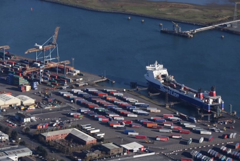
Politicians from the Unionist tradition, The Irish Times writes, have responded with annoyance and dismay after a junior Sinn Féin Minister told a Stormont committee that there will be new physical border posts at Northern Ireland ports.

An “Irish Sea border is now a certainty”, the Ulster Unionist Party leader Steve Aiken said on Thursday following comments by Sinn Féin Minister Declan Kearney that border posts are to be created to deal with trade coming into Northern Ireland from Britain.

Mr Kearney told the Assembly’s Executive Office scrutiny committee that the “British government has confirmed it will urgently put in place detailed plans with the Executive, which does include the physical posts at ports of entry”.

(The Minister) Mr Kearney informed former Sinn Féin MEP Martina Anderson that the British government had signalled that “delivery on that infrastructure needs to start as soon as possible”.

“The British government has indicated that it will provide advice on the requirements and the funding to put that in place.”

Ms Anderson, in her questioning of Mr Kearney on Wednesday, indicated the posts would be at Belfast, Larne and Warrenpoint and would be designed to accommodate additional customs officers and vets, who would be dealing with livestock.

More on this Brexit development here. 

Published in Ferry

In a major change from the original Northern Ireland backstop to avoid a hard border will require a huge leap into the unknown. It is the area of customs.

In practical terms, The Irish Times reports, this is the most complex part of the proposed Brexit plan to manage, with much of the small print yet to be written.

By dropping the idea of a EU-UK customs territory in the original plan, London and Brussels have agreed to allow Northern Ireland to leave the EU customs union while still applying the bloc’s customs rules there.

In an effort to maintain an open Irish Border, the EU is outsourcing checks on goods coming on to the island – and possibly into the EU market – to the UK authorities, with EU officials entitled to be present for checks at (ferry)ports in the North, Scotland and England.

Beyond a broad line of how it would work, there is little detail on how it will be managed. It is not clear what exactly would happen to a truckload of widgets travelling from Scotland to Northern Ireland through Belfast Port on to Dublin and then further into the EU market. A similar customs proposal from the UK was dismissed last year by Brussels as unworkable.

The newspaper has more here to read. 

Afloat adds today marks the fourth and final day of the British Ports Association's annual conference which for the first time was hosted by Belfast Harbour. More than 300 industry representatives from across the UK and Ireland are attending.

As previously reported on Afloat, in advance of the event the BPA discussed the UK Government's 'new Brexit Border plan'. 

Published in Belfast Lough

Dublin Bay

Dublin Bay on the east coast of Ireland stretches over seven kilometres, from Howth Head on its northern tip to Dalkey Island in the south. It's a place most Dubliners simply take for granted, and one of the capital's least visited places. But there's more going on out there than you'd imagine.

The biggest boating centre is at Dun Laoghaire Harbour on the Bay's south shore that is home to over 1,500 pleasure craft, four waterfront yacht clubs and Ireland's largest marina.

The bay is rather shallow with many sandbanks and rocky outcrops, and was notorious in the past for shipwrecks, especially when the wind was from the east. Until modern times, many ships and their passengers were lost along the treacherous coastline from Howth to Dun Laoghaire, less than a kilometre from shore.

The Bay is a C-shaped inlet of the Irish Sea and is about 10 kilometres wide along its north-south base, and 7 km in length to its apex at the centre of the city of Dublin; stretching from Howth Head in the north to Dalkey Point in the south. North Bull Island is situated in the northwest part of the bay, where one of two major inshore sandbanks lie, and features a 5 km long sandy beach, Dollymount Strand, fronting an internationally recognised wildfowl reserve. Many of the rivers of Dublin reach the Irish Sea at Dublin Bay: the River Liffey, with the River Dodder flow received less than 1 km inland, River Tolka, and various smaller rivers and streams.

Dublin Bay FAQs

There are approximately ten beaches and bathing spots around Dublin Bay: Dollymount Strand; Forty Foot Bathing Place; Half Moon bathing spot; Merrion Strand; Bull Wall; Sandycove Beach; Sandymount Strand; Seapoint; Shelley Banks; Sutton, Burrow Beach

There are slipways on the north side of Dublin Bay at Clontarf, Sutton and on the southside at Dun Laoghaire Harbour, and in Dalkey at Coliemore and Bulloch Harbours.

Dublin Bay is administered by a number of Government Departments, three local authorities and several statutory agencies. Dublin Port Company is in charge of navigation on the Bay.

Dublin Bay is approximately 70 sq kilometres or 7,000 hectares. The Bay is about 10 kilometres wide along its north-south base, and seven km in length east-west to its peak at the centre of the city of Dublin; stretching from Howth Head in the north to Dalkey Point in the south.

Dun Laoghaire Harbour on the southside of the Bay has an East and West Pier, each one kilometre long; this is one of the largest human-made harbours in the world. There also piers or walls at the entrance to the River Liffey at Dublin city known as the Great North and South Walls. Other harbours on the Bay include Bulloch Harbour and Coliemore Harbours both at Dalkey.

There are two marinas on Dublin Bay. Ireland's largest marina with over 800 berths is on the southern shore at Dun Laoghaire Harbour. The other is at Poolbeg Yacht and Boat Club on the River Liffey close to Dublin City.

Car and passenger Ferries operate from Dublin Port to the UK, Isle of Man and France. A passenger ferry operates from Dun Laoghaire Harbour to Howth as well as providing tourist voyages around the bay.

Dublin Bay has two Islands. Bull Island at Clontarf and Dalkey Island on the southern shore of the Bay.

The River Liffey flows through Dublin city and into the Bay. Its tributaries include the River Dodder, the River Poddle and the River Camac.

Dollymount, Burrow and Seapoint beaches

Approximately 1,500 boats from small dinghies to motorboats to ocean-going yachts. The vast majority, over 1,000, are moored at Dun Laoghaire Harbour which is Ireland's boating capital.

In 1981, UNESCO recognised the importance of Dublin Bay by designating North Bull Island as a Biosphere because of its rare and internationally important habitats and species of wildlife. To support sustainable development, UNESCO’s concept of a Biosphere has evolved to include not just areas of ecological value but also the areas around them and the communities that live and work within these areas. There have since been additional international and national designations, covering much of Dublin Bay, to ensure the protection of its water quality and biodiversity. To fulfil these broader management aims for the ecosystem, the Biosphere was expanded in 2015. The Biosphere now covers Dublin Bay, reflecting its significant environmental, economic, cultural and tourism importance, and extends to over 300km² to include the bay, the shore and nearby residential areas.

On the Southside at Dun Laoghaire, there is the National Yacht Club, Royal St. George Yacht Club, Royal Irish Yacht Club and Dun Laoghaire Motor Yacht Club as well as Dublin Bay Sailing Club. In the city centre, there is Poolbeg Yacht and Boat Club. On the Northside of Dublin, there is Clontarf Yacht and Boat Club and Sutton Dinghy Club. While not on Dublin Bay, Howth Yacht Club is the major north Dublin Sailing centre.

© Afloat 2020