Menu

Ireland's sailing, boating & maritime magazine

Displaying items by tag: S2S

Dun Laoghaire-Rathdown Councillor Barry Ward will be among the speakers at a public meeting in Dun Laoghaire later this month on the S2S (Sutton to Sandycove) coastal promenade and cycleway around Dublin Bay.

Long in the development stages, the S2S has been beset by planning snags and funding issues, and as yet only sections on the northern side of Dublin Bay between Sutton and Clontarf have been completed.

Michael Collins (S2S) and Clara Clark (Cycling Without Age) will also address the meeting at the Royal Marine Hotel on Tuesday 22 October from 7.30pm to discuss current and future moves on the project, including the €17.5 million allocated earlier this year for the section from Merrion Gates to Dun Laoghaire Harbour.

All are welcome to attend.

Tagged under

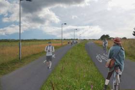
#Coastal - Planning permission has been granted for a new coastal cycle and walking path between Baldoyle and Portmarnock, as The Irish Times reports.

The new 1.8km path, which has much local support, will take cyclists off a narrow country road running between the two North Dublin suburbs.

It will also be in close proximity to the Sutton–Clontarf section of the S2S cycle route, and may be extended to both Sutton and Malahide in future.

The Irish Times has more on the story HERE.
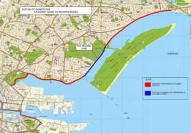
Published in Coastal Notes
Tagged under

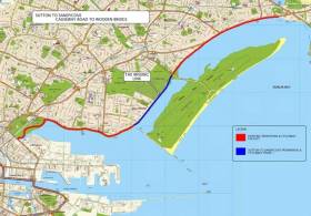
#S2S - The latest section of the Sutton to Sandycove (S2S) cycle route around Dublin Bay will not be opened till March due to delays on water main works, as Irish Cycle reports.

Once completed, the new cycle track — with mixed pedestrian and cyclist sections at junctions — will connect the pre-existing tracks between Sutton and the Bull Island causeway, and the route from Bull Bridge to East Wall Road.

As yet no section of the southside portion of the S2S has been completed, though a public consultation on the corridor from Sandymount/Merrion to Blackrock is currently open for public consultation till 31 January.

Irish Cycle has more on the story HERE.

Published in Dublin Bay

#DublinBay - An independent expert commissioned to evaluate local concerns over the new sea wall in Clontarf has recommended its height be reduced by at least 10 centimetres.

As previously reported on Afloat.ie, fears had grown among residents in the North Dublin Bay suburb that new flood defences constructed as part of the Sutton to Sandycove cycleway would exceed the height of the existing wall at the wooden bridge to the Bull Wall.

In response, Dublin City Council commissioned Dr Jimmy Murphy of University College Cork to examine the "technical information" that directed construction plans which residents claim breach previous promises over its maximum height and appearance.

But according to The Irish Times, while Dr Murphy's draft report says the wall's 4.25m height was "appropriate" in light of the council's long-term flood prevention criteria, there was no consistency as to the design plans and information used to inform such.

And for the time being, Dr Murphy suggests reducing the wall's "sea level rise" allowance by 10 to 20cm "at locations where the visual amenity is most affected".

The Irish Times has much more on the story HERE.

Published in Dublin Bay

About Dublin Port 

Dublin Port is Ireland’s largest and busiest port with approximately 17,000 vessel movements per year. As well as being the country’s largest port, Dublin Port has the highest rate of growth and, in the seven years to 2019, total cargo volumes grew by 36.1%.

The vision of Dublin Port Company is to have the required capacity to service the needs of its customers and the wider economy safely, efficiently and sustainably. Dublin Port will integrate with the City by enhancing the natural and built environments. The Port is being developed in line with Masterplan 2040.

Dublin Port Company is currently investing about €277 million on its Alexandra Basin Redevelopment (ABR), which is due to be complete by 2021. The redevelopment will improve the port's capacity for large ships by deepening and lengthening 3km of its 7km of berths. The ABR is part of a €1bn capital programme up to 2028, which will also include initial work on the Dublin Port’s MP2 Project - a major capital development project proposal for works within the existing port lands in the northeastern part of the port.

Dublin Port has also recently secured planning approval for the development of the next phase of its inland port near Dublin Airport. The latest stage of the inland port will include a site with the capacity to store more than 2,000 shipping containers and infrastructures such as an ESB substation, an office building and gantry crane.

Dublin Port Company recently submitted a planning application for a €320 million project that aims to provide significant additional capacity at the facility within the port in order to cope with increases in trade up to 2040. The scheme will see a new roll-on/roll-off jetty built to handle ferries of up to 240 metres in length, as well as the redevelopment of an oil berth into a deep-water container berth.

Dublin Port FAQ

Dublin was little more than a monastic settlement until the Norse invasion in the 8th and 9th centuries when they selected the Liffey Estuary as their point of entry to the country as it provided relatively easy access to the central plains of Ireland. Trading with England and Europe followed which required port facilities, so the development of Dublin Port is inextricably linked to the development of Dublin City, so it is fair to say the origins of the Port go back over one thousand years. As a result, the modern organisation Dublin Port has a long and remarkable history, dating back over 300 years from 1707.

The original Port of Dublin was situated upriver, a few miles from its current location near the modern Civic Offices at Wood Quay and close to Christchurch Cathedral. The Port remained close to that area until the new Custom House opened in the 1790s. In medieval times Dublin shipped cattle hides to Britain and the continent, and the returning ships carried wine, pottery and other goods.

510 acres. The modern Dublin Port is located either side of the River Liffey, out to its mouth. On the north side of the river, the central part (205 hectares or 510 acres) of the Port lies at the end of East Wall and North Wall, from Alexandra Quay.

Dublin Port Company is a State-owned commercial company responsible for operating and developing Dublin Port.

Dublin Port Company is a self-financing, and profitable private limited company wholly-owned by the State, whose business is to manage Dublin Port, Ireland's premier Port. Established as a corporate entity in 1997, Dublin Port Company is responsible for the management, control, operation and development of the Port.

Captain William Bligh (of Mutiny of the Bounty fame) was a visitor to Dublin in 1800, and his visit to the capital had a lasting effect on the Port. Bligh's study of the currents in Dublin Bay provided the basis for the construction of the North Wall. This undertaking led to the growth of Bull Island to its present size.

Yes. Dublin Port is the largest freight and passenger port in Ireland. It handles almost 50% of all trade in the Republic of Ireland.

All cargo handling activities being carried out by private sector companies operating in intensely competitive markets within the Port. Dublin Port Company provides world-class facilities, services, accommodation and lands in the harbour for ships, goods and passengers.

Eamonn O'Reilly is the Dublin Port Chief Executive.

Capt. Michael McKenna is the Dublin Port Harbour Master

In 2019, 1,949,229 people came through the Port.

In 2019, there were 158 cruise liner visits.

In 2019, 9.4 million gross tonnes of exports were handled by Dublin Port.

In 2019, there were 7,898 ship arrivals.

In 2019, there was a gross tonnage of 38.1 million.

In 2019, there were 559,506 tourist vehicles.

There were 98,897 lorries in 2019

Boats can navigate the River Liffey into Dublin by using the navigational guidelines. Find the guidelines on this page here.

VHF channel 12. Commercial vessels using Dublin Port or Dun Laoghaire Port typically have a qualified pilot or certified master with proven local knowledge on board. They "listen out" on VHF channel 12 when in Dublin Port's jurisdiction.

A Dublin Bay webcam showing the south of the Bay at Dun Laoghaire and a distant view of Dublin Port Shipping is here
Dublin Port is creating a distributed museum on its lands in Dublin City.
 A Liffey Tolka Project cycle and pedestrian way is the key to link the elements of this distributed museum together.  The distributed museum starts at the Diving Bell and, over the course of 6.3km, will give Dubliners a real sense of the City, the Port and the Bay.  For visitors, it will be a unique eye-opening stroll and vista through and alongside one of Europe’s busiest ports:  Diving Bell along Sir John Rogerson’s Quay over the Samuel Beckett Bridge, past the Scherzer Bridge and down the North Wall Quay campshire to Berth 18 - 1.2 km.   Liffey Tolka Project - Tree-lined pedestrian and cycle route between the River Liffey and the Tolka Estuary - 1.4 km with a 300-metre spur along Alexandra Road to The Pumphouse (to be completed by Q1 2021) and another 200 metres to The Flour Mill.   Tolka Estuary Greenway - Construction of Phase 1 (1.9 km) starts in December 2020 and will be completed by Spring 2022.  Phase 2 (1.3 km) will be delivered within the following five years.  The Pumphouse is a heritage zone being created as part of the Alexandra Basin Redevelopment Project.  The first phase of 1.6 acres will be completed in early 2021 and will include historical port equipment and buildings and a large open space for exhibitions and performances.  It will be expanded in a subsequent phase to incorporate the Victorian Graving Dock No. 1 which will be excavated and revealed. 
 The largest component of the distributed museum will be The Flour Mill.  This involves the redevelopment of the former Odlums Flour Mill on Alexandra Road based on a masterplan completed by Grafton Architects to provide a mix of port operational uses, a National Maritime Archive, two 300 seat performance venues, working and studio spaces for artists and exhibition spaces.   The Flour Mill will be developed in stages over the remaining twenty years of Masterplan 2040 alongside major port infrastructure projects.

Source: Dublin Port Company ©Afloat 2020.