


Displaying items by tag: drilling
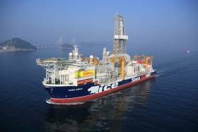
#MarineNotice - Providence Resources advises it intends to drill an exploration well in the Southern Porcupine Basin.
Operations were scheduled to begin today (Monday 3 July) to drill the well at a depth of 2,250 metres some 220km off the South West Coast of Ireland.
Drilling is expected to take 60 days to complete, subject to weather and operational delays.
The dynamically positioned drill ship Stena IceMax (Callsign 2FMJ5) will carry out the drilling, supported by platform supply vessels Sjoborg (Callsign OZ-2075), Edda Frende (Callsign LCOB) and Skandi Flora (Callsign LEVX). The emergency rapid response vessel is Esvagt Don (Callsign MZWQ6).
There will be a safety exclusion zone of 500m radius from the drill ship. Regular safety messages will be broadcast on VHF Channel 16 by Esvagt Don throughout the project. Radio navigation warnings will also be issued several times daily by the Irish Coast Guard.
All vessels, particularly those engaged in fishing, are requested to give the Stena IceMax and accompanying vessels a wide berth and keep a sharp lookout in the relevant areas.
Full details of the drilling area are included in Marine Notice No 28 of 2017, a PDF of which is available to read or download HERE.
Providence Divesting Almost One-Third Of Spanish Point Interest
#Oil&Gas - Providence Resources is divesting almost a third of its interest in its Spanish Point prospect, as The Irish Times reports.
The Irish oil and gas exploration company intends to sell off a 32% "non-operated interest" in the area off the coast of Co Clare, in the northern part of the Porcupine Basin, which has been shown to hold enormous reserves of oil.
Providence delayed its own exploration at Spanish Point earlier this year due to "unforeseen changes" to its joint venture at the well.
But drilling is now expected to take place in 2017 pending State approval.
The Irish Times has more on the story HERE.
Semisub Rig To Drill in Porcupine Basin

#Oil - The Blackford Dolphin semisubmersible drilling rig is expected to go to work off the south-west coast of Ireland next spring.
Offshore reports that Dolphin Drilling has negotiated the contract to appraise the Spanish Point prospect in the Porcupine Basin on behalf of Capricorn Ireland, subject to regulatory approval.
It will also drill early next year in British waters for MPX North Sea, with both contracts expected to last five months for a total revenue of €67 million.
The Porcupine Basin off Kerry has been identified as a source of enormous reserves of oil - after Petrel Resources announced the discovery of as much as one billion barrels of oil at the prospect late last year.
Marine Notice: Drilling in Corrib Gas Field

#MarineNotice - The latest Marine Notice from the Department of Transport, Tourism and Sport (DTTAS) advises that a drill ship will begin intervention work for Shell E&P Ireland Ltd on the Corrib Gas Field from late June to early July.
The vessel West Navigator (Call sign 3ERR2) is expected to be on location for a period of 45 days, weather permitting, to work on a series of wells. Co-ordinates are detailed in Marine Notice No 24 of 2013, a PDF of which is available to read or download HERE.
All mariners are reminded of the 'safety zone' in place around the Corrib Gas Field development, and especially those engaged in fishing are requested to give the West Navigator a wide berth of at least 500 metres.
The vessel will be listening on VHF Channel 16 throughout the project.
This follows notice of umbilical installation works between the Corrib Gas Field at the mainland that will continue till July, as previously reported on Afloat.ie.
South Coast Oil Appraisal 'Extremely Encouraging'

#COASTAL NOTES - Providence Resources has found light out with its first appraisal well off the south coast of Ireland, Offshore reports.
The company's semi-submersible GSF Arctic III drilled a well in 100m water to a depth of more than 2km on its Barryroe structure in the north Celtic Sea.
Indications of hydrocarbons were noted during the drilling, and further tests have confirmed the presence of 12.5m of 'net pay' (the thickness of rock that can deliver oil at a profitable rate) with as much as 87% hydrocarbon saturation.
The next stage will be a well flow test programme to determine whether future oil extraction can proceed.
“The confirmation of high quality light oil within a porous and potentially laterally extensive sandstone system is extremely encouraging," said technical director John O'Sullivan.
As previously reported on Afloat.ie, plans by Providence Rescources to prospect for oil pn the east coast off Dalkey Island have been met with fierce opposition by mainland residents and environmental groups.
Offshore has more on the story HERE.
Dolphin Group Comments on Dalkey Island Prospect

#DALKEY ISLAND PROSPECT - The Irish Whale and Dolphin Group (IWDG) has joined the chorus of opposition to the proposed oil and gas exploration off Dalkey Island in Co Dublin.
As previously reported on Afloat.ie, Providence Resources has applied for a foreshore licence to search for oil or gas about 6km out to sea on the Kish Bank Basin.
But the prospect has provoked a split in the local community over the potential risks and benefits, with many calling for a public enquiry into the licence before it is granted.
This evening an urgent meeting in Dun Laoghaire will address the public's concerns, which have been echoed by the IWDG.
"The Kish Bank and adjacent waters are important for cetaceans," said the group in a statement. "In addition, sightings of bottlenose dolphins have increased dramatically in the area following the presence of a group of three individuals since August 2010."
The IWDG is concerned about the potential effects on dolphins and porpoises that "could due to noise generated from the drilling process", noting that "there is little published data on the intensity and effects of sound generated by drilling".
Protest group Protect Our Coast has launched a online petition against the Dalkey Island Prospect citing concerns over the proximity of the drilling area to the mainland as well as the Special Protection Area of Dalkey Island, which is a haven for marine wildlife.
- Irish Whale and Dolphin Group
- IWDG
- Dalkey Island Prospect
- Coastal Notes
- Dalkey Island
- Dublin
- oil and gas
- exploration
- drilling
- Providence Resources
- foreshore licence
- Kish Bank Basin
- community
- Dun Laoghaire
- bottlenose dolphins
- Porpoises
- Cetaceans
- noise
- sound
- Protect Our Coast
- protest
- petition
- Special Protection Area
- marine wildlife
Oil and Gas Firm Issued Licence to Explore Off Dalkey Island
#POWER FROM THE SEA - Irish oil and gas firm Providence Resources has been awarded a licence to explore near Dalkey Island, the Irish Independent reports.
The standard licence issued by the Department of Communications, Energy and Natural Resources lasts for up to six years, split into two three-year phases.
Providence hopes to drill at least one well during the initial phase in the Kish Bank Basin, where previous exploration drilling confirmed the presence of oil suitable for petroleum production.
The group is also applying for a foreshore licence for the purpose of well site surveys and drilling operations.
As previously reported on Afloat.ie, Providence Resources is one of the 12 companies that were awarded 13 Licensing Options between them in the 2011 Atlantic Margin Licensing Round.
The Irish Independent has more on the story HERE.
Marine Notice: Drilling Off South Coast

#MARINE WARNING - The latest Marine Notice from the Department of Transport, Tourism and Sport (DTTAS) advises that offshore drilling has commenced off the south coast.
The semi-submersible drilling unit Arctic III (callsign YJSU9) will be drilling some 65km south of Roches Point, Co Cork, for a period of approximately three months.
The drilling unit will have a dedicated stand-by safety vessel and supply vessel, both listening on VHF channel 16 throughout the project.
All vessels, particularly those involved in fishing, are urged to give the drilling unit and its handling vessels a wide berth of at least 500 metres and to keep a sharp lookout in the area.
Full location co-ordinates and further details are included in Marine Notice No 53 of 2011, a PDF of which is available to read and download HERE.
Corrib Drilling Advisory to Vessels
The Department of Transport's latest marine notice advises on the start of offshore drilling operations by Shell Ireland at the Corrib gas field in Co Mayo.
Drilling is scheduled to begin on or around 13 April, to last for approximately four months. The notice gives details of all planned locations by latitude and longitude.
A safety zone is in place around the gas field development, and all vessels - especially fishing boats - are requested to give the drilling unit a wide berth of at least 500m and keep a strong lookout in the vicinity.
A PDF of Marine Notice No 19 of 2011 is available to read/download HERE.


 for a “Student Safe” water safety")


 for the new skiff and builder Patsy Whelan Jnr.")


 with his exuberant crew as they celebrate being overall winners of Howth Wave 2024")
