


Displaying items by tag: drone
Drone-Eye View Adds New Dimension To Sailing Directions
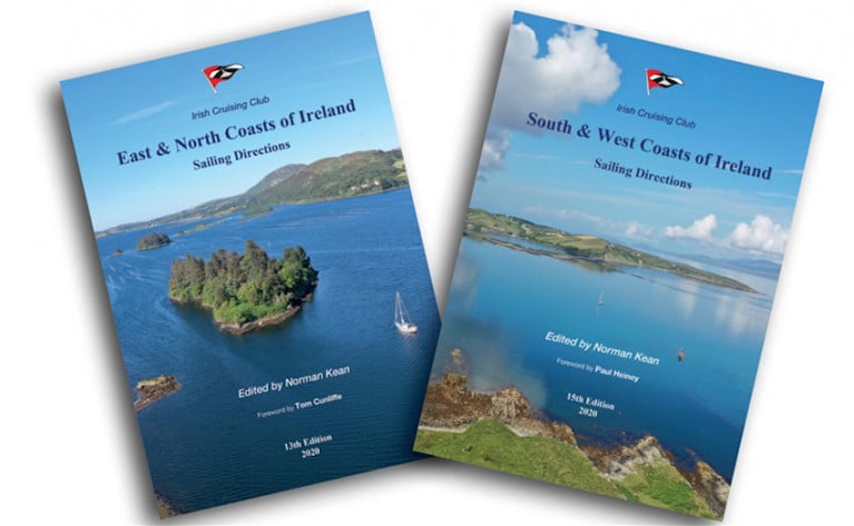
For 90 years, the Irish Cruising Club’s Sailing Directions have been the standard text on small-craft pilotage of the Irish coast.
As Afloat contributor Lorna Siggins wrote in her review for The Irish Times: “Approach any port without these navigational directions on deck at one’s peril.”
And now the latest editions for 2020 make spectacular use of drone photography to add a new dimension.
Norman Kean and Geraldine Hennigan went cruising around Ireland in 2019 gathering information on many recent changes, and taking 1,400 stunning drone pictures.
Norman will present some of his remarkable photography at the upcoming Irish Sailing Cruising Conference, where three lucky delegates will each receive a copy of either the East & North or South & West guide or the Cruising Ireland companion guide as spot prizes.
The new editions are available now from ICC Publications or your local chandlery.
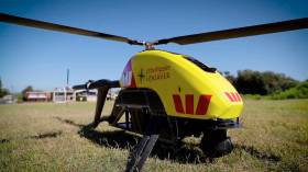
Aviation First Across Atlantic Corridor With Drone Doctor Flight to Aran Islands
An aviation “first” has been recorded on the Atlantic corridor between Connemara and the Aran Islands with the delivery of medication by a drone writes Lorna Siggins
The Wingcopter 178 Heavy Lift drone flew diabetes prescription medications and a collection of a patient blood sample almost 22 km across from Connemara airport in Indreabhán to the largest Aran island of Inis Mór last Friday.
The return leg was slightly shorter at 21.6km, and both flights were completed on a single set of batteries, amounting to 32 minutes of flight time.
The DiabetesDrone project was led by NUI Galway (NUIG), and run in partnership with several industry experts and stakeholders.
It was supported by the Irish Aviation Authority and took place between commercial flights to and from Connemara and the Aran islands - showing that future deliveries of this kind could take place within “planned drone corridors”, according to NUIG.
The project participants noted that it is “crucial that people with diabetes have access to their lifesaving medicine at all times, which is often challenging in remote geographic regions and in times of natural disasters”.
“Recent severe weather events, including storms Emma and Ophelia, demonstrated a clear need to develop the capability to deliver insulin and other critical medications (such as glucagon) in times of crisis,” they noted.
NUIG professor of medical device technology Prof Derek O’Keeffe said that island and rural communities could become isolated for days after a severe weather event and might need emergency medicine deliveries.
“To date, medical drones have demonstrated success, for example in delivering blood, defibrillators and human organs for transplant. This #DiabetesDrone project represents another milestone in the use of drones to improve patient care,” he said.
Aran island GP Dr Marian Broderick said that the drone technology offered "endless possibilities" for island communities.
The drone supplied by Survey Drones Ireland was equipped with an insulated parcel delivery box for the payload. The devices reach destinations of up to 100 km distance in less than an hour.
The drone was launched from Connemara Airport using a combination of software - one for the pre-flight checklist and one for the mission flight, and was connected via Vodafone Ireland’s “Internet of Things” network, and flew a pre-planned flight path using “Q Ground Control” software.
‘Little Ripper’ Drone Rescues Australian Swimmers In World First
#Drone - Beach lifeguards in Australia used a drone to rescue two swimmers in distress in what RTÉ News hails as a world first.
The ‘Little Ripper’ was launched from Lennox Head near Brisbane earlier today (Thursday 18 January) as lifeguards were readying for a training session in the use of such drones in rescue scenarios.
When two teenagers were caught in a swell outside the safety flags, the drone flew out to the swimmers and dropped an inflatable ‘rescue pod’ and were pulled back to shore in just over a minute.
The rescue was a first for the remote-piloted mini aircraft that’s more commonly used to spot sharks off Brisbane’s popular beaches.
Drones have also been hailed as a potential revolution for coastal rescues in Ireland, as previously reported on Afloat.ie.
Drone used in rescue of teens sucked out to sea in Australia. pic.twitter.com/1BVpoQI0TA
— RTÉ News (@rtenews) January 18, 2018
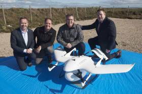
Irish Startup Scoops European Commission Prize at European Satellite Navigation Competition 2017

Donegal based startup, DroneSAR Ltd has won the European Commission prize announced last night (7 November 2017) in Tallinn, Estonia at the awards ceremony for the 14th European Satellite Navigation Competition (ESNC) winners. DroneSAR Ltd were awarded this prize for the development of software which transforms standard “off-the-shelf” drone and mobile device pairings into enhanced search and rescue (SAR) data transmission technology that will save lives.
The European Commission Prize - the Copernicus Masters Services Challenge - is one of a range of challenges and prizes on offer to the 321 finalists in the ESNC competition. It is awarded for innovative uses of the European Commission operated Copernicus program products. The Copernicus program is a European Union Programme aimed at developing European information services based on satellite Earth Observation data and implemented in partnership with Member States, the European Space Agency (ESA) and a number of other European organisations.
DroneSAR Ltd were presented with a cheque from the European Commission, which is in addition to their award as Ireland Region Winner. The Ireland Region Competition for the annual ESNC awards has been organised and sponsored by National Space Centre Ltd since 2012.
DroneSAR Ltd is the brainchild of it’s four co-founders who each possess expertise and skill-sets specific to the world of drone technology, network and satellite communication and SAR coordination and emergency response.
CEO Oisin McGrath said “DroneSAR makes it possible to use affordable, “off-the-shelf” drone technology to expedite successful outcomes during emergency response incidents. It delivers the right data to the right people at the right time when agencies are faced with time and resource constraints. We are delighted to have won this award from the European Commission.
Each member of the DroneSAR team has contributed to realise a software product that will play a major part in ensuring that emergency response time-frames, incident coordination, decisions and successful outcomes will be realised across all sectors of the emergency response and humanitarian relief environment.”
To deliver the service, DroneSAR Ltd has partnered with leading outdoor pursuit software providers Viewranger, global maritime distress software company SafeTRX and medical distress location software, Medimee, all of which will allow victim position data to be sent to DroneSAR software for automatic flight to the location.
Rory Fitzpatrick, CEO National Space Centre said “This is worthy recognition for an outstanding product that has both commercial and lifesaving potential. We are incredibly proud to see this young Irish company perform so strongly on the international stage.”
National Space Centre Ltd is based at Elfordstown Earthstation, Midleton and delivers uplink and downlink services to domestic and international teleport and satellite communications markets.
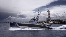
#Navy - The future of maritime defence is here – in the form of a torpedo-wielding drone boat called Seagull.
The video below from Vocativ shows a prototype of the 40ft vessel in action, displaying its stealthy manoeuvrability on the water.
Watch video!Developed by an Israeli company, the Seagull is intended for the most dangerous tasks at sea such as minesweeping or anti-submarine missions.
Effectively, just a handful of such boats could replace the work currently done by teams of US Navy destroyers and long-range aircraft.
Popular Mechanics has more on the story HERE.
Drone Technology to Cut Delivery Costs to Ships
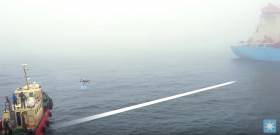
In the shipping and tanker business, it can be hard to predict far in advance which port will be called to next and even when in port, it can be complicated and expensive to deliver items to vessels as they are not alongside the quay. Drone technology offers a solution to this and Maersk Group have been trialling it at sea.
Drones could cut time and costs for deliveries and inspections – but shipping lines say they must be reliable and absolutely safe. Maersk Tankers is testing delivery to vessels on drones that have been certified for explosive environments.
Costs for a barge are on average USD 1,000 and can be higher. That means, drone use could with the current payload bring potential savings of USD 3,000-9,000 per vessel per year, Maersk Tankers estimates.
Wicklow Aerial Video Captures Garden Coastline & Stunning Sea Views

#wicklow – No surprise that this County Wicklow from the air vid features the Garden County's stunning coastline but Skycam Ireland's crisp footage via drone goes so much further to capture incredible coastal scenery right on the Capital's doorstep.
There is spectacular views of rolling green hills and a weather-beaten rocky coastline. There's castles and towers stationed on every headland, giving you the feeling of flying through a scene from 'Lord of the Rings'.
Nearby Dublin Bay sailors will instantly recognise familiar landmarks including Wicklow Head, its prominent lighthouses and Wicklow harbour itself, the home of the Round Ireland yacht race. The four–minute video includes coastal scenes of Killiney Bay and Bray Head and shots over water along an historically important stretch of Kilcoole beach.
There are many more water-based shots featured too including Wickow's amazing lakes, waterfalls and watch out for the cute seal!
We hope Skycam are planning a 2015 verison, if so Afloat.ie recommends a flight over Greystones Harbour and Marina to capture the country's newest coastal marina facility.


 but will now be delayed until Saturday and in advance of the Islay Festival")
 passes Copper Point Light at Long Island in the first 2024 summer sailing season at Schull Harbour Sailing Club")


 with his exuberant crew as they celebrate being overall winners of Howth Wave 2024")


