Menu

Ireland's sailing, boating & maritime magazine

Inland afloat headers


Displaying items by tag: Belfast Lough

#Decommissioning - For many UK ports writes EnergyVoice, developing the facilities needed for large-scale decommissioning projects is a quest they are just embarking on.

But for the Belfast based Harland and Wolff (H&W) shipyard, the asset it describes as the Holy Grail of ship decommissioning has been in place for many years.

The yard that built the Titanic has one of the biggest dry docks in the world, at 556metres in length and 93metres wide, about the same area as seven Wembley football pitches.

David McVeigh, general manager, sales marketing and business development, said the dock is an important feather in Belfast’s cap.

Its thick, high walls are a physical barrier between the surrounding environment and oils and other contaminants that could accidentally spill. It keeps H&W in line with the 1992 Basel Convention on the transfer and disposal of hazardous waste materials.

Ports with piers or slipways may have well thought out safeguards against spills, but from an environmental viewpoint, they cannot offer the same level of assurance on decommissioning.

H&W also has a waste management licence for ship and offshore unit recycling, not to mention the two giant yellow cranes, Samson and Goliath.

Mr McVeigh said H&W’s offering means it should appeal to those who take their environmental responsibilities seriously. He said: “Our facilities are huge. We have big quaysides and one of the biggest dry docks in the world.

It means we can offer environmentally credible solutions. “Some customers would place the economics above the environmental impact. We’ll still see vessels going outside EU to places that are not as concerned about environmental issues as we are. If someone is looking for a cheap solution they’re not going to come to us, but if someone values the environment, we are well suited to deliver.”

Mr McVeigh said that while decommissioning is not a big earner for H&W, the yard will be “ready to go” when the market kicks into gear.

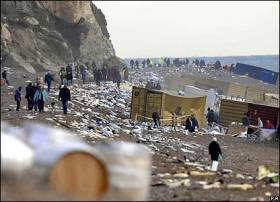
To date, perhaps the biggest decommissioning job H&W has handled was that of the MSC Napoli container ship (see Belfast coverage photo), which was beached in Lyme Bay in the English Channel in 2007. The job could quite easily serve as a dress rehearsal for the decommissioning of a floating production, storage and offloading vessel in the coming decades.

Dismantling topsides could be part of the mix, too. Mr McVeigh said H&W had carried out a dock appraisal to demonstrate that Allseas’ mammoth Pioneering Spirit, which will remove Shell’s Brent Delta platform in summer 2017, could work within the harbour’s existing facilities.

For more and also manufacturing installation project click here.

Published in Belfast Lough

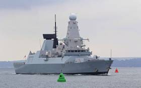
#NavalVisits - The Royal Navy’s HMS Duncan was among a fleet of NATO warships that sailed into Belfast Lough on Friday 4 November, as ITV News reports.

The Type 45 Destroyer, only the second of its kind in Northern Ireland’s waters, is part of a four-ship fleet comprising frigates from Spain, Portugal and Germany that had been scheduled to visit last month.

However, they were diverted to monitor a number of Russian warships passing through British waters en route to Syria.

The visit this weekend followed reports that Russian submarines had been tracked through the Irish Sea in recent weeks, as previously covered on Afloat.ie.
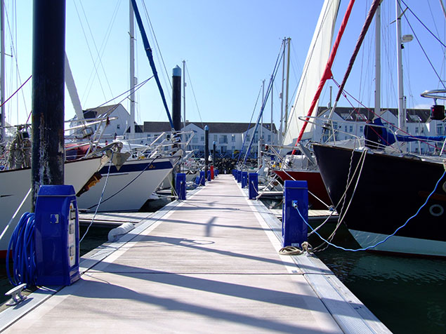
Published in Naval Visits

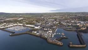
Sponsored content: Carrickfergus Marina situated on the northern shore of Belfast Lough is making the most of the current Euro-Sterling exchange rates to highlight its Five Gold Anchor facility, with 300 fully serviced berths, to sailors and boat owners considering a change of berth on the East Coast.

The County Antrim marina has a choice of flexible contracts, and new customers taking out their first contract will get their first month free on a complimentary basis. In particular, its Winter Berthing Contract is £112.20 per metre for the six month period from 1 October 2016 till 31 March 2017.

Those coming in from 1 November onwards will be given pro-rata of this price, and again each new customer will receive the same discount.

Facilities at Carrickfergus

Customers at Carrickfergus Marina can avail of a boat yard on site, with a 40-ton travel hoist, chandlery and guardianage services are also provided. There is also an onsite brokerage service, and the long-established sailing club, with an active racing and cruising section. Club racing at Carrickfergus runs from Easter through to mid-December.

Twenty-four-hour security should give you peace of mind, while the marina also provides a dedicated berth for contract holders, a post-holding service for those on the go, and free Wi-Fi to stay connected. An extensive site refurbishment is currently underway to revamp the marina’s electrics and access systems, and a new family bathroom with separate shower is due to open in late winter.

Carrickfergus Marina 
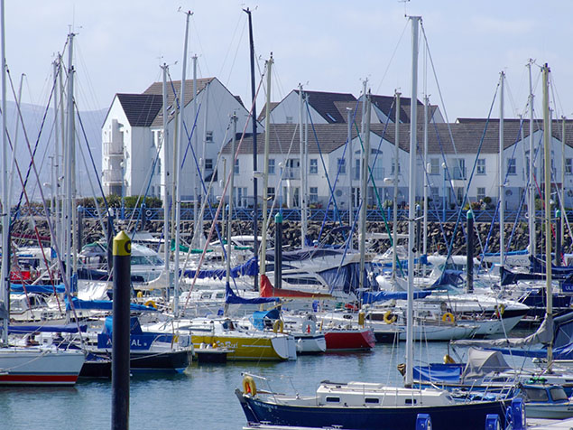
Carrickfergus Marina is a Five Gold Anchor facility, with 300 fully serviced berths

Travelling to Carrickfergus

By car: Carrickfergus Marina is just over two hours from Dublin via the M1 and A1 to Belfast, then the M5 and A2 north along Belfast Lough. Car parking is available adjacent to the east and west gates into the marina basin.

By bus/train: The marina can be reached from Dublin in around three hours, by coach from Dublin to Belfast city centre and then local services to the main road outside the marina office, or by rail from Dublin Connolly to Belfast Central and local train (approx 25 minutes) to Carrickfergus station, a three-minute walk from the marina.

Carrickfergus as a destination

Spend a weekend, or a week, in Carrickfergus exploring the town’s unique local heritage, including its Norman castle and renowned St Nicholas’ Church, both dating from the 12th century, as well as the local heritage museum and Flame Gasworks Museum – Ireland’s sole surviving coal gasworks, one of only three left in the British Isles.

Go for a swim or a workout in the state-of-the-art gym at the Amphitheatre Leisure Centre; browse the selection of boutique shops in the town centre; and enjoy a meal in one of the many fine local restaurants — all located within a five-minute walk of the marina.

To keep the family entertained, the Omniplex multiscreen cinema across the road which also offers reduced-price child-friendly and ASD-friendly showings during holidays and weekends, and there is a brand new soft-play centre two minutes’ drive away.

No spare cabin for friends or family? They can stay at one of the town’s comfortable local hotels. Premier Inn is right across the road, while Dobbins Inn is a five-minute walk on the town’s main street, and the four-star Loughshore Hotel is a two-minute drive from the marina.

Carrickfergus MarinaCarricfergus marina – the County Antrim marina has a choice of flexible contracts, and new customers taking out their first contract will get their first month free on a complimentary basis

Contact details are as follows: 

Carrickfergus Marina, Mid & East Antrim Borough Council, 3 Quayside, Carrickfergus, BT38 8BJ Telephone: 028 9336 6666

Website: www.midandeastantrim.gov.uk

Published in Irish Marinas

#TitanicBrexit - Belfast’s Titanic Quarter, which is home to Northern Ireland’s and Europe's most popular tourist attraction, has reported losses for last year of £333,111 (€383,329), newly filed accounts show.

Titanic Island Limited, which controls the group of companies working in the quarter, said pretax losses narrowed from £1.16 million in 2014. The group previously reported a £68,000 loss for 2014, down from £33.9 million in 2013. It said the previous year’s results had been restated due to a transition to the FRS 102 reporting standard.

Turnover totalled £10.9 million for 2015 with operating profit rising from £1.96 million to £2.49 million.

For more on the potential of the Brexit impact to one of the world’s largest urban-waterfront regeneration projects, the Irish Times has a report by clicking here.

Published in Titanic

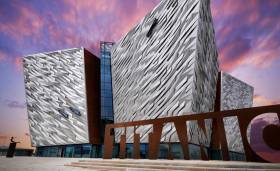
#TitanicBelfast - Titanic Belfast is Europe's leading tourist attraction, after scooping a top gong at a major industry awards ceremony.

Paying tribute to the ill-fated ocean liner RMS Titanic and its history in the city, the Belfast Lough visitor centre took the award for Europe's Leading Visitor Attraction at the World Travel Awards in Sardinia last night (Monday 5 September), according to TheJournal.ie.

The Guinness Storehouse, Buckingham Palace and the Colosseum in Rome were among the renowned tourist hotspots beaten to the prize, the first for Northern Ireland in the history of the awards.

As previously reported on Afloat.ie, the four-year-old venue saw a 2% growth in visitor numbers in the 12 months before March this year, along with a 7% growth in revenues.

Published in Titanic

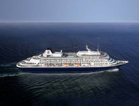
#HALcall – Holland America Line’s Prinsendam berthed in Belfast Harbour this morning as part of a 28 Day Celtic & Bourgundian Explorer Cruise, writes Jehan Ashmore.

This was the second call of HAL's Prinsendam to Belfast this season as she called in July. Overall, this morning's call was her 14th visit to the port having berthed at the Stormont cruise wharf. She has a capacity for more than 766 passengers and 460 crew.

Prinsendam at under 40,000 gross tonnage is the smallest of the HAL fleet which now has a newcomer, Koningdam, just shy of 100,000 gross tonnage. She was named in May as the first of the 'Pinnacle' class, the largest ever built for the US based operator, part of the Carnival Corporation. The newbuild can take a maximum of 3,200 passengers and over 1,000 crew.

Today’s call of Prinsendam represents the 29 caller and last of this month alone to Belfast. Asides, HAL, among the cruise operators they include Princess, Celebrity, Cunard, Silversea, Majestic, and Fred Olsen.

The port is to host almost 145,000 cruise visitors this season as the harbour is the principle gateway to the attractions of city and Northern Ireland.

Prinsendam had set off from Dublin, where she overnighted at Ocean Pier, within Alexandra Basin, where another fleetmate, Rotterdam had called earlier this month.
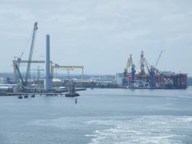
Published in Cruise Liners

#HeavyLiftVessel - Dutch marine speciliat, Van Oord's heavy lift-vessel, HLV Svanen arrived recently to Belfast Harbour, following installing the final wind turbine foundation at the Burbo Bank Extension wind farm in Liverpool Bay.

The 1990 built heavy lift installation vessel is moored at Harland and Wolff's Commissioning Quay. The sheerleg catamaran craft is to undergo repairs and outfitting at the marine engineering facility and shipyard, ahead of its next contract.

The HLV is taller than H&W's gantry crane Samson, which stands at 106m from the rails. Svanen has an impressive maximum lift capacity of 8,700 tonnes (excluding rigging; 8,200 tonnes including rigging). 

To put this into perspective, the metal structure of the Eiffel Tower weighs 7,300 tonnes!

Published in Power From the Sea

#MostPowerful - The world’s most powerful wind turbine blades continue to ‘breeze’ into Belfast Harbour, as part of a project to develop the Burbo 2 offshore wind farm on the Irish Sea as previously reported on Afloat. The blades – plus their 88m high towers are visible from across much of the city.

The first six massive 80m long blades – the equivalent length of nine double decker London buses – have arrived in Belfast Harbour’s offshore wind terminal from the Isle of Wight. The completed wind farm will provide enough renewable electricity for 230,000 homes.

Each blade weighs 35 tonnes and the turbines, which will be assembled in Belfast Harbour, will ‘sweep’ an area larger than the London Eye (21,124 sq m). During this phase of the project, 32 turbines will be assembled in Belfast. The blades are manufactured in the UK by MHI Vestas Offshore Wind.

After the turbines are assembled in Belfast they will be transported on a state-of-the-art jack up vessel which will install them on the seabed, just off the coast of Liverpool. The wind farm will cover 40km2, the same area of almost 6,000 Premiership football pitches.

Once operational, the tip height of the blade and turbine will be almost 200m. The record level of energy produced from just one turbine in a 24-hr period is 192 MWh – the same amount of energy produced by 22,600 litres of oil.

The blades, which were designed, tested and manufactured at the MHI Vestas on the Isle of Wight, will be the first UK built blades to be installed at a British offshore wind power plant.

Published in Power From the Sea

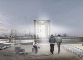
#MewIslandOptic - A rare lighthouse lens that helped guide ships into Belfast Lough for more than a century is to get a new home on the city's waterfront, as the Belfast Telegraph reports.

The optic from Mew Island Lighthouse, one of Ireland's tallest lights, will be housed in a much more accessible structure designed by architects Hall McKnight.

The firm fended off 11 other tenders to win the commission by the Titanic Foundation for the new monument to Northern Ireland's seafaring traditions, one that's intended to last for at least another 100 years.

With a design echoing a lighthouse lantern room, the structure will house what's believed by many to be the largest Fresnel lens, produced in Paris by master glassmakers in 1887.

The Belfast Telegraph has more on the story HERE.

Published in Lighthouses

#WindFarm - Blades for a wind-farm in the Irish Sea have begun to arrive in Belfast Harbour reports ReNews.

The blades are for the MHI Vestas V164 8MW turbines destined for Dong Energy’s 256MW Burbo 2 offshore wind-farm in the Irish Sea.

The 80-metre blades for the 32 machines have been manufactured at MHI Vestas's factory on the Isle of Wight.

The turbines will be loaded out in September by A2Sea.

Bladt Industries and EEW are responsible for the project’s foundations, which are currently being installed by Dutch company Van Oord.

Published in Power From the Sea
Page 17 of 31

General Information on using Waterways Ireland inland navigations

Safety on the Water

All users of the navigations are strongly recommended to make themselves aware of safety on the water for whatever activity they are involved in and to read the advice offered by the various governing bodies and by:

The Dept. of Transport, Ireland: www.gov.ie/transport and The Maritime and Coastguard Agency, UK, The RNLI – Water Safety Ireland for information in terms of drowning prevention and water safety.

Registration of Vessels

All vessels using the Shannon Navigation, which includes the Shannon-Erne Waterways and the Erne System must be registered with Waterways Ireland. Only open undecked boats with an engine of 15 horsepower or less on the Shannon Navigation, and vessels of 10 horsepower or less on the Erne System, are exempt. Registration is free of charge.

Craft registration should be completed online at: https://www.waterwaysireland.org/online-services/craft-registration

Permits for use of the Grand and Royal Canals and the Barrow Navigation

All vessels using the Grand and Royal Canals and the Barrow Navigation must display appropriate valid Permit(s) i.e A Combined Mooring and Passage Permit (€126) and if not intending to move every five days, an Extended Mooring Permit (€152).

Permit applications should be completed online at: https://www.waterwaysireland.org/online-services/canal-permits

Passage on the Royal and Grand Canals – Dublin Area

For boat passage through the locks east of Lock 12 into / out of Dublin on either the Royal or Grand Canals, Masters are requested to contact the Waterways Ireland Eastern Regional Office (M-F 9.30am-4.30pm) on tel: +353(0)1 868 0148 or email [email protected] prior to making passage in order to plan the necessary lock-keeping assistance arrangements.

On the Grand Canal a minimum of two days notice prior to the planned passage should be given, masters should note that with the exception of pre-arranged events, a maximum of 2 boats per day will be taken through the locks, travelling either east or west.

Movements in or out of the city will be organised by prior arrangement to take place as a single movement in one day. Boaters will be facilitated to travel the system if their passage is considered to be safe by Waterways Ireland and they have the valid permit(s) for mooring and passage.

Newcomen Lifting Bridge

On the Royal Canal two weeks’ notice of bridge passage (Newcomen Lifting Bridge) is required for the pre-set lift date, and lock assistance will then also be arranged. A minimum of 2 boats is required for a bridge lift to go ahead.

Waterways Ireland Eastern Regional Office (Tel: +353(0)1 868 0148 or [email protected] ) is the point of contact for the bridge lift.

A maximum number of boats passing will be implemented to keep to the times given above for the planned lifts (16 for the Sat / Sun lifts & 8 for the weekday lifts). Priority will be given on a first come first served basis.

On day of lift, boaters and passengers must follow guidance from Waterways Ireland staff about sequence of passage under bridge & through Lock 1, and must remain within signed and designated areas.

Events Held on the Waterways

All organised events taking place on the waterways must have the prior approval of Waterways Ireland. This is a twelve week process and application forms must be accompanied with the appropriate insurance, signed indemnity and risk assessment. The application should be completed on the Waterways Ireland events page at :

https://www.waterwaysireland.org/online-services/event-approval

Time Limits on Mooring in Public Harbours

On the Shannon Navigation and the Shannon-Erne Waterway craft may berth in public harbours for five consecutive days or a total of seven days in any one month.

On the Erne System, revised Bye Laws state that: No master or owner shall permit a vessel, boat or any floating or sunken object to remain moored at or in the vicinity of any public mooring, including mooring at any other public mooring within 3 kilometres of that location, for more than 3 consecutive days and shall not moor at that same mooring or any other public mooring within 3 kilometres of that location within the following 3 consecutive days without prior permission by an authorised official.

Winter Mooring on the Shannon Navigation and Shannon Erne Waterway

Winter mooring may be availed of by owners during the period 1 Nov to 31 Mar by prior arrangement and payment of a charge of €63.50 per craft. Craft not availing of Winter Mooring must continue to comply with the “5 Day Rule”. Winter Mooring applications should be completed online at : https://www.waterwaysireland.org/online-services/winter-moorings-booking

Owners should be aware that electricity supply and water supply to public moorings is disconnected for the winter months. This is to protect against frost damage, to reduce running costs and to minimise maintenance requirements during the winter months.

Vessel owners are advised that advance purchasing of electricity on the power bollards leading up to the disconnection date should be minimal. Electricity credit existing on the bollards will not be recoverable after the winter decommissioning date. Both services will be reinstated prior to the commencement of the next boating season.

Smart Cards

Waterways Ireland smart cards are used to operate locks on the Shannon Erne Waterway, to access the service blocks, to use the pump-outs along the navigations, to avail of electrical power at Waterways Ireland jetties.

Berthing in Public Harbours

Masters are reminded of the following:

  • Equip their vessel with mooring lines of appropriate length and strength and only secure their craft to mooring bollards and cleats provided for this purpose.
  • Ensure the available berth is suitable to the length of your vessel, do not overhang the mooring especially on finger moorings on floating pontoon moorings.
  • Ensure mooring lines, electric cables and fresh water hoses do not create a trip hazard on public jetties for others users.
  • Carry sufficient fenders to prevent damage to your own vessel, other vessels and WI property.
  • Allow sufficient space between your vessel and the vessel ahead /astern (c.1m) for fire safety purposes and /or to recover somebody from the water.
  • Do not berth more than two vessels side by side and ensure there is safe access/egress at all times between vessels and onto the harbour itself.
  • Do not berth in such a way to prevent use of harbour safety ladders, slipways or pump-outs.
  • Do not allow the bow of your vessel to overhang the walkway of a floating mooring thus creating a hazard for others with an overhanging anchor or bow fendering.
  • Animals are not allowed to be loose or stray at any time.
  • Harbour and jetty infrastructure such as railings, power pedestals, fresh water taps, electric light poles, safety bollards, ladders etc are not designed for the purpose of mooring craft , they will not bear the strain of a vessel and will be damaged.
  • At Carrybridge on the Erne System, Masters of vessels are not permitted to use stern on mooring. Masters of vessels must use the mooring fingers for mooring of vessels and for embarkation / disembarkation from vessels.

Passenger Vessel Berths

Masters of vessels should not berth on passenger vessel berths where it is indicated that an arrival is imminent. Passenger vessels plying the navigations generally only occupy the berths to embark and disembark passengers and rarely remain on the berths for extended periods or overnight.

Lock Lead-in Jetties

Lead-in jetties adjacent to the upstream and downstream gates at lock chambers are solely for the purpose of craft waiting to use the lock and should not be used for long term berthing.

Vessel Wake

Vessel wake, that is, the wave generated by the passage of the boat through the water, can sometimes be large, powerful and destructive depending on the hull shape and engine power of the vessel. This wake can be detrimental to other users of the navigation when it strikes their craft or inundates the shoreline or riverbank. Masters are requested to frequently look behind and check the effect of their wake / wash particularly when passing moored vessels, on entering harbours and approaching jetties and to be aware of people pursuing other activities such as fishing on the riverbank.

Speed Restriction

A vessel or boat shall not be navigated on the Shannon Navigation at a speed in excess of 5 kph when within 200 metres of a bridge, quay, jetty or wharf, when in a harbour or canal or when passing within 100 metres of a moored vessel or boat.

Vessels navigating the Shannon-Erne Waterway should observe the general 5 kph speed limit which applies along the waterway. This is necessary in order to prevent damage to the banks caused by excessive wash from vessels.

Vessels navigating the Erne System should observe the statutory 5kt / 6mph / 10kph speed limit areas.

A craft on the Royal and Grand canals shall not be navigated at a speed in excess of 6km per hour.

A craft on the Barrow Navigation shall not be navigated at a speed in excess of 11km per hour except as necessary for safe navigation in conditions of fast flow.

Bank Erosion

Narrow sections of all the navigations are particularly prone to bank erosion due to the large wash generated by some craft. Masters are requested to be vigilant and to slow down to a speed sufficient to maintain steerage when they observe the wash of their craft inundating the river banks.

Unusual Waterborne Activity

Unusual waterborne vessels may be encountered from time to time, such as, hovercraft or amphibious aircraft / seaplanes. Masters of such craft are reminded to apply the normal “Rule of the Road” when they meet conventional craft on the water and to allow extra room to manoeuvre in the interest of safety.

Sailing Activity

Mariners will encounter large numbers of sailing dinghies from late June to August in the vicinity of Lough Derg, Lough Ree and Lower Lough Erne. Sailing courses are marked by yellow buoys to suit weather conditions on the day. Vessels should proceed at slow speed and with due caution and observe the rules of navigation when passing these fleets, as many of the participants are junior sailors under training.

Rowing

Mariners should expect to meet canoes and vessels under oars on any part of the navigations, but more so in the vicinity of Athlone, Carrick-on-Shannon, Coleraine, Enniskillen and Limerick. Masters are reminded to proceed at slow speed and especially to reduce their wash to a minimum when passing these craft as they can be easily upset and swamped due to their very low freeboard and always be prepared to give way in any given traffic situation.

Canoeing

Canoeing is an adventure sport and participants are strongly recommended to seek the advice of the sport’s governing bodies i.e Canoeing Ireland and the Canoe Association of Northern Ireland, before venturing onto the navigations.

Persons in charge of canoes are reminded of the inherent danger to these craft associated with operating close to weirs, sluice gates, locks and other infrastructure particularly when rivers are in flood and large volumes of water are moving through the navigations due to general flood conditions or very heavy localised precipitation e.g. turbulent and broken water, stopper waves. Shooting weirs is prohibited without prior permission of Waterways Ireland.

Canoeists should check with lockkeepers prior entering a lock to ensure passage is done in a safe manner. Portage is required at all unmanned locks.

Canoe Trail Network – "Blueways"

Masters of powered craft are reminded that a canoe trail network is being developed across all navigations and to expect more organised canoeing along these trails necessitating slow speed and minimum wash when encountering canoeists, rowing boats etc

Rockingham and Drummans Island Canals – Lough Key

It is expected that work on Rockingham and Drummans Island Canals on Lough Key will be completed in 2021. Access to these canals will be for non-powered craft only, eg canoes, kayaks, rowing boats.

Fast Powerboats and Personal Watercraft (Jet Skis)

Masters of Fast Powerboats (speed greater than 17kts) and Personal Watercraft (i.e.Jet Skis) are reminded of the inherent dangers associated with high speed on the water and especially in the confines of small bays and narrow sections of the navigations. Keeping a proper look-out, making early alterations to course and /or reducing speed will avoid conflict with slower vessels using the navigation. Personal Watercraft are not permitted to be used on the canals.

Towing Waterskiers, Wakeboarders, Doughnuts etc

Masters of vessels engaged in any of these activities are reminded of the manoeuvring constraints imposed upon their vessel by the tow and of the added responsibilities that they have to the person(s) being towed. These activities should be conducted in areas which are clear of conflicting traffic. It is highly recommended that a person additional to the master be carried to act as a “look-out” to keep the tow under observation at all times.

Prohibition on Swimming

Swimming in the navigable channel, particularly at bridges, is dangerous and is prohibited due to the risk of being run over by a vessel underway in the navigation.

Age Restrictions on operating of powered craft

In the Republic of Ireland, Statutory Instrument 921 of 2005 provides the legal requirements regarding the minimum age for operating of powered craft. The Statutory Instrument contains the following requirements:

- The master or owner of a personal watercraft or a fast power craft shall take all reasonable steps to ensure that a person who has not attained the age of 16 years does not operate or control the craft

- The master or owner of a pleasure craft powered by an engine with a rating of more than 5 horse power or 3.7 kilowatts shall take all reasonable steps to ensure that a person who has not attained the age of 12 years does not operate or control the craft.

Lifejackets and Personal Flotation Devices (PFDs)

Lifejackets and PFD’s are the single most important items of personal protective equipment to be used on a vessel and should be worn especially when the vessel is being manoeuvred such as entering / departing a lock, anchoring, coming alongside or departing a jetty or quayside.

In the Republic of Ireland, Statutory Instrument 921 of 2005 provides the legal requirements regarding the wearing of Personal Flotation Devices. The Statutory Instrument contains the following requirements:

- The master or owner of a pleasure craft (other than a personal watercraft) shall ensure, that there are, at all times on board the craft, sufficient suitable personal flotation devices for each person on board.

- A person on a pleasure craft (other than a personal watercraft) of less than 7 metres length overall shall wear a suitable personal flotation device while on board an open craft or while on the deck of decked craft, other than when the craft is made fast to the shore or at anchor.

- The master or owner of a pleasure craft (other than a personal watercraft) shall take all reasonable steps to ensure that a person who has not attained the age of 16 years complies with paragraph above.

- The master or owner of a pleasure craft (other than a personal watercraft), shall take all reasonable steps to ensure that a person who has not attained the age of 16 years wears a suitable personal flotation device while on board an open craft or while on the deck of a decked craft other than when it is made fast to the shore or at anchor.

- The master or owner of a pleasure craft (other than a personal watercraft) shall take all reasonable steps to ensure that a person wears a suitable personal flotation device, at all times while – (a) being towed by the craft, (b) on board a vessel or object of any kind which is being towed by the craft.

Further information is available at: http://www.irishstatutebook.ie/eli/2005/si/921/made/en/print

Firing Range Danger Area – Lough Ree

The attention of mariners is drawn to the Irish Defence Forces Firing Range situated in the vicinity of buoys No’s 2 and 3, on Lough Ree on the Shannon Navigation. This range is used regularly for live firing exercises, throughout the year, all boats and vessels should stay clear of the area marked with yellow buoys showing a yellow "X" topmark and displaying the word "Danger".

Shannon Navigation, Portumna Swing Bridge Tolls

No attempt should be made by Masters’ of vessels to pay the bridge toll while making way through the bridge opening. Payment will only be taken by the Collector from Masters when they are secured alongside the jetties north and south of the bridge.

Navigating from Killaloe to Limerick on the Shannon Navigation

The navigation from Killaloe to Limerick involves passage through Ardnacrusha locks, the associated headrace and tailrace and the Abbey River into Limerick City. Careful passage planning is required to undertake this voyage. Considerations include: lock passage at Ardnacrusha, water flow in the navigation, airdraft under bridges on Abbey River in Limerick, state of tide in Limerick

Users are advised to contact the ESB Ardnacrusha hydroelectric power station (00353 (0)87 9970131) 48 hours in advance of commencing their journey to book passage through the locks at Ardnacrusha. It is NOT advised to undertake a voyage if more than one turbine is operating (20MW), due to the increased velocity of flow in the navigation channel, which can be dangerous. To ascertain automatically in real time how many turbines are running, users can phone +353 (0)87 6477229.

For safety reasons the ESB has advised that only powered craft with a capacity in excess of 5 knots are allowed to enter Ardnacrusha Headrace and Tailrace Canals.

Passage through Sarsfield Lock should be booked on +353-87-7972998, on the day prior to travel and it should be noted also that transit is not possible two hours either side of low water.

A Hydrographic survey in 2020 of the navigation channel revealed that the approach from Shannon Bridge to Sarsfield Lock and the Dock area has silted up. Masters of vessels and water users are advised to navigate to the Lock from Shannon bridge on a rising tide one or two hours before High Tide.

Lower Bann Navigation

The attention of all users is drawn to the “Users Code for the Lower Bann”, in particular to that section covering “Flow in the River” outlining the dangers for users both on the banks and in the navigation, associated with high flow rates when the river is in spate. Canoeists should consult and carry a copy of the “Lower Bann Canoe Trail” guide issued by the Canoe Association of Northern Ireland. Users should also contact the DfI Rivers Coleraine, who is responsible for regulating the flow rates on the river, for advisory information on the flow rates to be expected on any given day.

DfI Rivers Coleraine. Tel: 0044 28 7034 2357 Email: [email protected]

Lower Bann Navigation – Newferry – No wake zone

A No Wake Zone exists on the Lower Bann Navigation at Newferry. Masters of vessels are requested to proceed at a slow speed and create no wake while passing the jetties and slipways at Newferry.

Overhead Power Lines (OHPL) and Air draft

All Masters must be aware of the dangers associated with overhead power lines, in particular sailing vessels and workboats with cranes or large air drafts. Voyage planning is a necessity in order to identify the location of overhead lines crossing the navigation.

Overhead power line heights on the River Shannon are maintained at 12.6metres (40 feet) from Normal Summer level for that section of navigation, masters of vessels with a large air draft should proceed with caution and make additional allowances when water levels are high.

If a vessel or its equipment comes into contact with an OHPL the operator should NOT attempt to move the vessel or equipment. The conductor may still be alive or re-energise automatically. Maintain a safe distance and prevent third parties from approaching due to risk of arcing. Contact the emergency services for assistance.

Anglers are also reminded that a minimum ground distance of 30 metres should be maintained from overhead power lines when using a rod and line.

Submarine Cables and Pipes

Masters of vessels are reminded not to anchor their vessels in the vicinity of submarine cables or pipes in case they foul their anchor or damage the cables or pipes. Look to the river banks for signage indicating their presence.

Water Levels - Precautions

Low Water Levels:

When water levels fall below normal summer levels masters should be aware of:

Navigation

To reduce the risk of grounding masters should navigate on or near the centreline of the channel, avoid short cutting in dog-legged channels and navigating too close to navigation markers.

Proceeding at a slow speed will also reduce “squat” effect i.e. where the vessel tends to sit lower in the water as a consequence of higher speed.

Slipways

Reduced slipway length available under the water surface and the possibility of launching trailers dropping off the end of the concrete apron.

More slipway surface susceptible to weed growth requiring care while engaged in launching boats, from slipping and sliding on the slope. Note also that launching vehicles may not be able to get sufficient traction on the slipway once the craft is launched to get up the incline.

Bank Erosion

Very dry riverbanks are more susceptible to erosion from vessel wash.

Lock Share

Maximising on the number of vessels in a lock will ensure that the total volume of water moving downstream is decreased. Lock cycles should be used for vessels travelling each way.

High Water Levels:

When water levels rise above normal summer level masters should be aware of:

Navigation

Navigation marks will have reduced height above the water level or may disappear underwater altogether making the navigable channel difficult to discern.

In narrow sections of the navigations water levels will tend to rise more quickly than in main streams and air draft at bridges will likewise be reduced.

There will also be increased flow rates particularly in the vicinity of navigation infrastructure such as bridges, weirs, locks etc where extra care in manoeuvring vessels will be required.

Harbours and Jetties

Due care is required in harbours and at slipways when levels are at or near the same level as the harbour walkways' as the edge will be difficult to discern especially in reduced light conditions. It is advised that Personal Flotation Devices be worn if tending to craft in a harbour in these conditions.

Slipways

Slipways should only be used for the purpose of launching and recovering of water craft or other objects from the water. Before using a slipway it should be examined to ensure that the surface has sufficient traction/grip for the intended purpose such as launching a craft from a trailer using a vehicle, that there is sufficient depth of water on the slipway to float the craft off the trailer before the concrete apron ends and that the wheels of the trailer do not drop off the edge of the slipway. That life-saving appliances are available in the vicinity, that the vehicle is roadworthy and capable of coping with the weight of the trailer and boat on the incline. It is recommended that slipway operations are conducted by two persons.

Caution to be Used in Reliance upon Aids to Navigation

The aids to navigation depicted on the navigation guides comprise a system of fixed and floating aids to navigation. Prudent mariners will not rely solely on any single aid to navigation, particularly a floating aid to navigation. With respect to buoys, the buoy symbol is used to indicate the approximate position of the buoy body and the ground tackle which secures it to the lake or river bed. The approximate position is used because of the practical limitations in positioning and maintaining buoys in precise geographical locations. These limitations include, but are not limited to, prevailing atmospheric and lake/river conditions, the slope of and the material making up the lake/river bed, the fact that the buoys are moored to varying lengths of chain, and the fact that the buoy body and/or ground tackle positions are not under continuous surveillance. Due to the forces of nature, the position of the buoy body can be expected to shift inside and outside the charted symbol.

Buoys and perches are also moved out of position or pulled over by those mariners who use them to moor up to instead of anchoring. To this end, mariners should always monitor their passage by relating buoy/perch positions with the published navigation guide. Furthermore, a vessel attempting to pass close by always risks collision with a yawing buoy or with the obstruction that the buoy or beacon/perch marks.

Masters of Vessels are requested to use the most up to date Navigation guides when navigating on the Inland Waterways.

Information taken from Special Marine Notice No 1 of 2023