Menu

Ireland's sailing, boating & maritime magazine

Inland afloat headers


Displaying items by tag: Bray Harbour
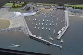
A new steering group has been established to work with consultants, councillors and stakeholders to progress the Bray Harbour improvement project.

As reported last month on Afloat.ie, more than €7.1 million from the Urban Regeneration and Development Fund has been awarded to the Co Wicklow town for harbour rejuvenation works.

On the water, works will include dredging of the harbour allowing for the mooring of larger vessels, with a review of potential for extending the harbour wall to give better protection from waves in stormy conditions.

On land, there are plans for improving street lighting and paving, better provision for motorists and cyclists alike, improved sporting facilities and a new promenade boardwalk linking Bray's renowned promenade with the harbour. It's also proposed to relocate boat storage to the north of the harbour.

Wicklow County Council says it will keep all stakeholders up to date with any new information on its plans for the harbour.

Published in Irish Harbours
Tagged under

Bray can once again become a proud harbour town with the €7.1m of Urban Regional Development Funding for the rejuvenation of Bray Harbour and the surrounding area. of Urban Regional Development Funding for the rejuvenation of Bray Harbour and the surrounding area.

The proposed facilities for ferry docking and the river deepening will open up tourism and marine leisure commercial activities.

Bray Harbour's Joint Development Committee has welcomed today's announcement by Ministers Darragh O'Brien and Stephen Donnelly.

Welcoming the announcement, committee chairman J J O'Dwyer said: "This funding will benefit not only harbour users, but it will provide significantly enhanced amenities to all the people of Bray".

This project focuses on the regeneration of the Bray Harbour Area and releasing various sites for future development through a series of integrated elements.

The overall vision is to re-imagine and regenerate the strategically located waterfront area of Bray; to increase economic activity, amenity, and connectivity to public transport, the sea-front and esplanade. The aim is to deliver a vibrant public amenity that will be of great benefit to residents and visitors alike. Works envisaged include:

  • Amenity and Public Realm – an extension of amenity areas, improvement of the streetscape, parking, cycle provision and sporting facilities
  • Promenade Board Walk - linking the promenade with the harbour
  • Cycle Bridge - to relieve a pinch point at the Dargle Bridge crossing
  • Relocation of boat storage to the north of the harbour
Published in Irish Harbours
Tagged under

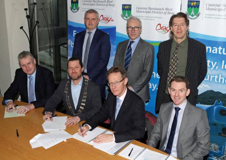
Wicklow County Council last week (Wednesday 29 January) signed a contract for a study of Bray Harbour with consultants RPS Group.

The project requires the consultants to carry out detailed surveys, and report on the options available to protect the harbour from storm conditions.

They are also charged with looking into options to provide additional berthing facilities, including the possibility of providing a short-term drop on/drop off berth for a small passenger vessel plying between different harbours within an hour or so of Bray.

The funding for this exploratory work was approved by members of Bray Municipal District Council in 2018. That plan involves restoration of the south harbour wall to its pre-1957 state, before the collapse of the pier end and lighthouse, as well as providing a deep water channel.

Bray MD Cathaoirleach Steven Matthews said: “I am delighted that we have now engaged RPS Group to develop detailed plans for our harbour.

“Bray Harbour is an amenity that most seaside towns would be extremely envious of and is in urgent need of improvement and development so that we can maximise the potential of this resource for everyone in our community.

“I would like to thank the council officials who have worked so hard to get this far and look forward to seeing this project move on to the next stage.”
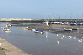
Published in Irish Harbours
Tagged under

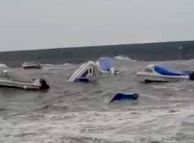
The northerly gales that brought damage to east coast harbours yesterday including Dun Laoghaire on Dublin Bay, also caused damage in County Wicklow at Bray Harbour.

According to local reports, up to eight boats were wrecked in the high seas yesterday afternoon as this reader video (below) illustrates.

There are now 'serious concerns' that more bad weather is on the way this week as Hurricane Lorenzo could hit Ireland on Thursday.

All local authorities have been instructed to activate crisis management.

Published in News Update
Tagged under

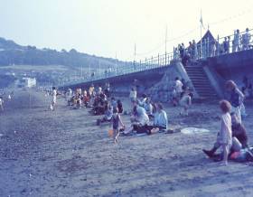
An illustrated talk on the Maritime History of Bray in County Wicklow will take place in the Royal Hotel Bray on Thursday 21/02/2019 at 8pm by Brian White historian/author.

The talk will trace the history of the five harbours of Bray. Stories of smugglers and development of the esplanade and the grand marine promenade and the three Martello Towers.

How a church spire in the town played an important role in calculating pilotage fees for Dublin Port.

The role of the Coastguard Station in Bray and various maritime clubs and societies including Bray Sailing Club, Bray Rowing Club, Bray Swimming Club, Fishermen and Anglers of Bray and Sea Scouting.

In 1957 the lighthouse at Bray Harbour was washed into the sea, prompting the saying “ Bray was the only place in the world with a lighthouse for submarines”.

Published in Coastal Notes
Tagged under

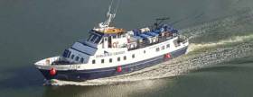
On Friday 6th July at 7 pm some local maritime history will be made in Bray Harbour when the St. Bridget will make its inaugural visit to Bray with 100 passengers on board. The St. Bridget will dock at the South pier inside Bray Harbour. 

Announcing the arrival of St. Bridget in Bray, Wicklow County Council Cathaoirleach  Pat Vance said “This underscores the importance and potential of the harbour for Bray. It also affirms the decision of Bray Municipal District to provide funding for the rejuvenation of Bray Harbour on foot of a proposal made by The Bray Harbour Joint Development Committee.

The project involves providing protection of the harbour from the East/Northeast by restoring the south harbour wall to approximately where it was before the collapse of the pier end and Lighthouse in 1957. This will enable the development of facilities that will make the visit of similar vessels a regular occurrence”.

The St. Bridget is known to many for her well-known and highly regarded cruises in Dublin Bay. She is one of five passenger ships owned and operated by Eugene Garrihy, who said “we are delighted to be the first to bring a passenger ship to Bray and hope that this may prove to be the first of many such visits”.

Published in Ferry
Tagged under

Bray Municipal District has agreed a plan and to provide funding for the rejuvenation of Bray Harbour on foot of a proposal made by The Bray Harbour Joint Development Committee.

The proposal involves providing protection of the harbour from East/Northeast by restoring the south harbour wall to approximately where it was before the collapse of the pier end and Lighthouse in 1957, training and deepening the river to provide a deep water channel navigable at all stages of the tide and restoring the overall depth of the harbour to 3 hours either side of HW

This will enable the provision of a deep water berth for visiting coastal cruise ships carrying up to 200 passengers, deep water pontoons in the river channel for local harbour users, visitors and marine leisure commercial providers. It will also provide for an increased number of safe revenue generating moorings.

The provision of pontoons will mean that local people and visitors wishing to take to the water will now have easy inexpensive access to marine leisure activities at all stages of the tide.

This development , especially the pontoons, will give impetus to significant opportunities in the growing marine leisure commercial activity generating both increased spend and job numbers in the local economy.

For existing harbour users it will mean safe moorings navigable for longer and the possibility of being able to use boats all year.

There are very significant economic benefits to the local economy in terms of visitor spend, direct earnings from visitor mooring fees and increase in number of moorings available for letting. 

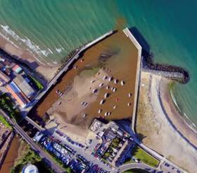
The proposal also envisages the creation of an urban space in the southwestern corner of the harbour. This has the benefit of not only creating additional amenity for local people and visitors but also provides a cost effective environmentally friendly means of dealing with the surplus sand to be removed from the harbour floor.

The Bray Harbour Joint Development Committee is made up of members of the Bray Harbour Action Group (representing harbour users) and four representatives from Wicklow County Council. 

The likely cost of the project is estimated at circa €1million

This development will not only transform the harbour area but it also has the potential to make Bray an attractive Harbour Town providing additional amenities for local people and attracting visitors by land and sea.

Published in Coastal Notes
Tagged under

Bray Harbour Action Group (BHAG), at its meeting on Tuesday 21st Feb, welcomed the report by District Manager Des O Brien to the Bray Municipal District meeting on 7th February as reported in the Bray People of 18th February here.

As Afloat.ie reported previously the action group was set up last November to deal with a situation in the east coast harbour that feared would leave a 'real prospect of the harbour becoming an abandoned eyesore'.

“This is a welcome development, said Ger Crowley BHAG chairman, it indicates a commitment by the Council to remedy this threat to the ongoing viability of the harbour. It is reassuring to hear that the sand in the harbour is not contaminated. The favoured approach, therefore, of using it for beach nourishment looks like a win-win solution benefiting both the harbour and the beach”.

“However, he continued, we are deeply concerned re the possibility of delay as the build-up of sand is a ticking time-bomb which if not addressed could well leave the harbour as a permanent derelict eyesore”

Ger went on to say that “the amount of public goodwill towards improving the harbour is terrific and we have been really delighted by the positive public response to BHAG. 

Ger also said that “BHAG are really looking forward to taking up the invitation to meet with Bray Municipal Council on April 4th. At the meeting we plan not only to set out our concerns re the harbour but also our vision for a harbour that will benefit all the people of Bray”

Published in Coastal Notes
Tagged under

Clubs and users of Bray Harbour met again last Tuesday night at Bray Head Fishing and Social Club to form the Bray Harbour Action Group to deal with the build up of sand silting up the harbour.

Newly appointed chair of the Bray Harbour Action Group Ger Crowley said “We are at a cross-roads, failure to address the issues affecting the harbour now and in particular the build-up of sand and silt will lead to the real prospect of the harbour becoming an abandoned eyesore. On the other hand if we act now and look to the future we can look forward to a harbour that is a vibrant centre for water based leisure and commercial activity and a magnificent amenity for the people of Bray and beyond.”

Ger continued “We want to work in cooperation and in unison with all stakeholders to achieve a better outcome for all. We have a big programme of work to undertake and we are getting started immediately. We will shortly be seeking a meeting with Public Representatives and Council Officials to outline our serious concerns and explain our objectives”.
Ger is a well- known Bray man, a long time daily user of the harbour in his skiff, round Ireland rower and community activist.

Bray Harbour Action Group has adopted the following objectives:

1. To seek to address the issues, including the build –up of sand and silt, that are causing a real and immediate threat to the future viability of Bray harbour as a centre for water-based leisure and commercial activity.

2. To pursue the achievement of the potential of Bray Harbour as a location of choice for water –based leisure and commercial activity and as a magnificent amenity for all the people of Bray and beyond

Bray Harbour Action Group plans to pursue these objectives by

• Building public awareness re the threats to the harbour and also its potential

• Lobbying for action and support

• Developing and promoting proposals for addressing the threats and for achieving the harbour’s true potential

• Working in cooperation and in unison with other stakeholders

Published in Coastal Notes
Tagged under

#BrayHarbour - Boat owners in Bray are urged to be vigilant after a number of engines were stolen from boats in the harbour last month.

The Wicklow Times reports that a number of boats moored in the harbour were apparently targeted by thieves who struck in the early hours of Monday 22 August.

A number of engines were taken in the brazen raid, as well as radio and GPS equipment.

"We know it happened at low tide when they would have had easy access," said Bray Sailing Club Commodore Mark Henderson.

"Unfortunately all our CCTV could pick up was flashlights as we know the robberies took place between 2 and 3am ... but it was too dark to make out faces."

Anyone in the market for a secondhand engine has been asked to check where it came from, and report any suspicions to the relevant authorities.

Published in News Update
Tagged under
Page 1 of 2

General Information on using Waterways Ireland inland navigations

Safety on the Water

All users of the navigations are strongly recommended to make themselves aware of safety on the water for whatever activity they are involved in and to read the advice offered by the various governing bodies and by:

The Dept. of Transport, Ireland: www.gov.ie/transport and The Maritime and Coastguard Agency, UK, The RNLI – Water Safety Ireland for information in terms of drowning prevention and water safety.

Registration of Vessels

All vessels using the Shannon Navigation, which includes the Shannon-Erne Waterways and the Erne System must be registered with Waterways Ireland. Only open undecked boats with an engine of 15 horsepower or less on the Shannon Navigation, and vessels of 10 horsepower or less on the Erne System, are exempt. Registration is free of charge.

Craft registration should be completed online at: https://www.waterwaysireland.org/online-services/craft-registration

Permits for use of the Grand and Royal Canals and the Barrow Navigation

All vessels using the Grand and Royal Canals and the Barrow Navigation must display appropriate valid Permit(s) i.e A Combined Mooring and Passage Permit (€126) and if not intending to move every five days, an Extended Mooring Permit (€152).

Permit applications should be completed online at: https://www.waterwaysireland.org/online-services/canal-permits

Passage on the Royal and Grand Canals – Dublin Area

For boat passage through the locks east of Lock 12 into / out of Dublin on either the Royal or Grand Canals, Masters are requested to contact the Waterways Ireland Eastern Regional Office (M-F 9.30am-4.30pm) on tel: +353(0)1 868 0148 or email [email protected] prior to making passage in order to plan the necessary lock-keeping assistance arrangements.

On the Grand Canal a minimum of two days notice prior to the planned passage should be given, masters should note that with the exception of pre-arranged events, a maximum of 2 boats per day will be taken through the locks, travelling either east or west.

Movements in or out of the city will be organised by prior arrangement to take place as a single movement in one day. Boaters will be facilitated to travel the system if their passage is considered to be safe by Waterways Ireland and they have the valid permit(s) for mooring and passage.

Newcomen Lifting Bridge

On the Royal Canal two weeks’ notice of bridge passage (Newcomen Lifting Bridge) is required for the pre-set lift date, and lock assistance will then also be arranged. A minimum of 2 boats is required for a bridge lift to go ahead.

Waterways Ireland Eastern Regional Office (Tel: +353(0)1 868 0148 or [email protected] ) is the point of contact for the bridge lift.

A maximum number of boats passing will be implemented to keep to the times given above for the planned lifts (16 for the Sat / Sun lifts & 8 for the weekday lifts). Priority will be given on a first come first served basis.

On day of lift, boaters and passengers must follow guidance from Waterways Ireland staff about sequence of passage under bridge & through Lock 1, and must remain within signed and designated areas.

Events Held on the Waterways

All organised events taking place on the waterways must have the prior approval of Waterways Ireland. This is a twelve week process and application forms must be accompanied with the appropriate insurance, signed indemnity and risk assessment. The application should be completed on the Waterways Ireland events page at :

https://www.waterwaysireland.org/online-services/event-approval

Time Limits on Mooring in Public Harbours

On the Shannon Navigation and the Shannon-Erne Waterway craft may berth in public harbours for five consecutive days or a total of seven days in any one month.

On the Erne System, revised Bye Laws state that: No master or owner shall permit a vessel, boat or any floating or sunken object to remain moored at or in the vicinity of any public mooring, including mooring at any other public mooring within 3 kilometres of that location, for more than 3 consecutive days and shall not moor at that same mooring or any other public mooring within 3 kilometres of that location within the following 3 consecutive days without prior permission by an authorised official.

Winter Mooring on the Shannon Navigation and Shannon Erne Waterway

Winter mooring may be availed of by owners during the period 1 Nov to 31 Mar by prior arrangement and payment of a charge of €63.50 per craft. Craft not availing of Winter Mooring must continue to comply with the “5 Day Rule”. Winter Mooring applications should be completed online at : https://www.waterwaysireland.org/online-services/winter-moorings-booking

Owners should be aware that electricity supply and water supply to public moorings is disconnected for the winter months. This is to protect against frost damage, to reduce running costs and to minimise maintenance requirements during the winter months.

Vessel owners are advised that advance purchasing of electricity on the power bollards leading up to the disconnection date should be minimal. Electricity credit existing on the bollards will not be recoverable after the winter decommissioning date. Both services will be reinstated prior to the commencement of the next boating season.

Smart Cards

Waterways Ireland smart cards are used to operate locks on the Shannon Erne Waterway, to access the service blocks, to use the pump-outs along the navigations, to avail of electrical power at Waterways Ireland jetties.

Berthing in Public Harbours

Masters are reminded of the following:

  • Equip their vessel with mooring lines of appropriate length and strength and only secure their craft to mooring bollards and cleats provided for this purpose.
  • Ensure the available berth is suitable to the length of your vessel, do not overhang the mooring especially on finger moorings on floating pontoon moorings.
  • Ensure mooring lines, electric cables and fresh water hoses do not create a trip hazard on public jetties for others users.
  • Carry sufficient fenders to prevent damage to your own vessel, other vessels and WI property.
  • Allow sufficient space between your vessel and the vessel ahead /astern (c.1m) for fire safety purposes and /or to recover somebody from the water.
  • Do not berth more than two vessels side by side and ensure there is safe access/egress at all times between vessels and onto the harbour itself.
  • Do not berth in such a way to prevent use of harbour safety ladders, slipways or pump-outs.
  • Do not allow the bow of your vessel to overhang the walkway of a floating mooring thus creating a hazard for others with an overhanging anchor or bow fendering.
  • Animals are not allowed to be loose or stray at any time.
  • Harbour and jetty infrastructure such as railings, power pedestals, fresh water taps, electric light poles, safety bollards, ladders etc are not designed for the purpose of mooring craft , they will not bear the strain of a vessel and will be damaged.
  • At Carrybridge on the Erne System, Masters of vessels are not permitted to use stern on mooring. Masters of vessels must use the mooring fingers for mooring of vessels and for embarkation / disembarkation from vessels.

Passenger Vessel Berths

Masters of vessels should not berth on passenger vessel berths where it is indicated that an arrival is imminent. Passenger vessels plying the navigations generally only occupy the berths to embark and disembark passengers and rarely remain on the berths for extended periods or overnight.

Lock Lead-in Jetties

Lead-in jetties adjacent to the upstream and downstream gates at lock chambers are solely for the purpose of craft waiting to use the lock and should not be used for long term berthing.

Vessel Wake

Vessel wake, that is, the wave generated by the passage of the boat through the water, can sometimes be large, powerful and destructive depending on the hull shape and engine power of the vessel. This wake can be detrimental to other users of the navigation when it strikes their craft or inundates the shoreline or riverbank. Masters are requested to frequently look behind and check the effect of their wake / wash particularly when passing moored vessels, on entering harbours and approaching jetties and to be aware of people pursuing other activities such as fishing on the riverbank.

Speed Restriction

A vessel or boat shall not be navigated on the Shannon Navigation at a speed in excess of 5 kph when within 200 metres of a bridge, quay, jetty or wharf, when in a harbour or canal or when passing within 100 metres of a moored vessel or boat.

Vessels navigating the Shannon-Erne Waterway should observe the general 5 kph speed limit which applies along the waterway. This is necessary in order to prevent damage to the banks caused by excessive wash from vessels.

Vessels navigating the Erne System should observe the statutory 5kt / 6mph / 10kph speed limit areas.

A craft on the Royal and Grand canals shall not be navigated at a speed in excess of 6km per hour.

A craft on the Barrow Navigation shall not be navigated at a speed in excess of 11km per hour except as necessary for safe navigation in conditions of fast flow.

Bank Erosion

Narrow sections of all the navigations are particularly prone to bank erosion due to the large wash generated by some craft. Masters are requested to be vigilant and to slow down to a speed sufficient to maintain steerage when they observe the wash of their craft inundating the river banks.

Unusual Waterborne Activity

Unusual waterborne vessels may be encountered from time to time, such as, hovercraft or amphibious aircraft / seaplanes. Masters of such craft are reminded to apply the normal “Rule of the Road” when they meet conventional craft on the water and to allow extra room to manoeuvre in the interest of safety.

Sailing Activity

Mariners will encounter large numbers of sailing dinghies from late June to August in the vicinity of Lough Derg, Lough Ree and Lower Lough Erne. Sailing courses are marked by yellow buoys to suit weather conditions on the day. Vessels should proceed at slow speed and with due caution and observe the rules of navigation when passing these fleets, as many of the participants are junior sailors under training.

Rowing

Mariners should expect to meet canoes and vessels under oars on any part of the navigations, but more so in the vicinity of Athlone, Carrick-on-Shannon, Coleraine, Enniskillen and Limerick. Masters are reminded to proceed at slow speed and especially to reduce their wash to a minimum when passing these craft as they can be easily upset and swamped due to their very low freeboard and always be prepared to give way in any given traffic situation.

Canoeing

Canoeing is an adventure sport and participants are strongly recommended to seek the advice of the sport’s governing bodies i.e Canoeing Ireland and the Canoe Association of Northern Ireland, before venturing onto the navigations.

Persons in charge of canoes are reminded of the inherent danger to these craft associated with operating close to weirs, sluice gates, locks and other infrastructure particularly when rivers are in flood and large volumes of water are moving through the navigations due to general flood conditions or very heavy localised precipitation e.g. turbulent and broken water, stopper waves. Shooting weirs is prohibited without prior permission of Waterways Ireland.

Canoeists should check with lockkeepers prior entering a lock to ensure passage is done in a safe manner. Portage is required at all unmanned locks.

Canoe Trail Network – "Blueways"

Masters of powered craft are reminded that a canoe trail network is being developed across all navigations and to expect more organised canoeing along these trails necessitating slow speed and minimum wash when encountering canoeists, rowing boats etc

Rockingham and Drummans Island Canals – Lough Key

It is expected that work on Rockingham and Drummans Island Canals on Lough Key will be completed in 2021. Access to these canals will be for non-powered craft only, eg canoes, kayaks, rowing boats.

Fast Powerboats and Personal Watercraft (Jet Skis)

Masters of Fast Powerboats (speed greater than 17kts) and Personal Watercraft (i.e.Jet Skis) are reminded of the inherent dangers associated with high speed on the water and especially in the confines of small bays and narrow sections of the navigations. Keeping a proper look-out, making early alterations to course and /or reducing speed will avoid conflict with slower vessels using the navigation. Personal Watercraft are not permitted to be used on the canals.

Towing Waterskiers, Wakeboarders, Doughnuts etc

Masters of vessels engaged in any of these activities are reminded of the manoeuvring constraints imposed upon their vessel by the tow and of the added responsibilities that they have to the person(s) being towed. These activities should be conducted in areas which are clear of conflicting traffic. It is highly recommended that a person additional to the master be carried to act as a “look-out” to keep the tow under observation at all times.

Prohibition on Swimming

Swimming in the navigable channel, particularly at bridges, is dangerous and is prohibited due to the risk of being run over by a vessel underway in the navigation.

Age Restrictions on operating of powered craft

In the Republic of Ireland, Statutory Instrument 921 of 2005 provides the legal requirements regarding the minimum age for operating of powered craft. The Statutory Instrument contains the following requirements:

- The master or owner of a personal watercraft or a fast power craft shall take all reasonable steps to ensure that a person who has not attained the age of 16 years does not operate or control the craft

- The master or owner of a pleasure craft powered by an engine with a rating of more than 5 horse power or 3.7 kilowatts shall take all reasonable steps to ensure that a person who has not attained the age of 12 years does not operate or control the craft.

Lifejackets and Personal Flotation Devices (PFDs)

Lifejackets and PFD’s are the single most important items of personal protective equipment to be used on a vessel and should be worn especially when the vessel is being manoeuvred such as entering / departing a lock, anchoring, coming alongside or departing a jetty or quayside.

In the Republic of Ireland, Statutory Instrument 921 of 2005 provides the legal requirements regarding the wearing of Personal Flotation Devices. The Statutory Instrument contains the following requirements:

- The master or owner of a pleasure craft (other than a personal watercraft) shall ensure, that there are, at all times on board the craft, sufficient suitable personal flotation devices for each person on board.

- A person on a pleasure craft (other than a personal watercraft) of less than 7 metres length overall shall wear a suitable personal flotation device while on board an open craft or while on the deck of decked craft, other than when the craft is made fast to the shore or at anchor.

- The master or owner of a pleasure craft (other than a personal watercraft) shall take all reasonable steps to ensure that a person who has not attained the age of 16 years complies with paragraph above.

- The master or owner of a pleasure craft (other than a personal watercraft), shall take all reasonable steps to ensure that a person who has not attained the age of 16 years wears a suitable personal flotation device while on board an open craft or while on the deck of a decked craft other than when it is made fast to the shore or at anchor.

- The master or owner of a pleasure craft (other than a personal watercraft) shall take all reasonable steps to ensure that a person wears a suitable personal flotation device, at all times while – (a) being towed by the craft, (b) on board a vessel or object of any kind which is being towed by the craft.

Further information is available at: http://www.irishstatutebook.ie/eli/2005/si/921/made/en/print

Firing Range Danger Area – Lough Ree

The attention of mariners is drawn to the Irish Defence Forces Firing Range situated in the vicinity of buoys No’s 2 and 3, on Lough Ree on the Shannon Navigation. This range is used regularly for live firing exercises, throughout the year, all boats and vessels should stay clear of the area marked with yellow buoys showing a yellow "X" topmark and displaying the word "Danger".

Shannon Navigation, Portumna Swing Bridge Tolls

No attempt should be made by Masters’ of vessels to pay the bridge toll while making way through the bridge opening. Payment will only be taken by the Collector from Masters when they are secured alongside the jetties north and south of the bridge.

Navigating from Killaloe to Limerick on the Shannon Navigation

The navigation from Killaloe to Limerick involves passage through Ardnacrusha locks, the associated headrace and tailrace and the Abbey River into Limerick City. Careful passage planning is required to undertake this voyage. Considerations include: lock passage at Ardnacrusha, water flow in the navigation, airdraft under bridges on Abbey River in Limerick, state of tide in Limerick

Users are advised to contact the ESB Ardnacrusha hydroelectric power station (00353 (0)87 9970131) 48 hours in advance of commencing their journey to book passage through the locks at Ardnacrusha. It is NOT advised to undertake a voyage if more than one turbine is operating (20MW), due to the increased velocity of flow in the navigation channel, which can be dangerous. To ascertain automatically in real time how many turbines are running, users can phone +353 (0)87 6477229.

For safety reasons the ESB has advised that only powered craft with a capacity in excess of 5 knots are allowed to enter Ardnacrusha Headrace and Tailrace Canals.

Passage through Sarsfield Lock should be booked on +353-87-7972998, on the day prior to travel and it should be noted also that transit is not possible two hours either side of low water.

A Hydrographic survey in 2020 of the navigation channel revealed that the approach from Shannon Bridge to Sarsfield Lock and the Dock area has silted up. Masters of vessels and water users are advised to navigate to the Lock from Shannon bridge on a rising tide one or two hours before High Tide.

Lower Bann Navigation

The attention of all users is drawn to the “Users Code for the Lower Bann”, in particular to that section covering “Flow in the River” outlining the dangers for users both on the banks and in the navigation, associated with high flow rates when the river is in spate. Canoeists should consult and carry a copy of the “Lower Bann Canoe Trail” guide issued by the Canoe Association of Northern Ireland. Users should also contact the DfI Rivers Coleraine, who is responsible for regulating the flow rates on the river, for advisory information on the flow rates to be expected on any given day.

DfI Rivers Coleraine. Tel: 0044 28 7034 2357 Email: [email protected]

Lower Bann Navigation – Newferry – No wake zone

A No Wake Zone exists on the Lower Bann Navigation at Newferry. Masters of vessels are requested to proceed at a slow speed and create no wake while passing the jetties and slipways at Newferry.

Overhead Power Lines (OHPL) and Air draft

All Masters must be aware of the dangers associated with overhead power lines, in particular sailing vessels and workboats with cranes or large air drafts. Voyage planning is a necessity in order to identify the location of overhead lines crossing the navigation.

Overhead power line heights on the River Shannon are maintained at 12.6metres (40 feet) from Normal Summer level for that section of navigation, masters of vessels with a large air draft should proceed with caution and make additional allowances when water levels are high.

If a vessel or its equipment comes into contact with an OHPL the operator should NOT attempt to move the vessel or equipment. The conductor may still be alive or re-energise automatically. Maintain a safe distance and prevent third parties from approaching due to risk of arcing. Contact the emergency services for assistance.

Anglers are also reminded that a minimum ground distance of 30 metres should be maintained from overhead power lines when using a rod and line.

Submarine Cables and Pipes

Masters of vessels are reminded not to anchor their vessels in the vicinity of submarine cables or pipes in case they foul their anchor or damage the cables or pipes. Look to the river banks for signage indicating their presence.

Water Levels - Precautions

Low Water Levels:

When water levels fall below normal summer levels masters should be aware of:

Navigation

To reduce the risk of grounding masters should navigate on or near the centreline of the channel, avoid short cutting in dog-legged channels and navigating too close to navigation markers.

Proceeding at a slow speed will also reduce “squat” effect i.e. where the vessel tends to sit lower in the water as a consequence of higher speed.

Slipways

Reduced slipway length available under the water surface and the possibility of launching trailers dropping off the end of the concrete apron.

More slipway surface susceptible to weed growth requiring care while engaged in launching boats, from slipping and sliding on the slope. Note also that launching vehicles may not be able to get sufficient traction on the slipway once the craft is launched to get up the incline.

Bank Erosion

Very dry riverbanks are more susceptible to erosion from vessel wash.

Lock Share

Maximising on the number of vessels in a lock will ensure that the total volume of water moving downstream is decreased. Lock cycles should be used for vessels travelling each way.

High Water Levels:

When water levels rise above normal summer level masters should be aware of:

Navigation

Navigation marks will have reduced height above the water level or may disappear underwater altogether making the navigable channel difficult to discern.

In narrow sections of the navigations water levels will tend to rise more quickly than in main streams and air draft at bridges will likewise be reduced.

There will also be increased flow rates particularly in the vicinity of navigation infrastructure such as bridges, weirs, locks etc where extra care in manoeuvring vessels will be required.

Harbours and Jetties

Due care is required in harbours and at slipways when levels are at or near the same level as the harbour walkways' as the edge will be difficult to discern especially in reduced light conditions. It is advised that Personal Flotation Devices be worn if tending to craft in a harbour in these conditions.

Slipways

Slipways should only be used for the purpose of launching and recovering of water craft or other objects from the water. Before using a slipway it should be examined to ensure that the surface has sufficient traction/grip for the intended purpose such as launching a craft from a trailer using a vehicle, that there is sufficient depth of water on the slipway to float the craft off the trailer before the concrete apron ends and that the wheels of the trailer do not drop off the edge of the slipway. That life-saving appliances are available in the vicinity, that the vehicle is roadworthy and capable of coping with the weight of the trailer and boat on the incline. It is recommended that slipway operations are conducted by two persons.

Caution to be Used in Reliance upon Aids to Navigation

The aids to navigation depicted on the navigation guides comprise a system of fixed and floating aids to navigation. Prudent mariners will not rely solely on any single aid to navigation, particularly a floating aid to navigation. With respect to buoys, the buoy symbol is used to indicate the approximate position of the buoy body and the ground tackle which secures it to the lake or river bed. The approximate position is used because of the practical limitations in positioning and maintaining buoys in precise geographical locations. These limitations include, but are not limited to, prevailing atmospheric and lake/river conditions, the slope of and the material making up the lake/river bed, the fact that the buoys are moored to varying lengths of chain, and the fact that the buoy body and/or ground tackle positions are not under continuous surveillance. Due to the forces of nature, the position of the buoy body can be expected to shift inside and outside the charted symbol.

Buoys and perches are also moved out of position or pulled over by those mariners who use them to moor up to instead of anchoring. To this end, mariners should always monitor their passage by relating buoy/perch positions with the published navigation guide. Furthermore, a vessel attempting to pass close by always risks collision with a yawing buoy or with the obstruction that the buoy or beacon/perch marks.

Masters of Vessels are requested to use the most up to date Navigation guides when navigating on the Inland Waterways.

Information taken from Special Marine Notice No 1 of 2023