Menu

Ireland's sailing, boating & maritime magazine

Inland afloat headers


Displaying items by tag: Coastal Notes
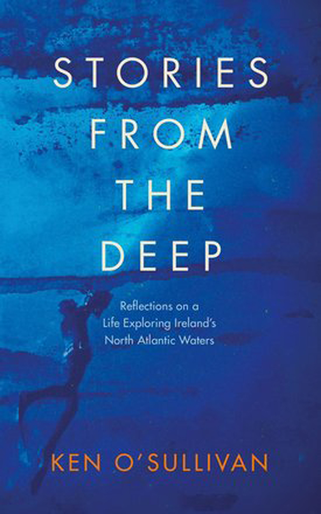
Ken O’Sullivan spent the summers of his youth in what he describes as a ‘Huckleberry Finn-type existence’ on Fenit Island, Co Kerry, his father’s home place and that of his family since 1750. Getting the fishing bug at aged 10, his days were passed pulling nets out of freezing pre-dawn waters, and picking periwinkles and carrageen he’d sell in Tralee. Hard work, but it brought a great sense of purpose, of harvest and subsistence and self-dependence.

Little did he know, these were experiences and lessons that would stand to him when he chose a difficult but rewarding career route as a film-maker producing documentaries about the sea. This resulted in three ocean wildlife TV series including the critically acclaimed RTÉ TV series, ‘Ireland’s Deep Atlantic’, broadcast in 2018 and now a part to the Junior Cert curriculum.

Stories from the Deep is Ken’s lyrical potted memoir of a life-sustaining connection with the sea. Emigrating from recession Ireland to New York in the 1980s, O’Sullivan drove a truck, moved furniture and swept streets whilst trying to ‘make it’ in a rock band, before moving to London to work in computing on financial trading floors – but every sweltering summer Sunday was always spent craving for the sea at Lahinch, near his home place in Clare.

final cover 2Sea Fever - the new book by Ken O'Sullivan

Surrounded by pin-striped suits, money and egos, he felt suffocated, longing for the wide-open spaces of home, but he persevered, believing doing something you loved for a living wasn’t realistic. Until one-day his heart suddenly over-ruled his head. He just couldn’t work anymore and packed it in. So began his journey back home to Ireland and the sea.

Making peace with his home-place, he swam every day and explored the undersea world around Ireland, discovering breathtakingly beautiful habitats and creatures. Teaching himself underwater photography, Ken dedicated himself to making documentaries about the sea and ocean conservation, he was reminded of the summers of his youth spent fishing, and of his ancestors who made a living that way before him - for life as a film-maker was often one of subsistence and self-dependence, but it was also one of great meaning and adventure, all of which is documented in Ken’s new book, Stories from the Deep.

From childhood summers spent on Fenit Island, to the years in New York and London longing for the ocean, and stories of chasing giant whales, waves and running from storms off Ireland’s west coast and around the world, Stories from the Deep is a captivating memoir that eloquently encapsulates a magical connection with the sea.

The book is available directly from Afloat here at €16.99 plus P&P

Published in Book Review

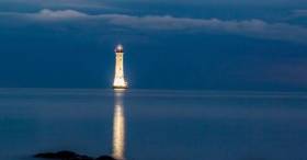
Near the border of Northern Ireland and the Republic sits a famous lighthouse which has been illuminated in memory of people who have died in Carlingford Lough.

The Haulbowline Lighthouse, writes the Irish Examiner, is situated on the Lough, separating Co Louth and Co Down, and is thought to be the first and only lighthouse in Ireland and the UK to be externally illuminated.

The 34-metre tall lighthouse will remain lit up for the month of August to remember all those who have lost their lives there.

Carlingford Lough experienced its worst maritime disaster in 1916 when a coalship  collided with a passenger ferry bound for Holyhead out of Greenore.

The disaster claimed the lives of 97 people, including passengers and crew. Only one person, a fireman on the collier, survived.

Click here for more on this story. 

Published in Lighthouses

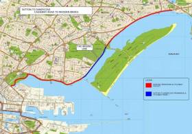
#S2S - The latest section of the Sutton to Sandycove (S2S) cycle route around Dublin Bay will not be opened till March due to delays on water main works, as Irish Cycle reports.

Once completed, the new cycle track — with mixed pedestrian and cyclist sections at junctions — will connect the pre-existing tracks between Sutton and the Bull Island causeway, and the route from Bull Bridge to East Wall Road.

As yet no section of the southside portion of the S2S has been completed, though a public consultation on the corridor from Sandymount/Merrion to Blackrock is currently open for public consultation till 31 January.

Irish Cycle has more on the story HERE.

Published in Dublin Bay

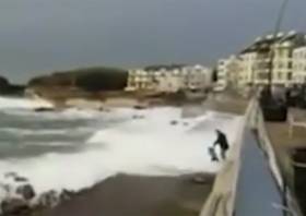
#WaterSafety - The Irish Coast Guard has once again warned the public to stay back and say safe in coastal areas during severe weather after video emerged of a young child swept off their feet by a surprise wave.

Independet.ie has video of the recent incident in Portstewart on the North Coast, where a man and the child are filmed walking along the promenade as large waves lap over the edge at high tide.

Published in Water Safety

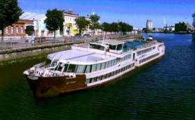
#CorkFloatel -The first floating hotel and restaurant in Ireland writes the Evening Echo is being planned for Cork's city centre quays.

The backers of the project have secured a 100-metre luxury cruise vessel that they plan to permanently moor at Penrose Quay near the Custom House and operate as a four-star hotel.

The €1.75m ship ‘My Story’ is 105 metres long and has 87 cabins, three decks, lounge areas, a large restaurant and sun deck. It previously operated on the River Rhine.

The floating vessel would be moored adjacent to Michael Collins Bridge, and modifications will also be made to the quay wall to provide gangway access.

The backers of the project Sick & Sore Limited said the vessel would enhance the leisure amenities of Cork. Based in Dublin, the company is headed by Sam Corbett, who has been involved in many maritime projects around Ireland.

He was a key part of the project to acquire the former Cork-based tender vessel the Cill Áirne, renovating and refitting it for use as a restaurant on Dublin’s North Wall Quay.

Mr Corbett told the Evening Echo the project has the backing of a major tourism and accommodation operator.

For more on this development, click here. 

Published in Cork Harbour

#CoastalNotes - Coastal defences and protections against flooding are outlined in a new Department of Transport plan to prepare Ireland for future climate change, as The Irish Times reports.

The draft consultation report, Developing Resilience to Climate Change in the Irish Transport Sector, details measures such as coastal flood defences at Shannon Airport and the railway line at Rosslare Harbour, the latter of which is inching ever closer to the cliff on the eroding shoreline.

As previously reported on Afloat.ie, the East Coast line suffered significant damage north of Wicklow town during last month’s Storm Angus.

Predicted rises in temperatures and sea level over the next century are expected to bring more of such storms, with heavier rainfalls and an increased risk of flooding and landslides in prone areas.

All of this has prompted the new plan to identify key remedial works for future-proofing the country’s transport infrastructure.

The Irish Times has more on the story HERE.

Published in Coastal Notes

#BullochHarbour – Plans to redevelop the former Western Marine site at Bulloch Harbour, Dalkey in south Dublin, with a mixed development of houses, a café and shops are centre stage to a mounting campaign led by local opponents, writes Jehan Ashmore.

Developer Bartra Property Ltd lodged a planning permission with Dun Laoghaire-Rathdown County Council as Afloat reported early this month but further details can be revealed with the depicted image above of the proposed three-storey structure. If granted planning permission this would involve demolition of the existing single-storey warehouse previously used by Western Marine.

The marine business that was based in Dalkey for almost half a century are to relocate to new premises elsewhere but locally within the borough.

The proposed structure at Bulloch Harbour is a mixed use block of two and three stories high containing seven marine based units at ground floor level along the quayside. In addition to six residential units at ground floor to the rear and first and second floor overhead.

According to the Save Bulloch Harbour campaign they have raised concerns on the impact of such a development on the character of the scenic south Dublin Bay harbour. Overlooking the harbour is Bulloch Castle dating to the 12th century having been founded by the Cistercian Monks who held lucrative fishing rights. 

A public meeting organised by Save Bulloch Harbour is to held on Thursday 5th January 2017.

The campaign is been led by the newly formed Bulloch Harbour Preservation Association, a group of boat owners, fishermen and harbour users. They claim that the harbour is one of the last small working harbours in county Dublin and the only place to keep or rent a small boat in the south of the county. The stone-cut harbour is notably popular in the summer with locals and tourists availing of marine leisure amenities.

The development in the planning application to DLRCC is described as a mixed-use marine commercial, leisure/community and residential based development, to consult click here.

According to Save Our Seafront (SOS) campaign of Dun Laoghaire Harbour, they claim the Bulloch Harbour development containing the three-storey houses are each about 5,000 square feet.

Published in Dublin Bay

#Weather - Met Éireann has announced a Status Yellow small craft warning for strong gales in effect today (Wednesday 21 December) ahead of Storm Barbara’s expected arrival at the weekend.

Southwest winds will reach Force 8 at times this evening and tonight on coasts from Slyne Head to Rossan Point to Fair Head.

That’s before the deep Atlantic depression, the second winter storm of the current season, tracks eastwards well to the north of Scotland, bringing wet and windy weather across Ireland — and the risk of stormy conditions in the coastal counties of Connacht and Ulster.

Achill Island Coast Guard advises mariners and residents in these areas to expect at least an Status Orange weather warning this Friday, as the projected Force 10 winds are forecast to last up to 24 hours, according to the Connacht Telegraph.
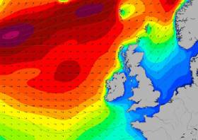
Published in Weather

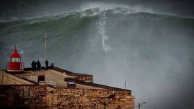
#RecordWave - Nineteen metres is the height of what’s being called the world’s largest wave, recorded recently off the North West Coast of Ireland.

Independent.ie reports on the record-breaking swell detected by a weather buoy in the North Atlantic between Ireland and Iceland, following what the World Meteorological Organization’s (WMO) Commission for Climatology described as a “very strong” cold front that passed through at more than 80km per hour.

WMO Assistant Secretary-General Wenjian Zhang said: ”This is the first time we have ever measured a wave of 19 metres. It is a remarkable record.”

The new measurement beats the previous record of 18.275 metres recorded in the North Atlantic nine years ago.

But while the news is causing gasps around the internet, for some it only confirms what’s long been known — that Ireland is on the doorstep of a big wave paradise.

Indeed, Ireland’s North West is no stranger to monster swells, with the giant surf offshore from Mullaghmore in Co Sligo a well-kept secret among the big wave surfing fraternity.

Published in Coastal Notes

#BullochHarbour – Afloat in October reported of a planning application for a mixed development scheme at the former premises of Western Marine at Dalkey’s Bulloch Harbour, whose waters are under pilotage district of Dublin Port Company, writes Jehan Ashmore.

The developer Bartra Property Ltd has sought planning permission for commercial and residential units located at the scenic south Dublin Bay harbour's waterfront site. It is because of this coastal site that has led to fears by locals and from a newly formed Bulloch Harbour Preservation Group. In addition Dalkey Community Council has since held meetings with the developers, citing concerns that the development will have a big impact on the harbour as a recreational and historical amenity for locals and tourists alike.

Western Marine which has yet to reveal its new home, having for almost half a century occupied the Bulloch Harbour site to where if granted permission the development would require demolition of the existing former chandlery warehouses. The development would involve the construction of six terraced homes over “marine-based activity units” and a quayside café.

It is along this stone-cut quayside hewn of Dalkey granite, is where recent developments to improve the harbour took place throughout the summer, notably the removal of a redundant five tonnes boat-hoist crane, property of Dublin Port Company. The harbour in past times used to have larger vessels trading that saw coal imported by steam-powered colliers.

The improvement works were carried out by the joint efforts of Dublin Port Company, Bulloch Harbour Group and Dalkey Tidy Towns to transform the harbour. Asides the aforementioned removal of the boat-crane coloured in distinctive pale blue, associated works involved upgrading of boat storage areas. Boat users also have new quay wall ladders and use of a refurbished slipway.

Bulloch Harbour is one of the last working harbours in Dublin Bay with its small inshore fishing boats, a large boat-hire fleet popular with anglers during the summer months along with marine leisure users mostly kayakers. The harbour is also home to the 3rd Port / 41st Dublin-Dalkey Sea Scouts which celebrates this year a 60th anniversary.

As to the origins of the quaint harbour where still stands Bulloch Castle built in the 12th century overlooking the present day harbour entrance. The castle towerhouse was established by the Cistercian monks along with lucrative fishing rights. The castle afforded protection for the Monks from that of the marauding Wicklow tribes.

Also as part of the improvement works saw the removal of the rotting boat flower bed and its restoration was completed next to the RNLI flag staff.  There is no RNLI station located here but the local lifeboat RNLB Anna Livia from Dun Laoghaire Harbour does make visits to Bulloch for the annual 'Blessing of the Boats" ceremony. 

The blessing service sees the 'Trent' class lifeboat berth alongside the harbour’s broad pier where coal was discharged. For a photo and more about  ‘Maritime Dalkey’ (a five year long series) published in the September 2013 issue, click the Dalkey Community Council (newsletters) website.

According to the current newsletter, Dalkey Tidy Towns say that the harbour's improvement is a work in progress with more planned in 2017. 


Published in Dublin Bay
Page 1 of 24

General Information on using Waterways Ireland inland navigations

Safety on the Water

All users of the navigations are strongly recommended to make themselves aware of safety on the water for whatever activity they are involved in and to read the advice offered by the various governing bodies and by:

The Dept. of Transport, Ireland: www.gov.ie/transport and The Maritime and Coastguard Agency, UK, The RNLI – Water Safety Ireland for information in terms of drowning prevention and water safety.

Registration of Vessels

All vessels using the Shannon Navigation, which includes the Shannon-Erne Waterways and the Erne System must be registered with Waterways Ireland. Only open undecked boats with an engine of 15 horsepower or less on the Shannon Navigation, and vessels of 10 horsepower or less on the Erne System, are exempt. Registration is free of charge.

Craft registration should be completed online at: https://www.waterwaysireland.org/online-services/craft-registration

Permits for use of the Grand and Royal Canals and the Barrow Navigation

All vessels using the Grand and Royal Canals and the Barrow Navigation must display appropriate valid Permit(s) i.e A Combined Mooring and Passage Permit (€126) and if not intending to move every five days, an Extended Mooring Permit (€152).

Permit applications should be completed online at: https://www.waterwaysireland.org/online-services/canal-permits

Passage on the Royal and Grand Canals – Dublin Area

For boat passage through the locks east of Lock 12 into / out of Dublin on either the Royal or Grand Canals, Masters are requested to contact the Waterways Ireland Eastern Regional Office (M-F 9.30am-4.30pm) on tel: +353(0)1 868 0148 or email [email protected] prior to making passage in order to plan the necessary lock-keeping assistance arrangements.

On the Grand Canal a minimum of two days notice prior to the planned passage should be given, masters should note that with the exception of pre-arranged events, a maximum of 2 boats per day will be taken through the locks, travelling either east or west.

Movements in or out of the city will be organised by prior arrangement to take place as a single movement in one day. Boaters will be facilitated to travel the system if their passage is considered to be safe by Waterways Ireland and they have the valid permit(s) for mooring and passage.

Newcomen Lifting Bridge

On the Royal Canal two weeks’ notice of bridge passage (Newcomen Lifting Bridge) is required for the pre-set lift date, and lock assistance will then also be arranged. A minimum of 2 boats is required for a bridge lift to go ahead.

Waterways Ireland Eastern Regional Office (Tel: +353(0)1 868 0148 or [email protected] ) is the point of contact for the bridge lift.

A maximum number of boats passing will be implemented to keep to the times given above for the planned lifts (16 for the Sat / Sun lifts & 8 for the weekday lifts). Priority will be given on a first come first served basis.

On day of lift, boaters and passengers must follow guidance from Waterways Ireland staff about sequence of passage under bridge & through Lock 1, and must remain within signed and designated areas.

Events Held on the Waterways

All organised events taking place on the waterways must have the prior approval of Waterways Ireland. This is a twelve week process and application forms must be accompanied with the appropriate insurance, signed indemnity and risk assessment. The application should be completed on the Waterways Ireland events page at :

https://www.waterwaysireland.org/online-services/event-approval

Time Limits on Mooring in Public Harbours

On the Shannon Navigation and the Shannon-Erne Waterway craft may berth in public harbours for five consecutive days or a total of seven days in any one month.

On the Erne System, revised Bye Laws state that: No master or owner shall permit a vessel, boat or any floating or sunken object to remain moored at or in the vicinity of any public mooring, including mooring at any other public mooring within 3 kilometres of that location, for more than 3 consecutive days and shall not moor at that same mooring or any other public mooring within 3 kilometres of that location within the following 3 consecutive days without prior permission by an authorised official.

Winter Mooring on the Shannon Navigation and Shannon Erne Waterway

Winter mooring may be availed of by owners during the period 1 Nov to 31 Mar by prior arrangement and payment of a charge of €63.50 per craft. Craft not availing of Winter Mooring must continue to comply with the “5 Day Rule”. Winter Mooring applications should be completed online at : https://www.waterwaysireland.org/online-services/winter-moorings-booking

Owners should be aware that electricity supply and water supply to public moorings is disconnected for the winter months. This is to protect against frost damage, to reduce running costs and to minimise maintenance requirements during the winter months.

Vessel owners are advised that advance purchasing of electricity on the power bollards leading up to the disconnection date should be minimal. Electricity credit existing on the bollards will not be recoverable after the winter decommissioning date. Both services will be reinstated prior to the commencement of the next boating season.

Smart Cards

Waterways Ireland smart cards are used to operate locks on the Shannon Erne Waterway, to access the service blocks, to use the pump-outs along the navigations, to avail of electrical power at Waterways Ireland jetties.

Berthing in Public Harbours

Masters are reminded of the following:

  • Equip their vessel with mooring lines of appropriate length and strength and only secure their craft to mooring bollards and cleats provided for this purpose.
  • Ensure the available berth is suitable to the length of your vessel, do not overhang the mooring especially on finger moorings on floating pontoon moorings.
  • Ensure mooring lines, electric cables and fresh water hoses do not create a trip hazard on public jetties for others users.
  • Carry sufficient fenders to prevent damage to your own vessel, other vessels and WI property.
  • Allow sufficient space between your vessel and the vessel ahead /astern (c.1m) for fire safety purposes and /or to recover somebody from the water.
  • Do not berth more than two vessels side by side and ensure there is safe access/egress at all times between vessels and onto the harbour itself.
  • Do not berth in such a way to prevent use of harbour safety ladders, slipways or pump-outs.
  • Do not allow the bow of your vessel to overhang the walkway of a floating mooring thus creating a hazard for others with an overhanging anchor or bow fendering.
  • Animals are not allowed to be loose or stray at any time.
  • Harbour and jetty infrastructure such as railings, power pedestals, fresh water taps, electric light poles, safety bollards, ladders etc are not designed for the purpose of mooring craft , they will not bear the strain of a vessel and will be damaged.
  • At Carrybridge on the Erne System, Masters of vessels are not permitted to use stern on mooring. Masters of vessels must use the mooring fingers for mooring of vessels and for embarkation / disembarkation from vessels.

Passenger Vessel Berths

Masters of vessels should not berth on passenger vessel berths where it is indicated that an arrival is imminent. Passenger vessels plying the navigations generally only occupy the berths to embark and disembark passengers and rarely remain on the berths for extended periods or overnight.

Lock Lead-in Jetties

Lead-in jetties adjacent to the upstream and downstream gates at lock chambers are solely for the purpose of craft waiting to use the lock and should not be used for long term berthing.

Vessel Wake

Vessel wake, that is, the wave generated by the passage of the boat through the water, can sometimes be large, powerful and destructive depending on the hull shape and engine power of the vessel. This wake can be detrimental to other users of the navigation when it strikes their craft or inundates the shoreline or riverbank. Masters are requested to frequently look behind and check the effect of their wake / wash particularly when passing moored vessels, on entering harbours and approaching jetties and to be aware of people pursuing other activities such as fishing on the riverbank.

Speed Restriction

A vessel or boat shall not be navigated on the Shannon Navigation at a speed in excess of 5 kph when within 200 metres of a bridge, quay, jetty or wharf, when in a harbour or canal or when passing within 100 metres of a moored vessel or boat.

Vessels navigating the Shannon-Erne Waterway should observe the general 5 kph speed limit which applies along the waterway. This is necessary in order to prevent damage to the banks caused by excessive wash from vessels.

Vessels navigating the Erne System should observe the statutory 5kt / 6mph / 10kph speed limit areas.

A craft on the Royal and Grand canals shall not be navigated at a speed in excess of 6km per hour.

A craft on the Barrow Navigation shall not be navigated at a speed in excess of 11km per hour except as necessary for safe navigation in conditions of fast flow.

Bank Erosion

Narrow sections of all the navigations are particularly prone to bank erosion due to the large wash generated by some craft. Masters are requested to be vigilant and to slow down to a speed sufficient to maintain steerage when they observe the wash of their craft inundating the river banks.

Unusual Waterborne Activity

Unusual waterborne vessels may be encountered from time to time, such as, hovercraft or amphibious aircraft / seaplanes. Masters of such craft are reminded to apply the normal “Rule of the Road” when they meet conventional craft on the water and to allow extra room to manoeuvre in the interest of safety.

Sailing Activity

Mariners will encounter large numbers of sailing dinghies from late June to August in the vicinity of Lough Derg, Lough Ree and Lower Lough Erne. Sailing courses are marked by yellow buoys to suit weather conditions on the day. Vessels should proceed at slow speed and with due caution and observe the rules of navigation when passing these fleets, as many of the participants are junior sailors under training.

Rowing

Mariners should expect to meet canoes and vessels under oars on any part of the navigations, but more so in the vicinity of Athlone, Carrick-on-Shannon, Coleraine, Enniskillen and Limerick. Masters are reminded to proceed at slow speed and especially to reduce their wash to a minimum when passing these craft as they can be easily upset and swamped due to their very low freeboard and always be prepared to give way in any given traffic situation.

Canoeing

Canoeing is an adventure sport and participants are strongly recommended to seek the advice of the sport’s governing bodies i.e Canoeing Ireland and the Canoe Association of Northern Ireland, before venturing onto the navigations.

Persons in charge of canoes are reminded of the inherent danger to these craft associated with operating close to weirs, sluice gates, locks and other infrastructure particularly when rivers are in flood and large volumes of water are moving through the navigations due to general flood conditions or very heavy localised precipitation e.g. turbulent and broken water, stopper waves. Shooting weirs is prohibited without prior permission of Waterways Ireland.

Canoeists should check with lockkeepers prior entering a lock to ensure passage is done in a safe manner. Portage is required at all unmanned locks.

Canoe Trail Network – "Blueways"

Masters of powered craft are reminded that a canoe trail network is being developed across all navigations and to expect more organised canoeing along these trails necessitating slow speed and minimum wash when encountering canoeists, rowing boats etc

Rockingham and Drummans Island Canals – Lough Key

It is expected that work on Rockingham and Drummans Island Canals on Lough Key will be completed in 2021. Access to these canals will be for non-powered craft only, eg canoes, kayaks, rowing boats.

Fast Powerboats and Personal Watercraft (Jet Skis)

Masters of Fast Powerboats (speed greater than 17kts) and Personal Watercraft (i.e.Jet Skis) are reminded of the inherent dangers associated with high speed on the water and especially in the confines of small bays and narrow sections of the navigations. Keeping a proper look-out, making early alterations to course and /or reducing speed will avoid conflict with slower vessels using the navigation. Personal Watercraft are not permitted to be used on the canals.

Towing Waterskiers, Wakeboarders, Doughnuts etc

Masters of vessels engaged in any of these activities are reminded of the manoeuvring constraints imposed upon their vessel by the tow and of the added responsibilities that they have to the person(s) being towed. These activities should be conducted in areas which are clear of conflicting traffic. It is highly recommended that a person additional to the master be carried to act as a “look-out” to keep the tow under observation at all times.

Prohibition on Swimming

Swimming in the navigable channel, particularly at bridges, is dangerous and is prohibited due to the risk of being run over by a vessel underway in the navigation.

Age Restrictions on operating of powered craft

In the Republic of Ireland, Statutory Instrument 921 of 2005 provides the legal requirements regarding the minimum age for operating of powered craft. The Statutory Instrument contains the following requirements:

- The master or owner of a personal watercraft or a fast power craft shall take all reasonable steps to ensure that a person who has not attained the age of 16 years does not operate or control the craft

- The master or owner of a pleasure craft powered by an engine with a rating of more than 5 horse power or 3.7 kilowatts shall take all reasonable steps to ensure that a person who has not attained the age of 12 years does not operate or control the craft.

Lifejackets and Personal Flotation Devices (PFDs)

Lifejackets and PFD’s are the single most important items of personal protective equipment to be used on a vessel and should be worn especially when the vessel is being manoeuvred such as entering / departing a lock, anchoring, coming alongside or departing a jetty or quayside.

In the Republic of Ireland, Statutory Instrument 921 of 2005 provides the legal requirements regarding the wearing of Personal Flotation Devices. The Statutory Instrument contains the following requirements:

- The master or owner of a pleasure craft (other than a personal watercraft) shall ensure, that there are, at all times on board the craft, sufficient suitable personal flotation devices for each person on board.

- A person on a pleasure craft (other than a personal watercraft) of less than 7 metres length overall shall wear a suitable personal flotation device while on board an open craft or while on the deck of decked craft, other than when the craft is made fast to the shore or at anchor.

- The master or owner of a pleasure craft (other than a personal watercraft) shall take all reasonable steps to ensure that a person who has not attained the age of 16 years complies with paragraph above.

- The master or owner of a pleasure craft (other than a personal watercraft), shall take all reasonable steps to ensure that a person who has not attained the age of 16 years wears a suitable personal flotation device while on board an open craft or while on the deck of a decked craft other than when it is made fast to the shore or at anchor.

- The master or owner of a pleasure craft (other than a personal watercraft) shall take all reasonable steps to ensure that a person wears a suitable personal flotation device, at all times while – (a) being towed by the craft, (b) on board a vessel or object of any kind which is being towed by the craft.

Further information is available at: http://www.irishstatutebook.ie/eli/2005/si/921/made/en/print

Firing Range Danger Area – Lough Ree

The attention of mariners is drawn to the Irish Defence Forces Firing Range situated in the vicinity of buoys No’s 2 and 3, on Lough Ree on the Shannon Navigation. This range is used regularly for live firing exercises, throughout the year, all boats and vessels should stay clear of the area marked with yellow buoys showing a yellow "X" topmark and displaying the word "Danger".

Shannon Navigation, Portumna Swing Bridge Tolls

No attempt should be made by Masters’ of vessels to pay the bridge toll while making way through the bridge opening. Payment will only be taken by the Collector from Masters when they are secured alongside the jetties north and south of the bridge.

Navigating from Killaloe to Limerick on the Shannon Navigation

The navigation from Killaloe to Limerick involves passage through Ardnacrusha locks, the associated headrace and tailrace and the Abbey River into Limerick City. Careful passage planning is required to undertake this voyage. Considerations include: lock passage at Ardnacrusha, water flow in the navigation, airdraft under bridges on Abbey River in Limerick, state of tide in Limerick

Users are advised to contact the ESB Ardnacrusha hydroelectric power station (00353 (0)87 9970131) 48 hours in advance of commencing their journey to book passage through the locks at Ardnacrusha. It is NOT advised to undertake a voyage if more than one turbine is operating (20MW), due to the increased velocity of flow in the navigation channel, which can be dangerous. To ascertain automatically in real time how many turbines are running, users can phone +353 (0)87 6477229.

For safety reasons the ESB has advised that only powered craft with a capacity in excess of 5 knots are allowed to enter Ardnacrusha Headrace and Tailrace Canals.

Passage through Sarsfield Lock should be booked on +353-87-7972998, on the day prior to travel and it should be noted also that transit is not possible two hours either side of low water.

A Hydrographic survey in 2020 of the navigation channel revealed that the approach from Shannon Bridge to Sarsfield Lock and the Dock area has silted up. Masters of vessels and water users are advised to navigate to the Lock from Shannon bridge on a rising tide one or two hours before High Tide.

Lower Bann Navigation

The attention of all users is drawn to the “Users Code for the Lower Bann”, in particular to that section covering “Flow in the River” outlining the dangers for users both on the banks and in the navigation, associated with high flow rates when the river is in spate. Canoeists should consult and carry a copy of the “Lower Bann Canoe Trail” guide issued by the Canoe Association of Northern Ireland. Users should also contact the DfI Rivers Coleraine, who is responsible for regulating the flow rates on the river, for advisory information on the flow rates to be expected on any given day.

DfI Rivers Coleraine. Tel: 0044 28 7034 2357 Email: [email protected]

Lower Bann Navigation – Newferry – No wake zone

A No Wake Zone exists on the Lower Bann Navigation at Newferry. Masters of vessels are requested to proceed at a slow speed and create no wake while passing the jetties and slipways at Newferry.

Overhead Power Lines (OHPL) and Air draft

All Masters must be aware of the dangers associated with overhead power lines, in particular sailing vessels and workboats with cranes or large air drafts. Voyage planning is a necessity in order to identify the location of overhead lines crossing the navigation.

Overhead power line heights on the River Shannon are maintained at 12.6metres (40 feet) from Normal Summer level for that section of navigation, masters of vessels with a large air draft should proceed with caution and make additional allowances when water levels are high.

If a vessel or its equipment comes into contact with an OHPL the operator should NOT attempt to move the vessel or equipment. The conductor may still be alive or re-energise automatically. Maintain a safe distance and prevent third parties from approaching due to risk of arcing. Contact the emergency services for assistance.

Anglers are also reminded that a minimum ground distance of 30 metres should be maintained from overhead power lines when using a rod and line.

Submarine Cables and Pipes

Masters of vessels are reminded not to anchor their vessels in the vicinity of submarine cables or pipes in case they foul their anchor or damage the cables or pipes. Look to the river banks for signage indicating their presence.

Water Levels - Precautions

Low Water Levels:

When water levels fall below normal summer levels masters should be aware of:

Navigation

To reduce the risk of grounding masters should navigate on or near the centreline of the channel, avoid short cutting in dog-legged channels and navigating too close to navigation markers.

Proceeding at a slow speed will also reduce “squat” effect i.e. where the vessel tends to sit lower in the water as a consequence of higher speed.

Slipways

Reduced slipway length available under the water surface and the possibility of launching trailers dropping off the end of the concrete apron.

More slipway surface susceptible to weed growth requiring care while engaged in launching boats, from slipping and sliding on the slope. Note also that launching vehicles may not be able to get sufficient traction on the slipway once the craft is launched to get up the incline.

Bank Erosion

Very dry riverbanks are more susceptible to erosion from vessel wash.

Lock Share

Maximising on the number of vessels in a lock will ensure that the total volume of water moving downstream is decreased. Lock cycles should be used for vessels travelling each way.

High Water Levels:

When water levels rise above normal summer level masters should be aware of:

Navigation

Navigation marks will have reduced height above the water level or may disappear underwater altogether making the navigable channel difficult to discern.

In narrow sections of the navigations water levels will tend to rise more quickly than in main streams and air draft at bridges will likewise be reduced.

There will also be increased flow rates particularly in the vicinity of navigation infrastructure such as bridges, weirs, locks etc where extra care in manoeuvring vessels will be required.

Harbours and Jetties

Due care is required in harbours and at slipways when levels are at or near the same level as the harbour walkways' as the edge will be difficult to discern especially in reduced light conditions. It is advised that Personal Flotation Devices be worn if tending to craft in a harbour in these conditions.

Slipways

Slipways should only be used for the purpose of launching and recovering of water craft or other objects from the water. Before using a slipway it should be examined to ensure that the surface has sufficient traction/grip for the intended purpose such as launching a craft from a trailer using a vehicle, that there is sufficient depth of water on the slipway to float the craft off the trailer before the concrete apron ends and that the wheels of the trailer do not drop off the edge of the slipway. That life-saving appliances are available in the vicinity, that the vehicle is roadworthy and capable of coping with the weight of the trailer and boat on the incline. It is recommended that slipway operations are conducted by two persons.

Caution to be Used in Reliance upon Aids to Navigation

The aids to navigation depicted on the navigation guides comprise a system of fixed and floating aids to navigation. Prudent mariners will not rely solely on any single aid to navigation, particularly a floating aid to navigation. With respect to buoys, the buoy symbol is used to indicate the approximate position of the buoy body and the ground tackle which secures it to the lake or river bed. The approximate position is used because of the practical limitations in positioning and maintaining buoys in precise geographical locations. These limitations include, but are not limited to, prevailing atmospheric and lake/river conditions, the slope of and the material making up the lake/river bed, the fact that the buoys are moored to varying lengths of chain, and the fact that the buoy body and/or ground tackle positions are not under continuous surveillance. Due to the forces of nature, the position of the buoy body can be expected to shift inside and outside the charted symbol.

Buoys and perches are also moved out of position or pulled over by those mariners who use them to moor up to instead of anchoring. To this end, mariners should always monitor their passage by relating buoy/perch positions with the published navigation guide. Furthermore, a vessel attempting to pass close by always risks collision with a yawing buoy or with the obstruction that the buoy or beacon/perch marks.

Masters of Vessels are requested to use the most up to date Navigation guides when navigating on the Inland Waterways.

Information taken from Special Marine Notice No 1 of 2023