Menu

Ireland's sailing, boating & maritime magazine

Inland afloat headers


Displaying items by tag: Coastwatch

Progress on eradicating single use plastics which are so harmful to the marine environment will be discussed at a workshop hosted by Coastwatch later this month.

The “Coastwatch and more4nature Earth Day 2024 workshop” will celebrate the disappearance of most items banned under the single use plastics directive since June 2021.

The Coastwatch marine litter citizen science surveys' tracking will be discussed, along with single-use plastics that are “ban-resistant.”

Law and law enforcement, the campaign route and “good practice examples” will also be discussed by contributors from the EU’s environment directorate, the Department of the Environment, the Environmental Protection Agency and environmental NGOs.

The event will take place in Europe House, 12-14 Lr Mount Street, Dublin, on April 22nd from 9 am to 1 pm. Booking is essential, and more information is available from Karin Dubsky at email [email protected]

Published in Marine Wildlife

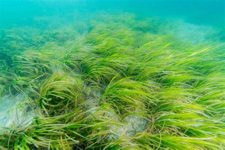
Coastal nature protection, management and restoration is the theme of a Coastwatch seminar later this month.

The seminar on January 24th in Trinity College, Dublin will focus on seagrass habitat and the Nature Restoration Law.

It will also discuss progress of the Government’s marine protected area (MPA) legislation.

“We have entered a key year for biodiversity,”Coastwatch co-ordinator Karin Dubsky says.

“ In 2023, reports by the Citizen Assembly on biodiversity loss and then the Joint Committee on the Environment and Climate Action were published,” she recalled.

“The EU Nature Restoration Law should pass in February/March and the Irish MPA law follow soon afterwards,” she said.

“The Nature Restoration Law and ongoing measures to designate, manage and restore Natura 2000 sites, offer new opportunities for public participation and citizen science,” she said.

“This Coastwatch seminar will provide an opportunity to review these initiatives against the needs in the coastal zone, where nature is struggling,” she said.

Two sessions will focus on seagrass, as one critically important inshore habitat, and the keynote address will be given by Dr Marcial Bardolet, head of the Posidonia Seagrass Surveillance Service, (IBANAT) Balearic Islands, Spain.

Registration is essential here

Published in Marine Wildlife

Coastwatch Environmental NGO is due to release the results of its autumn survey this evening (Monday, Dec 4).

Findings from almost 700 survey sites in the Republic will be presented at an online event, which can be viewed on Zoom.

Coastwatch has paid tribute to surveyors and citizen scientists who had to “duck and dive” between weather challenges.

“Storms and much higher rainfall than average surveys have coloured several aspects of our results,” it says. 

“With COP 28 in progress and local authorities drafting climate action plans, it is timely to consider what we need to do to better cope with such events,” it says.

In-person events are also due to take place on December 10th and 11th in Dublin.

More details are on the Coastwatch website, and registration for this evening’s autumn survey results on Zoom is here

Published in Marine Wildlife
Tagged under

Coastwatch is appealing for citizen scientists to join its annual shore survey, which runs until mid-October.

Already, three volunteer surveyors have identified seagrass beds and meadows in counties Wexford, Dublin and Galway.

Some shorelines which had suffered plastic pollution after bad weather are also reportedly relatively cleaner or free of plastic, according to Coastwatch co-ordinator Karin Dubsky.

However, huge numbers of dying cockles have also been reported on Duncannon shore, Co Wexford, while carpets of green algae and sludge layers have been reported in parts of Dublin Bay and west Cork.

The survey involves volunteers from all walks of life who select 500 metres of shore as a survey unit.

The “eco-audit” of the selected area takes about an hour, during low tide, with friends or family.

“College and school groups, scouts and kayakers are also welcome to join,” Dubsky said.

“Weather permitting the survey effort will peak next weekend at the lowest tides,” she said.

All the required materials, except for water test kits, are on the Coastwatch website where survey sites can also be booked. Coastwatch regional co-ordinators can also help newcomers and groups, she says.

Details on participation involve the following steps, she says:

  • 1. Chose a 500m survey unit and book it online www.coastwatch.org
  • 2. Read the survey form and guide notes and download ID posters for marine life.
  • 3. Join an online training or field work group session if you are new or would like to refresh. Next online session is Mon 25th Sept at 1800 hours.
  • 4. Check your shore around low tide and record your findings in photos/on survey form.
  • 5. Report back on new phone app, or computer input forms or by posting your results to us.

“We then collate and analyse data to share and discuss it in Trinity College Dublin on December 23rd,” she says.

“Coastwatchers are also invited to an international workshop to plan follow up action,” she says.

She says that Coastwatch is grateful to the Department of Housing marine unit for extra support this year.

A cross-border survey for Lough Foyle is planned for Sunday, Oct 1st.

More details are here

Published in Marine Wildlife
Tagged under

Coastwatch has appealed for volunteers to join its annual autumn shore survey, which runs from mid-September to mid-October.

“This is now one of the longest standing citizen science projects in Ireland,” Coastwatch founder Karin Dubsky says.

” It’s a basic eco-audit of the shore carried out around low tide between Sept 15th and Oct 15th,” she says.

“You can go out as a group, divide tasks between you and cover long dune stretches in one sweep, having fun at the same time; or you go in pairs or alone to a favourite quiet spot,” Dubsky explains.

The Dublin Bay shoreline will be part of the Coastwatch survey Photo: Karin DubsyThe Dublin Bay shoreline will be part of the Coastwatch survey Photo: Karin Dubsy

“Either way, you are carefully observing, testing any streams you might cross and then report back on the state of that shore,” she says.

The annual citizen science audit started in 1987, with The Irish Times publishing a pull-out survey page.

It is now largely online with an accessible GIS map to choose sites to survey once between Sept 15th and Oct 15th, Dubsky says.

Volunteers book their site on an interactive map and download materials, or ask Coastwatch for these, Dubsky says.

They can “zig-zag” their chosen 500m of shore around low tide to record and report their findings from erosion to stream water quality, using test kits, and record key animals and plants along with waste and litter, she explains.

Micro litter can also be recorded, using a Coastwatch developed app, Dubsky says.

The first results will be presented in early December at Trinity College Dublin.

The Bull island lagoon, Dublin Bay with wet wipes close to an outflow pipe Photo: Gereon GuenterThe Bull island lagoon, Dublin Bay with wet wipes close to an outflow pipe Photo: Gereon Guenter

Dubsky says training is provided for new volunteers, and regional coordinators are planning joint survey events to cover some areas really well.

‘This year, we focus on the quality of small streams, seagrass and on litter which would be better addressed by prevention and law than by clean-ups,” Michael Walsh of the Coastwatch team says.

“Small coastal streams may not look impressive but can host fish like seatrout and eel,” John Cullen, one of the Coastwatch team scientists, explains.

“In a training session last week, we checked a tiny stream flowing through Tintern Abbey walled gardens, Co Wexford”, Dubsky says.

“It was full of life and young sea trout are regularly observed here. We would love to mark such streams with big smiley faces on our maps and help restore other streams which we find in a dead or sad state,” she says.

‘With bird flu hitting many seabird colonies, we are now also asking for photographs and to report dead birds to DAFM using the Avian Flu reporting app or hotline so they can pick up and test for flu,” she says.

This will be the third year of recording COVID-related litter, and the first full year since government restrictions on a range of single-use plastics (SUP) has been implemented.

A three-year snapshot of Covid-related litter and SUP plastic will be published in December, she said.

All materials are on the Coastwatch website www.coastwatch.org or available from coordinators.

Published in Coastal Notes

Inland Fisheries Ireland (IFI) says it is investigating a “very concerning” claim by Coastwatch that a local authority is chlorinating local streams which flow into a popular southeast beach.

Coastwatch spokeswoman Karin Dubsky says that children are at risk, along with stream life, due to the use of sodium hypochlorite to disinfect water flowing into a designated bathing water area at Dunmore East, Co Waterford.

Coastwatch has filed a report on the issue to the Environmental Protection Agency (EPA).

In its report to the EPA, Coastwatch says that the water quality in the two streams is poor or not dependable, and “apparently has been problematic for decades”.

Coastwatch spokeswoman Karin DubskyCoastwatch spokeswoman Karin Dubsky

It notes that authorities use this disinfection practise to kill faecal microbes and protect the health of bathers and children playing in the stream.

“However it also kills all stream life and exposes small children playing in the stream mouth to chlorine vapours and chlorinated stream water, which can have significant health effects,” it says.

“There are no warnings to the public to take this risk into account. Furthermore, the drip sites – especially the westerly one - are easily accessible to exploring children. Contact with a drip can result in serious burns and possible loss of eyesight,”it says.

“While this appears to be contrary to the Water Pollution Act 1977 Section 3 and other legislation, Coastwatch was told first verbally and then in writing that it would continue for public health reasons,” it says.

Waterford City and County Council said it disputes Coastwatch Ireland’s claim that it is in breach of the Water Pollution Act.

“Two streams flowing into Dunmore East bathing area are chlorinated during the summer bathing season and have been for a number of years,” Waterford City and County Council said in a statement.

“This is due to diffuse and unidentified point source pollution sources upstream of the beach. The chlorine is driven off by the motion of the water and as such is unlikely to affect the flora and fauna in the bay and certainly not as much as some beach users leaving their rubbish, discarded plastics and other waste,” it said.

“The stream is chlorinated upstream of the culvert to the beach, primarily because children tend to play in the stream despite notices being erected advising adults/parents that it is unsafe to do so,” the local authority said.

“The purpose of the chlorination plant is primarily to protect human health from the impact of diffuse pollution sources further upstream,” it said.

Inland Fisheries Ireland said it had received communication last week from the EPA on the issue.

“The issues raised are very concerning, and Inland Fisheries Ireland will investigate the matter immediately, from a fisheries perspective,” it said.

It asked members of the public to report any suspected water pollution incidents to its new confidential hotline number on 0818 34 74 24, which is open 24 hours a day.

Published in Coastal Notes

Coastwatch has welcomed the promise of greater protections for sensitive maritime areas in the Marine Spatial Planning Bill as it continues its annual shoreline survey.

As reported in The Irish Times, the environmental group’s coordinator Karin Dubsky said “public participation will be an integral part” of the process when the bill, which was published last month, passes into law.

Hundreds of volunteers are already deep into the four-week survey of Ireland’s 7,500km coastline, which continues till Friday 15 October.

This year Coastwatch is making a special appeal for farmers and coastal landowners to get involved to record the status of seaside habitats.

“Most of Ireland’s of shore is owned by farmers, yet we rarely hear how coastal farmers and how they are dealing with climate change and sea level rise,” Cork Coastwatch coordinator Bernie Connolly said.

The Irish Times has more on the story HERE.

Published in Marine Planning
Tagged under

Waterford inshore fisherman Sean Doherty will share his knowledge of eels with primary school children in Passage East, Waterford to mark World River Day this week.

The students will be given a demonstration on nets and eel tagging at Cheekpoint harbour, where the rivers Barrow, Nore and Suir - the so-called “three sisters” – meet.

They will also participate in a search for eels under stones and will be shown how eels are released back into the water, according to Coastwatch coordinator Karin Dubsky.

World Rivers Day takes place annually on the fourth Sunday of September, but this event is being held on Thursday to allow students to mark the occasion.

World Rivers DayWorld Rivers Day

It is being hosted by Coastwatch and Inland Fisheries Ireland, with the support of the Local Authorities Water Programme.

The focus is on eels, as they are now a “red-listed” species at risk throughout Europe, due to a collapse in numbers, Dubsky said.

“All eel fishing in the Republic of Ireland has been closed for a number of years,” she said.

Pupils will hear how the “diachronous” species spawn in the Sargasso Sea and how they arrive on European shores where they mark several live stages.

“We will look at where eels live, monitoring and what might be done to restore eel habitat and increase survival in Ireland,” she said.

Published in Marine Wildlife

A natural marine resource more important than the rain forests is in danger of dying out unless funding is provided to help protect it.

Zostera Marina is a type of seagrass which grows in the inshore areas of south Wexford, it supports biodiversity, cleans the surrounding water and helps take carbon dioxide out of the atmosphere. However, local seagrass habitats are under threat from the invasive species Sargassum muticum, or ‘wire weed’, which stunts its growth and eventually kills it.

Mick Berry of Coastwatch and local environmentalist Karin Dubsky invited members of the public and government officials to St Patrick’s Bridge in Kilmore Quay to highlight the importance of seagrass and the urgent need to safeguard its future. “England has already lost 92 per cent of its sea grass and Ireland’s levels are patchy, we don’t know how much is left,” said Mick. “We need to map it around the coast of Wexford and identify where it might be. People don’t know what it looks like, even the people living here in Kilmore, they get it mixed up with green algae. At the moment no one is doing anything to preserve it, there’s a lot of red tape holding everything up.”

As a coastal county, Wexford is at the forefront of this fight to protect this vital plant. “Seagrass is one of the top plants for sequestering ocean carbon, its way ahead of the rain forest, it’s so important and it’s right on our doorstep, there’s lots of it in Wexford,” explained Mick. “We’re pushing for funding so we can go out and find it. But we need divers to go and look for it in certain areas, the government department should be doing this not us, we’re doing it out of love.” 

Salvation may yet be at hand in the form of the new Maritime Area Planning Bill which is currently before the Oireachteas and includes plans to give local authorities a role in managing inshore coastal areas. It was published on June 29 and coincided with the launch of the National Marine Planning Framework, Ireland’s first national framework for managing marine activities.

Wexford People has more. 

Published in Coastal Notes

The new Maritime Area Planning Bill is not solely designed “to help the offshore renewable sector get what it needs”, Coastwatch co-ordinator Karin Dubsky has warned.

The legislation, which marks a first for the State in marine planning, is “for all of us, and we have to watch that there isn’t a shortcut”, Dubsky said.

Her environmental group has called on the Government to specify protection of seagrass beds in the new legislation which comes before the Oireachtas this term.

Seagrass or Zostera marina is the inshore equivalent of coral reefs or tropical rainforests in nurturing habitats for diverse species and helping to filter sediments and keep shorelines stable.

“Seagrass can be found in sandy, muddy areas, such as near the high tide mark in Sligo. Short seagrass lawns have been well studied by the Environmental Protection Authority,”Dubsky said.

“The seagrass meadows rich in molluscs, fish and lobster are more difficult to find and the roots of this grass like to find shelter and clean water,”she said.

“Seagrass is incredibly important for climate change adaptation, and the meadows are totally understudied in Ireland,”she said

“Present legislation is chaotic, so it needs to be listed and mapped for protection,”she said.

“If the new Bill can state that seagrass is protected wherever it occurs, that would be very positive, “she said

Several Irish seagrass habitats are threatened by an invasive species known as “wire weed” or Sargassum muticum, she explained.

“These are some of our most valuable blue carbon habitats”, Dubsky said.

She hosted a special event at St Patrick’s Bridge near Kilmore Quay in Co Wexford last week to highlight the issue.

The new Maritime Area Planning Bill is geared to ensure regulated development of offshore wind farms, but gives local authorities a role in managing inshore coastal areas, she pointed out.

By specifying certain habitats requiring protection, this would empower local authorities to protect seagrass and to remove invasive species like Sargassum muticum, Dubsky said.

Seagrass beds in Co Wexford, in Bantry Bay, Co Cork and at Fenit in Tralee bay, Co Kerry are at risk from the invasive species, which is at its most dense in May and June, she said.

She said the protection needs to be acted upon now, as planned separate legislation on marine protected areas could take some years.

“There is huge potential to get things right, but also a huge potential to miss the boat as there is so much marine and coastal development now,”she said.

Karin Dubsky spoke to Wavelengths below

Published in Wavelength Podcast
Page 1 of 3

General Information on using Waterways Ireland inland navigations

Safety on the Water

All users of the navigations are strongly recommended to make themselves aware of safety on the water for whatever activity they are involved in and to read the advice offered by the various governing bodies and by:

The Dept. of Transport, Ireland: www.gov.ie/transport and The Maritime and Coastguard Agency, UK, The RNLI – Water Safety Ireland for information in terms of drowning prevention and water safety.

Registration of Vessels

All vessels using the Shannon Navigation, which includes the Shannon-Erne Waterways and the Erne System must be registered with Waterways Ireland. Only open undecked boats with an engine of 15 horsepower or less on the Shannon Navigation, and vessels of 10 horsepower or less on the Erne System, are exempt. Registration is free of charge.

Craft registration should be completed online at: https://www.waterwaysireland.org/online-services/craft-registration

Permits for use of the Grand and Royal Canals and the Barrow Navigation

All vessels using the Grand and Royal Canals and the Barrow Navigation must display appropriate valid Permit(s) i.e A Combined Mooring and Passage Permit (€126) and if not intending to move every five days, an Extended Mooring Permit (€152).

Permit applications should be completed online at: https://www.waterwaysireland.org/online-services/canal-permits

Passage on the Royal and Grand Canals – Dublin Area

For boat passage through the locks east of Lock 12 into / out of Dublin on either the Royal or Grand Canals, Masters are requested to contact the Waterways Ireland Eastern Regional Office (M-F 9.30am-4.30pm) on tel: +353(0)1 868 0148 or email [email protected] prior to making passage in order to plan the necessary lock-keeping assistance arrangements.

On the Grand Canal a minimum of two days notice prior to the planned passage should be given, masters should note that with the exception of pre-arranged events, a maximum of 2 boats per day will be taken through the locks, travelling either east or west.

Movements in or out of the city will be organised by prior arrangement to take place as a single movement in one day. Boaters will be facilitated to travel the system if their passage is considered to be safe by Waterways Ireland and they have the valid permit(s) for mooring and passage.

Newcomen Lifting Bridge

On the Royal Canal two weeks’ notice of bridge passage (Newcomen Lifting Bridge) is required for the pre-set lift date, and lock assistance will then also be arranged. A minimum of 2 boats is required for a bridge lift to go ahead.

Waterways Ireland Eastern Regional Office (Tel: +353(0)1 868 0148 or [email protected] ) is the point of contact for the bridge lift.

A maximum number of boats passing will be implemented to keep to the times given above for the planned lifts (16 for the Sat / Sun lifts & 8 for the weekday lifts). Priority will be given on a first come first served basis.

On day of lift, boaters and passengers must follow guidance from Waterways Ireland staff about sequence of passage under bridge & through Lock 1, and must remain within signed and designated areas.

Events Held on the Waterways

All organised events taking place on the waterways must have the prior approval of Waterways Ireland. This is a twelve week process and application forms must be accompanied with the appropriate insurance, signed indemnity and risk assessment. The application should be completed on the Waterways Ireland events page at :

https://www.waterwaysireland.org/online-services/event-approval

Time Limits on Mooring in Public Harbours

On the Shannon Navigation and the Shannon-Erne Waterway craft may berth in public harbours for five consecutive days or a total of seven days in any one month.

On the Erne System, revised Bye Laws state that: No master or owner shall permit a vessel, boat or any floating or sunken object to remain moored at or in the vicinity of any public mooring, including mooring at any other public mooring within 3 kilometres of that location, for more than 3 consecutive days and shall not moor at that same mooring or any other public mooring within 3 kilometres of that location within the following 3 consecutive days without prior permission by an authorised official.

Winter Mooring on the Shannon Navigation and Shannon Erne Waterway

Winter mooring may be availed of by owners during the period 1 Nov to 31 Mar by prior arrangement and payment of a charge of €63.50 per craft. Craft not availing of Winter Mooring must continue to comply with the “5 Day Rule”. Winter Mooring applications should be completed online at : https://www.waterwaysireland.org/online-services/winter-moorings-booking

Owners should be aware that electricity supply and water supply to public moorings is disconnected for the winter months. This is to protect against frost damage, to reduce running costs and to minimise maintenance requirements during the winter months.

Vessel owners are advised that advance purchasing of electricity on the power bollards leading up to the disconnection date should be minimal. Electricity credit existing on the bollards will not be recoverable after the winter decommissioning date. Both services will be reinstated prior to the commencement of the next boating season.

Smart Cards

Waterways Ireland smart cards are used to operate locks on the Shannon Erne Waterway, to access the service blocks, to use the pump-outs along the navigations, to avail of electrical power at Waterways Ireland jetties.

Berthing in Public Harbours

Masters are reminded of the following:

  • Equip their vessel with mooring lines of appropriate length and strength and only secure their craft to mooring bollards and cleats provided for this purpose.
  • Ensure the available berth is suitable to the length of your vessel, do not overhang the mooring especially on finger moorings on floating pontoon moorings.
  • Ensure mooring lines, electric cables and fresh water hoses do not create a trip hazard on public jetties for others users.
  • Carry sufficient fenders to prevent damage to your own vessel, other vessels and WI property.
  • Allow sufficient space between your vessel and the vessel ahead /astern (c.1m) for fire safety purposes and /or to recover somebody from the water.
  • Do not berth more than two vessels side by side and ensure there is safe access/egress at all times between vessels and onto the harbour itself.
  • Do not berth in such a way to prevent use of harbour safety ladders, slipways or pump-outs.
  • Do not allow the bow of your vessel to overhang the walkway of a floating mooring thus creating a hazard for others with an overhanging anchor or bow fendering.
  • Animals are not allowed to be loose or stray at any time.
  • Harbour and jetty infrastructure such as railings, power pedestals, fresh water taps, electric light poles, safety bollards, ladders etc are not designed for the purpose of mooring craft , they will not bear the strain of a vessel and will be damaged.
  • At Carrybridge on the Erne System, Masters of vessels are not permitted to use stern on mooring. Masters of vessels must use the mooring fingers for mooring of vessels and for embarkation / disembarkation from vessels.

Passenger Vessel Berths

Masters of vessels should not berth on passenger vessel berths where it is indicated that an arrival is imminent. Passenger vessels plying the navigations generally only occupy the berths to embark and disembark passengers and rarely remain on the berths for extended periods or overnight.

Lock Lead-in Jetties

Lead-in jetties adjacent to the upstream and downstream gates at lock chambers are solely for the purpose of craft waiting to use the lock and should not be used for long term berthing.

Vessel Wake

Vessel wake, that is, the wave generated by the passage of the boat through the water, can sometimes be large, powerful and destructive depending on the hull shape and engine power of the vessel. This wake can be detrimental to other users of the navigation when it strikes their craft or inundates the shoreline or riverbank. Masters are requested to frequently look behind and check the effect of their wake / wash particularly when passing moored vessels, on entering harbours and approaching jetties and to be aware of people pursuing other activities such as fishing on the riverbank.

Speed Restriction

A vessel or boat shall not be navigated on the Shannon Navigation at a speed in excess of 5 kph when within 200 metres of a bridge, quay, jetty or wharf, when in a harbour or canal or when passing within 100 metres of a moored vessel or boat.

Vessels navigating the Shannon-Erne Waterway should observe the general 5 kph speed limit which applies along the waterway. This is necessary in order to prevent damage to the banks caused by excessive wash from vessels.

Vessels navigating the Erne System should observe the statutory 5kt / 6mph / 10kph speed limit areas.

A craft on the Royal and Grand canals shall not be navigated at a speed in excess of 6km per hour.

A craft on the Barrow Navigation shall not be navigated at a speed in excess of 11km per hour except as necessary for safe navigation in conditions of fast flow.

Bank Erosion

Narrow sections of all the navigations are particularly prone to bank erosion due to the large wash generated by some craft. Masters are requested to be vigilant and to slow down to a speed sufficient to maintain steerage when they observe the wash of their craft inundating the river banks.

Unusual Waterborne Activity

Unusual waterborne vessels may be encountered from time to time, such as, hovercraft or amphibious aircraft / seaplanes. Masters of such craft are reminded to apply the normal “Rule of the Road” when they meet conventional craft on the water and to allow extra room to manoeuvre in the interest of safety.

Sailing Activity

Mariners will encounter large numbers of sailing dinghies from late June to August in the vicinity of Lough Derg, Lough Ree and Lower Lough Erne. Sailing courses are marked by yellow buoys to suit weather conditions on the day. Vessels should proceed at slow speed and with due caution and observe the rules of navigation when passing these fleets, as many of the participants are junior sailors under training.

Rowing

Mariners should expect to meet canoes and vessels under oars on any part of the navigations, but more so in the vicinity of Athlone, Carrick-on-Shannon, Coleraine, Enniskillen and Limerick. Masters are reminded to proceed at slow speed and especially to reduce their wash to a minimum when passing these craft as they can be easily upset and swamped due to their very low freeboard and always be prepared to give way in any given traffic situation.

Canoeing

Canoeing is an adventure sport and participants are strongly recommended to seek the advice of the sport’s governing bodies i.e Canoeing Ireland and the Canoe Association of Northern Ireland, before venturing onto the navigations.

Persons in charge of canoes are reminded of the inherent danger to these craft associated with operating close to weirs, sluice gates, locks and other infrastructure particularly when rivers are in flood and large volumes of water are moving through the navigations due to general flood conditions or very heavy localised precipitation e.g. turbulent and broken water, stopper waves. Shooting weirs is prohibited without prior permission of Waterways Ireland.

Canoeists should check with lockkeepers prior entering a lock to ensure passage is done in a safe manner. Portage is required at all unmanned locks.

Canoe Trail Network – "Blueways"

Masters of powered craft are reminded that a canoe trail network is being developed across all navigations and to expect more organised canoeing along these trails necessitating slow speed and minimum wash when encountering canoeists, rowing boats etc

Rockingham and Drummans Island Canals – Lough Key

It is expected that work on Rockingham and Drummans Island Canals on Lough Key will be completed in 2021. Access to these canals will be for non-powered craft only, eg canoes, kayaks, rowing boats.

Fast Powerboats and Personal Watercraft (Jet Skis)

Masters of Fast Powerboats (speed greater than 17kts) and Personal Watercraft (i.e.Jet Skis) are reminded of the inherent dangers associated with high speed on the water and especially in the confines of small bays and narrow sections of the navigations. Keeping a proper look-out, making early alterations to course and /or reducing speed will avoid conflict with slower vessels using the navigation. Personal Watercraft are not permitted to be used on the canals.

Towing Waterskiers, Wakeboarders, Doughnuts etc

Masters of vessels engaged in any of these activities are reminded of the manoeuvring constraints imposed upon their vessel by the tow and of the added responsibilities that they have to the person(s) being towed. These activities should be conducted in areas which are clear of conflicting traffic. It is highly recommended that a person additional to the master be carried to act as a “look-out” to keep the tow under observation at all times.

Prohibition on Swimming

Swimming in the navigable channel, particularly at bridges, is dangerous and is prohibited due to the risk of being run over by a vessel underway in the navigation.

Age Restrictions on operating of powered craft

In the Republic of Ireland, Statutory Instrument 921 of 2005 provides the legal requirements regarding the minimum age for operating of powered craft. The Statutory Instrument contains the following requirements:

- The master or owner of a personal watercraft or a fast power craft shall take all reasonable steps to ensure that a person who has not attained the age of 16 years does not operate or control the craft

- The master or owner of a pleasure craft powered by an engine with a rating of more than 5 horse power or 3.7 kilowatts shall take all reasonable steps to ensure that a person who has not attained the age of 12 years does not operate or control the craft.

Lifejackets and Personal Flotation Devices (PFDs)

Lifejackets and PFD’s are the single most important items of personal protective equipment to be used on a vessel and should be worn especially when the vessel is being manoeuvred such as entering / departing a lock, anchoring, coming alongside or departing a jetty or quayside.

In the Republic of Ireland, Statutory Instrument 921 of 2005 provides the legal requirements regarding the wearing of Personal Flotation Devices. The Statutory Instrument contains the following requirements:

- The master or owner of a pleasure craft (other than a personal watercraft) shall ensure, that there are, at all times on board the craft, sufficient suitable personal flotation devices for each person on board.

- A person on a pleasure craft (other than a personal watercraft) of less than 7 metres length overall shall wear a suitable personal flotation device while on board an open craft or while on the deck of decked craft, other than when the craft is made fast to the shore or at anchor.

- The master or owner of a pleasure craft (other than a personal watercraft) shall take all reasonable steps to ensure that a person who has not attained the age of 16 years complies with paragraph above.

- The master or owner of a pleasure craft (other than a personal watercraft), shall take all reasonable steps to ensure that a person who has not attained the age of 16 years wears a suitable personal flotation device while on board an open craft or while on the deck of a decked craft other than when it is made fast to the shore or at anchor.

- The master or owner of a pleasure craft (other than a personal watercraft) shall take all reasonable steps to ensure that a person wears a suitable personal flotation device, at all times while – (a) being towed by the craft, (b) on board a vessel or object of any kind which is being towed by the craft.

Further information is available at: http://www.irishstatutebook.ie/eli/2005/si/921/made/en/print

Firing Range Danger Area – Lough Ree

The attention of mariners is drawn to the Irish Defence Forces Firing Range situated in the vicinity of buoys No’s 2 and 3, on Lough Ree on the Shannon Navigation. This range is used regularly for live firing exercises, throughout the year, all boats and vessels should stay clear of the area marked with yellow buoys showing a yellow "X" topmark and displaying the word "Danger".

Shannon Navigation, Portumna Swing Bridge Tolls

No attempt should be made by Masters’ of vessels to pay the bridge toll while making way through the bridge opening. Payment will only be taken by the Collector from Masters when they are secured alongside the jetties north and south of the bridge.

Navigating from Killaloe to Limerick on the Shannon Navigation

The navigation from Killaloe to Limerick involves passage through Ardnacrusha locks, the associated headrace and tailrace and the Abbey River into Limerick City. Careful passage planning is required to undertake this voyage. Considerations include: lock passage at Ardnacrusha, water flow in the navigation, airdraft under bridges on Abbey River in Limerick, state of tide in Limerick

Users are advised to contact the ESB Ardnacrusha hydroelectric power station (00353 (0)87 9970131) 48 hours in advance of commencing their journey to book passage through the locks at Ardnacrusha. It is NOT advised to undertake a voyage if more than one turbine is operating (20MW), due to the increased velocity of flow in the navigation channel, which can be dangerous. To ascertain automatically in real time how many turbines are running, users can phone +353 (0)87 6477229.

For safety reasons the ESB has advised that only powered craft with a capacity in excess of 5 knots are allowed to enter Ardnacrusha Headrace and Tailrace Canals.

Passage through Sarsfield Lock should be booked on +353-87-7972998, on the day prior to travel and it should be noted also that transit is not possible two hours either side of low water.

A Hydrographic survey in 2020 of the navigation channel revealed that the approach from Shannon Bridge to Sarsfield Lock and the Dock area has silted up. Masters of vessels and water users are advised to navigate to the Lock from Shannon bridge on a rising tide one or two hours before High Tide.

Lower Bann Navigation

The attention of all users is drawn to the “Users Code for the Lower Bann”, in particular to that section covering “Flow in the River” outlining the dangers for users both on the banks and in the navigation, associated with high flow rates when the river is in spate. Canoeists should consult and carry a copy of the “Lower Bann Canoe Trail” guide issued by the Canoe Association of Northern Ireland. Users should also contact the DfI Rivers Coleraine, who is responsible for regulating the flow rates on the river, for advisory information on the flow rates to be expected on any given day.

DfI Rivers Coleraine. Tel: 0044 28 7034 2357 Email: [email protected]

Lower Bann Navigation – Newferry – No wake zone

A No Wake Zone exists on the Lower Bann Navigation at Newferry. Masters of vessels are requested to proceed at a slow speed and create no wake while passing the jetties and slipways at Newferry.

Overhead Power Lines (OHPL) and Air draft

All Masters must be aware of the dangers associated with overhead power lines, in particular sailing vessels and workboats with cranes or large air drafts. Voyage planning is a necessity in order to identify the location of overhead lines crossing the navigation.

Overhead power line heights on the River Shannon are maintained at 12.6metres (40 feet) from Normal Summer level for that section of navigation, masters of vessels with a large air draft should proceed with caution and make additional allowances when water levels are high.

If a vessel or its equipment comes into contact with an OHPL the operator should NOT attempt to move the vessel or equipment. The conductor may still be alive or re-energise automatically. Maintain a safe distance and prevent third parties from approaching due to risk of arcing. Contact the emergency services for assistance.

Anglers are also reminded that a minimum ground distance of 30 metres should be maintained from overhead power lines when using a rod and line.

Submarine Cables and Pipes

Masters of vessels are reminded not to anchor their vessels in the vicinity of submarine cables or pipes in case they foul their anchor or damage the cables or pipes. Look to the river banks for signage indicating their presence.

Water Levels - Precautions

Low Water Levels:

When water levels fall below normal summer levels masters should be aware of:

Navigation

To reduce the risk of grounding masters should navigate on or near the centreline of the channel, avoid short cutting in dog-legged channels and navigating too close to navigation markers.

Proceeding at a slow speed will also reduce “squat” effect i.e. where the vessel tends to sit lower in the water as a consequence of higher speed.

Slipways

Reduced slipway length available under the water surface and the possibility of launching trailers dropping off the end of the concrete apron.

More slipway surface susceptible to weed growth requiring care while engaged in launching boats, from slipping and sliding on the slope. Note also that launching vehicles may not be able to get sufficient traction on the slipway once the craft is launched to get up the incline.

Bank Erosion

Very dry riverbanks are more susceptible to erosion from vessel wash.

Lock Share

Maximising on the number of vessels in a lock will ensure that the total volume of water moving downstream is decreased. Lock cycles should be used for vessels travelling each way.

High Water Levels:

When water levels rise above normal summer level masters should be aware of:

Navigation

Navigation marks will have reduced height above the water level or may disappear underwater altogether making the navigable channel difficult to discern.

In narrow sections of the navigations water levels will tend to rise more quickly than in main streams and air draft at bridges will likewise be reduced.

There will also be increased flow rates particularly in the vicinity of navigation infrastructure such as bridges, weirs, locks etc where extra care in manoeuvring vessels will be required.

Harbours and Jetties

Due care is required in harbours and at slipways when levels are at or near the same level as the harbour walkways' as the edge will be difficult to discern especially in reduced light conditions. It is advised that Personal Flotation Devices be worn if tending to craft in a harbour in these conditions.

Slipways

Slipways should only be used for the purpose of launching and recovering of water craft or other objects from the water. Before using a slipway it should be examined to ensure that the surface has sufficient traction/grip for the intended purpose such as launching a craft from a trailer using a vehicle, that there is sufficient depth of water on the slipway to float the craft off the trailer before the concrete apron ends and that the wheels of the trailer do not drop off the edge of the slipway. That life-saving appliances are available in the vicinity, that the vehicle is roadworthy and capable of coping with the weight of the trailer and boat on the incline. It is recommended that slipway operations are conducted by two persons.

Caution to be Used in Reliance upon Aids to Navigation

The aids to navigation depicted on the navigation guides comprise a system of fixed and floating aids to navigation. Prudent mariners will not rely solely on any single aid to navigation, particularly a floating aid to navigation. With respect to buoys, the buoy symbol is used to indicate the approximate position of the buoy body and the ground tackle which secures it to the lake or river bed. The approximate position is used because of the practical limitations in positioning and maintaining buoys in precise geographical locations. These limitations include, but are not limited to, prevailing atmospheric and lake/river conditions, the slope of and the material making up the lake/river bed, the fact that the buoys are moored to varying lengths of chain, and the fact that the buoy body and/or ground tackle positions are not under continuous surveillance. Due to the forces of nature, the position of the buoy body can be expected to shift inside and outside the charted symbol.

Buoys and perches are also moved out of position or pulled over by those mariners who use them to moor up to instead of anchoring. To this end, mariners should always monitor their passage by relating buoy/perch positions with the published navigation guide. Furthermore, a vessel attempting to pass close by always risks collision with a yawing buoy or with the obstruction that the buoy or beacon/perch marks.

Masters of Vessels are requested to use the most up to date Navigation guides when navigating on the Inland Waterways.

Information taken from Special Marine Notice No 1 of 2023