


Displaying items by tag: Dun Laoghaire Harbour
Dun Laoghaire RNLI Names New Lifeboat 'Joval' in Memory of Devoted English Couple who Retired to Offaly
Dun Laoghaire RNLI’s new D-class lifeboat was named Joval in a ceremony held on Sunday (12 June) at the bandstand on the town's East Pier. The unusual name comes from a request by the late donor, Mrs. Valerie Staunton, that an inshore lifeboat be funded by her legacy and that the vessel be named after both her and her late husband, John. The couple, both from London, fell in love with Ireland when visiting the country in the 60s and settled here in their later years.
For the ceremony, the station turned the iconic bandstand on the East Pier into a stage with music provided by both Kilmacud Crokes Choir and musicians from Comhaltas Ceoltóirí Éireann.
The donor, the late Mrs. Valerie Staunton, was well represented by friends and former neighbours who were delighted to see the lifeboat that bore John and Valerie’s name and to meet the lifeboat crew who would be carrying out rescues in the new craft. Amber Craughwell, daughter of Mrs. Staunton’s Executor attended with her husband Manus Hingerty and neighbours and friends of the couple from Offaly, Maria McGarry Curley and Jacqueline Duffy, named the lifeboat.
 L-R RNLI Visiting the new lifeboat ‘Joval’ at the inshore boathouse before the ceremony, Trustee and Irish Council Member Paddy McLaughlin with friends and neighbours of the late Mr and Mrs Staunton; Amber Craughwell, Manus Hingerty, Maria McGarry Curley and Jacqueline Duffy Photo: Nick Leach
Master of Ceremonies was Dun Laoghaire RNLI Lifeboat Operations Manager Ed Totterdell.
 For the lifeboat naming ceremony, the RNLI station turned the iconic bandstand on the East Pier into a stage Photo: Nick Leach
The lifeboat was accepted into the care of the Institution by RNLI Trustee and Irish Council member Paddy McLaughlin, who himself is a lifeboat Coxswain from Red Bay in county Antrim. In accepting the vessel Paddy said, "I know how special these events are to a station. This isn’t just an occasion but rather an acknowledgement of an incredible lifesaving gift that a donor has given us, a gift that will go on many journeys with the lifeboat crew and one which will save many people over its lifetime."
"The power and the responsibility of the D-class can’t be denied. It was designed and built for a very clear purpose, it’s speed and efficiency making it so effective in saving lives. A highly manoeuvrable, inflatable lifeboat, it generally operates close to shore, coming into its own for searches and rescues close to cliffs and shores, something very familiar to this lifeboat crew."
 Dun Laoghaire RNLI's newest lifeboat Helm, Ms. Laura Jackson Photo: Nick Leach
The honour of accepting the lifeboat into the care of Dun Laoghaire RNLI fell to the station’s newest lifeboat Helm, Ms. Laura Jackson. Speaking on behalf of the crew she added, "It is a very proud and memorable day for us all. Unfortunately, we do have to say goodbye to our last D class lifeboat Realt na Mara. It served the station faithfully for twelve years but we are very excited to start a new chapter on Joval."
Laura continued, "The D-class lifeboat is the smallest in the fleet, but it saves the most lives. Here is Dun Laoghaire it is put to the test. The lifeboat could be called multiple times a day to a range of different scenarios. From people being cut off by the tide at Sandymount Strand to a swimmer that urgently needs to be rescued. The versatile and adaptable lifeboat is well suited to Dublin Bay and its surrounding shoreline. The lifeboat has been part of the harbour’s history since the 1800s and it remains so to this day."
A Service of Dedication was then held with Rev Gary O’Dowd, Deacon Kellan Scott, and Father Paul Tyrell.
Before the naming of the lifeboat, Maria McGarry Curley and Jacqueline Duffy, friends and former neighbours of Valerie and John Staunton, who had both made the journey from Offaly, shared some details of the couple’s life with the crowd. They came from London and fell in love with Ireland on their first trip here, cruising on the Shannon in the late 1960s. They made many trips to the country and toured the island before they bought their own boat for fishing in the 1980s which they moored in Lusmagh, County Offaly. It was here they retired to in 1993 and their motivation to fund a lifeboat came from their love of the water. The couple also had a great awareness of the dangers of the water and the need for lifesaving equipment. The lifeboat they have funded is the manifestation of that wish, and the couple would be very proud to see to see where their legacy has gone.
 The new lifeboat was helmed for the occasion by Nathan Burke, with crew members Chris Watson and Hazel Rea Photo: Nick Leach
The new lifeboat was helmed for the occasion by Nathan Burke, with crew members Chris Watson and Hazel Rea. The champagne for the naming had been carefully stored aboard the lifeboat at the time of its launch and with the signal given, the lifeboat was officially named Joval, and the champagne was poured over the bow by the Helm.
The final Vote of Thanks was given by Deputy Launching Authority Robert Fowler and refreshments were provided at the National Yacht Club. Guests who attended the ceremony included An Cathaoirleach of Dun Laoghaire Rathdown County Council, Councillor Lettie McCarthy, and members of Dun Laoghaire Coast Guard. The station would like to extend their thanks to everyone who attended and made the day one to remember.
Death of Dun Laoghaire Harbour Campaigner Liam Owens
Well known Dun Laoghaire Harbour sailor Liam Owens of Sandycove in County Dublin has died.
A former Commodore of the Dun Laoghaire Motor Yacht Club, Owens also served as the Convenor of the Dun Laoghaire Combined Yacht Clubs.
Owens led a successful campaign in 2016 against the threat of supersized cruise ships coming into the Harbour.
In 2016, An Bord Pleanala limited any proposed cruise liner development to accommodate a maximum size of cruise ship to 250m.
Owens said the decision 'secured the future of the harbour and its premier location for the benefit of all Dun Laoghaire residents, watersports users, walkers and all those visitors and locals who value this historic amenity'.
He was enjoying sailing his own boat on Dublin Bay this season and continued to be actively involved in harbour affairs.
Our heartfelt condolences are with his family and his many friends at home and throughout Ireland and the world.
Funeral details are here
Applicants for social and affordable housing may have the opportunity to live within a terrace of mid 19th century Coast Guard “cottages” which are being restored by Dún Laoghaire-Rathdown county council.
As The Sunday Independent reports, Dún Laoghaire-Rathdown County Council plans to refurbish four of the two-storey cottages, which were constructed in the mid-1800s at Dun Laoghaire Harbour.
As Afloat reported in December 2020, the aim is to “bring them back into use for social housing”, and the scheme is due to be completed in late 2022.
“Kingstown” was the address and customs officers were among first residents in the two-storey cottages after they were constructed in 1845.
The stone used for the dwellings was largely granite, which had been transported via the “Metals” rail line from Dalkey quarry to build the harbour with its distinctive east and west piers.
The “asylum harbour” was designed to give safe refuge to ships caught by bad weather, sandbars and difficult tides en route to Dublin Port.
The cottages were built next to the Coast Guard station and later passed into the control of the British Army. After independence, the buildings were used by the Army - including the Fórsa Cosanta Áitiúil (FCA) or Reserve Defence Forces and Naval reserve, An Slua Muirí.
They were then acquired by Dun Laoghaire Harbour Company, which commissioned restoration of the cottage sash windows and doors in 2014.
The terrace of houses were earmarked for possible restoration in the Dún Laoghaire Harbour Heritage Management Plan of 2011.
The plan highlighted the fine craftsmanship of much of the harbour structure but an “atmosphere of neglect” in the Old Harbour and Coal Harbour quarter.
The architects praised the “fine architecture” and “very high level of craftsmanship” and good stonework found in the “snecked stone boundary walls and also in the fabric of the Coastguard buildings”.
They described the buildings as part of an “important historic and architecturally fine complex” within Dún Laoghaire’s unique cultural heritage.
Independent senator Victor Boyhan, a former member of Dún Laoghaire-Rathdown County Council, welcomed the conversion of the harbour properties to social and affordable housing.
“This is in line with Government policy, putting the real estate of the harbour into good use and putting a new living heart into Dún Laoghaire harbour,” he said.
Read more in The Sunday Independent here
The weekend visit of the ship Greg Mortimer was the first cruise-liner to berth alongside at Dun Laoghaire Harbour in the 2022 season.
Capable of negotiating the strongest winds and waves, the 104-metre Greg Mortimer is built to polar standards as a purpose-built expedition vessel.
Arriving in Dun Laoghaire on Friday directly from Cartagena, Colombia, the ship specialises in tours of the Arctic and Antarctic regions.
 The expedition Vessel Greg Mortimer alongside at Dun Laoghaire Harbour
The Greg Mortimer features a patented inverted bow concept designed to handle challenging ocean waves.
On Saturday evening, the ship departed Dun Laoghaire Harbour bound for Portrush in Northern Ireland.
No sooner had Greg Mortimer departed, than the 466 ft Laustral arrived at the Dublin Bay anchorage in what is a busy weekend for Dun Laoghaire cruise-liner traffic.
 The 466 ft Laustral on the Dublin Bay anchorage Photo: Afloat
Live Dublin Bay webcams here
Dun Laoghaire Harbour Gets Cash Splash as €32.7m Brexit Investment in Public Marine Infrastructure Announced
Ireland's largest marine leisure harbour at Dun Laoghaire in County Dublin will receive €3,092,289 in Brexit Investment for infrastructure work.
Dun Laoghaire Rathdown County Council is one of 13 Coastal Local authorities to be approved for funding under a Government scheme it was announced today.
€1,348M of the funding for Dun Laoghaire Harbour will be used for Berth Fenders and related matters and €1,744M will be for East Pier Revetment Repairs.
Local Senator Victor Boyhan, a former director of Dun Laoghaire Harbour Company, has welcomed the funding investment stream.
"This is the largest ever funding announcement of its kind for local authority marine infrastructure for piers and harbours right around our coast", Boyhan said in a statement.
Minister Charlie McConalogue T.D.announced the approval of €32.7m in funding for 110 projects around the Irish coast (see table below) which will fund projects worth over €40m in total. The scheme is proposed for funding under the EU Brexit Adjustment Reserve.
Announcing the approval for the funding of the projects, the Minister commented “It is fantastic that we received so many great applications in this first call for projects and it is truly heartening to see such eagerness to help support our coastal communities transition to living in a post-Brexit economy. I must acknowledge the co-operation and engagement between local authorities, coastal communities and political representatives to make this happen.
This is the largest ever funding announcement of its kind for local authority marine infrastructure and I am confident that it will future-proof our piers and harbours right around our coast. This announcement is also the next step in the Greencastle Breakwater project which I announced approval for in May 2021 and which will have a significant positive impact on the North West."
The Scheme arose from a recommendation of the Seafood Taskforce, set up in March 2021 to look at the impacts specifically on the fishing sector and coastal communities. The Taskforce recommended that the Brexit Adjustment Reserve (BAR) be used to fund rejuvenation of Ireland’s publicly owned coastal and marine infrastructure specifically to address the economic consequences of Brexit arising from the implications to the Irish fishing industry. This investment is intended to help to drive economic diversification and will complement other measures such as Community Led Local Development via the Fisheries Local Action Groups.
The Minister encouraged local authorities to pivot now and focus on delivery of their approved projects: “It is vital that the construction stimulus identified by the Seafood Taskforce is felt as soon as possible in coastal communities, particularly with the other geopolitical challenges currently at play. I ask that all projects with the necessary consents be actioned as soon as possible. The BAR funding is only available until the end of 2023 and this is a unique opportunity to reinvigorate our public marine infrastructure.”
The Department of Agriculture, Food and the Marine is administering the Scheme. Each local authority is responsible for governance and delivery of its own projects. A further call for projects will issue later this year to allocate the remaining funding under the Scheme.
Brexit Adjustment: Local Authority Marine Infrastructure Scheme 2022-2023


Download the full allocation list below as a PDF file
Dun Laoghaire Harbour Publishes 2022 Cruise Ship Schedule as Third Liner Expected on Wednesday
Dun Laoghaire Harbour has published a schedule of its cruise liner calls this year with many of the liners anchoring on Dublin Bay and tendering passengers ashore.
A ‘cap’ on the number of cruise calls to Dublin Port since 01 January 2020 has consequently seen an increase in the number of bookings of ‘tender’ calls to Dun Laoghaire, the former ferry port. Dun Laoghaire's cruise calls are listed below.
 Diagram of harbour showing tender route
As Afloat previously reported, new pontoon facilities are now in place at the harbour to facilitate embarkation and disembarkation from some 78 expected cruise liner calls running until October.
 Pontoon from the east with typical tender (of 15m length overall) alongside at St Michael's Wharf
The next ship to arrive at Dun Laoghaire will be the 300-metre long MSC Magnifica that arrived in Cork Harbour today (Tuesday, April 19th) as pictured by Bob Bateman above.
The 3,000 passenger ship is expected into Dun Laoghaire on the Irish east coast on Wednesday, April 20th where she will anchor in the bay and tender passengers ashore.
Dun Laoghaire Harbour 2022 Scheduled Cruise Calls


Norwegian Viking Venus Cruise Liner is First to Use Dun Laoghaire's New Passenger Ship Tender Pontoon
Dun Laoghaire Harbour's newly installed 'primary passenger ship tender pontoon' was put to immediate use this weekend to facilitate the second cruise-liner visit of the season to the east coast port.
Tenders from the Viking Venus Cruise Ship were the first to use the facility that brings cruise passengers to awaiting coaches in the harbours' compound which means no disruption to harbour car parks.
As Afloat reported previously, the new 40m x 4.5m floating pontoon is now located at No 4 berth on the east side of St Michael’s Pier. The pontoon was assembled at the nearby Carlisle Pier and towed to the berth.
The Viking Venus Cruise Ship Tender disembarks passengers at the new pontoon berth at Dun Laoghaire Harbour on Sunday
Tender operations for the visiting ships, (anchored in the bay) will now take place from No 4 berth using the nearby compound for awaiting coaches.
The move has the added benefit of freeing up the town's Carlisle Pier for sailing events and boat storage.
And the newly installed glass wall at the plaza overlooking the berth means the visiting ship at anchor and the tendering operation itself is now visible from the quayside.
The next liner to use the new dock will be the MSC Magnifica on Wednesday, April 20th.
 The new pontoon comes complete with gangway, mooring bollards, ramps and steps for the safe disembarkation of passengers
New Cruise Liner Tender Pontoon Berths for Dun Laoghaire Harbour to be Installed This Week
Dun Laoghaire Harbour will have a newly installed 'primary passenger ship tender pontoon' this weekend in time for its expected cruise liner visits to the harbour this summer.
It is understood that the whole tender operations for the visiting ships, (anchored in the bay) will now take place from No 4 berth using the nearby compound for coaches which means no disruption to harbour car parks.
The move has the added benefit of freeing up the town's Carlisle Pier for sailing events and boat storage.
Details are contained in the latest Notice to Mariners (No 10 off 2022) that is downloadable below as a pdf file.
This Saturday (16 April, 2022) the new 40m x 4.5m floating pontoon will be located at No 4 berth on the east side of St Michael’s Pier. Work is currently underway to assemble the pontoons at the Carlisle Pier where they will be put into the water and towed to the berth.
The new pontoon comes complete with mooring bollards, ramps and steps for the safe disembarkation of passengers.
Alongside calls, however, where smaller cruise liners berth in the harbour will still take place at the No 2 berth.
The harbour also has a smaller pontoon at No.2 berth installed near the old Coopers Slip at the Carlisle Pier and close to the town's RNLI lifeboat. As regular Afloat readers will know, this facility was used for Dun Laoghaire's first cruise call of the year.
It is expected that this small pontoon will remain in place for use as required.
New Dun Laoghaire Harbour Exhibition About Irish Maritime Legend Captain Robert Halpin
The National Maritime Museum of Ireland, at Dun Laoghaire Harbour, has opened a revamped exhibition on Wicklowman Captain Robert Halpin and his adventures and achievements at sea.
The exhibition has three strands: Captain Halpin himself and his recently restored naval uniform; the ship he commanded, the SS Great Eastern; and his achievement in laying the first successful trans-Atlantic telegraph cable. Most of the exhibits are part of the “Halpin Collection”, donated to the Museum by the Halpin family.
Maritime legend
Captain Robert Halpin is an Irish maritime legend. He was born in Wicklow town on 17th February 1836 and went to sea when he was 11 years old. After a varied career at sea, in June 1865 he was appointed chief officer of the Great Eastern, the world’s largest ship. She had been unsuccessful as a passenger ship but was altered to lay a telegraph cable across the Atlantic from Ireland to America. Halpin spent many years as a highly respected commander on the Great Eastern, and was also a popular host to the vast number of guests and spectators that the ship carried. When Halpin retired from the sea he bought Tinakilly House in Wicklow, became involved in politics, and finally died in January 1894. Having survived many years of peril on the high seas, he sadly died as a result of gangrene contracted while cutting his toenails.
Largest ship in the world
The Great Eastern was designed by the great Victorian engineer, Isambard Kingdom Brunel, and when she was launched in 1858 she was the largest ship in the world. She was designed to carry 4,000 passengers and could travel around the world without refuelling. She was powered by sails, paddle wheels, and a screw propeller, and had six masts named after the days of the week from Monday to Saturday. Eight years after she was launched, she was refitted as a cable-laying ship and, as the only ship afloat that could hold the necessary amount of cable, she laid the first successful telegraph cable across the Atlantic from Ireland to America. She ended life as a floating music hall and gym and one of her masts, “Thursday”, is now the flagpole at Liverpool Football Club.
Cable to North America
In 1866 the Great Eastern laid a telegraph cable from Valentia Island in Co Kerry to Hearts Content in Newfoundland, Canada. The first cable broke after 1660 miles (2670 km), just short of halfway across. Next year they tried again, this time successfully, when Halpin, as First Officer of the ship, really made his name by navigating the ship back to the first broken cable in 2000 feet (610 metres) of water, picking it up, splicing it and finishing the job.
Rare dress uniform and sword
 Halpin's Royal Navy Reserve Officers Dress Uniform
The Maritime Museum’s Halpin Collection includes his Royal Navy Reserve Officers Dress Uniform, including tailcoat, epaulettes, and dress sword. President Michael D. Higgins used Halpin’s sword to officially open the newly refurbished Museum in 2012.
The uniform was recently restored to the highest possible standard by an expert textile conservator and is now proudly displayed on a custom conservation/display mannequin. The restoration included cleaning, removal of creases and distortions, and polishing of metal elements. The Heritage Council and Dublin Port Company generously supported the restoration and new display cabinet.
 Halpin's sword handle
The Halpin Collection
The Museum’s Halpin Exhibition also includes the uniform, a model of the SS Great Eastern, paintings of Halpin and of the ship, various personal effects of Halpin (including even his teapot!), a short video about his life and career and a fun interactive quiz for all the family.
Open every day
The Maritime Museum is located in the old Mariners’ Church on Haigh Terrace, less than five minutes’ walk from Dun Laoghaire DART Station, and is open every day from 11 am to 5 pm. The Halpin Exhibition is a permanent exhibition included in the standard ticket price. The new exhibition will be officially launched by Eamonn O’Reilly, CEO of Dublin Port Company, on 21st April 2022, but is fully open for visitors now.

First Cruiseship to Irish Waters Since Pandemic Travel Restrictions Removed Makes Anchorage Visit off Dun Laoghaire Harbour
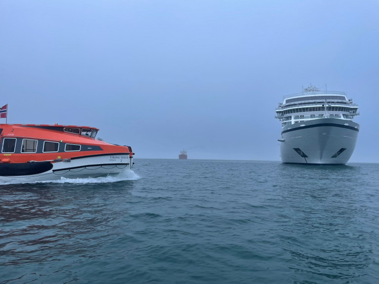
The first cruiseship in Irish waters since Covid19 restrictions were put in place more than two years ago but removed earlier this month, has led Viking Venus to visit Dun Laoghaire Harbour with an anchorage call this morning, writes Jehan Ashmore.
Afloat last night tracked Viking Venus in the Celtic Sea having departed from Dover. The Kent port forming a destination as part of a 14-day cruise that started from London (Tilbury) and terminates next month in Bergen, Norway. The cruise will include calling to Holyhead, other UK ports and the Shetland Islands.
At around 0630hrs a pilot boarded the 47,842 gross tonnage cruiseship in a foggy Dublin Bay so to enable an anchorage position to take place off Dun Laoghaire Harbour. The port operator, Dun Laoghaire-Rathdown County Council (DLRCC) expects more of these anchorage 'tender' calls in the region of 60 to be made this season.
Cruisegoers have been taken ashore by tenders and welcomed alongside Carlisle Pier. At the quayside, marquees are in place along with coach excursion providers awaiting those from the 930-passenger cruise ship. This follows the removal of strict Covid19 travel protocal restrictions from those travelling to Ireland which the Department of Health revoked on 6 March.
 Cruise goers are taken ashore by tenders and welcomed alongside the Carlisle Pier with awaiting coaches Photo: Afloat
The decision also applied to ferry passengers, has led to the reopening of the cruise sector that overall is worth €70m to the Irish economy. The development follows high levels of vaccination take up in Ireland, coupled with predictions of a strong recovery in the tourism sector this summer.
The season's inaugural call to Dun Laoghaire Harbour of the cruiseship, is operated by Viking Cruises with an operational office based in Basel, Switzerland. The company marks their 25th anniversary this year having begun its origins from running river-cruises in Europe.
As for cruisegoers on board Viking Venus, it is understood the majority of guests are mostly American and having paid USD $6,999 based on double occupancy rates on the cruiseship which was only built in April of last year by Fincantieri’s shipyard in Ancona, Italy.
A private veranda comes with every stateroom, while as for dining is concerned there is a choice of restaurants offering a variety of culinary options. For fitness and leisurely pursuits, there's an infinity pool, a Nordic-inspired spa, a two-deck Explorers’ Lounge with panoramic views. Those liking to reading, there are thoughtfuly curated book collections spead throughout the cruiseship.
As alluded above tenders from the 221m long cruiseship have ferried cruisegoers ashore to Dun Laoghaire's Carlisle Pier where a pontoon is provided to facilitate passengers with easier access. It is at the same pier where much smaller sized such ships have used this berth to disembark passengers.
The next scheduled 'in port' caller Afloat identified to be the Greg Mortimer which DLRCC has confirmed and also to arrive in mid-May.
On occasional calls over the years, they have included turn-around cruises. This has involved fly-cruises using Dublin with tourists transferred to and from Dun Laoghaire, where one set of passengers disembark to be followed on the same day with those embarking the cruiseship's gangway.


 Michael Murphy Schull Harbour Sailing Club (SHSC), Eric Coogan Heineken Ireland, Mark Murphy, Commodore SHSC, Jack Allen SHSC, Carmel O'Regan SHSC, Cornelious Ndlovu, Schull Harbour Hotel Operations Manager and Derval Murphy SHSC")

