Menu

Ireland's sailing, boating & maritime magazine

Inland afloat headers


Displaying items by tag: Francis Joyon

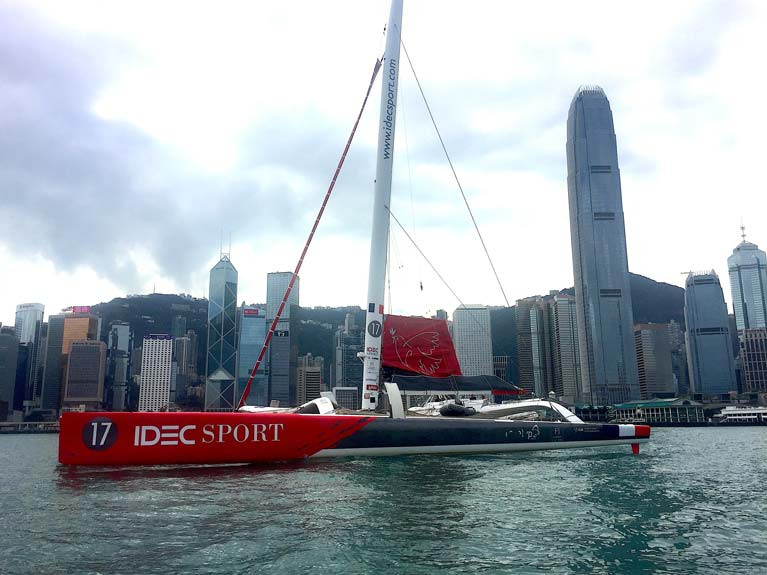
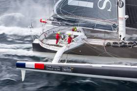
Francis Joyon will begin the final Act of the IDEC SPORT ASIAN TOUR at around 0900hrs UTC on Saturday morning with an attempt at the Tea Route record.

On this legendary route between Hong Kong and London, the reference time has been held since 2018 by the Italian, Giovanni Soldini. Once again with his small crew of four, including the boat captain Bertrand Delesne, the assistants and crewmen, Antoine Blouet and Corentin Joyon and his faithful friend, Christophe Houdet, Francis will be sailing on the route he sailed to get to the Far East at the end of last year, but this time in the opposite direction and without stopping. During his outward voyage, he set a new record for the Mauritius Route between Brittany and Mauritius and two new reference times for the trips between Mauritius and Ho Chi Minh City (Vietnam), and then between Vietnam and Shenzhen in China. His latest goal is to complete the voyage back to Europe in a time below that set by the 70-foot trimaran, Maserati and Giovanni Soldini’s crew of 36 days, 2 hours and 37 minutes, when they averaged 17.4 knots.

Following the route taken by the big clippers of the past

“We left Shenzhen yesterday for Hong Kong and the starting area for the record.” Francis is not planning to hang around and intends to set sail on Saturday morning at around 0900hrs UTC. By then, he will have carried out the final adjustments aboard the boat, tightening the tension of the mast and loading up the supplies for the long sprint that lies ahead of around 13,000 theoretical miles. “We have done our utmost in conditions that were not that simple to check the condition of the boat,” added Francis. “The crew is really enthusiastic about this so full of history, symbolising the trade between the British Empire and China. We shall indeed be bringing some tea back to London, as the big clippers of the past used to do. This time it will be organic tea from a fair trade source, as that was something that was important for Christophe Houdet.”

Risk of a cyclone in the Indian Ocean and suspense in the Atlantic

The route is largely characterised by the trade winds that the IDEC SPORT maxi trimaran is looking forward to. “We shall be setting off in some decent conditions,” explained Francis. “They are nothing special, but it does mean sailing downwind in the NE’ly trade winds as we head towards the Sunda Strait and the awesome calms that punished us so much on the way out here. It looks like it is going to be particularly calm around the Equator. Once into the Indian Ocean, there is the risk of a cyclone, where we could face average winds of 35 knots, but we will continue to sail downwind.” Sailing the vast distances in the South and North Atlantic will, as usual, mean dealing with the large Saint Helena high-pressure system in the South and the Azores high in the North, before we make our way right up the English Channel towards the Thames Estuary. “This Tea Route is really the big one for us in our epic adventure,” added the skipper of IDEC SPORT. “Christian Dumard, our weather advisor, expects to see us reach the Cape of Good Hope within the record time. So, there should be a lot of suspense on the climb back up the Atlantic.”

Published in Offshore
Tagged under

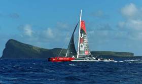
The skipper of the IDEC SPORT maxi-trimaran shattered the Mauritius offshore Route record between Port Louis (Brittany) and Port Louis (Mauritius) at 0726hrs local time (0326hrs UTC) on Friday 8th November).

Francis Joyon smashed the reference time he set in November 2009 by more than six days and brings the Mauritius Route record down to less than 20 days or to be more precise to 19 days, 18 hours, 14 mins and 45 seconds.

The Mauritius Route record is the first act in the new campaign of ocean records, the IDEC SPORT ASIAN TOUR, which the skipper of the IDEC SPORT maxi-trimaran is currently tackling.

Published in Offshore
Tagged under

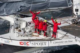
The Maxi Trimaran IDEC SPORT sailed by Francis Joyon, Clément Surtel, Alex Pella, Bernard Stamm, Gwénolé Gahinet and Sébastien Audigane won the Jules Verne Trophy, the outright round the world sailing record, this morning.

They crossed the finish at 0749hrs UTC on Thursday 26th January 2017.

Francis Joyon and his crew sailed the 22,461 theoretical miles in 40 days, 23 hours, 30 minutes and 30 seconds, at an average speed of 22.84 knots.

Out on the water, they actually sailed 26,412 miles at an average speed of 26.85 knots.

They shattered the previous record set by Loïck Peyron and the crew of the maxi trimaran Banque Populaire V by 4 days, 14 hours, 12 minutes and 23 seconds.

During this round the world voyage, they smashed no fewer than six intermediate records at Cape Leeuwin, off Tasmania, on the International Date Line, at Cape Horn, at the Equator and off Ushant.

Published in Offshore
Tagged under

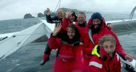
The IDEC SPORT maxi-trimaran skippered by Francis Joyon crossed the longitude of Cape Horn, the last of the three major capes in the Jules Verne trophy at 0004 UTC on Thursday 12th January. After leaving Ushant on 16th December, Joyon and his crew of five, Clément Surtel, Sébastien Audigane, Bernard Stamm, Gwénolé Gahinet and Alex Pella have achieved the best intermediate time between Ushant and Cape Horn, completing this stretch in 26 days, 15 hours, 45 minutes some 4 days 6 hours and 35 minutes ahead of the reference time set by Banque Populaire V in 2012 (30 days, 22 hours and 19 minutes).

This is their fourth intermediate record including the Pacific Ocean record between the SE of Tasmania and Cape Horn with a time of 7 days 21 hours and 14 minutes (record held by Bruno Peyron since 2005 with a time of 8 days, 18 hours and 8 minutes).

IDEC-SPORT sailed the 18,332 miles out on the water between Ushant and Cape Horn at an average speed of 28.7 knots.

Jules Verne Trophy reference time / Banque Populaire V (2012): 45 days, 13 hours, 42 minutes and 53 seconds

Published in Offshore
Tagged under

The IDEC SPORT maxi-trimaran has just gone to code green, meaning that their departure is imminent. They are about to make another attempt at the outright crewed round the world record, the Jules Verne Trophy.

Francis Joyon and his crew comprising Clément Surtel, Alex Pella, Bernard Stamm, Gwénolé Gahinet and Sébastien Audigane are back in Brest, where they are carrying out the final preparations and stowing supplies on the boat.

The Jules Verne Trophy is awarded to the skipper who breaks the outright record, starting from an imaginary line between the Créac'h lighthouse on Ouessant (Ushant) Island, France, and the Lizard Lighthouse, UK. The current holder is Banque Populaire V skippered by Loick Peyron in 45 days 13 hours 42 minutes 53 seconds. 

Joyon's crew completed a circumnavigation earlier this year in a time of 47 days 14 hours 47 minutes and did not break the record.

A window of opportunity has arisen with a start possible in the mid-morning on Thursday from Ushant. It should give them a good time to the Equator, as long as they manage to deal well with the first 36 hours, which look rough off Brittany. Francis Joyon is giving himself a few more hours to think about it before deciding whether to cast off tomorrow or not.

The latest sea state observations and forecasts for the near Atlantic and the weather systems expected in the South Atlantic are being analysed by Marcel van Triest. The Dutch router will provide his final analysis this evening to enable Francis and his crew to take the ultimate decision about whether to set sail shortly or wait until later in the week for the seas to ease.


Published in Jules Verne Trophy

The massive French trimaran IDEC SPORT has hit an unidentified floating object during the night, 130 miles off the southwest coast of Ireland. The port rudder is broken. However they are still expected to reach the pontoon in Brest at 1900hrs UTC after its failed Jules Verne Trophy attempt.

At around 0300hrs this morning, just over 130 miles SW of Ireland in heavy seas, the crew on IDEC SPORT heard two big bangs, indicating that they had hit an unidentified floating object (a container, plank of wood, or something else?).

Once they had got over the scare, Francis Joyon’s crew saw that the port rudder was broken. On the starboard tack, only the central rudder can be used to steer the boat. Six hours after suffering this damage, IDEC SPORT was still making 30 knots towards the finish, which at 0900hrs this morning was 230 miles away. So for the time being the men are still expected to finish in Brest at around 1900hrs this evening.

Published in Offshore

The French sailor, Francis Joyon is due to set off early today (Tuesday 11th June) to tackle the solo Atlantic crossing aboard his maxi trimaran IDEC. He is expected to cross the official starting line at the foot of Ambrose Light off New York between 0000hrs and 0600hrs GMT (0200hrs – 0800hrs CET). He will be facing the Atlantic alone all the way to the Lizard at the southernmost tip of Cornwall and is hoping to complete the voyage in less than 5 days, 19 hours, 30 minutes and 40 seconds in order to have his name added to the registers of the World Speed Sailing Record Council in place of the current holder, Thomas Coville. Francis Joyon would achieve two success in one, if he does this. He will be regaining a title that was his until 2008, and above all will become the only man to hold the four most important solo sailing records, the Round the World Record, the 24-hour distance record, the Columbus Route record and the North Atlantic record.

A decent weather opportunity
"The weather opportunity tonight is looking decent," according to Jean-Yves Bernot, the leading light in ocean racing navigation, who continues to assists Francis Joyon is his major sailing challenges. To put it simply, the conditions are looking favourable, if not ideal, but are decent enough to allow him to make this attempt. Back in France, the two men had been watching a low-pressure area develop over the continent of North America, offering the strength and trajectory that suits this record, which over the years has become increasingly difficult to beat. During the weekend, Francis Joyon was more and more certain of the situation and decided to climb aboard a plane yesterday to head for New York, where he will get back with his giant trimaran IDEC, currently moored in Gateway Marina in Brooklyn, New York.

A possible start at between midnight and six (GMT)
The hulls will be cleaned, the final supplies stowed aboard, and as usual, everything will be done all by himself. Joyon will run through the final details about the weather situation tonight with Jean-Yves Bernot, before setting off on the perilous journey to the starting line and the former site of the legendary Ambrose Light at the entrance to the bay off New York. The light itself was removed in 2008 after a series of collisions, and has now been replaced by a set of lit buoys. If he sets off between midnight and six (GMT), he will be able to make the most of the daylight to cover the tricky miles sailing his boat up out of the river. The low that is passing over Labrador should allow him to sail along in steady thirty-knot winds blowing from the east-south-east on seas that should be easy to deal with for at least the first two-thirds of the course. As is often the case in these record attempts, it is the final phase, as they approach the British Isles, which are the most uncertain. The winds are likely to strengthen towards the end of the week, making it more complicated for the solo sailor. However, with the low moving along fairly high up to the north, it should allow IDEC to stay close to the direct route, and therefore get the best trajectory towards the Channel approaches, and sail along efficiently towards the Lizard.

New York – The Lizard, 2880 theoretical nautical miles (or 5334 km).

Solo North Atlantic records
1987: Bruno Peyron, Explorer catamaran, in 11 days, 11 hours 46 minutes and 36 seconds
1990: Florence Arthaud, Pierre 1er trimaran, in 9 days, 21 hours and 42 minutes
1992: Bruno Peyron, Explorer catamaran, in 9 days, 19 hours and 22 minutes
1994: Laurent Bourgnon, Primagaz trimaran, in 7 days, 2 hours, 34 minutes and 42 seconds
2005: Francis Joyon, IDEC 1 trimaran, in 6 days, 4 hours, 1 minute and 37 seconds
2008: Thomas Coville, Sodebo trimaran, in 5 days, 19 hours, 29 minutes and 20 seconds

The three major solo records already held by Francis Joyon aboard IDEC
2008: Solo Round the World record in 57 days, 13 hours 34 minutes and 06 seconds
2012: Distance sailed in 24h: 666 miles at an average speed of 27.75 knots
2013: Columbus Route Cadiz-San Salvador: 8 days 16 h 07 minutes and 05 seconds.

Published in Solo Sailing

General Information on using Waterways Ireland inland navigations

Safety on the Water

All users of the navigations are strongly recommended to make themselves aware of safety on the water for whatever activity they are involved in and to read the advice offered by the various governing bodies and by:

The Dept. of Transport, Ireland: www.gov.ie/transport and The Maritime and Coastguard Agency, UK, The RNLI – Water Safety Ireland for information in terms of drowning prevention and water safety.

Registration of Vessels

All vessels using the Shannon Navigation, which includes the Shannon-Erne Waterways and the Erne System must be registered with Waterways Ireland. Only open undecked boats with an engine of 15 horsepower or less on the Shannon Navigation, and vessels of 10 horsepower or less on the Erne System, are exempt. Registration is free of charge.

Craft registration should be completed online at: https://www.waterwaysireland.org/online-services/craft-registration

Permits for use of the Grand and Royal Canals and the Barrow Navigation

All vessels using the Grand and Royal Canals and the Barrow Navigation must display appropriate valid Permit(s) i.e A Combined Mooring and Passage Permit (€126) and if not intending to move every five days, an Extended Mooring Permit (€152).

Permit applications should be completed online at: https://www.waterwaysireland.org/online-services/canal-permits

Passage on the Royal and Grand Canals – Dublin Area

For boat passage through the locks east of Lock 12 into / out of Dublin on either the Royal or Grand Canals, Masters are requested to contact the Waterways Ireland Eastern Regional Office (M-F 9.30am-4.30pm) on tel: +353(0)1 868 0148 or email [email protected] prior to making passage in order to plan the necessary lock-keeping assistance arrangements.

On the Grand Canal a minimum of two days notice prior to the planned passage should be given, masters should note that with the exception of pre-arranged events, a maximum of 2 boats per day will be taken through the locks, travelling either east or west.

Movements in or out of the city will be organised by prior arrangement to take place as a single movement in one day. Boaters will be facilitated to travel the system if their passage is considered to be safe by Waterways Ireland and they have the valid permit(s) for mooring and passage.

Newcomen Lifting Bridge

On the Royal Canal two weeks’ notice of bridge passage (Newcomen Lifting Bridge) is required for the pre-set lift date, and lock assistance will then also be arranged. A minimum of 2 boats is required for a bridge lift to go ahead.

Waterways Ireland Eastern Regional Office (Tel: +353(0)1 868 0148 or [email protected] ) is the point of contact for the bridge lift.

A maximum number of boats passing will be implemented to keep to the times given above for the planned lifts (16 for the Sat / Sun lifts & 8 for the weekday lifts). Priority will be given on a first come first served basis.

On day of lift, boaters and passengers must follow guidance from Waterways Ireland staff about sequence of passage under bridge & through Lock 1, and must remain within signed and designated areas.

Events Held on the Waterways

All organised events taking place on the waterways must have the prior approval of Waterways Ireland. This is a twelve week process and application forms must be accompanied with the appropriate insurance, signed indemnity and risk assessment. The application should be completed on the Waterways Ireland events page at :

https://www.waterwaysireland.org/online-services/event-approval

Time Limits on Mooring in Public Harbours

On the Shannon Navigation and the Shannon-Erne Waterway craft may berth in public harbours for five consecutive days or a total of seven days in any one month.

On the Erne System, revised Bye Laws state that: No master or owner shall permit a vessel, boat or any floating or sunken object to remain moored at or in the vicinity of any public mooring, including mooring at any other public mooring within 3 kilometres of that location, for more than 3 consecutive days and shall not moor at that same mooring or any other public mooring within 3 kilometres of that location within the following 3 consecutive days without prior permission by an authorised official.

Winter Mooring on the Shannon Navigation and Shannon Erne Waterway

Winter mooring may be availed of by owners during the period 1 Nov to 31 Mar by prior arrangement and payment of a charge of €63.50 per craft. Craft not availing of Winter Mooring must continue to comply with the “5 Day Rule”. Winter Mooring applications should be completed online at : https://www.waterwaysireland.org/online-services/winter-moorings-booking

Owners should be aware that electricity supply and water supply to public moorings is disconnected for the winter months. This is to protect against frost damage, to reduce running costs and to minimise maintenance requirements during the winter months.

Vessel owners are advised that advance purchasing of electricity on the power bollards leading up to the disconnection date should be minimal. Electricity credit existing on the bollards will not be recoverable after the winter decommissioning date. Both services will be reinstated prior to the commencement of the next boating season.

Smart Cards

Waterways Ireland smart cards are used to operate locks on the Shannon Erne Waterway, to access the service blocks, to use the pump-outs along the navigations, to avail of electrical power at Waterways Ireland jetties.

Berthing in Public Harbours

Masters are reminded of the following:

  • Equip their vessel with mooring lines of appropriate length and strength and only secure their craft to mooring bollards and cleats provided for this purpose.
  • Ensure the available berth is suitable to the length of your vessel, do not overhang the mooring especially on finger moorings on floating pontoon moorings.
  • Ensure mooring lines, electric cables and fresh water hoses do not create a trip hazard on public jetties for others users.
  • Carry sufficient fenders to prevent damage to your own vessel, other vessels and WI property.
  • Allow sufficient space between your vessel and the vessel ahead /astern (c.1m) for fire safety purposes and /or to recover somebody from the water.
  • Do not berth more than two vessels side by side and ensure there is safe access/egress at all times between vessels and onto the harbour itself.
  • Do not berth in such a way to prevent use of harbour safety ladders, slipways or pump-outs.
  • Do not allow the bow of your vessel to overhang the walkway of a floating mooring thus creating a hazard for others with an overhanging anchor or bow fendering.
  • Animals are not allowed to be loose or stray at any time.
  • Harbour and jetty infrastructure such as railings, power pedestals, fresh water taps, electric light poles, safety bollards, ladders etc are not designed for the purpose of mooring craft , they will not bear the strain of a vessel and will be damaged.
  • At Carrybridge on the Erne System, Masters of vessels are not permitted to use stern on mooring. Masters of vessels must use the mooring fingers for mooring of vessels and for embarkation / disembarkation from vessels.

Passenger Vessel Berths

Masters of vessels should not berth on passenger vessel berths where it is indicated that an arrival is imminent. Passenger vessels plying the navigations generally only occupy the berths to embark and disembark passengers and rarely remain on the berths for extended periods or overnight.

Lock Lead-in Jetties

Lead-in jetties adjacent to the upstream and downstream gates at lock chambers are solely for the purpose of craft waiting to use the lock and should not be used for long term berthing.

Vessel Wake

Vessel wake, that is, the wave generated by the passage of the boat through the water, can sometimes be large, powerful and destructive depending on the hull shape and engine power of the vessel. This wake can be detrimental to other users of the navigation when it strikes their craft or inundates the shoreline or riverbank. Masters are requested to frequently look behind and check the effect of their wake / wash particularly when passing moored vessels, on entering harbours and approaching jetties and to be aware of people pursuing other activities such as fishing on the riverbank.

Speed Restriction

A vessel or boat shall not be navigated on the Shannon Navigation at a speed in excess of 5 kph when within 200 metres of a bridge, quay, jetty or wharf, when in a harbour or canal or when passing within 100 metres of a moored vessel or boat.

Vessels navigating the Shannon-Erne Waterway should observe the general 5 kph speed limit which applies along the waterway. This is necessary in order to prevent damage to the banks caused by excessive wash from vessels.

Vessels navigating the Erne System should observe the statutory 5kt / 6mph / 10kph speed limit areas.

A craft on the Royal and Grand canals shall not be navigated at a speed in excess of 6km per hour.

A craft on the Barrow Navigation shall not be navigated at a speed in excess of 11km per hour except as necessary for safe navigation in conditions of fast flow.

Bank Erosion

Narrow sections of all the navigations are particularly prone to bank erosion due to the large wash generated by some craft. Masters are requested to be vigilant and to slow down to a speed sufficient to maintain steerage when they observe the wash of their craft inundating the river banks.

Unusual Waterborne Activity

Unusual waterborne vessels may be encountered from time to time, such as, hovercraft or amphibious aircraft / seaplanes. Masters of such craft are reminded to apply the normal “Rule of the Road” when they meet conventional craft on the water and to allow extra room to manoeuvre in the interest of safety.

Sailing Activity

Mariners will encounter large numbers of sailing dinghies from late June to August in the vicinity of Lough Derg, Lough Ree and Lower Lough Erne. Sailing courses are marked by yellow buoys to suit weather conditions on the day. Vessels should proceed at slow speed and with due caution and observe the rules of navigation when passing these fleets, as many of the participants are junior sailors under training.

Rowing

Mariners should expect to meet canoes and vessels under oars on any part of the navigations, but more so in the vicinity of Athlone, Carrick-on-Shannon, Coleraine, Enniskillen and Limerick. Masters are reminded to proceed at slow speed and especially to reduce their wash to a minimum when passing these craft as they can be easily upset and swamped due to their very low freeboard and always be prepared to give way in any given traffic situation.

Canoeing

Canoeing is an adventure sport and participants are strongly recommended to seek the advice of the sport’s governing bodies i.e Canoeing Ireland and the Canoe Association of Northern Ireland, before venturing onto the navigations.

Persons in charge of canoes are reminded of the inherent danger to these craft associated with operating close to weirs, sluice gates, locks and other infrastructure particularly when rivers are in flood and large volumes of water are moving through the navigations due to general flood conditions or very heavy localised precipitation e.g. turbulent and broken water, stopper waves. Shooting weirs is prohibited without prior permission of Waterways Ireland.

Canoeists should check with lockkeepers prior entering a lock to ensure passage is done in a safe manner. Portage is required at all unmanned locks.

Canoe Trail Network – "Blueways"

Masters of powered craft are reminded that a canoe trail network is being developed across all navigations and to expect more organised canoeing along these trails necessitating slow speed and minimum wash when encountering canoeists, rowing boats etc

Rockingham and Drummans Island Canals – Lough Key

It is expected that work on Rockingham and Drummans Island Canals on Lough Key will be completed in 2021. Access to these canals will be for non-powered craft only, eg canoes, kayaks, rowing boats.

Fast Powerboats and Personal Watercraft (Jet Skis)

Masters of Fast Powerboats (speed greater than 17kts) and Personal Watercraft (i.e.Jet Skis) are reminded of the inherent dangers associated with high speed on the water and especially in the confines of small bays and narrow sections of the navigations. Keeping a proper look-out, making early alterations to course and /or reducing speed will avoid conflict with slower vessels using the navigation. Personal Watercraft are not permitted to be used on the canals.

Towing Waterskiers, Wakeboarders, Doughnuts etc

Masters of vessels engaged in any of these activities are reminded of the manoeuvring constraints imposed upon their vessel by the tow and of the added responsibilities that they have to the person(s) being towed. These activities should be conducted in areas which are clear of conflicting traffic. It is highly recommended that a person additional to the master be carried to act as a “look-out” to keep the tow under observation at all times.

Prohibition on Swimming

Swimming in the navigable channel, particularly at bridges, is dangerous and is prohibited due to the risk of being run over by a vessel underway in the navigation.

Age Restrictions on operating of powered craft

In the Republic of Ireland, Statutory Instrument 921 of 2005 provides the legal requirements regarding the minimum age for operating of powered craft. The Statutory Instrument contains the following requirements:

- The master or owner of a personal watercraft or a fast power craft shall take all reasonable steps to ensure that a person who has not attained the age of 16 years does not operate or control the craft

- The master or owner of a pleasure craft powered by an engine with a rating of more than 5 horse power or 3.7 kilowatts shall take all reasonable steps to ensure that a person who has not attained the age of 12 years does not operate or control the craft.

Lifejackets and Personal Flotation Devices (PFDs)

Lifejackets and PFD’s are the single most important items of personal protective equipment to be used on a vessel and should be worn especially when the vessel is being manoeuvred such as entering / departing a lock, anchoring, coming alongside or departing a jetty or quayside.

In the Republic of Ireland, Statutory Instrument 921 of 2005 provides the legal requirements regarding the wearing of Personal Flotation Devices. The Statutory Instrument contains the following requirements:

- The master or owner of a pleasure craft (other than a personal watercraft) shall ensure, that there are, at all times on board the craft, sufficient suitable personal flotation devices for each person on board.

- A person on a pleasure craft (other than a personal watercraft) of less than 7 metres length overall shall wear a suitable personal flotation device while on board an open craft or while on the deck of decked craft, other than when the craft is made fast to the shore or at anchor.

- The master or owner of a pleasure craft (other than a personal watercraft) shall take all reasonable steps to ensure that a person who has not attained the age of 16 years complies with paragraph above.

- The master or owner of a pleasure craft (other than a personal watercraft), shall take all reasonable steps to ensure that a person who has not attained the age of 16 years wears a suitable personal flotation device while on board an open craft or while on the deck of a decked craft other than when it is made fast to the shore or at anchor.

- The master or owner of a pleasure craft (other than a personal watercraft) shall take all reasonable steps to ensure that a person wears a suitable personal flotation device, at all times while – (a) being towed by the craft, (b) on board a vessel or object of any kind which is being towed by the craft.

Further information is available at: http://www.irishstatutebook.ie/eli/2005/si/921/made/en/print

Firing Range Danger Area – Lough Ree

The attention of mariners is drawn to the Irish Defence Forces Firing Range situated in the vicinity of buoys No’s 2 and 3, on Lough Ree on the Shannon Navigation. This range is used regularly for live firing exercises, throughout the year, all boats and vessels should stay clear of the area marked with yellow buoys showing a yellow "X" topmark and displaying the word "Danger".

Shannon Navigation, Portumna Swing Bridge Tolls

No attempt should be made by Masters’ of vessels to pay the bridge toll while making way through the bridge opening. Payment will only be taken by the Collector from Masters when they are secured alongside the jetties north and south of the bridge.

Navigating from Killaloe to Limerick on the Shannon Navigation

The navigation from Killaloe to Limerick involves passage through Ardnacrusha locks, the associated headrace and tailrace and the Abbey River into Limerick City. Careful passage planning is required to undertake this voyage. Considerations include: lock passage at Ardnacrusha, water flow in the navigation, airdraft under bridges on Abbey River in Limerick, state of tide in Limerick

Users are advised to contact the ESB Ardnacrusha hydroelectric power station (00353 (0)87 9970131) 48 hours in advance of commencing their journey to book passage through the locks at Ardnacrusha. It is NOT advised to undertake a voyage if more than one turbine is operating (20MW), due to the increased velocity of flow in the navigation channel, which can be dangerous. To ascertain automatically in real time how many turbines are running, users can phone +353 (0)87 6477229.

For safety reasons the ESB has advised that only powered craft with a capacity in excess of 5 knots are allowed to enter Ardnacrusha Headrace and Tailrace Canals.

Passage through Sarsfield Lock should be booked on +353-87-7972998, on the day prior to travel and it should be noted also that transit is not possible two hours either side of low water.

A Hydrographic survey in 2020 of the navigation channel revealed that the approach from Shannon Bridge to Sarsfield Lock and the Dock area has silted up. Masters of vessels and water users are advised to navigate to the Lock from Shannon bridge on a rising tide one or two hours before High Tide.

Lower Bann Navigation

The attention of all users is drawn to the “Users Code for the Lower Bann”, in particular to that section covering “Flow in the River” outlining the dangers for users both on the banks and in the navigation, associated with high flow rates when the river is in spate. Canoeists should consult and carry a copy of the “Lower Bann Canoe Trail” guide issued by the Canoe Association of Northern Ireland. Users should also contact the DfI Rivers Coleraine, who is responsible for regulating the flow rates on the river, for advisory information on the flow rates to be expected on any given day.

DfI Rivers Coleraine. Tel: 0044 28 7034 2357 Email: [email protected]

Lower Bann Navigation – Newferry – No wake zone

A No Wake Zone exists on the Lower Bann Navigation at Newferry. Masters of vessels are requested to proceed at a slow speed and create no wake while passing the jetties and slipways at Newferry.

Overhead Power Lines (OHPL) and Air draft

All Masters must be aware of the dangers associated with overhead power lines, in particular sailing vessels and workboats with cranes or large air drafts. Voyage planning is a necessity in order to identify the location of overhead lines crossing the navigation.

Overhead power line heights on the River Shannon are maintained at 12.6metres (40 feet) from Normal Summer level for that section of navigation, masters of vessels with a large air draft should proceed with caution and make additional allowances when water levels are high.

If a vessel or its equipment comes into contact with an OHPL the operator should NOT attempt to move the vessel or equipment. The conductor may still be alive or re-energise automatically. Maintain a safe distance and prevent third parties from approaching due to risk of arcing. Contact the emergency services for assistance.

Anglers are also reminded that a minimum ground distance of 30 metres should be maintained from overhead power lines when using a rod and line.

Submarine Cables and Pipes

Masters of vessels are reminded not to anchor their vessels in the vicinity of submarine cables or pipes in case they foul their anchor or damage the cables or pipes. Look to the river banks for signage indicating their presence.

Water Levels - Precautions

Low Water Levels:

When water levels fall below normal summer levels masters should be aware of:

Navigation

To reduce the risk of grounding masters should navigate on or near the centreline of the channel, avoid short cutting in dog-legged channels and navigating too close to navigation markers.

Proceeding at a slow speed will also reduce “squat” effect i.e. where the vessel tends to sit lower in the water as a consequence of higher speed.

Slipways

Reduced slipway length available under the water surface and the possibility of launching trailers dropping off the end of the concrete apron.

More slipway surface susceptible to weed growth requiring care while engaged in launching boats, from slipping and sliding on the slope. Note also that launching vehicles may not be able to get sufficient traction on the slipway once the craft is launched to get up the incline.

Bank Erosion

Very dry riverbanks are more susceptible to erosion from vessel wash.

Lock Share

Maximising on the number of vessels in a lock will ensure that the total volume of water moving downstream is decreased. Lock cycles should be used for vessels travelling each way.

High Water Levels:

When water levels rise above normal summer level masters should be aware of:

Navigation

Navigation marks will have reduced height above the water level or may disappear underwater altogether making the navigable channel difficult to discern.

In narrow sections of the navigations water levels will tend to rise more quickly than in main streams and air draft at bridges will likewise be reduced.

There will also be increased flow rates particularly in the vicinity of navigation infrastructure such as bridges, weirs, locks etc where extra care in manoeuvring vessels will be required.

Harbours and Jetties

Due care is required in harbours and at slipways when levels are at or near the same level as the harbour walkways' as the edge will be difficult to discern especially in reduced light conditions. It is advised that Personal Flotation Devices be worn if tending to craft in a harbour in these conditions.

Slipways

Slipways should only be used for the purpose of launching and recovering of water craft or other objects from the water. Before using a slipway it should be examined to ensure that the surface has sufficient traction/grip for the intended purpose such as launching a craft from a trailer using a vehicle, that there is sufficient depth of water on the slipway to float the craft off the trailer before the concrete apron ends and that the wheels of the trailer do not drop off the edge of the slipway. That life-saving appliances are available in the vicinity, that the vehicle is roadworthy and capable of coping with the weight of the trailer and boat on the incline. It is recommended that slipway operations are conducted by two persons.

Caution to be Used in Reliance upon Aids to Navigation

The aids to navigation depicted on the navigation guides comprise a system of fixed and floating aids to navigation. Prudent mariners will not rely solely on any single aid to navigation, particularly a floating aid to navigation. With respect to buoys, the buoy symbol is used to indicate the approximate position of the buoy body and the ground tackle which secures it to the lake or river bed. The approximate position is used because of the practical limitations in positioning and maintaining buoys in precise geographical locations. These limitations include, but are not limited to, prevailing atmospheric and lake/river conditions, the slope of and the material making up the lake/river bed, the fact that the buoys are moored to varying lengths of chain, and the fact that the buoy body and/or ground tackle positions are not under continuous surveillance. Due to the forces of nature, the position of the buoy body can be expected to shift inside and outside the charted symbol.

Buoys and perches are also moved out of position or pulled over by those mariners who use them to moor up to instead of anchoring. To this end, mariners should always monitor their passage by relating buoy/perch positions with the published navigation guide. Furthermore, a vessel attempting to pass close by always risks collision with a yawing buoy or with the obstruction that the buoy or beacon/perch marks.

Masters of Vessels are requested to use the most up to date Navigation guides when navigating on the Inland Waterways.

Information taken from Special Marine Notice No 1 of 2023