Menu

Ireland's sailing, boating & maritime magazine

Inland afloat headers


Displaying items by tag: Harry McLoughlin

#marinetourism – Yet another Failte Ireland Marine Research initiative is taking shape to examine the coastal infrastructure for leisure sailors of all kinds, and how facilities might be developed to attract visitors from abroad, while better serving the home fleets. In view of this new research programme, W M Nixon returns to the topic of Dunmore East's potential for development, and sets it in the national context.

Every port in Ireland should be so lucky as to have someone like Harry McLoughlin as Harbour Master. Down in Dunmore East, he's passionate about fulfilling the potential of his picturesque harbour. And it's no easy task, as Dunmore is trying to cope with meeting the demands of a growing home port fishing fleet, while the numbers seeking berths can fluctuate rapidly with visiting boats.

At the same time, the peak summer months will see leisure craft arrive in unpredictable numbers, keen to avail of any sheltered berthing to be had in a port whose strategic usefulness will be obvious to anyone with experience of cruising the Irish coast. And on top of that, from time to time cruise liners will call by, anchoring off and seeking to disembark passengers via their ship's tenders in this characterful little port, where virtually every inch of quayside and pontoon space is already taken by a wide variety of boats.

This provides a colourful and crowded scene, which makes it even more attractive for visitors who might be jaded by the usual big port/cruise liner berthing routine. But it's a headache for a harbour master who has to juggle the often conflicting requirements of different boat interests.

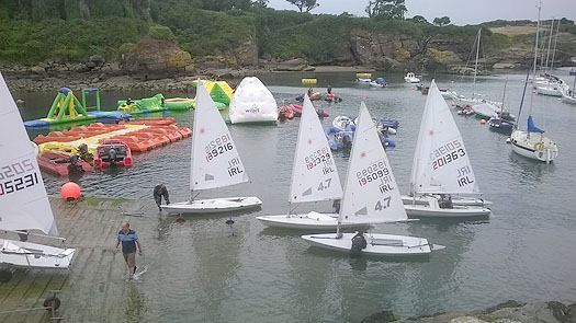
Last week's series of photos gave a snapshot of a few moments in a Dunmore East summer afternoon which well illustrate the challenges that Harry McLoughlin constantly faces. The reality is that the new industrial-style 40 metre pontoon along the East Pier under the lighthouse is a multi-purpose facility. Certainly it has been installed with leisure visitors in mind. But thanks to the welcome growth in the Dunmore East fishing fleet in the last couple of years, there are times when the dedicated pontoons for smaller fishing craft in the southwest corner of the harbour become impossibly crowded. The main quays have to be left clear for large trawlers unloading their catches and their other berthing requirements. So when there's so much pressure on space, some smaller fishing boats are sent across to the Visitors' Pontoon if it happens to be clear, and no visitor is expected.

dunmore_east_visitor2.jpg
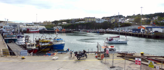
No room at the inn.......an unannounced and unexpected cruising boat finds no space available when pressure is on the berthing at the small craft pontoon. Photo: W M Nixon

It has to be confessed, though, that some of us when cruising are oddly reluctant to call ahead to the Harbour Office when approaching a new port. We prefer just to come in round the pierhead, hoping to be able to choose our own favoured berth without any communication with officialdom at all. It's part of the attraction of cruising when you can do this, as it adds to the sense of freedom which commanding your own small boat is supposed to confer. But the reality is that in a place like Dunmore East, you just have to call ahead, and that is what last week's photos, in the final analysis, seem to be all about.

dunmore_east_visitor3.jpg
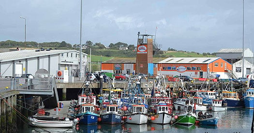
When they pack them in at Dunmore East, they do it big time. A notably trim fleet of smaller craft crowded at their own pontoon. Photo: Aileen Egan

dunmore_east_visitor4.jpg
The big boys are in town. Quay space has to be kept available at all times for the comings and goings of larger trawlers. Photo: Harry McLoughlin

But with so much pressure on space, how can Dunmore also cope with the special demands of cruise liner passengers – many of them far from the first flush of youth – disembarking from ship's tenders? Well, in the spirit of community which keeps Dunmore going, the secret is the cruise liner passengers are allowed to come ashore on the usually hallowed territory of the RNLI pontoon.

dunmore_east_visitor4a.jpg

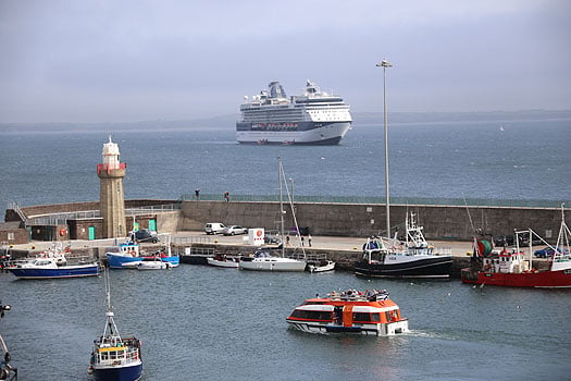
An example of a port harnessing different activities and working together with yachts, trawlers and, in the foreground, cruise line passengers disembarking at Dunmore East. Photo: David O'Brien

dunmore_east_visitor5.jpg

The extended slipway at Dunmore East, which has an abundance of younger sailors who would benefit greatly from an improved harbour. Photo: Harry McLoughlin

That such a temporary re-allocation of resources is necessary from time to time reinforces the genuine demand for improved facilities at many of Ireland's key ports. It will be interesting to see how the priorities are high-lighted by the international research programme which is being implemented under a new Failte Ireland initiative, with an advisory panel of Norman Kean, who researches and edits the Irish Cruising Club Sailing Directions for both the book and on-line versions, Paal Janson the General Manager of Dun Laoghaire Marina, representing the Irish Marine Federation, and Gail MacAllister of the ISA.

We could be forgiven for being a bit bewildered about some of this. Exactly seventeen months ago, in this blog on Saturday April 13th 2013, we were welcoming an up-coming report for Failte Ireland, titled: A Review of Tourism Policy Regarding the Funding of Marina and Berthing Facilities in Ireland. Ultimately known as the Fisher Report and resulting from the work of an agency from outside Ireland, it has since been gathering dust on some shelf. Now, that dust has apparently congealed into aspic with the realisation that the report was so vague and general that it didn't provide any sufficiently clearcut conclusions and proposals to form the basis of a policy.

The questionnaires which are being developed will be targeted at Irish, British, French and German markets. Making a point of ensuring that Irish leisure sailors are included in the equation strikes me as essential, for not only are we often sailing visitors in our own country, as our island's coastlines are long enough and sufficiently varied to make this the case, but visitors from abroad are attracted by the vibrant Irish sailing scene. Thus anything which provides better facilities for our own sailors will be beneficial in a much wider context.

The guidance of someone as experienced in cruising as Norman Kean will be invaluable, as the framing of the questions is vital in producing a worthwhile result. Then too, Norman is at the heart of the Irish sailing and boating scene, both with his key role in the internationally-praised Cruising Club Sailing Directions, and the fact that he is based at Courtmacsherry in West Cork, a friendly port which has shown it knows a thing or two about how to make visiting cruising boats feel welcome, and wish to come back again.

So we can be sure that the doughty Norman will accurately and eloquently represent the views and requirements of the Irish boating community, whose enthusiastic approach to sailing in all its forms is an important part of the package for boating visitors. This is all-too-frequently overlooked by the powers-that-be, who are so keen to tot up numbers of new visitors that they overlook the existence and needs of Ireland's large home sailing community, all of whom are more than willing to be personal hospitality managers when visiting boats come to call.

But in any case, regarding the ultimate value of market research, we should remind ourselves of Henry Ford's opinion on it, as we did back on April 13th 2013. The great car pioneer and manufacturer said that when starting out in business, if he'd asked his potential customers what they wanted, they'd have demanded a faster horse...

It seems that with the Fisher Report, we didn't even get a slow horse, we got a lame duck. So for the moment, instead of setting up a ponderous set of questions, Afloat.ie will simply dream on. What do we want for good cruising in Ireland? Well, setting aside those who insist that a giant astrodome should be installed to cover the entire country before they'll come near the place, we have a wish list that begins with good sailing which is sometimes sufficiently challenging to make the completion of each passage a satisfying experience. And all of it to be done with a background of attractive coastal scenery.

As for making safe passages, and then getting the best from each haven at the end, we'll know that the Irish Cruising Club Sailing Directions are an indispensable guide. Ideally, we'll be in an area with an abundance of natural anchorages where we can put down our own anchor without fear of fouling abandoned moorings or other detritus on the seabed. If there are reliable and regularly-serviced visitors moorings, that's fine and welcome too. But we who cruise the Irish coast, and the western seaboard in particular, do so in the knowledge that any proper cruising vessel will have her own more-than-adequate ground tackle.

If we happen to be sailing along an Irish coastline which lacks an abundance of natural harbours, we would like handy artificial harbours – preferably with marinas – at about 35 mile intervals or even less, as 35 nautical miles seems to be the magic distance which is easily attainable in one day, yet its completion really does make you feel you've moved on.

This sense of needing to move on is part of what cruising is all about. It satisfies some hidden genetic urge which most of the time is dormant in us, but given half a chance, there is indeed a gypsy in our soul. However, having satisfied our wanderlust by the modest total of 35 or so miles made good, what will we expect to find ashore?

Your complete dyed-in-the-wool cruising person is often content simply to stay on board enjoying the natural grace which is provided by a boat lying comfortably to her own anchor. Be sure, though, to choose a spot where your pride-and-joy won't be uncomfortably tide-rode, which so often turns out to be the case in what looked to be a snug if narrow inlet.

In their wellnigh perfect anchorage, these traditional cruising folk will be happy to dine aboard. At such times, you realise that a good sea cook is a pearl beyond price, much more valuable – in this age of sensitive auto-helms – than a top helmsman for the general welfare of the crew and the success of the cruise.

dunmore_east_visitor6.jpg
Mayo SC's landing pontoon at Rosmoney on Clew Bay is an impressive piece of work. Photo: W M Nixon

dunmore_east_visitor7.jpg
The attractive facilities at Mayo SC bring in a membership from all over North Connacht. Photo: W M Nixon

Such traditional cruising people, if they do go ashore, are quite happy to scramble up some awkward foreshore for a bracing hike on nearby moorland, or even climb a mountain or two. But the vast majority of us – and an increasing majority as newcomers arrive in cruising – prefer to get easily ashore from an anchored boat via the dinghy onto a good jetty, and ideally a landing pontoon - such as you see at civilised places like Mayo Sailing Club on Clew Bay – is both much safer, and more convenient.

However, let's face it, when cruising you're on your holidays. After a perhaps slightly rugged day at sea, there's no doubting the benefits conferred by a comfortable marina berth. Apart from the safety and security, there's the simple sense of freedom. While there are those who enjoy the restricted and aromatic confines of a cruising yacht, for many it can quickly become claustrophobic, and the freedom of personal movement which a marina confers on the cruising crew can be vital for preserving harmony. And it greatly broadening the options of what to do once ashore, because unlike the crew from an anchored boat reliant on one dinghy, crews in marinas can come and go as they please.

Perhaps it's the fact that they have this choice is one of the reasons why, by and large, cruising crews tend to stay as a group when they are ashore – they may even be celebrating the fact that they're still friends, and a marina can help in this.

As to what's needed ashore, basically it's good hospitality facilities within easy walking distance. The "easy walking" requirement cannot be over-emphasised. Once you're into a cruise, you're moving at a different speed in a different frame of mind, and too much walking on tarmac or cobblestones or whatever becomes simply tiresome. In fact, you'll have noticed that some experienced cruising folk are surprisingly willing to take a taxi if there's anything other than a short walk involved. For they also know that, coming off a boat, you're out of sync with road traffic – a cruising crew ambling along a busy road can be a hazard to themselves and a distracting menace for other road users.

So we're beginning to get the picture of our cruising crew's Irish dream port. It has to be colourful, characterful, and compact. Ideally, all facilities for every possible need, including repair, fuelling and re-storing, should be within easy reach from a marina berth with full-sized walkways and proper pontoons – you might be a bit rocky on your pins after a rough day at sea, and sea legs need something better than a cogglesome thin little finger pontoon.

From all this, it is clear that Kinsale is the Irish cruising port par excellence, even if the Yacht Club marina does get over-crowded betimes, and even if, when the ebb is running hard and there's a strong sou'easter blowing, the boats rafted along the outer berths have a bumpy time of it. Despite all this, Kinsale has so much to offer we can learn from it, and from other top cruising visitor places like Dingle and Howth while the new harbour at Greystones on the Wicklow coast is a fascinating example of a port in active transition from a small boat mini-haven to a proper harbour with marina and full facilities for multiple uses.

But equally there has to be fresh thinking about making the best of existing ports. In other words, the old notion that some ports should be exclusively designated as Fisheries Harbours is patently nonsense when those harbours are located in key positions with ready-made characterful port towns and villages as part of the package.

There still is some residual resistance in a few ports to the very notion of a marina being installed. But it should be seen in the broader context as an indicator of attractive peace and prosperity, every bit as much as a facility for visiting boaters who will be keen to spend their holiday money ashore. I was recently in Ballycastle in the far northeast corner of Ireland, and in going up the town we noticed a welcome air of prosperity. Buildings had been painted and generally spruced up. This was even more marked in the area down beside the little harbour, where there's a small but very useful marina, and the regular ferry leaves from its much-improved berth for Rathlin Island six miles away. We still think of it as the "new harbour and marina" at Ballycastle, although it has been around for some time now. But such facilities are put in for the long haul, and it is now that Ballycastle harbour's attractive sense of purpose and prosperity has had this beneficial spinoff for the mood of the town.

dunmore_east_visitor8.jpgThe small but convenient and very useful marina at Ballycastle has played a part in the North Antrim town's improved perception of itself. Photo Kevin Dwyer courtesy Irish Cruising Club

Elsewhere in the north, one of our favourite ports is Ardglass, where one of the most strategically useful marinas on the entire Irish coast was slotted into a spare corner of what had formerly been a decidedly rugged "fishing-and-fishing-only" place, and the mood has been pleasantly lightened as a result.

dunmore_east_visitor9.jpg
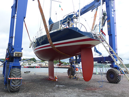
A handsome and obviously fast perfomance cruiser in the hoist at an Irish port – but where is it? Photo: W M Nixon

But for pure rugged essence of total fishing port, you just couldn't beat the Wild West atmosphere of Killybegs in Donegal. The fishing has been mighty, and there are now at least 23 multi-millionaires in the Killybegs area whose wealth has been drawn from the sea. Yet in recent years, the Killybegs attitude has softened slightly. The place has tidied itself up, and as one of the best natural harbor in the entire northwest of Ireland, it has put out some visitors' mooring for leisure craft, while serious cruising men visiting this challenging but rewarding area find that the Mooney Boats quayside yard with its massive travel hoist is a real boon.

Killybegs does have space where a marina could be installed to be handy to the town while not interfering with fishing boat needs, and judging by the quality boats flying foreign ensigns on the visitors moorings, its usefulness as a crew-change port is a particular asset, as the international airport at Knock isn't so very
far away.

dunmore_east_visitor10.jpg
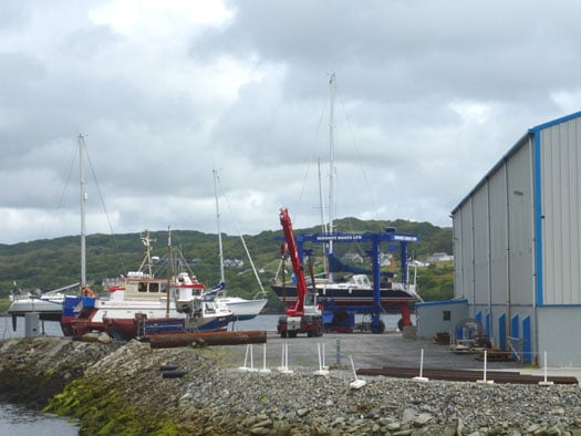
Killybegs is the answer, with Mooney Boats a boon for boat visitors to Donegal. Photo: W M Nixon

dunmore_east_visitor11.jpg
Once upon a time, Killybegs was fishing, just fishing, and only fishing. But now the deep sea trawlers are well used to sharing their harbour with visiting yachts, in this case a couple of Dutch boats. Photo: W M Nixon

So if Killybegs can take aboard the idea of a marina, maybe the other mega-fishing-port of Castetownbere in southwest Ireland can do so too. That said, there is a hugely popular little marina already well established at the other end of Bere Island at Lawrence Cove, but a convenient facility at the western end of Bere Haven would improve cruising options.

dunmore_east_visitor12.jpg
The 78ft cruiser-racer Whisper contrasts vividly with the lifeboat in Castletownbere, a fishing port which might be able to find space for a marina. Photo: W M Nixon

In the cruising heartlands of West Cork, we can expect new movement on the long-proposed marina at Schull, which would greatly help in rationalizing pier use. But in bustling Baltimore there may be more of a challenge in creating a proper marina, as waterfront space beside the village is limited. As it is, the current berthing pontoon which juts straight out into the harbour can be a mixed blessing when there's a serious wind from the west, with the pitching and banging of boats and pontoon sections being a nuisance at best, and a real hazard at its worst.

dunmore_east_visitor13.jpg
The berthing pontoon at Baltimore can become a decidedly exposed place when the wind is fresh from the west.

But all these places already have something of a range of choices, in Dunmore East there's just this one little bit of a harbour, and everyone wants a piece of it. I make no excuses for dragging out the dog-eared rough sketch of what a marina might look like if there was to be a realistic separation of fishing and leisure use, for while we do suggest that places which were originally exclusively fishing ports can be usefully modified to be partially leisure ports as well, there's no doubting the primary need of clearly defined boundaries between the two within the harbour confines.

dunmore_east_visitor14.jpg
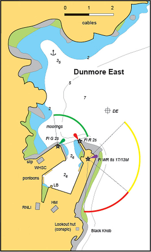
Dunmore East as it is today, and surely ripe for development

dunmore_east_visitor15.jpg
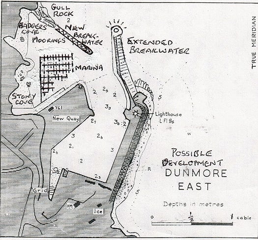
The possibilities for a marina at Dunmore East are suggested in this rough sketch

For there's no doubt we all wish the very best for Dunmore East. It very much wants to be a hospitable port, and can do it very well too, given half a chance. Harry McLoughlin was talking enthusiastically about some of the fine boats and great sailing people he has welcomed since he took over as Dunmore's Harbour Master in the Spring of 2013, and from 2014 he best remembers the great Jim Mottram.

Jim cruises alone in his pretty little Elizabethan 23 Reservation out of Christchurch in Dorset just outside the west entrance to the Solent, and over the decades he has logged some formidable voyages, down to Spain, and round Britain three times. But as his boat has a lifting keel which reduces the draft to 2ft 6ins, for 2014 he decided that a cruise to Ireland with a spell on the inland waterways would make for a change.

dunmore_east_visitor16.jpg

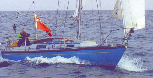
The most senior sailor – Dunmore East visitor Jim Mottram has cruised thousands of miles in his Elizabethan 23 Reservation.

So he arrived into Dunmore East early in the season, intending to go up the Barrow, across Ireland on the Grand Canal, then back to the sea again via the Shannon through Limerick. But after going up to Waterford from Dunmore, he reckoned the early-season surge down the River Barrow would make things unnecessarily difficult, so he cruised right round the south coast of Ireland and went up the Shannon Estuary to Limerick. There, he unstepped his mast, and motored north through Lough Derg and into the Grand Canal at Shannon Harbour, then right across Ireland to swoosh down the Barrow – which becomes even more lovely the further south you go – until in New Ross the manager of the Three Sisters Marina John Diamond set him up again, and on he went down to Dunmore East for a warm welcome and a celebration of his near-circuit of Munster.

Harry McLoughlin discovered Jim had a special birthday coming up while he was in Dunmore East, so he and his wife took the lone skipper along to the Waterford Harbour Sailing Club for a party to celebrate both the birthday and the success of his cruising since he'd last been with them.

And which birthday was Jim Mottram celebrating?

His 80th, of course.

Published in W M Nixon

General Information on using Waterways Ireland inland navigations

Safety on the Water

All users of the navigations are strongly recommended to make themselves aware of safety on the water for whatever activity they are involved in and to read the advice offered by the various governing bodies and by:

The Dept. of Transport, Ireland: www.gov.ie/transport and The Maritime and Coastguard Agency, UK, The RNLI – Water Safety Ireland for information in terms of drowning prevention and water safety.

Registration of Vessels

All vessels using the Shannon Navigation, which includes the Shannon-Erne Waterways and the Erne System must be registered with Waterways Ireland. Only open undecked boats with an engine of 15 horsepower or less on the Shannon Navigation, and vessels of 10 horsepower or less on the Erne System, are exempt. Registration is free of charge.

Craft registration should be completed online at: https://www.waterwaysireland.org/online-services/craft-registration

Permits for use of the Grand and Royal Canals and the Barrow Navigation

All vessels using the Grand and Royal Canals and the Barrow Navigation must display appropriate valid Permit(s) i.e A Combined Mooring and Passage Permit (€126) and if not intending to move every five days, an Extended Mooring Permit (€152).

Permit applications should be completed online at: https://www.waterwaysireland.org/online-services/canal-permits

Passage on the Royal and Grand Canals – Dublin Area

For boat passage through the locks east of Lock 12 into / out of Dublin on either the Royal or Grand Canals, Masters are requested to contact the Waterways Ireland Eastern Regional Office (M-F 9.30am-4.30pm) on tel: +353(0)1 868 0148 or email [email protected] prior to making passage in order to plan the necessary lock-keeping assistance arrangements.

On the Grand Canal a minimum of two days notice prior to the planned passage should be given, masters should note that with the exception of pre-arranged events, a maximum of 2 boats per day will be taken through the locks, travelling either east or west.

Movements in or out of the city will be organised by prior arrangement to take place as a single movement in one day. Boaters will be facilitated to travel the system if their passage is considered to be safe by Waterways Ireland and they have the valid permit(s) for mooring and passage.

Newcomen Lifting Bridge

On the Royal Canal two weeks’ notice of bridge passage (Newcomen Lifting Bridge) is required for the pre-set lift date, and lock assistance will then also be arranged. A minimum of 2 boats is required for a bridge lift to go ahead.

Waterways Ireland Eastern Regional Office (Tel: +353(0)1 868 0148 or [email protected] ) is the point of contact for the bridge lift.

A maximum number of boats passing will be implemented to keep to the times given above for the planned lifts (16 for the Sat / Sun lifts & 8 for the weekday lifts). Priority will be given on a first come first served basis.

On day of lift, boaters and passengers must follow guidance from Waterways Ireland staff about sequence of passage under bridge & through Lock 1, and must remain within signed and designated areas.

Events Held on the Waterways

All organised events taking place on the waterways must have the prior approval of Waterways Ireland. This is a twelve week process and application forms must be accompanied with the appropriate insurance, signed indemnity and risk assessment. The application should be completed on the Waterways Ireland events page at :

https://www.waterwaysireland.org/online-services/event-approval

Time Limits on Mooring in Public Harbours

On the Shannon Navigation and the Shannon-Erne Waterway craft may berth in public harbours for five consecutive days or a total of seven days in any one month.

On the Erne System, revised Bye Laws state that: No master or owner shall permit a vessel, boat or any floating or sunken object to remain moored at or in the vicinity of any public mooring, including mooring at any other public mooring within 3 kilometres of that location, for more than 3 consecutive days and shall not moor at that same mooring or any other public mooring within 3 kilometres of that location within the following 3 consecutive days without prior permission by an authorised official.

Winter Mooring on the Shannon Navigation and Shannon Erne Waterway

Winter mooring may be availed of by owners during the period 1 Nov to 31 Mar by prior arrangement and payment of a charge of €63.50 per craft. Craft not availing of Winter Mooring must continue to comply with the “5 Day Rule”. Winter Mooring applications should be completed online at : https://www.waterwaysireland.org/online-services/winter-moorings-booking

Owners should be aware that electricity supply and water supply to public moorings is disconnected for the winter months. This is to protect against frost damage, to reduce running costs and to minimise maintenance requirements during the winter months.

Vessel owners are advised that advance purchasing of electricity on the power bollards leading up to the disconnection date should be minimal. Electricity credit existing on the bollards will not be recoverable after the winter decommissioning date. Both services will be reinstated prior to the commencement of the next boating season.

Smart Cards

Waterways Ireland smart cards are used to operate locks on the Shannon Erne Waterway, to access the service blocks, to use the pump-outs along the navigations, to avail of electrical power at Waterways Ireland jetties.

Berthing in Public Harbours

Masters are reminded of the following:

  • Equip their vessel with mooring lines of appropriate length and strength and only secure their craft to mooring bollards and cleats provided for this purpose.
  • Ensure the available berth is suitable to the length of your vessel, do not overhang the mooring especially on finger moorings on floating pontoon moorings.
  • Ensure mooring lines, electric cables and fresh water hoses do not create a trip hazard on public jetties for others users.
  • Carry sufficient fenders to prevent damage to your own vessel, other vessels and WI property.
  • Allow sufficient space between your vessel and the vessel ahead /astern (c.1m) for fire safety purposes and /or to recover somebody from the water.
  • Do not berth more than two vessels side by side and ensure there is safe access/egress at all times between vessels and onto the harbour itself.
  • Do not berth in such a way to prevent use of harbour safety ladders, slipways or pump-outs.
  • Do not allow the bow of your vessel to overhang the walkway of a floating mooring thus creating a hazard for others with an overhanging anchor or bow fendering.
  • Animals are not allowed to be loose or stray at any time.
  • Harbour and jetty infrastructure such as railings, power pedestals, fresh water taps, electric light poles, safety bollards, ladders etc are not designed for the purpose of mooring craft , they will not bear the strain of a vessel and will be damaged.
  • At Carrybridge on the Erne System, Masters of vessels are not permitted to use stern on mooring. Masters of vessels must use the mooring fingers for mooring of vessels and for embarkation / disembarkation from vessels.

Passenger Vessel Berths

Masters of vessels should not berth on passenger vessel berths where it is indicated that an arrival is imminent. Passenger vessels plying the navigations generally only occupy the berths to embark and disembark passengers and rarely remain on the berths for extended periods or overnight.

Lock Lead-in Jetties

Lead-in jetties adjacent to the upstream and downstream gates at lock chambers are solely for the purpose of craft waiting to use the lock and should not be used for long term berthing.

Vessel Wake

Vessel wake, that is, the wave generated by the passage of the boat through the water, can sometimes be large, powerful and destructive depending on the hull shape and engine power of the vessel. This wake can be detrimental to other users of the navigation when it strikes their craft or inundates the shoreline or riverbank. Masters are requested to frequently look behind and check the effect of their wake / wash particularly when passing moored vessels, on entering harbours and approaching jetties and to be aware of people pursuing other activities such as fishing on the riverbank.

Speed Restriction

A vessel or boat shall not be navigated on the Shannon Navigation at a speed in excess of 5 kph when within 200 metres of a bridge, quay, jetty or wharf, when in a harbour or canal or when passing within 100 metres of a moored vessel or boat.

Vessels navigating the Shannon-Erne Waterway should observe the general 5 kph speed limit which applies along the waterway. This is necessary in order to prevent damage to the banks caused by excessive wash from vessels.

Vessels navigating the Erne System should observe the statutory 5kt / 6mph / 10kph speed limit areas.

A craft on the Royal and Grand canals shall not be navigated at a speed in excess of 6km per hour.

A craft on the Barrow Navigation shall not be navigated at a speed in excess of 11km per hour except as necessary for safe navigation in conditions of fast flow.

Bank Erosion

Narrow sections of all the navigations are particularly prone to bank erosion due to the large wash generated by some craft. Masters are requested to be vigilant and to slow down to a speed sufficient to maintain steerage when they observe the wash of their craft inundating the river banks.

Unusual Waterborne Activity

Unusual waterborne vessels may be encountered from time to time, such as, hovercraft or amphibious aircraft / seaplanes. Masters of such craft are reminded to apply the normal “Rule of the Road” when they meet conventional craft on the water and to allow extra room to manoeuvre in the interest of safety.

Sailing Activity

Mariners will encounter large numbers of sailing dinghies from late June to August in the vicinity of Lough Derg, Lough Ree and Lower Lough Erne. Sailing courses are marked by yellow buoys to suit weather conditions on the day. Vessels should proceed at slow speed and with due caution and observe the rules of navigation when passing these fleets, as many of the participants are junior sailors under training.

Rowing

Mariners should expect to meet canoes and vessels under oars on any part of the navigations, but more so in the vicinity of Athlone, Carrick-on-Shannon, Coleraine, Enniskillen and Limerick. Masters are reminded to proceed at slow speed and especially to reduce their wash to a minimum when passing these craft as they can be easily upset and swamped due to their very low freeboard and always be prepared to give way in any given traffic situation.

Canoeing

Canoeing is an adventure sport and participants are strongly recommended to seek the advice of the sport’s governing bodies i.e Canoeing Ireland and the Canoe Association of Northern Ireland, before venturing onto the navigations.

Persons in charge of canoes are reminded of the inherent danger to these craft associated with operating close to weirs, sluice gates, locks and other infrastructure particularly when rivers are in flood and large volumes of water are moving through the navigations due to general flood conditions or very heavy localised precipitation e.g. turbulent and broken water, stopper waves. Shooting weirs is prohibited without prior permission of Waterways Ireland.

Canoeists should check with lockkeepers prior entering a lock to ensure passage is done in a safe manner. Portage is required at all unmanned locks.

Canoe Trail Network – "Blueways"

Masters of powered craft are reminded that a canoe trail network is being developed across all navigations and to expect more organised canoeing along these trails necessitating slow speed and minimum wash when encountering canoeists, rowing boats etc

Rockingham and Drummans Island Canals – Lough Key

It is expected that work on Rockingham and Drummans Island Canals on Lough Key will be completed in 2021. Access to these canals will be for non-powered craft only, eg canoes, kayaks, rowing boats.

Fast Powerboats and Personal Watercraft (Jet Skis)

Masters of Fast Powerboats (speed greater than 17kts) and Personal Watercraft (i.e.Jet Skis) are reminded of the inherent dangers associated with high speed on the water and especially in the confines of small bays and narrow sections of the navigations. Keeping a proper look-out, making early alterations to course and /or reducing speed will avoid conflict with slower vessels using the navigation. Personal Watercraft are not permitted to be used on the canals.

Towing Waterskiers, Wakeboarders, Doughnuts etc

Masters of vessels engaged in any of these activities are reminded of the manoeuvring constraints imposed upon their vessel by the tow and of the added responsibilities that they have to the person(s) being towed. These activities should be conducted in areas which are clear of conflicting traffic. It is highly recommended that a person additional to the master be carried to act as a “look-out” to keep the tow under observation at all times.

Prohibition on Swimming

Swimming in the navigable channel, particularly at bridges, is dangerous and is prohibited due to the risk of being run over by a vessel underway in the navigation.

Age Restrictions on operating of powered craft

In the Republic of Ireland, Statutory Instrument 921 of 2005 provides the legal requirements regarding the minimum age for operating of powered craft. The Statutory Instrument contains the following requirements:

- The master or owner of a personal watercraft or a fast power craft shall take all reasonable steps to ensure that a person who has not attained the age of 16 years does not operate or control the craft

- The master or owner of a pleasure craft powered by an engine with a rating of more than 5 horse power or 3.7 kilowatts shall take all reasonable steps to ensure that a person who has not attained the age of 12 years does not operate or control the craft.

Lifejackets and Personal Flotation Devices (PFDs)

Lifejackets and PFD’s are the single most important items of personal protective equipment to be used on a vessel and should be worn especially when the vessel is being manoeuvred such as entering / departing a lock, anchoring, coming alongside or departing a jetty or quayside.

In the Republic of Ireland, Statutory Instrument 921 of 2005 provides the legal requirements regarding the wearing of Personal Flotation Devices. The Statutory Instrument contains the following requirements:

- The master or owner of a pleasure craft (other than a personal watercraft) shall ensure, that there are, at all times on board the craft, sufficient suitable personal flotation devices for each person on board.

- A person on a pleasure craft (other than a personal watercraft) of less than 7 metres length overall shall wear a suitable personal flotation device while on board an open craft or while on the deck of decked craft, other than when the craft is made fast to the shore or at anchor.

- The master or owner of a pleasure craft (other than a personal watercraft) shall take all reasonable steps to ensure that a person who has not attained the age of 16 years complies with paragraph above.

- The master or owner of a pleasure craft (other than a personal watercraft), shall take all reasonable steps to ensure that a person who has not attained the age of 16 years wears a suitable personal flotation device while on board an open craft or while on the deck of a decked craft other than when it is made fast to the shore or at anchor.

- The master or owner of a pleasure craft (other than a personal watercraft) shall take all reasonable steps to ensure that a person wears a suitable personal flotation device, at all times while – (a) being towed by the craft, (b) on board a vessel or object of any kind which is being towed by the craft.

Further information is available at: http://www.irishstatutebook.ie/eli/2005/si/921/made/en/print

Firing Range Danger Area – Lough Ree

The attention of mariners is drawn to the Irish Defence Forces Firing Range situated in the vicinity of buoys No’s 2 and 3, on Lough Ree on the Shannon Navigation. This range is used regularly for live firing exercises, throughout the year, all boats and vessels should stay clear of the area marked with yellow buoys showing a yellow "X" topmark and displaying the word "Danger".

Shannon Navigation, Portumna Swing Bridge Tolls

No attempt should be made by Masters’ of vessels to pay the bridge toll while making way through the bridge opening. Payment will only be taken by the Collector from Masters when they are secured alongside the jetties north and south of the bridge.

Navigating from Killaloe to Limerick on the Shannon Navigation

The navigation from Killaloe to Limerick involves passage through Ardnacrusha locks, the associated headrace and tailrace and the Abbey River into Limerick City. Careful passage planning is required to undertake this voyage. Considerations include: lock passage at Ardnacrusha, water flow in the navigation, airdraft under bridges on Abbey River in Limerick, state of tide in Limerick

Users are advised to contact the ESB Ardnacrusha hydroelectric power station (00353 (0)87 9970131) 48 hours in advance of commencing their journey to book passage through the locks at Ardnacrusha. It is NOT advised to undertake a voyage if more than one turbine is operating (20MW), due to the increased velocity of flow in the navigation channel, which can be dangerous. To ascertain automatically in real time how many turbines are running, users can phone +353 (0)87 6477229.

For safety reasons the ESB has advised that only powered craft with a capacity in excess of 5 knots are allowed to enter Ardnacrusha Headrace and Tailrace Canals.

Passage through Sarsfield Lock should be booked on +353-87-7972998, on the day prior to travel and it should be noted also that transit is not possible two hours either side of low water.

A Hydrographic survey in 2020 of the navigation channel revealed that the approach from Shannon Bridge to Sarsfield Lock and the Dock area has silted up. Masters of vessels and water users are advised to navigate to the Lock from Shannon bridge on a rising tide one or two hours before High Tide.

Lower Bann Navigation

The attention of all users is drawn to the “Users Code for the Lower Bann”, in particular to that section covering “Flow in the River” outlining the dangers for users both on the banks and in the navigation, associated with high flow rates when the river is in spate. Canoeists should consult and carry a copy of the “Lower Bann Canoe Trail” guide issued by the Canoe Association of Northern Ireland. Users should also contact the DfI Rivers Coleraine, who is responsible for regulating the flow rates on the river, for advisory information on the flow rates to be expected on any given day.

DfI Rivers Coleraine. Tel: 0044 28 7034 2357 Email: [email protected]

Lower Bann Navigation – Newferry – No wake zone

A No Wake Zone exists on the Lower Bann Navigation at Newferry. Masters of vessels are requested to proceed at a slow speed and create no wake while passing the jetties and slipways at Newferry.

Overhead Power Lines (OHPL) and Air draft

All Masters must be aware of the dangers associated with overhead power lines, in particular sailing vessels and workboats with cranes or large air drafts. Voyage planning is a necessity in order to identify the location of overhead lines crossing the navigation.

Overhead power line heights on the River Shannon are maintained at 12.6metres (40 feet) from Normal Summer level for that section of navigation, masters of vessels with a large air draft should proceed with caution and make additional allowances when water levels are high.

If a vessel or its equipment comes into contact with an OHPL the operator should NOT attempt to move the vessel or equipment. The conductor may still be alive or re-energise automatically. Maintain a safe distance and prevent third parties from approaching due to risk of arcing. Contact the emergency services for assistance.

Anglers are also reminded that a minimum ground distance of 30 metres should be maintained from overhead power lines when using a rod and line.

Submarine Cables and Pipes

Masters of vessels are reminded not to anchor their vessels in the vicinity of submarine cables or pipes in case they foul their anchor or damage the cables or pipes. Look to the river banks for signage indicating their presence.

Water Levels - Precautions

Low Water Levels:

When water levels fall below normal summer levels masters should be aware of:

Navigation

To reduce the risk of grounding masters should navigate on or near the centreline of the channel, avoid short cutting in dog-legged channels and navigating too close to navigation markers.

Proceeding at a slow speed will also reduce “squat” effect i.e. where the vessel tends to sit lower in the water as a consequence of higher speed.

Slipways

Reduced slipway length available under the water surface and the possibility of launching trailers dropping off the end of the concrete apron.

More slipway surface susceptible to weed growth requiring care while engaged in launching boats, from slipping and sliding on the slope. Note also that launching vehicles may not be able to get sufficient traction on the slipway once the craft is launched to get up the incline.

Bank Erosion

Very dry riverbanks are more susceptible to erosion from vessel wash.

Lock Share

Maximising on the number of vessels in a lock will ensure that the total volume of water moving downstream is decreased. Lock cycles should be used for vessels travelling each way.

High Water Levels:

When water levels rise above normal summer level masters should be aware of:

Navigation

Navigation marks will have reduced height above the water level or may disappear underwater altogether making the navigable channel difficult to discern.

In narrow sections of the navigations water levels will tend to rise more quickly than in main streams and air draft at bridges will likewise be reduced.

There will also be increased flow rates particularly in the vicinity of navigation infrastructure such as bridges, weirs, locks etc where extra care in manoeuvring vessels will be required.

Harbours and Jetties

Due care is required in harbours and at slipways when levels are at or near the same level as the harbour walkways' as the edge will be difficult to discern especially in reduced light conditions. It is advised that Personal Flotation Devices be worn if tending to craft in a harbour in these conditions.

Slipways

Slipways should only be used for the purpose of launching and recovering of water craft or other objects from the water. Before using a slipway it should be examined to ensure that the surface has sufficient traction/grip for the intended purpose such as launching a craft from a trailer using a vehicle, that there is sufficient depth of water on the slipway to float the craft off the trailer before the concrete apron ends and that the wheels of the trailer do not drop off the edge of the slipway. That life-saving appliances are available in the vicinity, that the vehicle is roadworthy and capable of coping with the weight of the trailer and boat on the incline. It is recommended that slipway operations are conducted by two persons.

Caution to be Used in Reliance upon Aids to Navigation

The aids to navigation depicted on the navigation guides comprise a system of fixed and floating aids to navigation. Prudent mariners will not rely solely on any single aid to navigation, particularly a floating aid to navigation. With respect to buoys, the buoy symbol is used to indicate the approximate position of the buoy body and the ground tackle which secures it to the lake or river bed. The approximate position is used because of the practical limitations in positioning and maintaining buoys in precise geographical locations. These limitations include, but are not limited to, prevailing atmospheric and lake/river conditions, the slope of and the material making up the lake/river bed, the fact that the buoys are moored to varying lengths of chain, and the fact that the buoy body and/or ground tackle positions are not under continuous surveillance. Due to the forces of nature, the position of the buoy body can be expected to shift inside and outside the charted symbol.

Buoys and perches are also moved out of position or pulled over by those mariners who use them to moor up to instead of anchoring. To this end, mariners should always monitor their passage by relating buoy/perch positions with the published navigation guide. Furthermore, a vessel attempting to pass close by always risks collision with a yawing buoy or with the obstruction that the buoy or beacon/perch marks.

Masters of Vessels are requested to use the most up to date Navigation guides when navigating on the Inland Waterways.

Information taken from Special Marine Notice No 1 of 2023