Menu

Ireland's sailing, boating & maritime magazine

Inland afloat headers


Displaying items by tag: Lancer

#Unmanned - School children in South Carolina in the USA are awaiting news on the whereabouts of their unmanned sailboat that made landfall in Ireland's North West this past week.

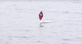
As WCSC Live 5 News reports, the miniature vessel named Cruiser was believed to be on its way to a school in Bangor Erris after reaching the Co Mayo mainland near Achill Island on Wednesday (11 October), some five months after it was launched by students at Harbor View Elementary in Charleston.

If you have any information as to Cruiser’s current whereabouts, you can get in touch with the school HERE.

The news comes six months after the miniature unmanned yacht Lancer was returned to the ocean after sailing from the north east US to Connemara — and bringing together the Connecticut high schooler behind the marine science project with the Galway girl who found the boat near her home.

In July, Lancer was tracked on a return course to Ireland. The boat finally made landfall near Plymouth in Devon last month, but its current whereabouts are unknown.

Published in Marine Science
Tagged under

#Lancer - The unmanned miniature yacht Lancer is heading back to Ireland – and may make landfall in Kerry or Cork within weeks.

The 1.5m boat made the news when it was found washed ashore in Connemara by local girl Méabh Ní Ghionnáin in September 2016 after a four-month transatlantic crossing from Cape Cod, where it was launched on behalf of Connecticut high schooler Kaitlyn Dow.

Before Kaitlyn and Méabh met earlier the year, Lancer was restored to working order by local sea scouts, and was relaunched from the Marine Institute’s marine science vessel RV Celtic Explorer on 22 April in the middle of the Atlantic Ocean.

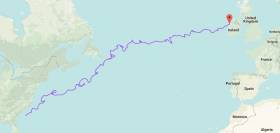
Three months on, the latest tracking info shows that instead of catching currents that would have taken it either north towards Greenland or south to the Canaries, the mini yacht has found its way back into Irish waters — currently south-west of the Scilly Isles in the Celtic Sea.

The red GPS tracking line shows an interesting pattern in its movements across the ocean over the last three-plus months. The blue line, meanwhile, shows the original path of Lancer when it was launched from the US last year. 

The white line shows a low-tech drifter that Kaitlyn Dow built as part of the NOAA drifters programme but was unfortunately lost at sea.

Marine Institute chief executive Dr Peter Heffernan said he was delighted that Lancer had made its way back ‘home’.

“This little boat is proving to be a great vessel promoting awareness about our ocean,” he said. :With the Atlantic being the second largest ocean in the world, it is important to increase our awareness of the value, opportunities and societal benefits the ocean provides us. 

“With the Lancer currently positioned over the continental shelf, if it keeps heading towards the south-west coast we hope that it lands safely and provides another group of people the opportunity to meet and learn more about our ocean currents and winds of our seas.”

Lancer is one of a number of mini sailboats launched as part of an Atlantic Ocean Research Alliance (AORA) ocean literacy partnership to raise awareness of the Atlantic among coastal communities, and our reciprocal impact.

“If people can get the word out that the boat is approaching, maybe someone will see her,” urged Michael O’Connor, Kaitlyn Dow’s science teacher at Waterford High School.

“Instructions on what to do with the Lancer boat are inside.”

Published in Marine Science
Tagged under

#Lancer - The Marine Institute has posted video of the successful launch of the unmanned yacht Lancer in the Atlantic this past weekend.

The miniature marine research vessel was released from the RV Celtic Explorer on Saturday 22 April in the middle of the Atlantic, in the hopes of it catching either the Irminger current (to take it north towards Greenland) or the Canary current (to carry it southwards towards Africa).

According to the most recent fix via the online GPS tracker, Lancer indeed appears to be headed north to continue its mission.

As previously reported on Afloat.ie, the boat was seen off from Galway by Méabh Ní Ghionnáin, who found the vessel beached near her home in Connemara last September.

The eight-year-old since met with Kaitlyn Dow, the Connecticut high schooler who launched the vessel as part of a year-long science project studying ocean winds and currents.

Published in Marine Science
Tagged under

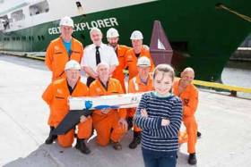
Méabh Ní Ghionnáin from Droim, Leitir Móir, Galway met with the Marine Institute’s scientists and crew on the RV Celtic Explorer today on her 9th birthday (18th April) to see the loading of the 1 ½ metre Lancer unmanned sailboat onto the research vessel, where it will be deployed into the middle of the Atlantic ocean during its transatlantic voyage to St John’s, Newfoundland and Labrador.

As Afloat.ie previously reported, nine months ago, in September 2016, Méabh found the Lancer boat washed ashore on her local beach after it had travelled across the Atlantic as part of a year-long research project that 18 year old Kaitlyn Dow from Connecticut, USA had undertaken. Kaitlyn had launched the boat from the USA National Oceanic and Atmospheric Administration (NOAA) research ship called the Neil Armstrong off the coast of Cape Cod earlier in May 2016. The boat was fitted with a GPS tracker and she studied its movements across the north Atlantic.

The boat successfully crossed the Atlantic on its own following the winds and currents to Ireland, and was eventually washed ashore in the Conamara County Galway, where it was found by Méabh Ní Ghionnáin, a resident of Droim, Leitir Móir. The Lancer Boat has since been repaired by Ciaran Oliver and James Rattigan from Port of Galway Sea Scouts and it is now going to be relaunched from the Marine Institute’s research vessel RV Celtic Explorer on its voyage across the North Atlantic.

Dr Margret Rae, of the Marine Institute’s and the Manager of the Canadian-EU-USA Atlantic Ocean Research Alliance (AORA-CSA), explained that the crew will deploy the Lancer boat on the 22nd April from the RV Celtic Explorer during its nine day voyage. “We hope the unmanned Lancer boat will catch the Irminger current and take it northwards towards Greenland, or the Canary current and take it southwards towards Africa.” The Irminger Current is a north Atlantic ocean current setting westward off the southwest coast of Iceland and can be tracked using the GPS at: http://www.nefsc.noaa.gov/drifter/drift_whs_2016_1.html

“It is also likely that we will get to see more of the mini boats like the Lancer landing in Ireland over the coming year. The transatlantic funded programme AORA-CSA formed a partnership in 2016 with Dick Baldwin’s Educational Passages mini-sailboats in the USA, and together are running an Atlantic Mini-boat Regatta: ‘Around the Atlantic – Our Shared Resource’. The project aims to further promote ocean literacy recognising the importance of the ocean and how it has an impact on our daily lives,” said Dr Rae.

AORA-CSA aims to promote the understanding of the value of the Atlantic Ocean by promoting transatlantic international marine research cooperation – all stemming from the historic Galway Statement on Atlantic Ocean Cooperation signed in Galway, Ireland in 2013. “Stories like Meabh and Kaitlan’s is a wonderful example of both marine science literacy and citizen engagement with the oceans – themes which are a priority for the Atlantic Ocean Research Alliance between Canada, the EU and USA. Seeing new friendships formed across the Atlantic at an early age highlights the value of international partnerships that are essential for sharing marine science” said Dr Heffernan, CEO of the Marine Institute.

With the Atlantic being the second largest ocean in the world, it is important to increase our awareness of the value, opportunities and societal benefits the ocean provides us," Dr Heffernan further said.The Atlantic Mini-boat Regatta is an exciting international demonstration of how results of ocean science and observation address pressing issues facing our citizens, the environment and the world and help to foster public understanding of the value of the Atlantic Ocean.

The research vessel RV Celtic Explorer is leaving from Galway on a transatlantic voyage to St John’s, Newfoundland and Labrador where it will be testing new equipment for multi-beam mapping of the seabed in the middle of the Atlantic as part of the transatlantic AORA-CSA project. On the Research Vessels voyage back to Galway the Marine Institute and NUIGalway will be leading a team of international scientists completing a month transatlantic ocean climate survey – GOSHIP (Global Oceans Ship-Based Hydrographic Investigations Program), learning more about climate change and its impact on the ocean.

The GO-SHIP involves the Marine Institute Ireland, with NUIGalway and research partners in UK, Germany, Canada and the US, and is another important example of the transatlantic collaboration promoted by the Atlantic Ocean Research Alliance between the EU, Canada and the USA

Published in Marine Science
Tagged under

#Lancer - An American high school student this week made the trip across the Atlantic to meet the Galway schoolgirl who found her marine science project mini-yacht last year.

Kaitlyn Dow from Waterford High School in Connecticut met eight-year-old Méabh Ní Ghionnáin for the first time at the Marine Institute in Galway for the official handover of the unmanned Lancer sailboat, which is set to be relaunched from the RV Celtic Explorer in the Atlantic later this year.

The 1.5m boat provided by Educational Passages was used as part of Kaitlyn's year-long research project studying wind and currents in the ocean.

Fitted with a GPS transmitter, the boat was released in May 2016 by NOAA ship Neil Armstrong off the coast of Cape Cod and successfully crossed the Atlantic.

In September, Kaitlyn made an appeal to Afloat.ie readers to keep a look-out for Lancer as it was tracked as far as Galway Bay.

And when it was eventually washed up in Connemara on 20 September, Méabh was the first to find it after following its GSP signal to a spot near her home in Lettermore.

Marine Institute chief executive Dr Peter Heffernan congratulated Méabh and Kaitlyn on their endeavours, adding: "We are thrilled to be involved with the continued voyage of the Lancer sailboat where it will be launched from the research vessel RV Celtic Explorer during its up and coming transatlantic expedition in April.

"This story is a wonderful example of both science literacy and citizen engagement with the oceans – themes which are a priority for the Atlantic Ocean Research Alliance between Canada, the EU and USA.

“Seeing new friendships formed across the Atlantic at an early age highlights the value of international partnerships that are essential for sharing marine science.”

Dr Heffernan added: “With the Atlantic being the second largest ocean in the world, it is important to increase our awareness of the value, opportunities and societal benefits the ocean provides us.”

Michael O'Connor, Kaitlyn's science teacher from Waterford High School, also made the trip to Ireland wit her and her family.

"I am thrilled to see this project to the next stage bringing Méabh and Kaitlyn together,” he said. “Although this started as a science project, the social connections and the sea that binds them are just as important as the data collected.

"Kaitlyn learned to design a study from the ground up, figure out how to fund it, make the social and professional connections to further the project and foster an international dialog about the ocean.

“She has a love for sailing and turned that love into a science project with great social impact and a great story. She will carry that combined social service and love of the sea to the Coast Guard Academy next year for college.”

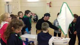
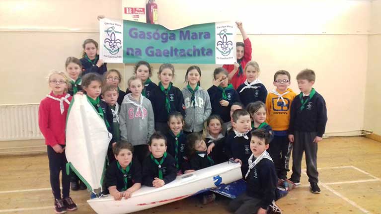
Lancer was repaired by Ciaran Oliver and James Rattigan from Port of Galway Sea Scouts, as previously reported on Afloat.ie.

The Sea Scouts recently visited the RV Celtic Explorer with Méabh and will also be attending a seashore safari with Galway Atlantaquaria and the Explorers Education Programme team later this month.
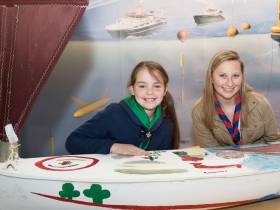
Published in Coastal Notes

When Kaitlyn Dow of Waterford High School in Connecticut put a shout–out through Afloat.ie last September for people to look out for her unmanned yacht off the Galway coast, little did she realise she would be travelling across the Atlantic to meet those finders and be reunited with her school project.

The 5ft mini–sailboat, The Lancer, was washed up in Connemara on September 20 last year. Sent by Dow of Waterford High School in Connecticut, it travelled all the way across the Atlantic, and was picked up by Méabh Ní Ghionnáin (aged 8) on Garumna Island, Co. Galway.

Since then, the Connemara Sea Scouts, who are affiliated with the ISA’s Galway Sea Scouts, have patched up The Lancer and are preparing to send it on another voyage.

Visitors from Waterford High School are due in Connemara in late February – so more updates to come.

Connemara Sea ScoutsThe Connemara Sea Scouts with the American mini yacht

Published in Coastal Notes

General Information on using Waterways Ireland inland navigations

Safety on the Water

All users of the navigations are strongly recommended to make themselves aware of safety on the water for whatever activity they are involved in and to read the advice offered by the various governing bodies and by:

The Dept. of Transport, Ireland: www.gov.ie/transport and The Maritime and Coastguard Agency, UK, The RNLI – Water Safety Ireland for information in terms of drowning prevention and water safety.

Registration of Vessels

All vessels using the Shannon Navigation, which includes the Shannon-Erne Waterways and the Erne System must be registered with Waterways Ireland. Only open undecked boats with an engine of 15 horsepower or less on the Shannon Navigation, and vessels of 10 horsepower or less on the Erne System, are exempt. Registration is free of charge.

Craft registration should be completed online at: https://www.waterwaysireland.org/online-services/craft-registration

Permits for use of the Grand and Royal Canals and the Barrow Navigation

All vessels using the Grand and Royal Canals and the Barrow Navigation must display appropriate valid Permit(s) i.e A Combined Mooring and Passage Permit (€126) and if not intending to move every five days, an Extended Mooring Permit (€152).

Permit applications should be completed online at: https://www.waterwaysireland.org/online-services/canal-permits

Passage on the Royal and Grand Canals – Dublin Area

For boat passage through the locks east of Lock 12 into / out of Dublin on either the Royal or Grand Canals, Masters are requested to contact the Waterways Ireland Eastern Regional Office (M-F 9.30am-4.30pm) on tel: +353(0)1 868 0148 or email [email protected] prior to making passage in order to plan the necessary lock-keeping assistance arrangements.

On the Grand Canal a minimum of two days notice prior to the planned passage should be given, masters should note that with the exception of pre-arranged events, a maximum of 2 boats per day will be taken through the locks, travelling either east or west.

Movements in or out of the city will be organised by prior arrangement to take place as a single movement in one day. Boaters will be facilitated to travel the system if their passage is considered to be safe by Waterways Ireland and they have the valid permit(s) for mooring and passage.

Newcomen Lifting Bridge

On the Royal Canal two weeks’ notice of bridge passage (Newcomen Lifting Bridge) is required for the pre-set lift date, and lock assistance will then also be arranged. A minimum of 2 boats is required for a bridge lift to go ahead.

Waterways Ireland Eastern Regional Office (Tel: +353(0)1 868 0148 or [email protected] ) is the point of contact for the bridge lift.

A maximum number of boats passing will be implemented to keep to the times given above for the planned lifts (16 for the Sat / Sun lifts & 8 for the weekday lifts). Priority will be given on a first come first served basis.

On day of lift, boaters and passengers must follow guidance from Waterways Ireland staff about sequence of passage under bridge & through Lock 1, and must remain within signed and designated areas.

Events Held on the Waterways

All organised events taking place on the waterways must have the prior approval of Waterways Ireland. This is a twelve week process and application forms must be accompanied with the appropriate insurance, signed indemnity and risk assessment. The application should be completed on the Waterways Ireland events page at :

https://www.waterwaysireland.org/online-services/event-approval

Time Limits on Mooring in Public Harbours

On the Shannon Navigation and the Shannon-Erne Waterway craft may berth in public harbours for five consecutive days or a total of seven days in any one month.

On the Erne System, revised Bye Laws state that: No master or owner shall permit a vessel, boat or any floating or sunken object to remain moored at or in the vicinity of any public mooring, including mooring at any other public mooring within 3 kilometres of that location, for more than 3 consecutive days and shall not moor at that same mooring or any other public mooring within 3 kilometres of that location within the following 3 consecutive days without prior permission by an authorised official.

Winter Mooring on the Shannon Navigation and Shannon Erne Waterway

Winter mooring may be availed of by owners during the period 1 Nov to 31 Mar by prior arrangement and payment of a charge of €63.50 per craft. Craft not availing of Winter Mooring must continue to comply with the “5 Day Rule”. Winter Mooring applications should be completed online at : https://www.waterwaysireland.org/online-services/winter-moorings-booking

Owners should be aware that electricity supply and water supply to public moorings is disconnected for the winter months. This is to protect against frost damage, to reduce running costs and to minimise maintenance requirements during the winter months.

Vessel owners are advised that advance purchasing of electricity on the power bollards leading up to the disconnection date should be minimal. Electricity credit existing on the bollards will not be recoverable after the winter decommissioning date. Both services will be reinstated prior to the commencement of the next boating season.

Smart Cards

Waterways Ireland smart cards are used to operate locks on the Shannon Erne Waterway, to access the service blocks, to use the pump-outs along the navigations, to avail of electrical power at Waterways Ireland jetties.

Berthing in Public Harbours

Masters are reminded of the following:

  • Equip their vessel with mooring lines of appropriate length and strength and only secure their craft to mooring bollards and cleats provided for this purpose.
  • Ensure the available berth is suitable to the length of your vessel, do not overhang the mooring especially on finger moorings on floating pontoon moorings.
  • Ensure mooring lines, electric cables and fresh water hoses do not create a trip hazard on public jetties for others users.
  • Carry sufficient fenders to prevent damage to your own vessel, other vessels and WI property.
  • Allow sufficient space between your vessel and the vessel ahead /astern (c.1m) for fire safety purposes and /or to recover somebody from the water.
  • Do not berth more than two vessels side by side and ensure there is safe access/egress at all times between vessels and onto the harbour itself.
  • Do not berth in such a way to prevent use of harbour safety ladders, slipways or pump-outs.
  • Do not allow the bow of your vessel to overhang the walkway of a floating mooring thus creating a hazard for others with an overhanging anchor or bow fendering.
  • Animals are not allowed to be loose or stray at any time.
  • Harbour and jetty infrastructure such as railings, power pedestals, fresh water taps, electric light poles, safety bollards, ladders etc are not designed for the purpose of mooring craft , they will not bear the strain of a vessel and will be damaged.
  • At Carrybridge on the Erne System, Masters of vessels are not permitted to use stern on mooring. Masters of vessels must use the mooring fingers for mooring of vessels and for embarkation / disembarkation from vessels.

Passenger Vessel Berths

Masters of vessels should not berth on passenger vessel berths where it is indicated that an arrival is imminent. Passenger vessels plying the navigations generally only occupy the berths to embark and disembark passengers and rarely remain on the berths for extended periods or overnight.

Lock Lead-in Jetties

Lead-in jetties adjacent to the upstream and downstream gates at lock chambers are solely for the purpose of craft waiting to use the lock and should not be used for long term berthing.

Vessel Wake

Vessel wake, that is, the wave generated by the passage of the boat through the water, can sometimes be large, powerful and destructive depending on the hull shape and engine power of the vessel. This wake can be detrimental to other users of the navigation when it strikes their craft or inundates the shoreline or riverbank. Masters are requested to frequently look behind and check the effect of their wake / wash particularly when passing moored vessels, on entering harbours and approaching jetties and to be aware of people pursuing other activities such as fishing on the riverbank.

Speed Restriction

A vessel or boat shall not be navigated on the Shannon Navigation at a speed in excess of 5 kph when within 200 metres of a bridge, quay, jetty or wharf, when in a harbour or canal or when passing within 100 metres of a moored vessel or boat.

Vessels navigating the Shannon-Erne Waterway should observe the general 5 kph speed limit which applies along the waterway. This is necessary in order to prevent damage to the banks caused by excessive wash from vessels.

Vessels navigating the Erne System should observe the statutory 5kt / 6mph / 10kph speed limit areas.

A craft on the Royal and Grand canals shall not be navigated at a speed in excess of 6km per hour.

A craft on the Barrow Navigation shall not be navigated at a speed in excess of 11km per hour except as necessary for safe navigation in conditions of fast flow.

Bank Erosion

Narrow sections of all the navigations are particularly prone to bank erosion due to the large wash generated by some craft. Masters are requested to be vigilant and to slow down to a speed sufficient to maintain steerage when they observe the wash of their craft inundating the river banks.

Unusual Waterborne Activity

Unusual waterborne vessels may be encountered from time to time, such as, hovercraft or amphibious aircraft / seaplanes. Masters of such craft are reminded to apply the normal “Rule of the Road” when they meet conventional craft on the water and to allow extra room to manoeuvre in the interest of safety.

Sailing Activity

Mariners will encounter large numbers of sailing dinghies from late June to August in the vicinity of Lough Derg, Lough Ree and Lower Lough Erne. Sailing courses are marked by yellow buoys to suit weather conditions on the day. Vessels should proceed at slow speed and with due caution and observe the rules of navigation when passing these fleets, as many of the participants are junior sailors under training.

Rowing

Mariners should expect to meet canoes and vessels under oars on any part of the navigations, but more so in the vicinity of Athlone, Carrick-on-Shannon, Coleraine, Enniskillen and Limerick. Masters are reminded to proceed at slow speed and especially to reduce their wash to a minimum when passing these craft as they can be easily upset and swamped due to their very low freeboard and always be prepared to give way in any given traffic situation.

Canoeing

Canoeing is an adventure sport and participants are strongly recommended to seek the advice of the sport’s governing bodies i.e Canoeing Ireland and the Canoe Association of Northern Ireland, before venturing onto the navigations.

Persons in charge of canoes are reminded of the inherent danger to these craft associated with operating close to weirs, sluice gates, locks and other infrastructure particularly when rivers are in flood and large volumes of water are moving through the navigations due to general flood conditions or very heavy localised precipitation e.g. turbulent and broken water, stopper waves. Shooting weirs is prohibited without prior permission of Waterways Ireland.

Canoeists should check with lockkeepers prior entering a lock to ensure passage is done in a safe manner. Portage is required at all unmanned locks.

Canoe Trail Network – "Blueways"

Masters of powered craft are reminded that a canoe trail network is being developed across all navigations and to expect more organised canoeing along these trails necessitating slow speed and minimum wash when encountering canoeists, rowing boats etc

Rockingham and Drummans Island Canals – Lough Key

It is expected that work on Rockingham and Drummans Island Canals on Lough Key will be completed in 2021. Access to these canals will be for non-powered craft only, eg canoes, kayaks, rowing boats.

Fast Powerboats and Personal Watercraft (Jet Skis)

Masters of Fast Powerboats (speed greater than 17kts) and Personal Watercraft (i.e.Jet Skis) are reminded of the inherent dangers associated with high speed on the water and especially in the confines of small bays and narrow sections of the navigations. Keeping a proper look-out, making early alterations to course and /or reducing speed will avoid conflict with slower vessels using the navigation. Personal Watercraft are not permitted to be used on the canals.

Towing Waterskiers, Wakeboarders, Doughnuts etc

Masters of vessels engaged in any of these activities are reminded of the manoeuvring constraints imposed upon their vessel by the tow and of the added responsibilities that they have to the person(s) being towed. These activities should be conducted in areas which are clear of conflicting traffic. It is highly recommended that a person additional to the master be carried to act as a “look-out” to keep the tow under observation at all times.

Prohibition on Swimming

Swimming in the navigable channel, particularly at bridges, is dangerous and is prohibited due to the risk of being run over by a vessel underway in the navigation.

Age Restrictions on operating of powered craft

In the Republic of Ireland, Statutory Instrument 921 of 2005 provides the legal requirements regarding the minimum age for operating of powered craft. The Statutory Instrument contains the following requirements:

- The master or owner of a personal watercraft or a fast power craft shall take all reasonable steps to ensure that a person who has not attained the age of 16 years does not operate or control the craft

- The master or owner of a pleasure craft powered by an engine with a rating of more than 5 horse power or 3.7 kilowatts shall take all reasonable steps to ensure that a person who has not attained the age of 12 years does not operate or control the craft.

Lifejackets and Personal Flotation Devices (PFDs)

Lifejackets and PFD’s are the single most important items of personal protective equipment to be used on a vessel and should be worn especially when the vessel is being manoeuvred such as entering / departing a lock, anchoring, coming alongside or departing a jetty or quayside.

In the Republic of Ireland, Statutory Instrument 921 of 2005 provides the legal requirements regarding the wearing of Personal Flotation Devices. The Statutory Instrument contains the following requirements:

- The master or owner of a pleasure craft (other than a personal watercraft) shall ensure, that there are, at all times on board the craft, sufficient suitable personal flotation devices for each person on board.

- A person on a pleasure craft (other than a personal watercraft) of less than 7 metres length overall shall wear a suitable personal flotation device while on board an open craft or while on the deck of decked craft, other than when the craft is made fast to the shore or at anchor.

- The master or owner of a pleasure craft (other than a personal watercraft) shall take all reasonable steps to ensure that a person who has not attained the age of 16 years complies with paragraph above.

- The master or owner of a pleasure craft (other than a personal watercraft), shall take all reasonable steps to ensure that a person who has not attained the age of 16 years wears a suitable personal flotation device while on board an open craft or while on the deck of a decked craft other than when it is made fast to the shore or at anchor.

- The master or owner of a pleasure craft (other than a personal watercraft) shall take all reasonable steps to ensure that a person wears a suitable personal flotation device, at all times while – (a) being towed by the craft, (b) on board a vessel or object of any kind which is being towed by the craft.

Further information is available at: http://www.irishstatutebook.ie/eli/2005/si/921/made/en/print

Firing Range Danger Area – Lough Ree

The attention of mariners is drawn to the Irish Defence Forces Firing Range situated in the vicinity of buoys No’s 2 and 3, on Lough Ree on the Shannon Navigation. This range is used regularly for live firing exercises, throughout the year, all boats and vessels should stay clear of the area marked with yellow buoys showing a yellow "X" topmark and displaying the word "Danger".

Shannon Navigation, Portumna Swing Bridge Tolls

No attempt should be made by Masters’ of vessels to pay the bridge toll while making way through the bridge opening. Payment will only be taken by the Collector from Masters when they are secured alongside the jetties north and south of the bridge.

Navigating from Killaloe to Limerick on the Shannon Navigation

The navigation from Killaloe to Limerick involves passage through Ardnacrusha locks, the associated headrace and tailrace and the Abbey River into Limerick City. Careful passage planning is required to undertake this voyage. Considerations include: lock passage at Ardnacrusha, water flow in the navigation, airdraft under bridges on Abbey River in Limerick, state of tide in Limerick

Users are advised to contact the ESB Ardnacrusha hydroelectric power station (00353 (0)87 9970131) 48 hours in advance of commencing their journey to book passage through the locks at Ardnacrusha. It is NOT advised to undertake a voyage if more than one turbine is operating (20MW), due to the increased velocity of flow in the navigation channel, which can be dangerous. To ascertain automatically in real time how many turbines are running, users can phone +353 (0)87 6477229.

For safety reasons the ESB has advised that only powered craft with a capacity in excess of 5 knots are allowed to enter Ardnacrusha Headrace and Tailrace Canals.

Passage through Sarsfield Lock should be booked on +353-87-7972998, on the day prior to travel and it should be noted also that transit is not possible two hours either side of low water.

A Hydrographic survey in 2020 of the navigation channel revealed that the approach from Shannon Bridge to Sarsfield Lock and the Dock area has silted up. Masters of vessels and water users are advised to navigate to the Lock from Shannon bridge on a rising tide one or two hours before High Tide.

Lower Bann Navigation

The attention of all users is drawn to the “Users Code for the Lower Bann”, in particular to that section covering “Flow in the River” outlining the dangers for users both on the banks and in the navigation, associated with high flow rates when the river is in spate. Canoeists should consult and carry a copy of the “Lower Bann Canoe Trail” guide issued by the Canoe Association of Northern Ireland. Users should also contact the DfI Rivers Coleraine, who is responsible for regulating the flow rates on the river, for advisory information on the flow rates to be expected on any given day.

DfI Rivers Coleraine. Tel: 0044 28 7034 2357 Email: [email protected]

Lower Bann Navigation – Newferry – No wake zone

A No Wake Zone exists on the Lower Bann Navigation at Newferry. Masters of vessels are requested to proceed at a slow speed and create no wake while passing the jetties and slipways at Newferry.

Overhead Power Lines (OHPL) and Air draft

All Masters must be aware of the dangers associated with overhead power lines, in particular sailing vessels and workboats with cranes or large air drafts. Voyage planning is a necessity in order to identify the location of overhead lines crossing the navigation.

Overhead power line heights on the River Shannon are maintained at 12.6metres (40 feet) from Normal Summer level for that section of navigation, masters of vessels with a large air draft should proceed with caution and make additional allowances when water levels are high.

If a vessel or its equipment comes into contact with an OHPL the operator should NOT attempt to move the vessel or equipment. The conductor may still be alive or re-energise automatically. Maintain a safe distance and prevent third parties from approaching due to risk of arcing. Contact the emergency services for assistance.

Anglers are also reminded that a minimum ground distance of 30 metres should be maintained from overhead power lines when using a rod and line.

Submarine Cables and Pipes

Masters of vessels are reminded not to anchor their vessels in the vicinity of submarine cables or pipes in case they foul their anchor or damage the cables or pipes. Look to the river banks for signage indicating their presence.

Water Levels - Precautions

Low Water Levels:

When water levels fall below normal summer levels masters should be aware of:

Navigation

To reduce the risk of grounding masters should navigate on or near the centreline of the channel, avoid short cutting in dog-legged channels and navigating too close to navigation markers.

Proceeding at a slow speed will also reduce “squat” effect i.e. where the vessel tends to sit lower in the water as a consequence of higher speed.

Slipways

Reduced slipway length available under the water surface and the possibility of launching trailers dropping off the end of the concrete apron.

More slipway surface susceptible to weed growth requiring care while engaged in launching boats, from slipping and sliding on the slope. Note also that launching vehicles may not be able to get sufficient traction on the slipway once the craft is launched to get up the incline.

Bank Erosion

Very dry riverbanks are more susceptible to erosion from vessel wash.

Lock Share

Maximising on the number of vessels in a lock will ensure that the total volume of water moving downstream is decreased. Lock cycles should be used for vessels travelling each way.

High Water Levels:

When water levels rise above normal summer level masters should be aware of:

Navigation

Navigation marks will have reduced height above the water level or may disappear underwater altogether making the navigable channel difficult to discern.

In narrow sections of the navigations water levels will tend to rise more quickly than in main streams and air draft at bridges will likewise be reduced.

There will also be increased flow rates particularly in the vicinity of navigation infrastructure such as bridges, weirs, locks etc where extra care in manoeuvring vessels will be required.

Harbours and Jetties

Due care is required in harbours and at slipways when levels are at or near the same level as the harbour walkways' as the edge will be difficult to discern especially in reduced light conditions. It is advised that Personal Flotation Devices be worn if tending to craft in a harbour in these conditions.

Slipways

Slipways should only be used for the purpose of launching and recovering of water craft or other objects from the water. Before using a slipway it should be examined to ensure that the surface has sufficient traction/grip for the intended purpose such as launching a craft from a trailer using a vehicle, that there is sufficient depth of water on the slipway to float the craft off the trailer before the concrete apron ends and that the wheels of the trailer do not drop off the edge of the slipway. That life-saving appliances are available in the vicinity, that the vehicle is roadworthy and capable of coping with the weight of the trailer and boat on the incline. It is recommended that slipway operations are conducted by two persons.

Caution to be Used in Reliance upon Aids to Navigation

The aids to navigation depicted on the navigation guides comprise a system of fixed and floating aids to navigation. Prudent mariners will not rely solely on any single aid to navigation, particularly a floating aid to navigation. With respect to buoys, the buoy symbol is used to indicate the approximate position of the buoy body and the ground tackle which secures it to the lake or river bed. The approximate position is used because of the practical limitations in positioning and maintaining buoys in precise geographical locations. These limitations include, but are not limited to, prevailing atmospheric and lake/river conditions, the slope of and the material making up the lake/river bed, the fact that the buoys are moored to varying lengths of chain, and the fact that the buoy body and/or ground tackle positions are not under continuous surveillance. Due to the forces of nature, the position of the buoy body can be expected to shift inside and outside the charted symbol.

Buoys and perches are also moved out of position or pulled over by those mariners who use them to moor up to instead of anchoring. To this end, mariners should always monitor their passage by relating buoy/perch positions with the published navigation guide. Furthermore, a vessel attempting to pass close by always risks collision with a yawing buoy or with the obstruction that the buoy or beacon/perch marks.

Masters of Vessels are requested to use the most up to date Navigation guides when navigating on the Inland Waterways.

Information taken from Special Marine Notice No 1 of 2023