Menu

Ireland's sailing, boating & maritime magazine

Inland afloat headers


Displaying items by tag: Loop Head

Amateur radio enthusiasts from across Ireland's midwest gathered at Loop Head Lighthouse Experience on the Shannon Estuary in County Clare over the weekend to participate in the 26th annual International Lighthouse and Lightship Weekend (ILLW). The event, which saw the Limerick Clare Radio Amateur Club broadcast non-stop for 48 hours from the West Clare lighthouse, involved using Morse Code and Single Sideband Radio to contact lighthouses and lightships around the world.

The Limerick Clare Radio Amateur Club has had great success in previous years, having contacted fellow radio amateurs in countries such as Australia, Brazil, and the US Virgin Islands. During this year's broadcast, visitors to the lighthouse were able to listen in on communications with some of the 500 lighthouses and lightships in over 40 countries that were activated by amateur radio enthusiasts.

Loop Head Lighthouse is an ideal location for long-distance radio communication attempts due to its isolated location on the edge of the Atlantic Ocean and the lack of radio interference in the general area. The Club operated two stations during the weekend, one of which was at the entrance to the Lighthouse so members of the public could listen to some of the transmissions.

Loop Head Lighthouse is one of 17 Great Lighthouses of Ireland and has become one of West Clare's most popular attractions since it first opened to visitors in 2011Loop Head Lighthouse is one of 17 Great Lighthouses of Ireland and has become one of West Clare's most popular attractions since it first opened to visitors in 2011

Joe Ryan, Secretary of the Limerick Clare Amateur Radio Club, expressed his gratitude to all the staff of Clare County Council and the Commissioners of Irish Lights for their help in planning the event and allowing them to use the grounds as part of the International Lighthouse and Lightships Weekend.

Loop Head Lighthouse Experience is one of 17 Great Lighthouses of Ireland and has become one of West Clare's most popular attractions since it first opened to visitors in 2011. The lighthouse also serves as one of two Signature Discovery Points in County Clare along the route of the Wild Atlantic Way.

Overall, the event was a great success and brought together radio enthusiasts from all over the world to share their love of communication and lighthouses.

See here for more information on the International Lighthouse and Lightships Weekend

Published in Shannon Estuary

Though it may not look it on a map which emphasises the extensive low water limits, at high water the Loop Head Peninsula in southwest County Clare is almost an island writes W M Nixon.

Only a couple of small roads lead into it from the main road between Kilrush and Kilkee, and once you’re into the Loop, you’re in a different country, a distinctive place with its own strong sense of identity.

It was here in Querrin that a voluntary group got together some years ago to build a boat to commemorate the small Shannon sailing hookers which were once the Loop Head Peninsula’s most important transport link for goods coming down the long estuary from Limerick.

loop head map2Loop Head Peninsula – a world apart with Carrigaholt at its heart

This local community group only had some ancient photos and sketches - and some vague old memories - to go by. But, guided by shipwright Steve Morris of Kilrush, they had naval architect Myles Stapleton of Malahide to bring his considerable talents to the task, and he created a wonderfully characterful 25-footer which looks good from any angle, sails well too, and can carry significant numbers to avail of Seol Sionna’s enthusiasm for spreading seagoing awareness. They’ve fresh plans afoot for 2018, and have sent us this cheerful message: 
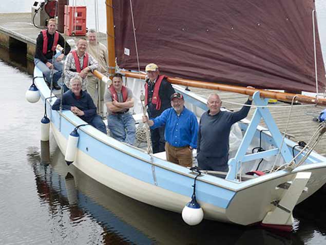
Sally O’Keeffe, the traditional wooden sail training vessel based on the Shannon Estuary, is currently gearing up for her seventh season on the ocean, and is putting a shout out to any and all who would wish to sail on her.
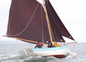
The 25-foot gaff rigged cutter was built by community group “Seol Sionna” under the guidance and tuition of local professional shipwright Steve Morris from plans drawn up by naval architect Myles Stapleton. Launched in Querrin in 2012 just 200 metres from where she was built, this craft has become one of the busiest and most capable sailing vessels on the Estuary.

sally okeeffe3The design of Sally O’Keeffe was neatly judged to provide the maximum on-board space Photo: W M Nixon

Seol Sionna offer a “traditional seafaring skills” course on board Sally O’Keeffe each summer, taking participants through all stages of sailing to competent crew level.
This is hands-on training - there are no winches or clutches, and the only buttons onboard are the chocolate ones that the skippers love! The atmosphere is fun and relaxed, but with a strong emphasis on safety.

On top of training, regular weekly sailing trips are made to various regions on the glorious estuary, picnics/walks/ birdwatching to Scattery Island, a jaunt to Carrigaholt for a pint and chowder, or out to Loop Head for a spot of fishing, for this is truly a versatile fun boat.

Over the past seven years, Sally (she’s named after the long-ago publican’s wife of Querrin) has shown her pedigree by sailing to and participating in traditional boat festivals in Baltimore and Glandore. There, she has taken first prize in her class on both occasions, confirming that she not only looks good, but sails well too.

This year’s plans are being finalised for taking Sally on a cruising trip up the west coast, taking in the Aran Islands and Inishbofin and calling in on Crinniú na Mbád in Kinvara on the way home.

Anyone interested in becoming a member can do so as a family, individual or concession for €60, €40, and €20 respectively. Training to competent crew level costs only €70, while daily membership is also available.

carmodys bar4
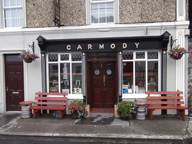
Carmody’s Bar, Carrigaholt – gather here on the night of Friday 23rd February to learn about Seol Sionna and Sally O’Keeffe

For more information, why not come along to Carmody's Bar at Carrigaholt on the 23rd February? There, a table quiz to raise funds for Seol Sionna will take place, and you may even win a free trip or two. Otherwise, check out Seol Sionna on Facebook or contact Fintan 087 2266501, Steve 087 7990091, or Richard 087 6744550.
And may you have fair winds and following seas.”

sally keeffe5
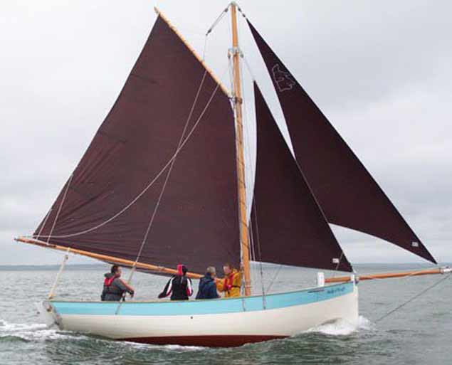
Community-built in Querrin on the Loop Head Peninsula, Sally O’Keeffe is a stylish design by Myles Stapleton.

Published in Shannon Estuary

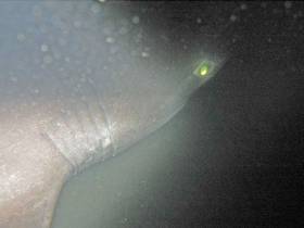
#Angling - A group of sea anglers off the Co Clare coast have hooked what’s thought to be the largest ever sixgill shark caught by rod and line in Europe.

As BBC News reports, English angler Ben Bond struggled for 90 minutes to reel in the 7.5m monster shark, which was photographed for record before being unhooked and released.

“Watching it swim away was probably the best part, I wouldn't want to kill such an impressive creature,” said Bond, who added he was thrilled by the experience off Loop Head last Thursday 4 May.

Though the shark was not weighed, Fishing in Ireland estimates it to be over 1,500lbs — more than 50% larger than a similar shark caught from the same boat off Co Clare just two days before.

BBC News has more on the story HERE.

Published in Angling
Tagged under

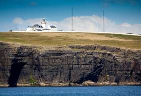
A record number of people visited Loop Head Lighthouse on the Shannon Estuary in County Clare during 2016.

Figures from Clare County Council show that 27,274 people visited the lighthouse during the opening period up to Sunday 2 October compared to 27,010 during the same period in 2015.

The increase in visitors represents the fifth successive annual increase in visitor numbers at the West Clare landmark.

Clare County Council, which manages the Lighthouse in conjunction with the Commissioner of Irish Lights (CIL), first opened the popular visitor attraction to the public in 2011.

Loop Head Lighthouse, which is steeped in history and rich in maritime heritage with its origins dating back to the 1670s, is a landmark location on the Loop Head Heritage Trail. It is also one of two Signature Discovery Points in County Clare along the route of the Wild Atlantic Way and is one of 12 Great Lighthouses of Ireland that won a Silver award this week at the Responsible Tourism Awards

Published in Lighthouses
Tagged under

#MarineWildlife - Holidaymakers on the Loop Head Peninsula sprang into action to rescue two common dolphins stranded on a nearby beach, as the Irish Examiner reports.

Visitors staying at Doonaha's Green Acres caravan park used buckets of water to keep the mother and calf wet and tarps to help lift them into deeper waters off the rocky shore before a team from Shannon Dolphin and Wildlife Foundation arrived.

The Irish Examiner has more on the story HERE.

Published in Marine Wildlife

Loop Head Lighthouse in West Clare, one of the Great Lighthouses of Ireland, will reopen to the public this Saturday (March 12th 2016).

Clare County Council, which manages the facility in conjunction with the Commissioners of Irish Lights (CIL), says the historic lighthouse will remain open daily (10am-6pm) until October 2nd.

The popular tourist attraction attracted 26,932 visitors during 2015. The figure represents an increase of 6,564 or 32% on 2014 visitor numbers.

Loop Head Lighthouse is a landmark location on the Loop Head Heritage Trail which was named winner of the 'Culture and Heritage' category of the 2015 World Responsible Tourism Awards. It is also one of twelve lighthouses which make up Great Lighthouses of Ireland, a new all-island tourism initiative, and is one of two Signature Discovery Points in County Clare along the route of the Wild Atlantic Way.

Cllr. James Breen, Cathaoirleach of Clare County Council said the lighthouse has become "a key driver" of visitor numbers to the Loop Head Peninsula since it was first opened to the public in 2011.

He added, "Loop Head Lighthouse truly is one of the tourism success stories for County Clare in recent years. It has helped to strengthen the profile, both nationally and internationally, of the wider Loop Head Peninsula and what it has to offer as a tourism destination. Its promotion as a Signature Discovery Point along the route of the Wild Atlantic Way has also ensured that the attraction has been promoted both in Ireland and overseas, which is reflected in the origin of visitors."

Almost half of the total visitor figure during 2015 was represented by Irish visitors, with Germany, North America, UK, France and Italy collectively accounting for more than 42% of the overall figure.

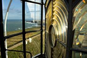
Loop Head Lighthouse, located at the mouth of the Shannon Estuary, is steeped in history and rich in maritime heritage with its origins dating back to the 1670s. The existing tower style lighthouse was constructed in 1854 and was operated and maintained by a keeper who lived within the lighthouse compound. In January 1991, the lighthouse was converted to automatic operation, and today is in the care of an attendant and is also monitored by the CIL.

Admission to Loop Head Lighthouse, which includes the exhibition and guided tour of the site, is Adults (€5), Children (Under 14 - €2) and Family Passes for up to 2 adults + 3 children (€12). Visit www.loophead.ie or www.clare.ie for more information on Loop Head Lighthouse and the Loop Head Peninsula.

Published in Lighthouses
Tagged under

#loophead – Former RTE newsreader and lighthouse enthusiast, Anne Doyle was in West Clare today where she joined Councillor John Crowe, Cathaoirleach of Clare County Council, in launching Loop Head Lighthouse's 2015 tourist season.

The historic landmark commenced its 5th year of operations when it reopened to the public on 03 April last. Clare County Council, which manages Loop Head Lighthouse in conjunction with the Commissioners of Irish Lights (CIL), says the facility will remain open daily (10am-6pm) until 4th October 2015.

Anne Doyle has been captivated by lighthouses since her childhood in Ferns, County Wexford, where she grew up observing the sweeping lights of the Tuskar Rock Lighthouse.

"Ireland's lighthouses hold so much history and are located in some of Western Europe's most scenic settings. Loop Head is no exception and the location of the lighthouse on the tip of the majestic Loop Head Peninsula and at the mouth of the Shannon Estuary makes it extra special," said Ms. Doyle.

Commenting on the launch of the 2015 visitor season, Councillor John Crowe said: "The 19th century West Clare landmark will be looking to capitalise on its designation as a Signature Discovery Point on the Wild Atlantic Way and further promote the economic development of the Loop Head Peninsula."

"Visitor numbers at the lighthouse have continued grow year on year since it was first opened to the public in 2011. During this time the lighthouse has delivered a major boost to economic activity in the wider area and I am confident it will further build on this in the months and years ahead," he added.

Loop Head Lighthouse is steeped in history and rich in maritime heritage with its origins dating back to the 1670s. The existing tower style lighthouse was constructed in 1854 and was operated and maintained by a keeper who lived within the lighthouse compound. Taoiseach Enda Kenny's grandfather was a keeper at the lighthouse. James John McGinley took up duty at the Lighthouse as Principal Keeper on 16th January 1933. He spent 1 year and 10 months at Loop Head. He was transferred from the station in October 1934.

Located to the rear of the lighthouse is an Éire sign etched into the headland, which was used to alert passing Allied aircrews that they were passing over neutral Ireland during World War Two.

In January 1991, the lighthouse was converted to automatic operation, and today is in the care of an attendant and is also monitored by the CIL.

Published in Lighthouses
Tagged under

#loophead – The historic Loop Head Lighthouse reopens to the public this Friday. The 19th century West Clare landmark will be looking to capitalise on its designation as a Signature Discovery Point on the Wild Atlantic Way by exceeding the 20,368 visitors it recorded during its six-month opening period during 2014.

Clare County Council, which manages Loop Head Lighthouse in conjunction with the Commissioners of Irish Lights (CIL), says the facility will remain open daily (10am-6pm) until 4th October 2015.

"2014, which was the lighthouse's fourth year of operation as a visitor attraction, saw visitor figures buoyed by the development of new services at Shannon Airport, favourable weather conditions and the launch of the Wild Atlantic Way," said Gerard Dollard, Director of Services, Tourism & Community, Clare County Council.

"We are confident that its status as one of Clare's most popular visitor attractions as well as a Signature Discovery Point on the Wild Atlantic Way will garner further interest from domestic and international visitors alike. Over its five years of operation the lighthouse project has been a major boost to economic activity in the wider area and we would hope to further build on this" added Mr. Dollard.

61% of the total visitor figure for 2014 was represented by Irish visitors, with North America, the United Kingdom and Germany each accounting for 8% of the overall figure. Italian and French visitors meanwhile, represented just over 5% of the total figure.

Loop Head Lighthouse, located at the mouth of the Shannon Estuary, has origins dating back to the 1670s. The existing tower style lighthouse was constructed in 1854 and was operated and maintained by a keeper who lived within the lighthouse compound.

Published in Shannon Estuary
Tagged under

#Tourism - Loop Head Peninsula has been named as one of the world's top 100 sustainable travel destinations, as The Irish Times reports.

The breathtaking Clare coastal spot is featured with the likes of the UK's Lake District and New Forest, Easter Island in the Pacific and the Wild Coast in South Africa's Eastern Cape in the first Sustainable Destinations Global Top 100 travel guide.

The Irish Times has more on the story HERE.

Published in Aquatic Tourism

#WAW – A pilot project that has resulted in the development of a heritage trail on 60km of the Wild Atlantic Way (WAW) is being hailed as a template for future similar developments along the West of Ireland coastal route from Donegal to West Cork.

Clare County Council, in partnership with Loop Head Tourism, The Heritage Council and Fáilte Ireland, today launched the Loop Head and Kilkee Heritage Trail on the Wild Atlantic Way.

The guide features 18 local heritage attractions including the West Clare Railway, the Church of the Little Ark, Kilkee Victorian Town and the Bridges of Ross, as well as other local WAW Discovery and Signature Points.

Through consultation with the local community and stakeholders, the pilot project also features recommendations to make it more streamlined and cost effective for other local communities to replicate the same project along the 2,500km WAW.

Cllr. John Crowe, Cathaoirleach of Clare County Council welcomed the selection of Kilkee and the Loop Head Peninsula as the location for the pilot project and said he hoped other WAW communities will be inspired to further enhance their tourism product offering.

He added: "The development and promotion of lesser known attractions is often overlooked even though they hold the key to revitalising the domestic tourism sector. The Loop Head Peninsula boasts a variety of local heritage sites and attractions, along with some of Ireland's most unique and breathtaking scenery. The development of this Trail complements work undertaken throughout the Loop Head Peninsula in recent years to develop and promote the local tourism product."

Congella McGuire, Heritage Officer with Clare County Council said Loop Head's growing reputation as a visitor destination has evolved as a result of "a bottom-up, community focused approach."

"The project is aimed at promoting a greater sense of understanding of the history, heritage, folklore and culture along the Wild Atlantic Way (WAW) route by connecting with and placing the local community at the core of this and future WAW projects," she said.

Ms. McGuire noted that a systematic project methodology was used in the development of the heritage trail.

"The first key task was the identification of potential heritage trail sites by the project steering group and key community representatives. An inspection of each of the 27 potential heritage sites was undertaken where a set of site assessment criteria were applied and this potential list was refined. This was followed by research and interpretation tasks surrounding the 18 sites on the final list and the Maritime History, Folklore and Traditions, Flora and Fauna, and Built, Military and Religious Heritage of the area," she commented.

Ms. McGuire continued: "The recommendations, processes and checklists outlined in the final project report should allow the project to be replicated and help future projects be more efficient, streamlined and cost effective. They also provide a clear model for working with the local community and stakeholders and will help deliver high quality and consistent design ready interpretation content along the entire WAW."

Cillian Murphy, Chairperson of Loop Head Tourism commented: "We are delighted to have had this opportunity to work with The Heritage Council, Failte Ireland and Clare County Council on developing the first destination led heritage trail on the WAW. It is testament to the hard work done by the group over the last number of years that we were chosen to be the pilot project on how to showcase our local heritage to visitors, enticing them to slow down and spend a little longer in each destination along the Wild Atlantic Way."

"The resulting Loop Head Peninsula Heritage Trail is a shining example of what can be achieved when statutory agencies and local community groups co-operate in a bottom up approach to tourism development. County Clare has placed itself at the forefront of responsible tourism development in Ireland over the last number of years and this project is further proof of that decision paying dividends and benefiting both locals and visitors alike," added Mr. Murphy.

The Loop Head and Kilkee Heritage Trail on the Wild Atlantic Way features Carrigaholt Castle and Bay, Bridges of Ross, Kilkee Cliffs and Pollock Holes (WAW Discovery Points), Church of the Little Ark (WAW Signature Point), Blackweir Bridge, Doonaha Ringforts, Tullig Famine Village, Corbally and Coosheen (Heritage Areas), Bishops Island, Dunlicka Castle, Loop Head, Pilots Memorial and Kilbaha Bay, Grave of the Yellow Men, Rinevella Bay and Submerged Forest, Kilcredaun Churches and Holy Well, Kilcredaun Churches and Holy Well, Querrin Pier and the West Clare Railway (Heritage Sites).

The Trail Z-Card will shortly be made available throughout the region.

Published in Aquatic Tourism
Page 1 of 3

General Information on using Waterways Ireland inland navigations

Safety on the Water

All users of the navigations are strongly recommended to make themselves aware of safety on the water for whatever activity they are involved in and to read the advice offered by the various governing bodies and by:

The Dept. of Transport, Ireland: www.gov.ie/transport and The Maritime and Coastguard Agency, UK, The RNLI – Water Safety Ireland for information in terms of drowning prevention and water safety.

Registration of Vessels

All vessels using the Shannon Navigation, which includes the Shannon-Erne Waterways and the Erne System must be registered with Waterways Ireland. Only open undecked boats with an engine of 15 horsepower or less on the Shannon Navigation, and vessels of 10 horsepower or less on the Erne System, are exempt. Registration is free of charge.

Craft registration should be completed online at: https://www.waterwaysireland.org/online-services/craft-registration

Permits for use of the Grand and Royal Canals and the Barrow Navigation

All vessels using the Grand and Royal Canals and the Barrow Navigation must display appropriate valid Permit(s) i.e A Combined Mooring and Passage Permit (€126) and if not intending to move every five days, an Extended Mooring Permit (€152).

Permit applications should be completed online at: https://www.waterwaysireland.org/online-services/canal-permits

Passage on the Royal and Grand Canals – Dublin Area

For boat passage through the locks east of Lock 12 into / out of Dublin on either the Royal or Grand Canals, Masters are requested to contact the Waterways Ireland Eastern Regional Office (M-F 9.30am-4.30pm) on tel: +353(0)1 868 0148 or email [email protected] prior to making passage in order to plan the necessary lock-keeping assistance arrangements.

On the Grand Canal a minimum of two days notice prior to the planned passage should be given, masters should note that with the exception of pre-arranged events, a maximum of 2 boats per day will be taken through the locks, travelling either east or west.

Movements in or out of the city will be organised by prior arrangement to take place as a single movement in one day. Boaters will be facilitated to travel the system if their passage is considered to be safe by Waterways Ireland and they have the valid permit(s) for mooring and passage.

Newcomen Lifting Bridge

On the Royal Canal two weeks’ notice of bridge passage (Newcomen Lifting Bridge) is required for the pre-set lift date, and lock assistance will then also be arranged. A minimum of 2 boats is required for a bridge lift to go ahead.

Waterways Ireland Eastern Regional Office (Tel: +353(0)1 868 0148 or [email protected] ) is the point of contact for the bridge lift.

A maximum number of boats passing will be implemented to keep to the times given above for the planned lifts (16 for the Sat / Sun lifts & 8 for the weekday lifts). Priority will be given on a first come first served basis.

On day of lift, boaters and passengers must follow guidance from Waterways Ireland staff about sequence of passage under bridge & through Lock 1, and must remain within signed and designated areas.

Events Held on the Waterways

All organised events taking place on the waterways must have the prior approval of Waterways Ireland. This is a twelve week process and application forms must be accompanied with the appropriate insurance, signed indemnity and risk assessment. The application should be completed on the Waterways Ireland events page at :

https://www.waterwaysireland.org/online-services/event-approval

Time Limits on Mooring in Public Harbours

On the Shannon Navigation and the Shannon-Erne Waterway craft may berth in public harbours for five consecutive days or a total of seven days in any one month.

On the Erne System, revised Bye Laws state that: No master or owner shall permit a vessel, boat or any floating or sunken object to remain moored at or in the vicinity of any public mooring, including mooring at any other public mooring within 3 kilometres of that location, for more than 3 consecutive days and shall not moor at that same mooring or any other public mooring within 3 kilometres of that location within the following 3 consecutive days without prior permission by an authorised official.

Winter Mooring on the Shannon Navigation and Shannon Erne Waterway

Winter mooring may be availed of by owners during the period 1 Nov to 31 Mar by prior arrangement and payment of a charge of €63.50 per craft. Craft not availing of Winter Mooring must continue to comply with the “5 Day Rule”. Winter Mooring applications should be completed online at : https://www.waterwaysireland.org/online-services/winter-moorings-booking

Owners should be aware that electricity supply and water supply to public moorings is disconnected for the winter months. This is to protect against frost damage, to reduce running costs and to minimise maintenance requirements during the winter months.

Vessel owners are advised that advance purchasing of electricity on the power bollards leading up to the disconnection date should be minimal. Electricity credit existing on the bollards will not be recoverable after the winter decommissioning date. Both services will be reinstated prior to the commencement of the next boating season.

Smart Cards

Waterways Ireland smart cards are used to operate locks on the Shannon Erne Waterway, to access the service blocks, to use the pump-outs along the navigations, to avail of electrical power at Waterways Ireland jetties.

Berthing in Public Harbours

Masters are reminded of the following:

  • Equip their vessel with mooring lines of appropriate length and strength and only secure their craft to mooring bollards and cleats provided for this purpose.
  • Ensure the available berth is suitable to the length of your vessel, do not overhang the mooring especially on finger moorings on floating pontoon moorings.
  • Ensure mooring lines, electric cables and fresh water hoses do not create a trip hazard on public jetties for others users.
  • Carry sufficient fenders to prevent damage to your own vessel, other vessels and WI property.
  • Allow sufficient space between your vessel and the vessel ahead /astern (c.1m) for fire safety purposes and /or to recover somebody from the water.
  • Do not berth more than two vessels side by side and ensure there is safe access/egress at all times between vessels and onto the harbour itself.
  • Do not berth in such a way to prevent use of harbour safety ladders, slipways or pump-outs.
  • Do not allow the bow of your vessel to overhang the walkway of a floating mooring thus creating a hazard for others with an overhanging anchor or bow fendering.
  • Animals are not allowed to be loose or stray at any time.
  • Harbour and jetty infrastructure such as railings, power pedestals, fresh water taps, electric light poles, safety bollards, ladders etc are not designed for the purpose of mooring craft , they will not bear the strain of a vessel and will be damaged.
  • At Carrybridge on the Erne System, Masters of vessels are not permitted to use stern on mooring. Masters of vessels must use the mooring fingers for mooring of vessels and for embarkation / disembarkation from vessels.

Passenger Vessel Berths

Masters of vessels should not berth on passenger vessel berths where it is indicated that an arrival is imminent. Passenger vessels plying the navigations generally only occupy the berths to embark and disembark passengers and rarely remain on the berths for extended periods or overnight.

Lock Lead-in Jetties

Lead-in jetties adjacent to the upstream and downstream gates at lock chambers are solely for the purpose of craft waiting to use the lock and should not be used for long term berthing.

Vessel Wake

Vessel wake, that is, the wave generated by the passage of the boat through the water, can sometimes be large, powerful and destructive depending on the hull shape and engine power of the vessel. This wake can be detrimental to other users of the navigation when it strikes their craft or inundates the shoreline or riverbank. Masters are requested to frequently look behind and check the effect of their wake / wash particularly when passing moored vessels, on entering harbours and approaching jetties and to be aware of people pursuing other activities such as fishing on the riverbank.

Speed Restriction

A vessel or boat shall not be navigated on the Shannon Navigation at a speed in excess of 5 kph when within 200 metres of a bridge, quay, jetty or wharf, when in a harbour or canal or when passing within 100 metres of a moored vessel or boat.

Vessels navigating the Shannon-Erne Waterway should observe the general 5 kph speed limit which applies along the waterway. This is necessary in order to prevent damage to the banks caused by excessive wash from vessels.

Vessels navigating the Erne System should observe the statutory 5kt / 6mph / 10kph speed limit areas.

A craft on the Royal and Grand canals shall not be navigated at a speed in excess of 6km per hour.

A craft on the Barrow Navigation shall not be navigated at a speed in excess of 11km per hour except as necessary for safe navigation in conditions of fast flow.

Bank Erosion

Narrow sections of all the navigations are particularly prone to bank erosion due to the large wash generated by some craft. Masters are requested to be vigilant and to slow down to a speed sufficient to maintain steerage when they observe the wash of their craft inundating the river banks.

Unusual Waterborne Activity

Unusual waterborne vessels may be encountered from time to time, such as, hovercraft or amphibious aircraft / seaplanes. Masters of such craft are reminded to apply the normal “Rule of the Road” when they meet conventional craft on the water and to allow extra room to manoeuvre in the interest of safety.

Sailing Activity

Mariners will encounter large numbers of sailing dinghies from late June to August in the vicinity of Lough Derg, Lough Ree and Lower Lough Erne. Sailing courses are marked by yellow buoys to suit weather conditions on the day. Vessels should proceed at slow speed and with due caution and observe the rules of navigation when passing these fleets, as many of the participants are junior sailors under training.

Rowing

Mariners should expect to meet canoes and vessels under oars on any part of the navigations, but more so in the vicinity of Athlone, Carrick-on-Shannon, Coleraine, Enniskillen and Limerick. Masters are reminded to proceed at slow speed and especially to reduce their wash to a minimum when passing these craft as they can be easily upset and swamped due to their very low freeboard and always be prepared to give way in any given traffic situation.

Canoeing

Canoeing is an adventure sport and participants are strongly recommended to seek the advice of the sport’s governing bodies i.e Canoeing Ireland and the Canoe Association of Northern Ireland, before venturing onto the navigations.

Persons in charge of canoes are reminded of the inherent danger to these craft associated with operating close to weirs, sluice gates, locks and other infrastructure particularly when rivers are in flood and large volumes of water are moving through the navigations due to general flood conditions or very heavy localised precipitation e.g. turbulent and broken water, stopper waves. Shooting weirs is prohibited without prior permission of Waterways Ireland.

Canoeists should check with lockkeepers prior entering a lock to ensure passage is done in a safe manner. Portage is required at all unmanned locks.

Canoe Trail Network – "Blueways"

Masters of powered craft are reminded that a canoe trail network is being developed across all navigations and to expect more organised canoeing along these trails necessitating slow speed and minimum wash when encountering canoeists, rowing boats etc

Rockingham and Drummans Island Canals – Lough Key

It is expected that work on Rockingham and Drummans Island Canals on Lough Key will be completed in 2021. Access to these canals will be for non-powered craft only, eg canoes, kayaks, rowing boats.

Fast Powerboats and Personal Watercraft (Jet Skis)

Masters of Fast Powerboats (speed greater than 17kts) and Personal Watercraft (i.e.Jet Skis) are reminded of the inherent dangers associated with high speed on the water and especially in the confines of small bays and narrow sections of the navigations. Keeping a proper look-out, making early alterations to course and /or reducing speed will avoid conflict with slower vessels using the navigation. Personal Watercraft are not permitted to be used on the canals.

Towing Waterskiers, Wakeboarders, Doughnuts etc

Masters of vessels engaged in any of these activities are reminded of the manoeuvring constraints imposed upon their vessel by the tow and of the added responsibilities that they have to the person(s) being towed. These activities should be conducted in areas which are clear of conflicting traffic. It is highly recommended that a person additional to the master be carried to act as a “look-out” to keep the tow under observation at all times.

Prohibition on Swimming

Swimming in the navigable channel, particularly at bridges, is dangerous and is prohibited due to the risk of being run over by a vessel underway in the navigation.

Age Restrictions on operating of powered craft

In the Republic of Ireland, Statutory Instrument 921 of 2005 provides the legal requirements regarding the minimum age for operating of powered craft. The Statutory Instrument contains the following requirements:

- The master or owner of a personal watercraft or a fast power craft shall take all reasonable steps to ensure that a person who has not attained the age of 16 years does not operate or control the craft

- The master or owner of a pleasure craft powered by an engine with a rating of more than 5 horse power or 3.7 kilowatts shall take all reasonable steps to ensure that a person who has not attained the age of 12 years does not operate or control the craft.

Lifejackets and Personal Flotation Devices (PFDs)

Lifejackets and PFD’s are the single most important items of personal protective equipment to be used on a vessel and should be worn especially when the vessel is being manoeuvred such as entering / departing a lock, anchoring, coming alongside or departing a jetty or quayside.

In the Republic of Ireland, Statutory Instrument 921 of 2005 provides the legal requirements regarding the wearing of Personal Flotation Devices. The Statutory Instrument contains the following requirements:

- The master or owner of a pleasure craft (other than a personal watercraft) shall ensure, that there are, at all times on board the craft, sufficient suitable personal flotation devices for each person on board.

- A person on a pleasure craft (other than a personal watercraft) of less than 7 metres length overall shall wear a suitable personal flotation device while on board an open craft or while on the deck of decked craft, other than when the craft is made fast to the shore or at anchor.

- The master or owner of a pleasure craft (other than a personal watercraft) shall take all reasonable steps to ensure that a person who has not attained the age of 16 years complies with paragraph above.

- The master or owner of a pleasure craft (other than a personal watercraft), shall take all reasonable steps to ensure that a person who has not attained the age of 16 years wears a suitable personal flotation device while on board an open craft or while on the deck of a decked craft other than when it is made fast to the shore or at anchor.

- The master or owner of a pleasure craft (other than a personal watercraft) shall take all reasonable steps to ensure that a person wears a suitable personal flotation device, at all times while – (a) being towed by the craft, (b) on board a vessel or object of any kind which is being towed by the craft.

Further information is available at: http://www.irishstatutebook.ie/eli/2005/si/921/made/en/print

Firing Range Danger Area – Lough Ree

The attention of mariners is drawn to the Irish Defence Forces Firing Range situated in the vicinity of buoys No’s 2 and 3, on Lough Ree on the Shannon Navigation. This range is used regularly for live firing exercises, throughout the year, all boats and vessels should stay clear of the area marked with yellow buoys showing a yellow "X" topmark and displaying the word "Danger".

Shannon Navigation, Portumna Swing Bridge Tolls

No attempt should be made by Masters’ of vessels to pay the bridge toll while making way through the bridge opening. Payment will only be taken by the Collector from Masters when they are secured alongside the jetties north and south of the bridge.

Navigating from Killaloe to Limerick on the Shannon Navigation

The navigation from Killaloe to Limerick involves passage through Ardnacrusha locks, the associated headrace and tailrace and the Abbey River into Limerick City. Careful passage planning is required to undertake this voyage. Considerations include: lock passage at Ardnacrusha, water flow in the navigation, airdraft under bridges on Abbey River in Limerick, state of tide in Limerick

Users are advised to contact the ESB Ardnacrusha hydroelectric power station (00353 (0)87 9970131) 48 hours in advance of commencing their journey to book passage through the locks at Ardnacrusha. It is NOT advised to undertake a voyage if more than one turbine is operating (20MW), due to the increased velocity of flow in the navigation channel, which can be dangerous. To ascertain automatically in real time how many turbines are running, users can phone +353 (0)87 6477229.

For safety reasons the ESB has advised that only powered craft with a capacity in excess of 5 knots are allowed to enter Ardnacrusha Headrace and Tailrace Canals.

Passage through Sarsfield Lock should be booked on +353-87-7972998, on the day prior to travel and it should be noted also that transit is not possible two hours either side of low water.

A Hydrographic survey in 2020 of the navigation channel revealed that the approach from Shannon Bridge to Sarsfield Lock and the Dock area has silted up. Masters of vessels and water users are advised to navigate to the Lock from Shannon bridge on a rising tide one or two hours before High Tide.

Lower Bann Navigation

The attention of all users is drawn to the “Users Code for the Lower Bann”, in particular to that section covering “Flow in the River” outlining the dangers for users both on the banks and in the navigation, associated with high flow rates when the river is in spate. Canoeists should consult and carry a copy of the “Lower Bann Canoe Trail” guide issued by the Canoe Association of Northern Ireland. Users should also contact the DfI Rivers Coleraine, who is responsible for regulating the flow rates on the river, for advisory information on the flow rates to be expected on any given day.

DfI Rivers Coleraine. Tel: 0044 28 7034 2357 Email: [email protected]

Lower Bann Navigation – Newferry – No wake zone

A No Wake Zone exists on the Lower Bann Navigation at Newferry. Masters of vessels are requested to proceed at a slow speed and create no wake while passing the jetties and slipways at Newferry.

Overhead Power Lines (OHPL) and Air draft

All Masters must be aware of the dangers associated with overhead power lines, in particular sailing vessels and workboats with cranes or large air drafts. Voyage planning is a necessity in order to identify the location of overhead lines crossing the navigation.

Overhead power line heights on the River Shannon are maintained at 12.6metres (40 feet) from Normal Summer level for that section of navigation, masters of vessels with a large air draft should proceed with caution and make additional allowances when water levels are high.

If a vessel or its equipment comes into contact with an OHPL the operator should NOT attempt to move the vessel or equipment. The conductor may still be alive or re-energise automatically. Maintain a safe distance and prevent third parties from approaching due to risk of arcing. Contact the emergency services for assistance.

Anglers are also reminded that a minimum ground distance of 30 metres should be maintained from overhead power lines when using a rod and line.

Submarine Cables and Pipes

Masters of vessels are reminded not to anchor their vessels in the vicinity of submarine cables or pipes in case they foul their anchor or damage the cables or pipes. Look to the river banks for signage indicating their presence.

Water Levels - Precautions

Low Water Levels:

When water levels fall below normal summer levels masters should be aware of:

Navigation

To reduce the risk of grounding masters should navigate on or near the centreline of the channel, avoid short cutting in dog-legged channels and navigating too close to navigation markers.

Proceeding at a slow speed will also reduce “squat” effect i.e. where the vessel tends to sit lower in the water as a consequence of higher speed.

Slipways

Reduced slipway length available under the water surface and the possibility of launching trailers dropping off the end of the concrete apron.

More slipway surface susceptible to weed growth requiring care while engaged in launching boats, from slipping and sliding on the slope. Note also that launching vehicles may not be able to get sufficient traction on the slipway once the craft is launched to get up the incline.

Bank Erosion

Very dry riverbanks are more susceptible to erosion from vessel wash.

Lock Share

Maximising on the number of vessels in a lock will ensure that the total volume of water moving downstream is decreased. Lock cycles should be used for vessels travelling each way.

High Water Levels:

When water levels rise above normal summer level masters should be aware of:

Navigation

Navigation marks will have reduced height above the water level or may disappear underwater altogether making the navigable channel difficult to discern.

In narrow sections of the navigations water levels will tend to rise more quickly than in main streams and air draft at bridges will likewise be reduced.

There will also be increased flow rates particularly in the vicinity of navigation infrastructure such as bridges, weirs, locks etc where extra care in manoeuvring vessels will be required.

Harbours and Jetties

Due care is required in harbours and at slipways when levels are at or near the same level as the harbour walkways' as the edge will be difficult to discern especially in reduced light conditions. It is advised that Personal Flotation Devices be worn if tending to craft in a harbour in these conditions.

Slipways

Slipways should only be used for the purpose of launching and recovering of water craft or other objects from the water. Before using a slipway it should be examined to ensure that the surface has sufficient traction/grip for the intended purpose such as launching a craft from a trailer using a vehicle, that there is sufficient depth of water on the slipway to float the craft off the trailer before the concrete apron ends and that the wheels of the trailer do not drop off the edge of the slipway. That life-saving appliances are available in the vicinity, that the vehicle is roadworthy and capable of coping with the weight of the trailer and boat on the incline. It is recommended that slipway operations are conducted by two persons.

Caution to be Used in Reliance upon Aids to Navigation

The aids to navigation depicted on the navigation guides comprise a system of fixed and floating aids to navigation. Prudent mariners will not rely solely on any single aid to navigation, particularly a floating aid to navigation. With respect to buoys, the buoy symbol is used to indicate the approximate position of the buoy body and the ground tackle which secures it to the lake or river bed. The approximate position is used because of the practical limitations in positioning and maintaining buoys in precise geographical locations. These limitations include, but are not limited to, prevailing atmospheric and lake/river conditions, the slope of and the material making up the lake/river bed, the fact that the buoys are moored to varying lengths of chain, and the fact that the buoy body and/or ground tackle positions are not under continuous surveillance. Due to the forces of nature, the position of the buoy body can be expected to shift inside and outside the charted symbol.

Buoys and perches are also moved out of position or pulled over by those mariners who use them to moor up to instead of anchoring. To this end, mariners should always monitor their passage by relating buoy/perch positions with the published navigation guide. Furthermore, a vessel attempting to pass close by always risks collision with a yawing buoy or with the obstruction that the buoy or beacon/perch marks.

Masters of Vessels are requested to use the most up to date Navigation guides when navigating on the Inland Waterways.

Information taken from Special Marine Notice No 1 of 2023