Menu

Ireland's sailing, boating & maritime magazine

Inland afloat headers


Displaying items by tag: Ports and Shipping News

#WeighingContainers - All “shippers” as from July 2016 must declare to the carrier in advance the verified weight of packed containers.

The European Sea Port Organisation (ESPO) has joined the European organisations representing Shippers, Freight Forwarders and Terminal Operators in the call on national authorities to avoid any disruption in the logistics chain and to take action in coordination to preserve level playing field.

To ensure that the implementation of the new legal requirements does not create competition distortion through a patchwork of varying national measures, Member States should pursue a coordinated approach, taking into consideration the national guidelines of other Member States when deciding on national rules. Commonly accepted guidelines between supply chain actors and national authorities could minimise distortion of competition and ensure smooth functioning of the SOLAS requirements.

Being only two months away from the entry into force of the SOLAS convention, Member States should bring clarity as soon as possible.

In November 2014, the International Maritime Organisation (IMO) agreed upon rules for the mandatory weighing of all sea-bound containers to be loaded on a vessel. The undersigned organisations accept these rules and are committed to working towards the successful implementation of the new legal obligation.

Published in Ports & Shipping

#MVIrelandLaunch - M.V. Ireland, yes a vessel named after our country was launched a month ago today and is never too late mention, notably given the newbuild is one of the first dry cargoships ever to be powered by (LNG) liquefied natural gas, writes Jehan Ashmore.

The state of the art 3,600 tons cement-carrier tanker was christened at Ferus Smit's Westerbroek shipyard in the Netherlands, where a jazz band mingled among workers, guests and dignataries.

Despite her name the 110m long newbuild has no connections with the Irish maritime industry. The owners of this second sister along with M.V. Greenland already in service, are JT cement, a joint venture between Erik Thun AB and KG Jebsen Cement (KGJ) of Norway.

M.V. Ireland is registered at the Dutch port of Delfzijl on the Eems estuary and flies that nation's flag. 

The liquefied natural gas (LNG) fuelled propulsion system incorporates a pressurised LNG tank positioned in the foreship. By using LNG as maritime fuel, this according to Dutch builder, is by far the most environmental-friendly solution available today.

While sailing on LNG, the vessel will meet the most stringent emission criteria, as well as new norms that might be in place in future.

The ship is equipped with a fully automated cement loading and unloading system, based on the principle of fluidization of cement with compressed air. This system enables the cement to be pumped through a completely closed, thus dust free, piping system to shore facilities.

Published in Ports & Shipping

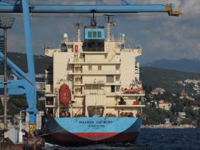
#CaptainPhillips – Containership Antwerp which departed Dublin Port this morning, is a sister of Maersk Alabama which Somali pirates hijacked in 2009 and where the film 'Captain Phillips' is based from, writes Jehan Ashmore.

The 14,120 tonnes Maersk Alabama is the leadship and namesake of this containership class and is reputed to be the first U.S. cargoship to be hijacked in two hundred years. The pirates took over the 155m long containership under the command of Captain Richard Phillips. In the 2013 film, his character was played by actor Tom Hanks.

Only a year separates the 1998 built Maersk Alabama from the Maersk Antwerp which was renamed in recent years. The 1,058 TEU containership made the first ever direct call to Dublin Port yesterday for the Maersk Group subsidiary, Seago Line on the new UK (Liverpool)-Ireland-Spain (Algeciras) service.

The Antwerp which is one of the larger containerships to call to Dublin, departed this morning to begin in completing the first round trip of the new service. This involves the third and final leg which is bound for the southern Spanish port located west of Gibraltar. 

Published in Ports & Shipping

#CargoRosslare – A pair of cargoships loaded with timber in Scotland docked at Rosslare Europort, where the outlook in this trade in 2016 is for further growth at the Wexford ferryport, writes Jehan Ashmore.

Cargoship, Ayress (1979/1,713grt) loaded in Ayr on the Forth of CLyde with round timber (i.e. logs) that was discharged yesterday at Rosslare. Following that call, the Islay Trader (1992/2,386grt) loaded with cargo from Campbeltown on the Mull of Kintyre was also unloaded at the Irish port. 

The timber trade began slowly in 2013/2014, but in 2015 about 20,000 tonnes of logs were imported through Rosslare using 12 shipments. Typical loading trading ports are from Scottish west coast ports, mainly Ardrishaig and Sandbank, with the occasional shipment from Campbeltown.

Both short-sea coasters berthed at Fisherman’s Quay which is the westernmost of the quays, leaving the other two piers dedicated to ferry traffic serving Wales and France. Irish Ferries operate to Pembroke, Cherbourg and Roscoff and Stena Line to Fishguard and also to Cherbourg.

The south-eastern port is also to welcome business from the cruise industry, in which Afloat will have more in an update this weekend.

Published in Ports & Shipping

#Successful2015 - According to the latest edition of the Irish Maritime Transport Economist (IMTE) the year 2015 has been successful for the maritime industry. The annual publication is issued by the Irish Maritime Development Office (IMDO).

The iShip Index, which measures the total volume of traffic moving through our national ports, recorded a 7% increase, with all major traffic modes delivering substantial growth.                              

Bulk traffic grew by 7% to reach 29.8 million tonnes, with Cork, Greenore, Shannon Foynes, Waterford and Wicklow recording above average growth rates.

LoLo traffic, moving predominantly through Dublin, Cork and Waterford, grew by 8% to 860,277 TEU, with each port recording significant volume gains.

RoRo traffic grew by 6% to 1,002,920 units, 88% of which was shipped through Dublin and 12% through Rosslare.

The total volume of traffic that moved through Irish ports in 2015 reached its highest level since 2008, at 977 points on the iShip Index. Although this is 7% lower than the peak of 1,042 points achieved in 2007, it represents substantial progress from the low of 693 points recorded in 2009, and is the highest level recorded since the beginning of the economic crisis.

Domestic economic conditions in 2015 contributed to the growth of the maritime industry. GDP was up by 7.8% to €203.5 billion and GNP was up by 5.7% to €171.9 billion. In value terms, exports in merchandise trade grew by 20%, while imports rose by 10%. The Central Bank of Ireland forecasts a continuation of this strong trading performance, with overall exports set to grow by a further 6.5% in 2016 and 4.9% in 2017. The Central Bank estimates that the value of imports will grow by 6.9% in 2016 and 4.4% in 2017. These strong growth rates bode well for the continued recovery and expansion of the Irish maritime industry.

Our ports are important gateways for inbound and outbound tourism and make a very significant contribution to the success of the tourism industry. More than 4.4 million passengers travelled through Dublin, Rosslare and Cork in 2015, availing of the many excellent ferry services that connect Irish ports to ports in Great Britain and France. A further 450,000 tourists experienced Ireland through port calls made by 246 cruise liners that called to Irish ports in 2015, an increase of 3% on the previous year.

Commenting on the strong performance of the industry in 2015, Liam Lacey, Director of the IMDO said “the economic contribution made by our ports to the broader economy is recognised in the Government’s integrated plan for the marine industry - Harnessing Our Ocean Wealth. The plan describes ports as enablers of economic growth. Their competitiveness and efficiency impact directly on international trade and have a direct influence on the job creation capacity of the economy.”

Director Lacey added, “As our ports move closer to the peak volumes handled in 2007/2008, it is important to address the need for additional capacity. Ambitious development plans, capable of meeting the growing needs of the national economy, have been progressed by Dublin, Cork, and Shannon Foynes and will be brought to fruition over the next five years. It is also important for other regional ports to consider the role that they will play in the provision of future capacity and in the achievement of the economic objectives set out in the Harnessing Our Ocean Wealth Strategy.”

“Apart from providing the infrastructure that is needed for shipping, our ports are important transport and logistics hubs for heavy industry requiring access to seaborne transport. A number of Irish ports have naturally occurring deep water and shore-side capacity to handle the largest ocean-going vessels and the cargoes they carry. Irish ports are also capable of providing the services and infrastructure required by the marine renewable energy industry, in which Ireland has a strategic interest.”

According to IMDO Director Lacey “The contribution that Irish ports can make to the broader marine economy by participating in these diverse activities is also recognised in the Harnessing Our Ocean Wealth Strategy and will be an important driver of growth in the maritime industry in the future”.

2015 was a good year for the Irish maritime industry and although the macro-economic and socio-political conditions that shape the performance of the global maritime industry are not without downside risks, our maritime industry is well positioned to take advantage of the forecasted growth in the Irish economy in the coming years.

Published in Ports & Shipping

#Valiant – Following our pre-launch coverage of Arklow Valiant, the above footage shows the third Royal Bodewes newbuild make first contact with the water at the Dutch yard for Arklow Shipping, writes Jehan Ashmore.

Newbuilding 723 was launched from the quayside at the yard in Hoogezand, Groningen, last Friday for ASL’s Dutch division, Arklow Shipping Nederland B.V. 

The single-hold 5,150dwat cargoship will became the 17th Dutch-flagged vessel out of the total fleet of 46 ships which are otherwise Irish-flagged.

Notably, she also differs to her completed 5,100dwat Trader sisters, Arklow Vale and Arklow View,  in terms of an efficient and cost-effective straight stem bow design.

She is the first vessel in the Arklow fleet to be named ‘Valiant’ in the series also known as the V class. Over the decades there have been previous V class generations that have carried names among them, Valour, Venture and Villa.

The christening of Arklow Valiant will be performed at a handing over ceremony in the port of Delfzijl that is reached from the inland yard by canal. Delfzijl is where Arklow View was also named.

Unlike last year's launch of leadship Arklow Vale where the naming was carried out at the Hoogezand yard.

Published in Arklow Shipping

#ShippingReviewJehan Ashmore reviews the shipping scene over the last fortnight.

Global transportation and shipping industry leaders met in London to sign the ‘Buckingham Palace Declaration’ to fight criminal wildlife trafficking. The declaration was hailed by the Duke of Cambridge as 'a game changer in the race against extinction.'

CLdN Ro-Ro SA which operate Dublin-Zeebrugge/Dublin-Rotterdam and a network of northern Europe services, has confirmed orders for a pair of newbuilds. There are options for a further four, through Croatian shipbuilder Uljanik.

A Belize flagged cargoship Burhou I was detained in Wicklow by Port State Control due to a deficiency that kept the vessel in port for a week including St. Patrick's Day. The coaster with a port of registry of Belize City was eventually given clearence to depart and head for Belfast.

Cronus Logistics have taken over the only Ireland-Wales container service previously run by Cardiff Container Lines. The Warrenpoint-Dublin-Cardiff 'feeder' service now includes calls to Bristol.

It was all new for Arklow Shipping as the third Eco-Trader 5,100dwat cargoship, Arklow Valiant featuring a different designed was launched yesterday. The newbuild follows sisters ‘Vale’ and ‘View’ and she became the first vessel in the company’s 50th year to bear that ‘Valiant’ name.

Published in Arklow Shipping

#NewCrane - A new €3m mobile crane commissioned for Belview is a vote of confidence for the Port of Waterford.

The Port of Waterford Company welcomed the investment by Suir Shipping Ltd in the crane that loads and unload ships at Belview. This is the main terminal for the port located in Co. Kilkenny and is situated downriver of Waterford City. 

The newly-commissioned Liebherr crane will be used by the stevedoring company run by the O’Brien family to service a range of ships carrying bulk cargo to and from the Southeast.

With a lifting capacity of up to 84 tonnes and the ability to discharge 1,500 tonnes per hour, the new crane is particularly well suited to the types of ship that use the facilities at Belview.

Frank Ronan, CEO, Port of Waterford, said: “We welcome this significant investment by Suir Shipping Ltd in the infrastructure they use to serve shipping customers at Belview. It is a vote of confidence by them in the future of their business which is based on efficiently servicing ships transporting bulk products to and from the region.”

Published in Ports & Shipping

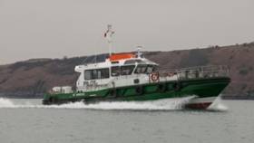
#NewPilotCutters -The first of three 19m pilot boats built by Mainstay Marine Solutions, St. Brides, has been delivered to the Port of Milford Haven in south-west Wales.

The new craft was officially blessed last Thursday by Father Harri Williams of St Katherine’s and St Peter’s Church, before coming into full service.

The 48 tonne vessel is of a similar design to the ‘Picton’ pilot boat delivered to the Port in 2009. Designed by Camarc Design, these vessels have proven reliability of service over many years in the challenging sea conditions which can be found in and around the Port of Milford Haven.

Capable of reaching up to 14 knots with 12 persons on board, the crafts are designed to be used extensively in heavy weather and are likely to operate in swells up to 5m in wave height. They are able to withstand the impact of coming alongside large tankers in turbulent sea conditions and provide a safe platform when transferring pilots to and from ships visiting the various terminals along the Milford Haven Waterway. The boats are fully equipped with the latest safety and operational features and meet the highest standards of reliability and crew safety.

Alec Don, Chief Executive of the Port of Milford Haven, said: “This substantial investment of over £3.6 million in the complete renewal of our pilot boat fleet will provide the port with three identical, modern, state-of-the-art boats with full interchangeability of parts. These boats, together with our highly skilled and trained crews, constitute the backbone of our ability to provide a safe and reliable service to our customers 24 hours a day, 7 days a week. We have been impressed with the professional design and fabrication service delivered by Mainstay Marine Solutions who have delivered exactly in line with the contract”.

Stewart Graves, Managing Director of Mainstay Marine Solutions, commented: “We pride ourselves on our reputation for quality so the positive feedback on the finish of the St Brides pilot boat has been particularly pleasing. Delivering three vessels in quick succession has been a welcome challenge and we are on track to deliver the remaining two vessels to the Port of Milford Haven on time, and to budget.”

The three new vessels will replace the Port’s current fleet of four, the ‘Skomer’ and ‘Picton’ which were delivered in 2007 and 2009 respectively in readiness for the arrival of LNG, the ‘Portunus’, and the Port’s oldest vessel, the ‘Hakin’, which has been operating on the Haven since the early 1980s.

‘St Brides’ was named following a public competition which attracted almost one hundred entries. A traditional marine naming ceremony will take place for all three vessels later this year.

Published in Ports & Shipping

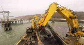
#Dredging - A £1.5m dredging campaign at the Pembrokeshire Port of Milford Haven, to clear the shipping channels and berths has been completed.

The work is an essential part of ensuring the waters leading to and around the terminals on the river remain deep enough for some of the larger ships that use them.

Nearly 180,000 tonnes of fine silt and sand have been cleared from along berths and channels in the port over three months. The dredgers have had to work around several major storms over the period between December and March.
The work formed part of a joint campaign involving the Port of Milford Haven and a number of the other energy companies who operate terminals along the river.

“A campaign on this scale is carried out every ten years,” explained the Port of Milford Haven’s Harbourmaster, Bill Hirst. “It is vital to dredge in order to keep the UK’s biggest energy port open for business. It’s tempting to think a natural harbour such as Milford Haven is always easy to access for even the largest ships. However, the river is constantly depositing material on the seabed. We regularly need to clear out the channels so ships have plenty of room to manoeuver,” Bill continued.

The Port of Milford Haven carries out annual hydrographic surveys of the river bed to monitor build up of silt in the channels. “We have a legal duty to accurately state the depth of waters in the port,” said Bill. “With data going back several years we have a pretty clear idea how often we need to dredge to make sure those stated depths remain accurate.

Several dredging vessels were used to carry out the task. The largest was a 26,000 ton, 150m long ship the Bartolomeu Dias. In order to clear behind terminal jetties, the smaller vessel Mimar Sinan was deployed, equipped with a digging bucket capable of lifting more than 40 tonnes of material in one scoop.

The dredged material is taken to a licensed depositing ground 20 miles offshore.

Published in Dredging
Page 3 of 28

General Information on using Waterways Ireland inland navigations

Safety on the Water

All users of the navigations are strongly recommended to make themselves aware of safety on the water for whatever activity they are involved in and to read the advice offered by the various governing bodies and by:

The Dept. of Transport, Ireland: www.gov.ie/transport and The Maritime and Coastguard Agency, UK, The RNLI – Water Safety Ireland for information in terms of drowning prevention and water safety.

Registration of Vessels

All vessels using the Shannon Navigation, which includes the Shannon-Erne Waterways and the Erne System must be registered with Waterways Ireland. Only open undecked boats with an engine of 15 horsepower or less on the Shannon Navigation, and vessels of 10 horsepower or less on the Erne System, are exempt. Registration is free of charge.

Craft registration should be completed online at: https://www.waterwaysireland.org/online-services/craft-registration

Permits for use of the Grand and Royal Canals and the Barrow Navigation

All vessels using the Grand and Royal Canals and the Barrow Navigation must display appropriate valid Permit(s) i.e A Combined Mooring and Passage Permit (€126) and if not intending to move every five days, an Extended Mooring Permit (€152).

Permit applications should be completed online at: https://www.waterwaysireland.org/online-services/canal-permits

Passage on the Royal and Grand Canals – Dublin Area

For boat passage through the locks east of Lock 12 into / out of Dublin on either the Royal or Grand Canals, Masters are requested to contact the Waterways Ireland Eastern Regional Office (M-F 9.30am-4.30pm) on tel: +353(0)1 868 0148 or email [email protected] prior to making passage in order to plan the necessary lock-keeping assistance arrangements.

On the Grand Canal a minimum of two days notice prior to the planned passage should be given, masters should note that with the exception of pre-arranged events, a maximum of 2 boats per day will be taken through the locks, travelling either east or west.

Movements in or out of the city will be organised by prior arrangement to take place as a single movement in one day. Boaters will be facilitated to travel the system if their passage is considered to be safe by Waterways Ireland and they have the valid permit(s) for mooring and passage.

Newcomen Lifting Bridge

On the Royal Canal two weeks’ notice of bridge passage (Newcomen Lifting Bridge) is required for the pre-set lift date, and lock assistance will then also be arranged. A minimum of 2 boats is required for a bridge lift to go ahead.

Waterways Ireland Eastern Regional Office (Tel: +353(0)1 868 0148 or [email protected] ) is the point of contact for the bridge lift.

A maximum number of boats passing will be implemented to keep to the times given above for the planned lifts (16 for the Sat / Sun lifts & 8 for the weekday lifts). Priority will be given on a first come first served basis.

On day of lift, boaters and passengers must follow guidance from Waterways Ireland staff about sequence of passage under bridge & through Lock 1, and must remain within signed and designated areas.

Events Held on the Waterways

All organised events taking place on the waterways must have the prior approval of Waterways Ireland. This is a twelve week process and application forms must be accompanied with the appropriate insurance, signed indemnity and risk assessment. The application should be completed on the Waterways Ireland events page at :

https://www.waterwaysireland.org/online-services/event-approval

Time Limits on Mooring in Public Harbours

On the Shannon Navigation and the Shannon-Erne Waterway craft may berth in public harbours for five consecutive days or a total of seven days in any one month.

On the Erne System, revised Bye Laws state that: No master or owner shall permit a vessel, boat or any floating or sunken object to remain moored at or in the vicinity of any public mooring, including mooring at any other public mooring within 3 kilometres of that location, for more than 3 consecutive days and shall not moor at that same mooring or any other public mooring within 3 kilometres of that location within the following 3 consecutive days without prior permission by an authorised official.

Winter Mooring on the Shannon Navigation and Shannon Erne Waterway

Winter mooring may be availed of by owners during the period 1 Nov to 31 Mar by prior arrangement and payment of a charge of €63.50 per craft. Craft not availing of Winter Mooring must continue to comply with the “5 Day Rule”. Winter Mooring applications should be completed online at : https://www.waterwaysireland.org/online-services/winter-moorings-booking

Owners should be aware that electricity supply and water supply to public moorings is disconnected for the winter months. This is to protect against frost damage, to reduce running costs and to minimise maintenance requirements during the winter months.

Vessel owners are advised that advance purchasing of electricity on the power bollards leading up to the disconnection date should be minimal. Electricity credit existing on the bollards will not be recoverable after the winter decommissioning date. Both services will be reinstated prior to the commencement of the next boating season.

Smart Cards

Waterways Ireland smart cards are used to operate locks on the Shannon Erne Waterway, to access the service blocks, to use the pump-outs along the navigations, to avail of electrical power at Waterways Ireland jetties.

Berthing in Public Harbours

Masters are reminded of the following:

  • Equip their vessel with mooring lines of appropriate length and strength and only secure their craft to mooring bollards and cleats provided for this purpose.
  • Ensure the available berth is suitable to the length of your vessel, do not overhang the mooring especially on finger moorings on floating pontoon moorings.
  • Ensure mooring lines, electric cables and fresh water hoses do not create a trip hazard on public jetties for others users.
  • Carry sufficient fenders to prevent damage to your own vessel, other vessels and WI property.
  • Allow sufficient space between your vessel and the vessel ahead /astern (c.1m) for fire safety purposes and /or to recover somebody from the water.
  • Do not berth more than two vessels side by side and ensure there is safe access/egress at all times between vessels and onto the harbour itself.
  • Do not berth in such a way to prevent use of harbour safety ladders, slipways or pump-outs.
  • Do not allow the bow of your vessel to overhang the walkway of a floating mooring thus creating a hazard for others with an overhanging anchor or bow fendering.
  • Animals are not allowed to be loose or stray at any time.
  • Harbour and jetty infrastructure such as railings, power pedestals, fresh water taps, electric light poles, safety bollards, ladders etc are not designed for the purpose of mooring craft , they will not bear the strain of a vessel and will be damaged.
  • At Carrybridge on the Erne System, Masters of vessels are not permitted to use stern on mooring. Masters of vessels must use the mooring fingers for mooring of vessels and for embarkation / disembarkation from vessels.

Passenger Vessel Berths

Masters of vessels should not berth on passenger vessel berths where it is indicated that an arrival is imminent. Passenger vessels plying the navigations generally only occupy the berths to embark and disembark passengers and rarely remain on the berths for extended periods or overnight.

Lock Lead-in Jetties

Lead-in jetties adjacent to the upstream and downstream gates at lock chambers are solely for the purpose of craft waiting to use the lock and should not be used for long term berthing.

Vessel Wake

Vessel wake, that is, the wave generated by the passage of the boat through the water, can sometimes be large, powerful and destructive depending on the hull shape and engine power of the vessel. This wake can be detrimental to other users of the navigation when it strikes their craft or inundates the shoreline or riverbank. Masters are requested to frequently look behind and check the effect of their wake / wash particularly when passing moored vessels, on entering harbours and approaching jetties and to be aware of people pursuing other activities such as fishing on the riverbank.

Speed Restriction

A vessel or boat shall not be navigated on the Shannon Navigation at a speed in excess of 5 kph when within 200 metres of a bridge, quay, jetty or wharf, when in a harbour or canal or when passing within 100 metres of a moored vessel or boat.

Vessels navigating the Shannon-Erne Waterway should observe the general 5 kph speed limit which applies along the waterway. This is necessary in order to prevent damage to the banks caused by excessive wash from vessels.

Vessels navigating the Erne System should observe the statutory 5kt / 6mph / 10kph speed limit areas.

A craft on the Royal and Grand canals shall not be navigated at a speed in excess of 6km per hour.

A craft on the Barrow Navigation shall not be navigated at a speed in excess of 11km per hour except as necessary for safe navigation in conditions of fast flow.

Bank Erosion

Narrow sections of all the navigations are particularly prone to bank erosion due to the large wash generated by some craft. Masters are requested to be vigilant and to slow down to a speed sufficient to maintain steerage when they observe the wash of their craft inundating the river banks.

Unusual Waterborne Activity

Unusual waterborne vessels may be encountered from time to time, such as, hovercraft or amphibious aircraft / seaplanes. Masters of such craft are reminded to apply the normal “Rule of the Road” when they meet conventional craft on the water and to allow extra room to manoeuvre in the interest of safety.

Sailing Activity

Mariners will encounter large numbers of sailing dinghies from late June to August in the vicinity of Lough Derg, Lough Ree and Lower Lough Erne. Sailing courses are marked by yellow buoys to suit weather conditions on the day. Vessels should proceed at slow speed and with due caution and observe the rules of navigation when passing these fleets, as many of the participants are junior sailors under training.

Rowing

Mariners should expect to meet canoes and vessels under oars on any part of the navigations, but more so in the vicinity of Athlone, Carrick-on-Shannon, Coleraine, Enniskillen and Limerick. Masters are reminded to proceed at slow speed and especially to reduce their wash to a minimum when passing these craft as they can be easily upset and swamped due to their very low freeboard and always be prepared to give way in any given traffic situation.

Canoeing

Canoeing is an adventure sport and participants are strongly recommended to seek the advice of the sport’s governing bodies i.e Canoeing Ireland and the Canoe Association of Northern Ireland, before venturing onto the navigations.

Persons in charge of canoes are reminded of the inherent danger to these craft associated with operating close to weirs, sluice gates, locks and other infrastructure particularly when rivers are in flood and large volumes of water are moving through the navigations due to general flood conditions or very heavy localised precipitation e.g. turbulent and broken water, stopper waves. Shooting weirs is prohibited without prior permission of Waterways Ireland.

Canoeists should check with lockkeepers prior entering a lock to ensure passage is done in a safe manner. Portage is required at all unmanned locks.

Canoe Trail Network – "Blueways"

Masters of powered craft are reminded that a canoe trail network is being developed across all navigations and to expect more organised canoeing along these trails necessitating slow speed and minimum wash when encountering canoeists, rowing boats etc

Rockingham and Drummans Island Canals – Lough Key

It is expected that work on Rockingham and Drummans Island Canals on Lough Key will be completed in 2021. Access to these canals will be for non-powered craft only, eg canoes, kayaks, rowing boats.

Fast Powerboats and Personal Watercraft (Jet Skis)

Masters of Fast Powerboats (speed greater than 17kts) and Personal Watercraft (i.e.Jet Skis) are reminded of the inherent dangers associated with high speed on the water and especially in the confines of small bays and narrow sections of the navigations. Keeping a proper look-out, making early alterations to course and /or reducing speed will avoid conflict with slower vessels using the navigation. Personal Watercraft are not permitted to be used on the canals.

Towing Waterskiers, Wakeboarders, Doughnuts etc

Masters of vessels engaged in any of these activities are reminded of the manoeuvring constraints imposed upon their vessel by the tow and of the added responsibilities that they have to the person(s) being towed. These activities should be conducted in areas which are clear of conflicting traffic. It is highly recommended that a person additional to the master be carried to act as a “look-out” to keep the tow under observation at all times.

Prohibition on Swimming

Swimming in the navigable channel, particularly at bridges, is dangerous and is prohibited due to the risk of being run over by a vessel underway in the navigation.

Age Restrictions on operating of powered craft

In the Republic of Ireland, Statutory Instrument 921 of 2005 provides the legal requirements regarding the minimum age for operating of powered craft. The Statutory Instrument contains the following requirements:

- The master or owner of a personal watercraft or a fast power craft shall take all reasonable steps to ensure that a person who has not attained the age of 16 years does not operate or control the craft

- The master or owner of a pleasure craft powered by an engine with a rating of more than 5 horse power or 3.7 kilowatts shall take all reasonable steps to ensure that a person who has not attained the age of 12 years does not operate or control the craft.

Lifejackets and Personal Flotation Devices (PFDs)

Lifejackets and PFD’s are the single most important items of personal protective equipment to be used on a vessel and should be worn especially when the vessel is being manoeuvred such as entering / departing a lock, anchoring, coming alongside or departing a jetty or quayside.

In the Republic of Ireland, Statutory Instrument 921 of 2005 provides the legal requirements regarding the wearing of Personal Flotation Devices. The Statutory Instrument contains the following requirements:

- The master or owner of a pleasure craft (other than a personal watercraft) shall ensure, that there are, at all times on board the craft, sufficient suitable personal flotation devices for each person on board.

- A person on a pleasure craft (other than a personal watercraft) of less than 7 metres length overall shall wear a suitable personal flotation device while on board an open craft or while on the deck of decked craft, other than when the craft is made fast to the shore or at anchor.

- The master or owner of a pleasure craft (other than a personal watercraft) shall take all reasonable steps to ensure that a person who has not attained the age of 16 years complies with paragraph above.

- The master or owner of a pleasure craft (other than a personal watercraft), shall take all reasonable steps to ensure that a person who has not attained the age of 16 years wears a suitable personal flotation device while on board an open craft or while on the deck of a decked craft other than when it is made fast to the shore or at anchor.

- The master or owner of a pleasure craft (other than a personal watercraft) shall take all reasonable steps to ensure that a person wears a suitable personal flotation device, at all times while – (a) being towed by the craft, (b) on board a vessel or object of any kind which is being towed by the craft.

Further information is available at: http://www.irishstatutebook.ie/eli/2005/si/921/made/en/print

Firing Range Danger Area – Lough Ree

The attention of mariners is drawn to the Irish Defence Forces Firing Range situated in the vicinity of buoys No’s 2 and 3, on Lough Ree on the Shannon Navigation. This range is used regularly for live firing exercises, throughout the year, all boats and vessels should stay clear of the area marked with yellow buoys showing a yellow "X" topmark and displaying the word "Danger".

Shannon Navigation, Portumna Swing Bridge Tolls

No attempt should be made by Masters’ of vessels to pay the bridge toll while making way through the bridge opening. Payment will only be taken by the Collector from Masters when they are secured alongside the jetties north and south of the bridge.

Navigating from Killaloe to Limerick on the Shannon Navigation

The navigation from Killaloe to Limerick involves passage through Ardnacrusha locks, the associated headrace and tailrace and the Abbey River into Limerick City. Careful passage planning is required to undertake this voyage. Considerations include: lock passage at Ardnacrusha, water flow in the navigation, airdraft under bridges on Abbey River in Limerick, state of tide in Limerick

Users are advised to contact the ESB Ardnacrusha hydroelectric power station (00353 (0)87 9970131) 48 hours in advance of commencing their journey to book passage through the locks at Ardnacrusha. It is NOT advised to undertake a voyage if more than one turbine is operating (20MW), due to the increased velocity of flow in the navigation channel, which can be dangerous. To ascertain automatically in real time how many turbines are running, users can phone +353 (0)87 6477229.

For safety reasons the ESB has advised that only powered craft with a capacity in excess of 5 knots are allowed to enter Ardnacrusha Headrace and Tailrace Canals.

Passage through Sarsfield Lock should be booked on +353-87-7972998, on the day prior to travel and it should be noted also that transit is not possible two hours either side of low water.

A Hydrographic survey in 2020 of the navigation channel revealed that the approach from Shannon Bridge to Sarsfield Lock and the Dock area has silted up. Masters of vessels and water users are advised to navigate to the Lock from Shannon bridge on a rising tide one or two hours before High Tide.

Lower Bann Navigation

The attention of all users is drawn to the “Users Code for the Lower Bann”, in particular to that section covering “Flow in the River” outlining the dangers for users both on the banks and in the navigation, associated with high flow rates when the river is in spate. Canoeists should consult and carry a copy of the “Lower Bann Canoe Trail” guide issued by the Canoe Association of Northern Ireland. Users should also contact the DfI Rivers Coleraine, who is responsible for regulating the flow rates on the river, for advisory information on the flow rates to be expected on any given day.

DfI Rivers Coleraine. Tel: 0044 28 7034 2357 Email: [email protected]

Lower Bann Navigation – Newferry – No wake zone

A No Wake Zone exists on the Lower Bann Navigation at Newferry. Masters of vessels are requested to proceed at a slow speed and create no wake while passing the jetties and slipways at Newferry.

Overhead Power Lines (OHPL) and Air draft

All Masters must be aware of the dangers associated with overhead power lines, in particular sailing vessels and workboats with cranes or large air drafts. Voyage planning is a necessity in order to identify the location of overhead lines crossing the navigation.

Overhead power line heights on the River Shannon are maintained at 12.6metres (40 feet) from Normal Summer level for that section of navigation, masters of vessels with a large air draft should proceed with caution and make additional allowances when water levels are high.

If a vessel or its equipment comes into contact with an OHPL the operator should NOT attempt to move the vessel or equipment. The conductor may still be alive or re-energise automatically. Maintain a safe distance and prevent third parties from approaching due to risk of arcing. Contact the emergency services for assistance.

Anglers are also reminded that a minimum ground distance of 30 metres should be maintained from overhead power lines when using a rod and line.

Submarine Cables and Pipes

Masters of vessels are reminded not to anchor their vessels in the vicinity of submarine cables or pipes in case they foul their anchor or damage the cables or pipes. Look to the river banks for signage indicating their presence.

Water Levels - Precautions

Low Water Levels:

When water levels fall below normal summer levels masters should be aware of:

Navigation

To reduce the risk of grounding masters should navigate on or near the centreline of the channel, avoid short cutting in dog-legged channels and navigating too close to navigation markers.

Proceeding at a slow speed will also reduce “squat” effect i.e. where the vessel tends to sit lower in the water as a consequence of higher speed.

Slipways

Reduced slipway length available under the water surface and the possibility of launching trailers dropping off the end of the concrete apron.

More slipway surface susceptible to weed growth requiring care while engaged in launching boats, from slipping and sliding on the slope. Note also that launching vehicles may not be able to get sufficient traction on the slipway once the craft is launched to get up the incline.

Bank Erosion

Very dry riverbanks are more susceptible to erosion from vessel wash.

Lock Share

Maximising on the number of vessels in a lock will ensure that the total volume of water moving downstream is decreased. Lock cycles should be used for vessels travelling each way.

High Water Levels:

When water levels rise above normal summer level masters should be aware of:

Navigation

Navigation marks will have reduced height above the water level or may disappear underwater altogether making the navigable channel difficult to discern.

In narrow sections of the navigations water levels will tend to rise more quickly than in main streams and air draft at bridges will likewise be reduced.

There will also be increased flow rates particularly in the vicinity of navigation infrastructure such as bridges, weirs, locks etc where extra care in manoeuvring vessels will be required.

Harbours and Jetties

Due care is required in harbours and at slipways when levels are at or near the same level as the harbour walkways' as the edge will be difficult to discern especially in reduced light conditions. It is advised that Personal Flotation Devices be worn if tending to craft in a harbour in these conditions.

Slipways

Slipways should only be used for the purpose of launching and recovering of water craft or other objects from the water. Before using a slipway it should be examined to ensure that the surface has sufficient traction/grip for the intended purpose such as launching a craft from a trailer using a vehicle, that there is sufficient depth of water on the slipway to float the craft off the trailer before the concrete apron ends and that the wheels of the trailer do not drop off the edge of the slipway. That life-saving appliances are available in the vicinity, that the vehicle is roadworthy and capable of coping with the weight of the trailer and boat on the incline. It is recommended that slipway operations are conducted by two persons.

Caution to be Used in Reliance upon Aids to Navigation

The aids to navigation depicted on the navigation guides comprise a system of fixed and floating aids to navigation. Prudent mariners will not rely solely on any single aid to navigation, particularly a floating aid to navigation. With respect to buoys, the buoy symbol is used to indicate the approximate position of the buoy body and the ground tackle which secures it to the lake or river bed. The approximate position is used because of the practical limitations in positioning and maintaining buoys in precise geographical locations. These limitations include, but are not limited to, prevailing atmospheric and lake/river conditions, the slope of and the material making up the lake/river bed, the fact that the buoys are moored to varying lengths of chain, and the fact that the buoy body and/or ground tackle positions are not under continuous surveillance. Due to the forces of nature, the position of the buoy body can be expected to shift inside and outside the charted symbol.

Buoys and perches are also moved out of position or pulled over by those mariners who use them to moor up to instead of anchoring. To this end, mariners should always monitor their passage by relating buoy/perch positions with the published navigation guide. Furthermore, a vessel attempting to pass close by always risks collision with a yawing buoy or with the obstruction that the buoy or beacon/perch marks.

Masters of Vessels are requested to use the most up to date Navigation guides when navigating on the Inland Waterways.

Information taken from Special Marine Notice No 1 of 2023