Menu

Ireland's sailing, boating & maritime magazine

Inland afloat headers


Displaying items by tag: conservation

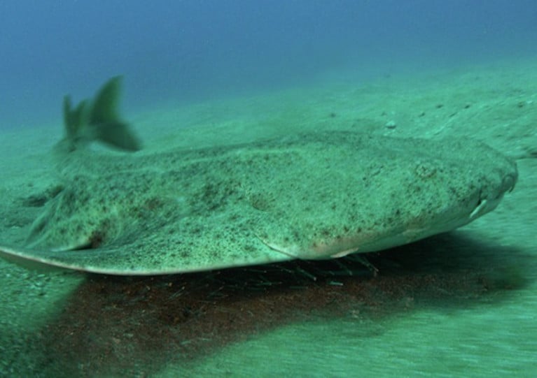
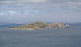
Tralee Bay is a “major nursery” for sharks and rays in Irish waters, says a local marine wildlife expert.

And Kevin Flannery insists the important breeding ground for the likes of angel sharks and porbeagle sharks needs protection.

Marine biologist Flannery, of Dingle OceanWorld, described the little-known nursery off the Kerry coast as “a Serengeti of the Atlantic for rays and sharks”.

And as National Biodiversity Week begins, he’s calling for Tralee Bay to be designated as a marine protected area to provide a safe haven for the many species that lay their eggs there in summer months.

The Irish Mirror has more on the story HERE.

Published in Sharks

Three wildlife trusts in the north-east of England have been boosted with a £300,000 (€345,000) award from a major grantmaking charity for efforts to protect marine wildlife and habitats in the Irish Sea.

As the Chester Standard reports, the Esmée Fairbairn Foundation has given the five-year grant to fund staff carrying out marine policy work and promotion in the north-west region and the wider Irish Sea.

“The funding will enable us to continue our work to protect and lobby for Marine Protected Areas as well as raise awareness about issues affecting our marine life and champion the sustainable management of our seas,” said Martin Varley, operations director with the Cheshire Wildlife Trust.

The grant will also support collaborative work with fellow wildlife trusts in Lancashire and Cumbria, which have already secured public and political support for the designation of 10 Marine Conservation Zones in the Irish Sea.

The Cheshire Standard has much more on the story HERE.

Published in Marine Wildlife

The Minister for Agriculture, Food and the Marine, Michael Creed T.D., today announced that he has approved a new conservation measure that will provide legal protection for v-notched crawfish. The measure received widespread support when the Minister discussed it with industry representatives during today’s meeting of the National Inshore Fisheries Forum (NIFF) at the National Seafood Centre in Clonakilty, Co Cork.

The conservation measure stems from a proposal initiated by members of the fishing industry in the southwest, in consultation with the Marine Institute, which sought legal protection for crawfish v-notched under a Marine Institute project in that region. At today’s NIFF meeting, the Minister also invited the Forum members and the marine agencies to provide their views on an appropriate lead-in period for the new measure.

Commenting on the introduction of the measure, Minister Creed said, “I am pleased to announce the approval of this measure, which has the potential to support the recovery of the crawfish stock in its traditional fishery areas along the South West and West coasts. The Inshore Fisheries Forums, now five years old, continue to embrace the challenge of developing measures to support the sector on the path to long-term sustainability. I have asked my officials to draft the appropriate legal instrument to implement this measure.”

The proposal to protect v-notched crawfish was developed by the North West Kerry Shellfish Co-operative in collaboration with the Marine Institute. It arose from a scientific project carried out over the last two years by the Marine Institute and commercial fishermen targeting crawfish in the southwest. The project, funded by the European Maritime and Fisheries Fund Biodiversity Scheme, seeks biological data on crawfish and investigates crawfish migration.

The proposal was submitted to the South West Regional Inshore Fisheries Forum, which brought it forward to the NIFF for wider industry discussion. The NIFF recommended the proposal to the Minister in January.

The crawfish measure was among a range of inshore fishing issues discussed with industry representatives at the today’s NIFF meeting, which also included implementation of the Inshore Fisheries Sector Strategy as well as proposals for the mackerel hook and line fishery and the management of the landing of crab claws.

Protection of v-notched crawfish

When the legal instrument has been introduced by Minister Creed, it will prohibit Irish sea-fishing boats from landing or retaining on board v-notched crawfish. Such crawfish will need to be returned alive to the sea. It will also prohibit v-notched crawfish from being offered for sale.

A crawfish is ‘v-notched’ through the removal of a v-shaped notch from one of the flaps (known as uropods) either side of the central part of the tail (telson) of a crawfish when it is first caught. A similar provision is in place to protect v-notched lobster under S.I. No. 591 of 2014 (Lobster (Conservation of Stocks) Regulations 2014) and has proved a popular and effective stock management tool.

Published in Fishing
Tagged under

Projects for pearl mussels and conservation of breeding curlew are among the 23 schemes being carried out nationwide under the European Innovation Partnership (EIP), as highlighted in a new exhibition in Dublin.

Agriculture House on Kildare Street is currently showcasing the innovation under the Department of Agriculture, Food and Marine’s EIP/locally led schemes in Ireland.

Speaking at the launch yesterday (Wednesday 17 April), Marine Minister Michael Creed said: “We are committed to building a sustainable agricultural system that respects the environment. The agriculture sector is determined to play its part in responding to the challenges before us on climate, water quality and biodiversity.

“We are investing €59m in these locally-led schemes to achieve these goals at a local level by stimulating and developing innovative new approaches to tackling environmental challenges in a targeted way. This targeted approach to specific challenges in specific areas can complement our larger national agri-environmental schemes.”

The exhibition highlights the varied works undertaken by the EIP Project groups including projects on biodiversity, organic production, pollinators, water quality, flood management, soils, farming in an archaeological landscape and targeting un-utilised agricultural biomass.

The exhibition is open to the public to visit before going nationwide to other DAFM offices for display there. Following its display in Dublin, the exhibition will be moving to the department’s office at Johnstown Castle Estate in Wexford.

Further details of the EIP and locally led schemes can be found on the DAFM website HERE.

Published in Coastal Notes

Inland Fisheries Ireland has announced a new funding call for 2019 with three funding schemes now open to angling clubs and community groups.

The funding has been made available for fisheries conservation projects and development projects nationwide through the National Strategy for Angling Development (NSAD).

Applications are invited from angling clubs, local development associations, tidy towns and others who may be looking to carry out projects.

The 2019 funding call consists of three schemes.

The NSAD Capital Grants Scheme 2019 (€136,000) is aimed specifically at capital improvement works with grants available to groups and individuals looking to improve angling access and infrastructure in their locality.

The Salmon and Sea Trout Rehabilitation, Conservation and Protection Fund focuses on the protection of both salmon and sea trout. It will fund rehabilitation, protection and conservation projects, all of which must focus on salmon or sea trout. This fund replaces the Salmon Conservation Fund and extends it to include both salmon and sea trout with project values starting from €2,000 for awareness projects. The upper limit of €15,000 has been removed.

The Midlands Fisheries Fund (€50,000) will focus on conservation and rehabilitation projects in the midland fisheries permit area. The fund has been created through contributions from the permit income received via the Midlands Fisheries Group permit area.

Sean Canney, Minister of State with responsibility for the inland fisheries sector, said: “Since the inception of the National Strategy for Angling Development, we have invested €3.4 million in fisheries development, protection and conservation projects across the country.

“Progress is being made in the delivery of projects which support vital fisheries conservation and rehabilitation and which enhance Ireland’s angling offering. The fisheries resource should be enjoyed by all and this funding call today once more will help bring angling to the broader community in a conservation focused manner.”

Suzanne Campion of IFI said it looks forward to working with community groups from application to delivery stage on their projects.

“We are already partnering with over a hundred clubs and associations in the delivery of fisheries projects. The commitment of these groups in making a valuable difference to their locality is inspiring.”

For more information about the 2019 funding call, to download an information booklet and to submit an Expression of Interest, visit www.fisheriesireland.ie/funding.

All applicants must apply through the Expression of Interest, which opens today (Tuesday 16 April), to progress to full application. Full applications may be submitted from Monday 20 May with the closing date for applications on Thursday 20 June.

IFI will be hosting information workshops over the coming weeks for those looking for further information or support with the application process:

  • Dublin — Citywest Hotel — Monday 29 April
  • Cavan — Cavan Crystal Hotel — Tuesday 30 April
  • Donegal — Harvey’s Point — Wednesday 1 May
  • Ballina — The Great National Hotel — Thursday 2 May
  • Galway — Maldron Hotel, Oranmore — Friday 3 May
  • Limerick — Maldron Hotel — Tuesday 7 May
  • Tralee — Ballygarry Hotel — Wednesday 8 May
  • Cork City — Rochestown Park Hotel — Thursday 9 May
  • Kilkenny — Ormonde Hotel — Friday 10 May
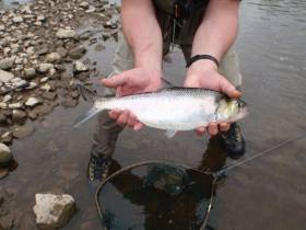
Published in Angling

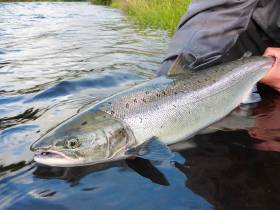
Anglers are needed as citizen scientists for a new National Salmon Scale Project, says Sean Canney TD, Minister of State with responsibility for the inland fisheries sector.

Minister Canney said: “As we celebrate International Year of the Salmon, this project will help researchers understand the challenges which salmon are facing today.

“The project, which has been initiated by Inland Fisheries Ireland, aims to collect vital information through scales taken from salmon and sea trout which are caught in Irish rivers and lakes and will contribute to international efforts to conserve wild salmon.”

Fish scales record the life history of a salmon, and one scale can reveal a lot about the lifestyle and behaviour of the fish.

Scales can tell scientists what age the fish is, how many winters it spent at sea, how many times it spawned, how slow or fast it grew, what it ate and how long it spent in the river before it went out to sea.

Scales can also reveal the general feeding area where the salmon travelled to in the ocean, whether it went to the Faroe Islands, the Norwegian Sea or all the way to West Greenland. Scales help scientists to understand the biology and ecology of Irish salmon and sea trout.

As part of the project, anglers are asked to take a scale sample from a salmon or sea trout by gently scraping and removing approximately 20 fish scales using a clean knife, then post their samples to Inland Fisheries Ireland (IFI) using the sample envelopes which will be made available to them.

Scales can be removed from both harvested and catch-and-release fish. Sampling of fish for release should be handled carefully and fish should be only briefly removed from the water with every effort made to avoid injury or stress while weight should be estimated.

Information from salmon scales is used in setting conservation limits for Irish rivers. Conservation limits for each river are set based on the proportion of salmon who have spent one winter at sea and those that have spent multiple winters at sea.

The conservation limit for a river represents the number of spawning salmon required to produce the next generation of salmon and this information helps inform angling regulations and management. Information from scales on multi-sea winter salmon entering rivers in spring is also important for managing individual river stocks.

Dr Paddy Gargan, senior research officer at IFI, said: “It is important to have anglers collecting scales as they can provide broad coverage across Ireland and collect scales throughout the fishing season.

“A scale resource which includes many different river systems in Ireland over several years is a great asset from a research perspective as it allows us to examine the factors affecting salmon survival at sea. We can compare how factors, such as climate change, are impacting survival by analysing today’s salmon scales alongside those from many decades ago.”

All scales collected through the National Salmon Scale Project will be added to the National Salmon Scale Archive which is managed by IFI.

The archive, which consists of a dedicated storage facility and associated database, currently holds 19,300 scale samples from a total of 38 rivers representing 152 sampling years. The National Salmon Scale Project aims to increase the scale resource available to scientists for ongoing and future research.

IFI’s head of research and development Dr Cathal Gallagher said: “Ultimately the National Salmon Scale Project will help inform future salmon management policies and activities.

“It is fitting therefore that we are launching this campaign during International Year of the Salmon which aims to raise awareness of what humans can do to ensure salmon and their habitats are conserved and restored against a backdrop of several environmental pressures. This project offers anglers a very tangible and practical way of playing an active role in salmon conservation.”

For more information on the National Salmon Scale Project, including how to take a sample safely and to request sample envelopes, visit the project webpage. To find out more about International Year of the Salmon visit YearOfTheSalmon.org.

Published in Angling

#MarineWildlife - A new project which aims to promote international action and co-operation to conserve vulnerable migratory fish species launched yesterday, Thursday 28 March.

The DiadES initiative will see 30 partners from different countries participate in this European project, with Inland Fisheries Ireland (IFI) leading out on the project in Ireland.

The project launches as migratory fish and their habitats continue to come under pressure as a result of human activity and climate change.

It will focus on fish such as shads, lampreys, salmon, trout and mullet which are known as ‘diadromous’ fish as they migrate between fresh and salt waters to reproduce or feed.

The DiadES initiative intends to improve knowledge of the ecological, economic and cultural benefits offered by these migratory species while assessing the possibility of these species changing their locations due to climate change.

It will also examine the emergence of new interactions between fish territories as a result of these relocations.

In addition to collaboration across research and knowledge sharing between countries, the project will take a global multidisciplinary approach.

It will focus on several species across different geographical areas and involve researchers in the field of natural sciences and environmental economists as well as an experienced network of fish managers.

As part of the research, a transnational interactive atlas will be produced which will outline the current distribution of diadromous fish and how they help the ecosystem. This will forecast trends in the geographical distribution of various species and look at possible redistribution of some species as a result of climate change.

The programme will also design a platform for stakeholders to explore different management strategies.

Dr Cathal Gallagher, head of research and development at IFI, said: “Throughout their life cycle, diadromous fish provide ‘ecosystem services’. This means they provide food, regulate and support the ecosystem through the nutrient cycle and offer a recreational pursuit to local communities. All of these fish generate significant ecological, economic and cultural benefits for local communities across Europe.

“We are keen to play our role in assessing and enhancing the role these fish play while also assisting them as they navigate the effects of climate change which has resulted in a reduction in their distribution.”

The DiadES project is led by the French research institute Irstea and is financed by the Interreg Atlantic Area Programme of the European Regional Development Fund (ERDF) to the value of €2.2 million.
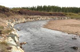
Published in Marine Science

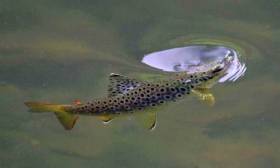
#Angling - Submissions are now open in a public consultation hosted by Inland Fisheries Ireland (IFI) around a proposed angling bye-law which focuses on the conservation of sea trout and brown trout on the River Bandon.

The new bye-law aims to help conserve the numbers of brown trout of all sizes taken from upstream areas of the river and its tributaries, as well as the numbers of young sea trout taken in the lower river and upper estuary.

There is currently no minimum length size specified when catching and retaining a sea trout or brown trout on the river. In addition, there is no ‘bag limit’ on the number of brown trout an angler can retain.

The new bye-law would set a minimum length of 25 centimetres for any sea trout or any brown trout caught and retained on the waters of the River Bandon and its tributaries, and a bag limit of not more than three brown trout per day on the waters of the River Bandon and its tributaries.

The bye-law would also require anglers to fish by catch-and-release methods, ban the use of worms, and allow only single barbless hooks in angling for brown trout once the three per-day bag limit had been reached.

Interested parties should make a submission to the consultation in writing. Submissions should be marked ‘Public consultation – River Bandon (Conservation of Trout)’ and be submitted by post to Inland Fisheries Ireland, Sunnyside House, Macroom, Co Cork, P12 X602 or by email to [email protected].

The deadline for receipt of submissions is 5pm on Monday 31 December. All submissions received by IFI will be published on its website at www.fisheriesireland.ie.

Published in Angling

#MarineWildlife - A Howth-based ferryman fears for marine wildlife on and around Ireland’s Eye when a planned sewage outfall pipe begins discharging wastewater in the area.

Ken Doyle of Ireland’s Eye Ferries tells Dublin Live that any accidental contamination of the waters from the pipeline, from Clonshaugh to a mile off the small island immediately north of Howth, could have a disastrous knock-on effect on fish stocks — an issue both for sea anglers and local bird and seal colonies.

Five years ago, Clonshaugh in North Co Dublin was chosen as the location for the capital’s wastewater treatment ‘super plant’.

The scheme will connect a 26km orbital sewer through counties Dublin, Kildare and Meath with an outfall pipeline ejecting waste off Ireland’s Eye.

Doyle noted that when the outflow of raw sewage at Howth Head was ended with the opening of the Ringsend treatment plant, improvements in water quality meant “the bird population increased hugely and it’s all positive but I wouldn’t like it to go back to like it was.”

He adds that he is not opposed to the wastewater scheme in principle — only that he and other local residents and businesses want assurances that the plant will not have any negative impact on the environment.

Dublin Live has much more on the story HERE.

Published in Marine Wildlife

#MarineWildlife - Basking sharks, stingrays and seaweeds are among nearly 50 species of marine flora and fauna faced with extinction in Ireland’s waters, according to a new report from the Irish Wildlife Trust (IWT).

Protecting Our Ocean Wealth outlines the current conservation status of 48 species considered most vulnerable due to a lack of comprehensive legislation to protect their habitats.

The IWT report proposes a number of measures that could assist in conversation, including new legal protections for certain species sought after in sport angling, and the closing of the crawfish fishery in Tralee Bay to help restore an “entire ecosystem”.

But as The Irish Times reports, it’s feared that a number of species, including halibut, wolf-fish and the common sturgeon, may already have vanished from Irish waters. More on the story HERE.

Published in Marine Wildlife
Page 2 of 7

General Information on using Waterways Ireland inland navigations

Safety on the Water

All users of the navigations are strongly recommended to make themselves aware of safety on the water for whatever activity they are involved in and to read the advice offered by the various governing bodies and by:

The Dept. of Transport, Ireland: www.gov.ie/transport and The Maritime and Coastguard Agency, UK, The RNLI – Water Safety Ireland for information in terms of drowning prevention and water safety.

Registration of Vessels

All vessels using the Shannon Navigation, which includes the Shannon-Erne Waterways and the Erne System must be registered with Waterways Ireland. Only open undecked boats with an engine of 15 horsepower or less on the Shannon Navigation, and vessels of 10 horsepower or less on the Erne System, are exempt. Registration is free of charge.

Craft registration should be completed online at: https://www.waterwaysireland.org/online-services/craft-registration

Permits for use of the Grand and Royal Canals and the Barrow Navigation

All vessels using the Grand and Royal Canals and the Barrow Navigation must display appropriate valid Permit(s) i.e A Combined Mooring and Passage Permit (€126) and if not intending to move every five days, an Extended Mooring Permit (€152).

Permit applications should be completed online at: https://www.waterwaysireland.org/online-services/canal-permits

Passage on the Royal and Grand Canals – Dublin Area

For boat passage through the locks east of Lock 12 into / out of Dublin on either the Royal or Grand Canals, Masters are requested to contact the Waterways Ireland Eastern Regional Office (M-F 9.30am-4.30pm) on tel: +353(0)1 868 0148 or email [email protected] prior to making passage in order to plan the necessary lock-keeping assistance arrangements.

On the Grand Canal a minimum of two days notice prior to the planned passage should be given, masters should note that with the exception of pre-arranged events, a maximum of 2 boats per day will be taken through the locks, travelling either east or west.

Movements in or out of the city will be organised by prior arrangement to take place as a single movement in one day. Boaters will be facilitated to travel the system if their passage is considered to be safe by Waterways Ireland and they have the valid permit(s) for mooring and passage.

Newcomen Lifting Bridge

On the Royal Canal two weeks’ notice of bridge passage (Newcomen Lifting Bridge) is required for the pre-set lift date, and lock assistance will then also be arranged. A minimum of 2 boats is required for a bridge lift to go ahead.

Waterways Ireland Eastern Regional Office (Tel: +353(0)1 868 0148 or [email protected] ) is the point of contact for the bridge lift.

A maximum number of boats passing will be implemented to keep to the times given above for the planned lifts (16 for the Sat / Sun lifts & 8 for the weekday lifts). Priority will be given on a first come first served basis.

On day of lift, boaters and passengers must follow guidance from Waterways Ireland staff about sequence of passage under bridge & through Lock 1, and must remain within signed and designated areas.

Events Held on the Waterways

All organised events taking place on the waterways must have the prior approval of Waterways Ireland. This is a twelve week process and application forms must be accompanied with the appropriate insurance, signed indemnity and risk assessment. The application should be completed on the Waterways Ireland events page at :

https://www.waterwaysireland.org/online-services/event-approval

Time Limits on Mooring in Public Harbours

On the Shannon Navigation and the Shannon-Erne Waterway craft may berth in public harbours for five consecutive days or a total of seven days in any one month.

On the Erne System, revised Bye Laws state that: No master or owner shall permit a vessel, boat or any floating or sunken object to remain moored at or in the vicinity of any public mooring, including mooring at any other public mooring within 3 kilometres of that location, for more than 3 consecutive days and shall not moor at that same mooring or any other public mooring within 3 kilometres of that location within the following 3 consecutive days without prior permission by an authorised official.

Winter Mooring on the Shannon Navigation and Shannon Erne Waterway

Winter mooring may be availed of by owners during the period 1 Nov to 31 Mar by prior arrangement and payment of a charge of €63.50 per craft. Craft not availing of Winter Mooring must continue to comply with the “5 Day Rule”. Winter Mooring applications should be completed online at : https://www.waterwaysireland.org/online-services/winter-moorings-booking

Owners should be aware that electricity supply and water supply to public moorings is disconnected for the winter months. This is to protect against frost damage, to reduce running costs and to minimise maintenance requirements during the winter months.

Vessel owners are advised that advance purchasing of electricity on the power bollards leading up to the disconnection date should be minimal. Electricity credit existing on the bollards will not be recoverable after the winter decommissioning date. Both services will be reinstated prior to the commencement of the next boating season.

Smart Cards

Waterways Ireland smart cards are used to operate locks on the Shannon Erne Waterway, to access the service blocks, to use the pump-outs along the navigations, to avail of electrical power at Waterways Ireland jetties.

Berthing in Public Harbours

Masters are reminded of the following:

  • Equip their vessel with mooring lines of appropriate length and strength and only secure their craft to mooring bollards and cleats provided for this purpose.
  • Ensure the available berth is suitable to the length of your vessel, do not overhang the mooring especially on finger moorings on floating pontoon moorings.
  • Ensure mooring lines, electric cables and fresh water hoses do not create a trip hazard on public jetties for others users.
  • Carry sufficient fenders to prevent damage to your own vessel, other vessels and WI property.
  • Allow sufficient space between your vessel and the vessel ahead /astern (c.1m) for fire safety purposes and /or to recover somebody from the water.
  • Do not berth more than two vessels side by side and ensure there is safe access/egress at all times between vessels and onto the harbour itself.
  • Do not berth in such a way to prevent use of harbour safety ladders, slipways or pump-outs.
  • Do not allow the bow of your vessel to overhang the walkway of a floating mooring thus creating a hazard for others with an overhanging anchor or bow fendering.
  • Animals are not allowed to be loose or stray at any time.
  • Harbour and jetty infrastructure such as railings, power pedestals, fresh water taps, electric light poles, safety bollards, ladders etc are not designed for the purpose of mooring craft , they will not bear the strain of a vessel and will be damaged.
  • At Carrybridge on the Erne System, Masters of vessels are not permitted to use stern on mooring. Masters of vessels must use the mooring fingers for mooring of vessels and for embarkation / disembarkation from vessels.

Passenger Vessel Berths

Masters of vessels should not berth on passenger vessel berths where it is indicated that an arrival is imminent. Passenger vessels plying the navigations generally only occupy the berths to embark and disembark passengers and rarely remain on the berths for extended periods or overnight.

Lock Lead-in Jetties

Lead-in jetties adjacent to the upstream and downstream gates at lock chambers are solely for the purpose of craft waiting to use the lock and should not be used for long term berthing.

Vessel Wake

Vessel wake, that is, the wave generated by the passage of the boat through the water, can sometimes be large, powerful and destructive depending on the hull shape and engine power of the vessel. This wake can be detrimental to other users of the navigation when it strikes their craft or inundates the shoreline or riverbank. Masters are requested to frequently look behind and check the effect of their wake / wash particularly when passing moored vessels, on entering harbours and approaching jetties and to be aware of people pursuing other activities such as fishing on the riverbank.

Speed Restriction

A vessel or boat shall not be navigated on the Shannon Navigation at a speed in excess of 5 kph when within 200 metres of a bridge, quay, jetty or wharf, when in a harbour or canal or when passing within 100 metres of a moored vessel or boat.

Vessels navigating the Shannon-Erne Waterway should observe the general 5 kph speed limit which applies along the waterway. This is necessary in order to prevent damage to the banks caused by excessive wash from vessels.

Vessels navigating the Erne System should observe the statutory 5kt / 6mph / 10kph speed limit areas.

A craft on the Royal and Grand canals shall not be navigated at a speed in excess of 6km per hour.

A craft on the Barrow Navigation shall not be navigated at a speed in excess of 11km per hour except as necessary for safe navigation in conditions of fast flow.

Bank Erosion

Narrow sections of all the navigations are particularly prone to bank erosion due to the large wash generated by some craft. Masters are requested to be vigilant and to slow down to a speed sufficient to maintain steerage when they observe the wash of their craft inundating the river banks.

Unusual Waterborne Activity

Unusual waterborne vessels may be encountered from time to time, such as, hovercraft or amphibious aircraft / seaplanes. Masters of such craft are reminded to apply the normal “Rule of the Road” when they meet conventional craft on the water and to allow extra room to manoeuvre in the interest of safety.

Sailing Activity

Mariners will encounter large numbers of sailing dinghies from late June to August in the vicinity of Lough Derg, Lough Ree and Lower Lough Erne. Sailing courses are marked by yellow buoys to suit weather conditions on the day. Vessels should proceed at slow speed and with due caution and observe the rules of navigation when passing these fleets, as many of the participants are junior sailors under training.

Rowing

Mariners should expect to meet canoes and vessels under oars on any part of the navigations, but more so in the vicinity of Athlone, Carrick-on-Shannon, Coleraine, Enniskillen and Limerick. Masters are reminded to proceed at slow speed and especially to reduce their wash to a minimum when passing these craft as they can be easily upset and swamped due to their very low freeboard and always be prepared to give way in any given traffic situation.

Canoeing

Canoeing is an adventure sport and participants are strongly recommended to seek the advice of the sport’s governing bodies i.e Canoeing Ireland and the Canoe Association of Northern Ireland, before venturing onto the navigations.

Persons in charge of canoes are reminded of the inherent danger to these craft associated with operating close to weirs, sluice gates, locks and other infrastructure particularly when rivers are in flood and large volumes of water are moving through the navigations due to general flood conditions or very heavy localised precipitation e.g. turbulent and broken water, stopper waves. Shooting weirs is prohibited without prior permission of Waterways Ireland.

Canoeists should check with lockkeepers prior entering a lock to ensure passage is done in a safe manner. Portage is required at all unmanned locks.

Canoe Trail Network – "Blueways"

Masters of powered craft are reminded that a canoe trail network is being developed across all navigations and to expect more organised canoeing along these trails necessitating slow speed and minimum wash when encountering canoeists, rowing boats etc

Rockingham and Drummans Island Canals – Lough Key

It is expected that work on Rockingham and Drummans Island Canals on Lough Key will be completed in 2021. Access to these canals will be for non-powered craft only, eg canoes, kayaks, rowing boats.

Fast Powerboats and Personal Watercraft (Jet Skis)

Masters of Fast Powerboats (speed greater than 17kts) and Personal Watercraft (i.e.Jet Skis) are reminded of the inherent dangers associated with high speed on the water and especially in the confines of small bays and narrow sections of the navigations. Keeping a proper look-out, making early alterations to course and /or reducing speed will avoid conflict with slower vessels using the navigation. Personal Watercraft are not permitted to be used on the canals.

Towing Waterskiers, Wakeboarders, Doughnuts etc

Masters of vessels engaged in any of these activities are reminded of the manoeuvring constraints imposed upon their vessel by the tow and of the added responsibilities that they have to the person(s) being towed. These activities should be conducted in areas which are clear of conflicting traffic. It is highly recommended that a person additional to the master be carried to act as a “look-out” to keep the tow under observation at all times.

Prohibition on Swimming

Swimming in the navigable channel, particularly at bridges, is dangerous and is prohibited due to the risk of being run over by a vessel underway in the navigation.

Age Restrictions on operating of powered craft

In the Republic of Ireland, Statutory Instrument 921 of 2005 provides the legal requirements regarding the minimum age for operating of powered craft. The Statutory Instrument contains the following requirements:

- The master or owner of a personal watercraft or a fast power craft shall take all reasonable steps to ensure that a person who has not attained the age of 16 years does not operate or control the craft

- The master or owner of a pleasure craft powered by an engine with a rating of more than 5 horse power or 3.7 kilowatts shall take all reasonable steps to ensure that a person who has not attained the age of 12 years does not operate or control the craft.

Lifejackets and Personal Flotation Devices (PFDs)

Lifejackets and PFD’s are the single most important items of personal protective equipment to be used on a vessel and should be worn especially when the vessel is being manoeuvred such as entering / departing a lock, anchoring, coming alongside or departing a jetty or quayside.

In the Republic of Ireland, Statutory Instrument 921 of 2005 provides the legal requirements regarding the wearing of Personal Flotation Devices. The Statutory Instrument contains the following requirements:

- The master or owner of a pleasure craft (other than a personal watercraft) shall ensure, that there are, at all times on board the craft, sufficient suitable personal flotation devices for each person on board.

- A person on a pleasure craft (other than a personal watercraft) of less than 7 metres length overall shall wear a suitable personal flotation device while on board an open craft or while on the deck of decked craft, other than when the craft is made fast to the shore or at anchor.

- The master or owner of a pleasure craft (other than a personal watercraft) shall take all reasonable steps to ensure that a person who has not attained the age of 16 years complies with paragraph above.

- The master or owner of a pleasure craft (other than a personal watercraft), shall take all reasonable steps to ensure that a person who has not attained the age of 16 years wears a suitable personal flotation device while on board an open craft or while on the deck of a decked craft other than when it is made fast to the shore or at anchor.

- The master or owner of a pleasure craft (other than a personal watercraft) shall take all reasonable steps to ensure that a person wears a suitable personal flotation device, at all times while – (a) being towed by the craft, (b) on board a vessel or object of any kind which is being towed by the craft.

Further information is available at: http://www.irishstatutebook.ie/eli/2005/si/921/made/en/print

Firing Range Danger Area – Lough Ree

The attention of mariners is drawn to the Irish Defence Forces Firing Range situated in the vicinity of buoys No’s 2 and 3, on Lough Ree on the Shannon Navigation. This range is used regularly for live firing exercises, throughout the year, all boats and vessels should stay clear of the area marked with yellow buoys showing a yellow "X" topmark and displaying the word "Danger".

Shannon Navigation, Portumna Swing Bridge Tolls

No attempt should be made by Masters’ of vessels to pay the bridge toll while making way through the bridge opening. Payment will only be taken by the Collector from Masters when they are secured alongside the jetties north and south of the bridge.

Navigating from Killaloe to Limerick on the Shannon Navigation

The navigation from Killaloe to Limerick involves passage through Ardnacrusha locks, the associated headrace and tailrace and the Abbey River into Limerick City. Careful passage planning is required to undertake this voyage. Considerations include: lock passage at Ardnacrusha, water flow in the navigation, airdraft under bridges on Abbey River in Limerick, state of tide in Limerick

Users are advised to contact the ESB Ardnacrusha hydroelectric power station (00353 (0)87 9970131) 48 hours in advance of commencing their journey to book passage through the locks at Ardnacrusha. It is NOT advised to undertake a voyage if more than one turbine is operating (20MW), due to the increased velocity of flow in the navigation channel, which can be dangerous. To ascertain automatically in real time how many turbines are running, users can phone +353 (0)87 6477229.

For safety reasons the ESB has advised that only powered craft with a capacity in excess of 5 knots are allowed to enter Ardnacrusha Headrace and Tailrace Canals.

Passage through Sarsfield Lock should be booked on +353-87-7972998, on the day prior to travel and it should be noted also that transit is not possible two hours either side of low water.

A Hydrographic survey in 2020 of the navigation channel revealed that the approach from Shannon Bridge to Sarsfield Lock and the Dock area has silted up. Masters of vessels and water users are advised to navigate to the Lock from Shannon bridge on a rising tide one or two hours before High Tide.

Lower Bann Navigation

The attention of all users is drawn to the “Users Code for the Lower Bann”, in particular to that section covering “Flow in the River” outlining the dangers for users both on the banks and in the navigation, associated with high flow rates when the river is in spate. Canoeists should consult and carry a copy of the “Lower Bann Canoe Trail” guide issued by the Canoe Association of Northern Ireland. Users should also contact the DfI Rivers Coleraine, who is responsible for regulating the flow rates on the river, for advisory information on the flow rates to be expected on any given day.

DfI Rivers Coleraine. Tel: 0044 28 7034 2357 Email: [email protected]

Lower Bann Navigation – Newferry – No wake zone

A No Wake Zone exists on the Lower Bann Navigation at Newferry. Masters of vessels are requested to proceed at a slow speed and create no wake while passing the jetties and slipways at Newferry.

Overhead Power Lines (OHPL) and Air draft

All Masters must be aware of the dangers associated with overhead power lines, in particular sailing vessels and workboats with cranes or large air drafts. Voyage planning is a necessity in order to identify the location of overhead lines crossing the navigation.

Overhead power line heights on the River Shannon are maintained at 12.6metres (40 feet) from Normal Summer level for that section of navigation, masters of vessels with a large air draft should proceed with caution and make additional allowances when water levels are high.

If a vessel or its equipment comes into contact with an OHPL the operator should NOT attempt to move the vessel or equipment. The conductor may still be alive or re-energise automatically. Maintain a safe distance and prevent third parties from approaching due to risk of arcing. Contact the emergency services for assistance.

Anglers are also reminded that a minimum ground distance of 30 metres should be maintained from overhead power lines when using a rod and line.

Submarine Cables and Pipes

Masters of vessels are reminded not to anchor their vessels in the vicinity of submarine cables or pipes in case they foul their anchor or damage the cables or pipes. Look to the river banks for signage indicating their presence.

Water Levels - Precautions

Low Water Levels:

When water levels fall below normal summer levels masters should be aware of:

Navigation

To reduce the risk of grounding masters should navigate on or near the centreline of the channel, avoid short cutting in dog-legged channels and navigating too close to navigation markers.

Proceeding at a slow speed will also reduce “squat” effect i.e. where the vessel tends to sit lower in the water as a consequence of higher speed.

Slipways

Reduced slipway length available under the water surface and the possibility of launching trailers dropping off the end of the concrete apron.

More slipway surface susceptible to weed growth requiring care while engaged in launching boats, from slipping and sliding on the slope. Note also that launching vehicles may not be able to get sufficient traction on the slipway once the craft is launched to get up the incline.

Bank Erosion

Very dry riverbanks are more susceptible to erosion from vessel wash.

Lock Share

Maximising on the number of vessels in a lock will ensure that the total volume of water moving downstream is decreased. Lock cycles should be used for vessels travelling each way.

High Water Levels:

When water levels rise above normal summer level masters should be aware of:

Navigation

Navigation marks will have reduced height above the water level or may disappear underwater altogether making the navigable channel difficult to discern.

In narrow sections of the navigations water levels will tend to rise more quickly than in main streams and air draft at bridges will likewise be reduced.

There will also be increased flow rates particularly in the vicinity of navigation infrastructure such as bridges, weirs, locks etc where extra care in manoeuvring vessels will be required.

Harbours and Jetties

Due care is required in harbours and at slipways when levels are at or near the same level as the harbour walkways' as the edge will be difficult to discern especially in reduced light conditions. It is advised that Personal Flotation Devices be worn if tending to craft in a harbour in these conditions.

Slipways

Slipways should only be used for the purpose of launching and recovering of water craft or other objects from the water. Before using a slipway it should be examined to ensure that the surface has sufficient traction/grip for the intended purpose such as launching a craft from a trailer using a vehicle, that there is sufficient depth of water on the slipway to float the craft off the trailer before the concrete apron ends and that the wheels of the trailer do not drop off the edge of the slipway. That life-saving appliances are available in the vicinity, that the vehicle is roadworthy and capable of coping with the weight of the trailer and boat on the incline. It is recommended that slipway operations are conducted by two persons.

Caution to be Used in Reliance upon Aids to Navigation

The aids to navigation depicted on the navigation guides comprise a system of fixed and floating aids to navigation. Prudent mariners will not rely solely on any single aid to navigation, particularly a floating aid to navigation. With respect to buoys, the buoy symbol is used to indicate the approximate position of the buoy body and the ground tackle which secures it to the lake or river bed. The approximate position is used because of the practical limitations in positioning and maintaining buoys in precise geographical locations. These limitations include, but are not limited to, prevailing atmospheric and lake/river conditions, the slope of and the material making up the lake/river bed, the fact that the buoys are moored to varying lengths of chain, and the fact that the buoy body and/or ground tackle positions are not under continuous surveillance. Due to the forces of nature, the position of the buoy body can be expected to shift inside and outside the charted symbol.

Buoys and perches are also moved out of position or pulled over by those mariners who use them to moor up to instead of anchoring. To this end, mariners should always monitor their passage by relating buoy/perch positions with the published navigation guide. Furthermore, a vessel attempting to pass close by always risks collision with a yawing buoy or with the obstruction that the buoy or beacon/perch marks.

Masters of Vessels are requested to use the most up to date Navigation guides when navigating on the Inland Waterways.

Information taken from Special Marine Notice No 1 of 2023