Menu

Ireland's sailing, boating & maritime magazine

Inland afloat headers


Displaying items by tag: iPhone

#INLAND WATERWAYS - A new mobile app that guides visitors around the trails of Lough Derg has gone live, the Clare Champion reports.

More than 20 trails are included in the app, from walking to cycling, driving, cruising and canoeing.

The app - developed in partnership between Shannon Development and US firm EveryTrail - uses Google Maps and the GPS system in smartphones to pinpoint trails near the user's location.

Users can download route descriptions, images and notes, get directions to the starting point and follow the the pre-plotted course.

The Lough Derg Trails app is available for iPhone and Android devices.

The Clare Champion has more on the story HERE.

Published in Inland Waterways

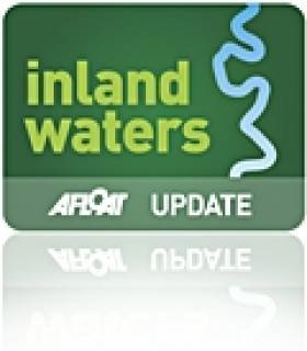
Dag Pike talks us through the fact the ubiquitous IPhone will do nearly anything that you ask it to and it even makes phone calls. Much of what it does is related to land-based applications but now the boundaries are becoming blurred and the IPhone can become a wonderful navigation device for use at sea.

I am sure that many of you have already discovered the virtues of the IPhone and the more I use it for navigation, the more I discover what it will do. The problem is to narrow down what you want the phone to do rather than being distracted by the wide variety of applications on offer that will run your life if you let them.

dagnav

Certainly the IPhone is the most complete navigation tool ever invented. In one tiny unit, it offers communication, navigation charting and positioning, compass, tides and currents, AIS, and even a log book, all at the touch of a button. As far as I can work out, there are only two things missing from the navigation repertoire of the IPhone. One is radar, and there really is no way around that one, and the second is a depth sounder and the only way that you might get that information from the IPhone would be to tie it onto a piece of string and drop it overboard! Everything or at least nearly everything else you might need for navigation is contained in the one small portable package.

It sounds too good to be true and in some ways it is. Being a small portable package makes it vulnerable. You might drop it, you might loose it, you might have a flat battery, or it might just stop working, so you could be vulnerable if you put all your trust into this one unit. For many, there has been safety in the philosophy of having each navigation requirement contained in a separate unit, then if one fails then you still have the other to keep you going. I would be very nervous about putting all my navigation requirements into the one IPhone when I was out at sea but where the IPhone would perform very well would be as a back-up to the conventional navigation systems and it would still remain working if all your electrics failed.

Let's have a closer look at each navigation requirement that can be provided by the IPhone and this will give a better picture of what can and cannot be done with the IPhone.

Communications

You can make phone calls and send text messages and have Internet access using the IPhone wherever there is coverage for the provider that you are using. If you want to get sophisticated, then you need the 3G coverage and that tends to be less extensive, particularly out at sea. For normal phone coverage, you can be pretty certain of coverage up to 5 miles offshore and in many areas up to 10 miles but after that it can be a bit hit and miss. There will always be dead spots that the signal cannot reach, particularly along a rocky coastline where there are cliffs, but this can be a problem with marine VHF as well.

Whilst there are detailed maps showing the mobile phone coverage on land there are none for sea coverage so you can only learn what is available when you are out there. You should have a VHF radio on board as well as an IPhone so that you can hear distress messages and send out your own if you are in trouble but more and more these days boaters are using mobile phones to communicate for routine matters such as organising a berth in a marina and you certainly don't want to be thinking about using the VHF to book a table in a restaurant.

iphone_baltic

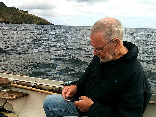
With the Navionics navigation package on your IPhone, I love the way that you can just tap on a port or marina and up will come the telephone number. One more tap on the screen and the phone is ringing.

GPS Reception

GPS is the key to position fixing and the IPhone has a built in receiver that should know where you are all the time. However, you will notice that your conventional chart plotter has its GPS antenna located outside the boat to ensure continuous reception. Your IPhone GPS will have its antenna inside the boat most of the time so you will need to check whether the GPS is working here. It may work under the windscreen and it should certainly work in an open boat or on the flybridge but GPS reception is certainly something to check out before you commit yourself to IPhone navigation. I use the Pocket GPS World App because this shows you the reliability of the position information being produced by the GPS and you should consider this vital information.

There are very cheap or free GPS Apps that you can download that will show your position, speed course etc, which you could use in conjunction with paper charts if you just want to simplify your IPhone navigation.

Navigation

There is no doubt in my mind that that the Navionics App is the best one both for route planning and for navigation itself. This system has rave reviews and it works extremely well by offering most of the facilities that are found on mainstream chart plotters on the small screen of the IPhone. There is virtually worldwide chart coverage and you simply download the App that is relevant to the area you plan to sail in. For instance you can get chart coverage of the whole of the UK and Northern Europe for the price of a couple of bottles of wine.

It is the compact size of the screen that can make things difficult but you soon get used to this. When you are plotting a route, you need to take extra care that the route you have chosen is free from dangers and this can only be done by expanding the scale and then carefully studying the route in detail. I found it too easy to set the waypoints out and then find that the chosen route passes over a rock or a shoal that does not show up too well on the small screen or the scale that you are using.

You set the waypoints by selecting WP and then simply tapping the screen and with big fingers, it is not easy to set them accurately. However, they are easy to adjust, again by simply touching the way point and dragging it to where you want it to be. It took me 5 minutes to plot a route involving 10 waypoints and that including checking it out afterwards.

Once plotted all you need to do is keep the 'own ship' icon on the course line to follow the route. You can set the track plotting mode so that you have a record of where you have been and you get a heading vector and a speed read-out provided that you are doing more than 5 knots. That might be a handicap for sail boats because that heading vector is particularly useful to see where you are going in relation to the plotted route.

Don't take for granted that the GPS plot is giving accurate information. As mentioned above, I like to get a check on the quality of the GPS fix because when I was testing the IPhone, there were a couple of times when it plotted over the land and I was confident that I was on the water.

The Navionics App also has tidal and current information for 7 days ahead for a variety of locations around your position. There is so much information built into the system that you have virtually everything at your fingertips. However, there are some things that it will not do such as showing you the total distance of a route you have plotted and the courses and distances of each leg of the route. That said, the Navionics App has to be one of the most useful for those who want to navigate on the water.

AIS

You cannot get a direct read-out from the AIS transmitters around you because you need VHF for that but the next best thing is the Ship Finder App. With this App you can go to nearly any location around the world and it will show you the ships and boats that are transmitting their AIS signals. Tap on any one of the ship icons and it will show you all the details of the ship including its size, destination and course and speed. This function is more of interest than a serious navigation tool but it could be useful to indentify a ship out at sea and to give some idea of where it might be heading.

Compass

The IPhone has a built-in compass but there are also a number of Apps available with alternative compass displays. The standard display shows both an analogue and a digital read-out of the heading and checking this out at sea, it seems to be reasonably accurate, say to within 5°. The reason it is hard to get better accuracy is that the heading shown is the way that the IPhone is pointing and it is hard to get this lined up exactly with the bow of the boat. It only wants a slight movement of the phone to change the heading by several degrees. However as an emergency compass it works and you have the choice of the readout in either true or magnetic headings.

Weather

If your IPhone is connected to the Internet then you can access all the web sites that offer weather information. However I use an App called Weather Pro that will give you detailed 7 day weather at any port you programme in. The forecast is given for every 3 hours and details thing like wind strength and direction as well as predicted wind gust speeds. However, you do need to be aware that these are basically land forecasts and the conditions at sea could vary a little.

Comments

Every time that I have used the IPhone for navigation I have been amazed at its capabilities. It gives you so much information in such a small package that you will wonder how you ever managed without it. This really is the problem because in time you will take everything the IPhone can do for granted and you will no longer check that it is giving good quality navigation information. The biggest worry is the quality of the GPS position information because much of the navigation depends on this. I used the App that tells you the quality of the GPS fix but that means switching over to this at frequent intervals. It would be much better to have an automatic system that throws up an alarm when the GPS position is poor. I am sure that will come with time.

I would be nervous if the IPhone was my only source of navigation information. It is easily dropped, it is not waterproof and the battery has only a limited life. Of course, you can mount it into a holder and you can keep the charger plugged in to overcome the battery life problem and you can get extra life batteries. Where the IPhone scores is that it makes a great back-up system that will cover most of your navigation needs. In this respect, it could replace the hand held GPS and the hand- held VHF to a certain extent but before you throw these items away, I would suggest that you get a lot of experience with IPhone navigation. Only then will it become the true navigation friend that this remarkable piece of equipment is.

Published in Afloat Guide
Tagged under

A stricken vessel was located in trouble on Lough Erne using lat/long data from an iPhone. 


A 999 call from the Motor Cruiser ‘Wee Rascal’ on Lough Erne in the early hours of this morning called on all the investigative powers of Belfast Coastguard as the vessel wasn’t even close to its reported position.

The vessel was on passage from Kesh to Enniskillen in windy, wet conditions when it called 999 to ask for assistance. Despite an extensive search of the area around its reported position neither the Enniskillen RNLI Inshore Lifeboat nor Erne Coastguard Rescue Teams could find the vessel.

Because the vessel had no flares, flash lights or VHF Radio on board to show rescuers where it was, Belfast Coastguard resorted to mobile phone technology. A locator i-phone application finally gave rescuers the vital latitude and longitude they needed to locate the vessel

The vessel was finally located 25 miles away from its reported position, dangerously amongst the rocky shoreline off Eagle Point. It was carefully brought away from the rocks by the skill of the  Enniskillen RNLI Inshore Lifeboat crew and taken to the safety of Beleek marina.

Coastguard Watch Manager Steven Carson said:

“A combination of luck and technology saved these four people from imminent danger this morning. They had charts onboard but obviously no real idea of how to get to their destination or how to report their position in an emergency.

“Vital hours were wasted eliminating one possible location after another, time that we wouldn’t have had if the vessel had struck the rocks and sunk. I hope that this experience will help the crew to realise why navigation training is essential for all mariners, whether you’re on a Lough or the open sea.”

Published in RNLI Lifeboats
Tagged under

American firm DP Associates has announced the launch of You-Tack! Pro, The Racing Sailor’s Illustrated Guide. Easily understood, it has extraordinary 3D animated quizzes and brilliant illustrations. You-Tack! Pro is available at the iTunes Store for $19.95. (You-Tack! Lite, a free demo, highlighting the major features, is also available – on the iTunes Store by 06/30).

Major Features:The Official ISAF Rules and Definitions with colorful clear illustrations, simple, direct explanations and hyperlinked citations, that make the rules easy to understand. Included for quick reference are all the rules from Part 1 through Part 7, with the appendices A thru D.Forty-two quizzes with vivid “you are there” 3D animations, in seven distinct categories: The Start, Sailing Upwind, The Upwind Mark, Sailing Downwind, The Downwind Mark, The Finish, and Signals.

Each quiz contains: a fact-based Situation, an Illustrated Question, and a 3D Animation. Answer the quiz to find out if you’re right, and review the rationale behind the answer, while a Scoreboard tracks all your answers, and points you to a list of the rules you missed.After completing a quiz, the specific rules and definitions discussed in each quiz are displayed for review.All the racing signals are explained in detail with brilliant graphics, including images of all the international signal flags.No other Racing Rules app comes close!

You-Tack! Pro could be used as a teaching tool for junior programs (run it on the iPod), and a fun clubhouse method for crews looking to build rules knowledge. You-Tack! Pro makes learning the Racing Rules of Sailing easy, and fun. Created by racing sailors for racing sailors, whether the boat you sail is a maxi-yacht, a beer-can racer or a one-design dinghy, You-Tack! Pro is the quickest and most convenient way to build racing confidence, with increased rules knowledge.

To purchase You-Tack! Pro, or to download the demo, You-Tack! Lite, please visit the iTunes App Store.

It highlights and examples the features and functionality of You-Tack! Pro - including a fully indexed listing of all the rules, (displaying the specific details, illustrations and explanations of Rules 1 to 13). Featured are two 3D animated quizzes, all the signals, and all the definitions. It’s a free and easy way to see how the quizzes and the 3D animations function, and how the rules are illustrated in the Pro version.

More on: [email protected],   212-941-1441, or 917-417-3728

Published in Marketplace
Tagged under

General Information on using Waterways Ireland inland navigations

Safety on the Water

All users of the navigations are strongly recommended to make themselves aware of safety on the water for whatever activity they are involved in and to read the advice offered by the various governing bodies and by:

The Dept. of Transport, Ireland: www.gov.ie/transport and The Maritime and Coastguard Agency, UK, The RNLI – Water Safety Ireland for information in terms of drowning prevention and water safety.

Registration of Vessels

All vessels using the Shannon Navigation, which includes the Shannon-Erne Waterways and the Erne System must be registered with Waterways Ireland. Only open undecked boats with an engine of 15 horsepower or less on the Shannon Navigation, and vessels of 10 horsepower or less on the Erne System, are exempt. Registration is free of charge.

Craft registration should be completed online at: https://www.waterwaysireland.org/online-services/craft-registration

Permits for use of the Grand and Royal Canals and the Barrow Navigation

All vessels using the Grand and Royal Canals and the Barrow Navigation must display appropriate valid Permit(s) i.e A Combined Mooring and Passage Permit (€126) and if not intending to move every five days, an Extended Mooring Permit (€152).

Permit applications should be completed online at: https://www.waterwaysireland.org/online-services/canal-permits

Passage on the Royal and Grand Canals – Dublin Area

For boat passage through the locks east of Lock 12 into / out of Dublin on either the Royal or Grand Canals, Masters are requested to contact the Waterways Ireland Eastern Regional Office (M-F 9.30am-4.30pm) on tel: +353(0)1 868 0148 or email [email protected] prior to making passage in order to plan the necessary lock-keeping assistance arrangements.

On the Grand Canal a minimum of two days notice prior to the planned passage should be given, masters should note that with the exception of pre-arranged events, a maximum of 2 boats per day will be taken through the locks, travelling either east or west.

Movements in or out of the city will be organised by prior arrangement to take place as a single movement in one day. Boaters will be facilitated to travel the system if their passage is considered to be safe by Waterways Ireland and they have the valid permit(s) for mooring and passage.

Newcomen Lifting Bridge

On the Royal Canal two weeks’ notice of bridge passage (Newcomen Lifting Bridge) is required for the pre-set lift date, and lock assistance will then also be arranged. A minimum of 2 boats is required for a bridge lift to go ahead.

Waterways Ireland Eastern Regional Office (Tel: +353(0)1 868 0148 or [email protected] ) is the point of contact for the bridge lift.

A maximum number of boats passing will be implemented to keep to the times given above for the planned lifts (16 for the Sat / Sun lifts & 8 for the weekday lifts). Priority will be given on a first come first served basis.

On day of lift, boaters and passengers must follow guidance from Waterways Ireland staff about sequence of passage under bridge & through Lock 1, and must remain within signed and designated areas.

Events Held on the Waterways

All organised events taking place on the waterways must have the prior approval of Waterways Ireland. This is a twelve week process and application forms must be accompanied with the appropriate insurance, signed indemnity and risk assessment. The application should be completed on the Waterways Ireland events page at :

https://www.waterwaysireland.org/online-services/event-approval

Time Limits on Mooring in Public Harbours

On the Shannon Navigation and the Shannon-Erne Waterway craft may berth in public harbours for five consecutive days or a total of seven days in any one month.

On the Erne System, revised Bye Laws state that: No master or owner shall permit a vessel, boat or any floating or sunken object to remain moored at or in the vicinity of any public mooring, including mooring at any other public mooring within 3 kilometres of that location, for more than 3 consecutive days and shall not moor at that same mooring or any other public mooring within 3 kilometres of that location within the following 3 consecutive days without prior permission by an authorised official.

Winter Mooring on the Shannon Navigation and Shannon Erne Waterway

Winter mooring may be availed of by owners during the period 1 Nov to 31 Mar by prior arrangement and payment of a charge of €63.50 per craft. Craft not availing of Winter Mooring must continue to comply with the “5 Day Rule”. Winter Mooring applications should be completed online at : https://www.waterwaysireland.org/online-services/winter-moorings-booking

Owners should be aware that electricity supply and water supply to public moorings is disconnected for the winter months. This is to protect against frost damage, to reduce running costs and to minimise maintenance requirements during the winter months.

Vessel owners are advised that advance purchasing of electricity on the power bollards leading up to the disconnection date should be minimal. Electricity credit existing on the bollards will not be recoverable after the winter decommissioning date. Both services will be reinstated prior to the commencement of the next boating season.

Smart Cards

Waterways Ireland smart cards are used to operate locks on the Shannon Erne Waterway, to access the service blocks, to use the pump-outs along the navigations, to avail of electrical power at Waterways Ireland jetties.

Berthing in Public Harbours

Masters are reminded of the following:

  • Equip their vessel with mooring lines of appropriate length and strength and only secure their craft to mooring bollards and cleats provided for this purpose.
  • Ensure the available berth is suitable to the length of your vessel, do not overhang the mooring especially on finger moorings on floating pontoon moorings.
  • Ensure mooring lines, electric cables and fresh water hoses do not create a trip hazard on public jetties for others users.
  • Carry sufficient fenders to prevent damage to your own vessel, other vessels and WI property.
  • Allow sufficient space between your vessel and the vessel ahead /astern (c.1m) for fire safety purposes and /or to recover somebody from the water.
  • Do not berth more than two vessels side by side and ensure there is safe access/egress at all times between vessels and onto the harbour itself.
  • Do not berth in such a way to prevent use of harbour safety ladders, slipways or pump-outs.
  • Do not allow the bow of your vessel to overhang the walkway of a floating mooring thus creating a hazard for others with an overhanging anchor or bow fendering.
  • Animals are not allowed to be loose or stray at any time.
  • Harbour and jetty infrastructure such as railings, power pedestals, fresh water taps, electric light poles, safety bollards, ladders etc are not designed for the purpose of mooring craft , they will not bear the strain of a vessel and will be damaged.
  • At Carrybridge on the Erne System, Masters of vessels are not permitted to use stern on mooring. Masters of vessels must use the mooring fingers for mooring of vessels and for embarkation / disembarkation from vessels.

Passenger Vessel Berths

Masters of vessels should not berth on passenger vessel berths where it is indicated that an arrival is imminent. Passenger vessels plying the navigations generally only occupy the berths to embark and disembark passengers and rarely remain on the berths for extended periods or overnight.

Lock Lead-in Jetties

Lead-in jetties adjacent to the upstream and downstream gates at lock chambers are solely for the purpose of craft waiting to use the lock and should not be used for long term berthing.

Vessel Wake

Vessel wake, that is, the wave generated by the passage of the boat through the water, can sometimes be large, powerful and destructive depending on the hull shape and engine power of the vessel. This wake can be detrimental to other users of the navigation when it strikes their craft or inundates the shoreline or riverbank. Masters are requested to frequently look behind and check the effect of their wake / wash particularly when passing moored vessels, on entering harbours and approaching jetties and to be aware of people pursuing other activities such as fishing on the riverbank.

Speed Restriction

A vessel or boat shall not be navigated on the Shannon Navigation at a speed in excess of 5 kph when within 200 metres of a bridge, quay, jetty or wharf, when in a harbour or canal or when passing within 100 metres of a moored vessel or boat.

Vessels navigating the Shannon-Erne Waterway should observe the general 5 kph speed limit which applies along the waterway. This is necessary in order to prevent damage to the banks caused by excessive wash from vessels.

Vessels navigating the Erne System should observe the statutory 5kt / 6mph / 10kph speed limit areas.

A craft on the Royal and Grand canals shall not be navigated at a speed in excess of 6km per hour.

A craft on the Barrow Navigation shall not be navigated at a speed in excess of 11km per hour except as necessary for safe navigation in conditions of fast flow.

Bank Erosion

Narrow sections of all the navigations are particularly prone to bank erosion due to the large wash generated by some craft. Masters are requested to be vigilant and to slow down to a speed sufficient to maintain steerage when they observe the wash of their craft inundating the river banks.

Unusual Waterborne Activity

Unusual waterborne vessels may be encountered from time to time, such as, hovercraft or amphibious aircraft / seaplanes. Masters of such craft are reminded to apply the normal “Rule of the Road” when they meet conventional craft on the water and to allow extra room to manoeuvre in the interest of safety.

Sailing Activity

Mariners will encounter large numbers of sailing dinghies from late June to August in the vicinity of Lough Derg, Lough Ree and Lower Lough Erne. Sailing courses are marked by yellow buoys to suit weather conditions on the day. Vessels should proceed at slow speed and with due caution and observe the rules of navigation when passing these fleets, as many of the participants are junior sailors under training.

Rowing

Mariners should expect to meet canoes and vessels under oars on any part of the navigations, but more so in the vicinity of Athlone, Carrick-on-Shannon, Coleraine, Enniskillen and Limerick. Masters are reminded to proceed at slow speed and especially to reduce their wash to a minimum when passing these craft as they can be easily upset and swamped due to their very low freeboard and always be prepared to give way in any given traffic situation.

Canoeing

Canoeing is an adventure sport and participants are strongly recommended to seek the advice of the sport’s governing bodies i.e Canoeing Ireland and the Canoe Association of Northern Ireland, before venturing onto the navigations.

Persons in charge of canoes are reminded of the inherent danger to these craft associated with operating close to weirs, sluice gates, locks and other infrastructure particularly when rivers are in flood and large volumes of water are moving through the navigations due to general flood conditions or very heavy localised precipitation e.g. turbulent and broken water, stopper waves. Shooting weirs is prohibited without prior permission of Waterways Ireland.

Canoeists should check with lockkeepers prior entering a lock to ensure passage is done in a safe manner. Portage is required at all unmanned locks.

Canoe Trail Network – "Blueways"

Masters of powered craft are reminded that a canoe trail network is being developed across all navigations and to expect more organised canoeing along these trails necessitating slow speed and minimum wash when encountering canoeists, rowing boats etc

Rockingham and Drummans Island Canals – Lough Key

It is expected that work on Rockingham and Drummans Island Canals on Lough Key will be completed in 2021. Access to these canals will be for non-powered craft only, eg canoes, kayaks, rowing boats.

Fast Powerboats and Personal Watercraft (Jet Skis)

Masters of Fast Powerboats (speed greater than 17kts) and Personal Watercraft (i.e.Jet Skis) are reminded of the inherent dangers associated with high speed on the water and especially in the confines of small bays and narrow sections of the navigations. Keeping a proper look-out, making early alterations to course and /or reducing speed will avoid conflict with slower vessels using the navigation. Personal Watercraft are not permitted to be used on the canals.

Towing Waterskiers, Wakeboarders, Doughnuts etc

Masters of vessels engaged in any of these activities are reminded of the manoeuvring constraints imposed upon their vessel by the tow and of the added responsibilities that they have to the person(s) being towed. These activities should be conducted in areas which are clear of conflicting traffic. It is highly recommended that a person additional to the master be carried to act as a “look-out” to keep the tow under observation at all times.

Prohibition on Swimming

Swimming in the navigable channel, particularly at bridges, is dangerous and is prohibited due to the risk of being run over by a vessel underway in the navigation.

Age Restrictions on operating of powered craft

In the Republic of Ireland, Statutory Instrument 921 of 2005 provides the legal requirements regarding the minimum age for operating of powered craft. The Statutory Instrument contains the following requirements:

- The master or owner of a personal watercraft or a fast power craft shall take all reasonable steps to ensure that a person who has not attained the age of 16 years does not operate or control the craft

- The master or owner of a pleasure craft powered by an engine with a rating of more than 5 horse power or 3.7 kilowatts shall take all reasonable steps to ensure that a person who has not attained the age of 12 years does not operate or control the craft.

Lifejackets and Personal Flotation Devices (PFDs)

Lifejackets and PFD’s are the single most important items of personal protective equipment to be used on a vessel and should be worn especially when the vessel is being manoeuvred such as entering / departing a lock, anchoring, coming alongside or departing a jetty or quayside.

In the Republic of Ireland, Statutory Instrument 921 of 2005 provides the legal requirements regarding the wearing of Personal Flotation Devices. The Statutory Instrument contains the following requirements:

- The master or owner of a pleasure craft (other than a personal watercraft) shall ensure, that there are, at all times on board the craft, sufficient suitable personal flotation devices for each person on board.

- A person on a pleasure craft (other than a personal watercraft) of less than 7 metres length overall shall wear a suitable personal flotation device while on board an open craft or while on the deck of decked craft, other than when the craft is made fast to the shore or at anchor.

- The master or owner of a pleasure craft (other than a personal watercraft) shall take all reasonable steps to ensure that a person who has not attained the age of 16 years complies with paragraph above.

- The master or owner of a pleasure craft (other than a personal watercraft), shall take all reasonable steps to ensure that a person who has not attained the age of 16 years wears a suitable personal flotation device while on board an open craft or while on the deck of a decked craft other than when it is made fast to the shore or at anchor.

- The master or owner of a pleasure craft (other than a personal watercraft) shall take all reasonable steps to ensure that a person wears a suitable personal flotation device, at all times while – (a) being towed by the craft, (b) on board a vessel or object of any kind which is being towed by the craft.

Further information is available at: http://www.irishstatutebook.ie/eli/2005/si/921/made/en/print

Firing Range Danger Area – Lough Ree

The attention of mariners is drawn to the Irish Defence Forces Firing Range situated in the vicinity of buoys No’s 2 and 3, on Lough Ree on the Shannon Navigation. This range is used regularly for live firing exercises, throughout the year, all boats and vessels should stay clear of the area marked with yellow buoys showing a yellow "X" topmark and displaying the word "Danger".

Shannon Navigation, Portumna Swing Bridge Tolls

No attempt should be made by Masters’ of vessels to pay the bridge toll while making way through the bridge opening. Payment will only be taken by the Collector from Masters when they are secured alongside the jetties north and south of the bridge.

Navigating from Killaloe to Limerick on the Shannon Navigation

The navigation from Killaloe to Limerick involves passage through Ardnacrusha locks, the associated headrace and tailrace and the Abbey River into Limerick City. Careful passage planning is required to undertake this voyage. Considerations include: lock passage at Ardnacrusha, water flow in the navigation, airdraft under bridges on Abbey River in Limerick, state of tide in Limerick

Users are advised to contact the ESB Ardnacrusha hydroelectric power station (00353 (0)87 9970131) 48 hours in advance of commencing their journey to book passage through the locks at Ardnacrusha. It is NOT advised to undertake a voyage if more than one turbine is operating (20MW), due to the increased velocity of flow in the navigation channel, which can be dangerous. To ascertain automatically in real time how many turbines are running, users can phone +353 (0)87 6477229.

For safety reasons the ESB has advised that only powered craft with a capacity in excess of 5 knots are allowed to enter Ardnacrusha Headrace and Tailrace Canals.

Passage through Sarsfield Lock should be booked on +353-87-7972998, on the day prior to travel and it should be noted also that transit is not possible two hours either side of low water.

A Hydrographic survey in 2020 of the navigation channel revealed that the approach from Shannon Bridge to Sarsfield Lock and the Dock area has silted up. Masters of vessels and water users are advised to navigate to the Lock from Shannon bridge on a rising tide one or two hours before High Tide.

Lower Bann Navigation

The attention of all users is drawn to the “Users Code for the Lower Bann”, in particular to that section covering “Flow in the River” outlining the dangers for users both on the banks and in the navigation, associated with high flow rates when the river is in spate. Canoeists should consult and carry a copy of the “Lower Bann Canoe Trail” guide issued by the Canoe Association of Northern Ireland. Users should also contact the DfI Rivers Coleraine, who is responsible for regulating the flow rates on the river, for advisory information on the flow rates to be expected on any given day.

DfI Rivers Coleraine. Tel: 0044 28 7034 2357 Email: [email protected]

Lower Bann Navigation – Newferry – No wake zone

A No Wake Zone exists on the Lower Bann Navigation at Newferry. Masters of vessels are requested to proceed at a slow speed and create no wake while passing the jetties and slipways at Newferry.

Overhead Power Lines (OHPL) and Air draft

All Masters must be aware of the dangers associated with overhead power lines, in particular sailing vessels and workboats with cranes or large air drafts. Voyage planning is a necessity in order to identify the location of overhead lines crossing the navigation.

Overhead power line heights on the River Shannon are maintained at 12.6metres (40 feet) from Normal Summer level for that section of navigation, masters of vessels with a large air draft should proceed with caution and make additional allowances when water levels are high.

If a vessel or its equipment comes into contact with an OHPL the operator should NOT attempt to move the vessel or equipment. The conductor may still be alive or re-energise automatically. Maintain a safe distance and prevent third parties from approaching due to risk of arcing. Contact the emergency services for assistance.

Anglers are also reminded that a minimum ground distance of 30 metres should be maintained from overhead power lines when using a rod and line.

Submarine Cables and Pipes

Masters of vessels are reminded not to anchor their vessels in the vicinity of submarine cables or pipes in case they foul their anchor or damage the cables or pipes. Look to the river banks for signage indicating their presence.

Water Levels - Precautions

Low Water Levels:

When water levels fall below normal summer levels masters should be aware of:

Navigation

To reduce the risk of grounding masters should navigate on or near the centreline of the channel, avoid short cutting in dog-legged channels and navigating too close to navigation markers.

Proceeding at a slow speed will also reduce “squat” effect i.e. where the vessel tends to sit lower in the water as a consequence of higher speed.

Slipways

Reduced slipway length available under the water surface and the possibility of launching trailers dropping off the end of the concrete apron.

More slipway surface susceptible to weed growth requiring care while engaged in launching boats, from slipping and sliding on the slope. Note also that launching vehicles may not be able to get sufficient traction on the slipway once the craft is launched to get up the incline.

Bank Erosion

Very dry riverbanks are more susceptible to erosion from vessel wash.

Lock Share

Maximising on the number of vessels in a lock will ensure that the total volume of water moving downstream is decreased. Lock cycles should be used for vessels travelling each way.

High Water Levels:

When water levels rise above normal summer level masters should be aware of:

Navigation

Navigation marks will have reduced height above the water level or may disappear underwater altogether making the navigable channel difficult to discern.

In narrow sections of the navigations water levels will tend to rise more quickly than in main streams and air draft at bridges will likewise be reduced.

There will also be increased flow rates particularly in the vicinity of navigation infrastructure such as bridges, weirs, locks etc where extra care in manoeuvring vessels will be required.

Harbours and Jetties

Due care is required in harbours and at slipways when levels are at or near the same level as the harbour walkways' as the edge will be difficult to discern especially in reduced light conditions. It is advised that Personal Flotation Devices be worn if tending to craft in a harbour in these conditions.

Slipways

Slipways should only be used for the purpose of launching and recovering of water craft or other objects from the water. Before using a slipway it should be examined to ensure that the surface has sufficient traction/grip for the intended purpose such as launching a craft from a trailer using a vehicle, that there is sufficient depth of water on the slipway to float the craft off the trailer before the concrete apron ends and that the wheels of the trailer do not drop off the edge of the slipway. That life-saving appliances are available in the vicinity, that the vehicle is roadworthy and capable of coping with the weight of the trailer and boat on the incline. It is recommended that slipway operations are conducted by two persons.

Caution to be Used in Reliance upon Aids to Navigation

The aids to navigation depicted on the navigation guides comprise a system of fixed and floating aids to navigation. Prudent mariners will not rely solely on any single aid to navigation, particularly a floating aid to navigation. With respect to buoys, the buoy symbol is used to indicate the approximate position of the buoy body and the ground tackle which secures it to the lake or river bed. The approximate position is used because of the practical limitations in positioning and maintaining buoys in precise geographical locations. These limitations include, but are not limited to, prevailing atmospheric and lake/river conditions, the slope of and the material making up the lake/river bed, the fact that the buoys are moored to varying lengths of chain, and the fact that the buoy body and/or ground tackle positions are not under continuous surveillance. Due to the forces of nature, the position of the buoy body can be expected to shift inside and outside the charted symbol.

Buoys and perches are also moved out of position or pulled over by those mariners who use them to moor up to instead of anchoring. To this end, mariners should always monitor their passage by relating buoy/perch positions with the published navigation guide. Furthermore, a vessel attempting to pass close by always risks collision with a yawing buoy or with the obstruction that the buoy or beacon/perch marks.

Masters of Vessels are requested to use the most up to date Navigation guides when navigating on the Inland Waterways.

Information taken from Special Marine Notice No 1 of 2023