


Displaying items by tag: Corrib Gas field
#MarineNotice - Shell E&P Ireland advises that inspection and engineering tasks will take place at the Corrib Gas Field and related offshore infrastructure from this month.
The work, due to commence in mid June and last for around 40 days, will include inspection of the offshore pipeline and subsea structure, inspection of the near shore pipeline, an umbilical lay at well P5, and a pipeline integrity test via ‘intelligent pig’ survey.
Visual and acoustic surveys will be conducted by means of vessel- and ROV-mounted sensors and cameras located on attendant survey vessels, ROVs and towed side scan sonar.
The Subsea Viking (callsign LJJL3) will undertake the deep water surveys and the subsea facilities maintenance and inspection. It will also carry out the umbilical lay and the intelligent pigging operation. All equipment used will be vessel and/or ROV mounted.
The An Gearoidin (callsign EIDL6) will undertake the inshore survey scope. All the equipment used will be vessel deployed.
Both vessels will be listening on VHF Channel 16 throughout the project.
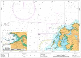
Full details of the survey areas are included in Marine Notice No 25 of 2017, a PDF of which is available to read or download HERE.
#MarineNotice - Shell E&P Ireland were scheduled to commence flowline installation works between two existing subsea wells at the Corrib gas field this week.
This work will be followed by placement of rock protection along the length of the exposed flowline between the two wells.
There may also be some additional rock placement along the pipeline corridor from the offshore field to the landfall at Broadhaven Bay.
The works, due to commence during this last week of July, are expected run for 30 to 40 days.
The first phase of works will all take place within the 500m Safety Zone surrounding the wells P2 and P5, and along the corridor between P2 and P5.
Carried out by the Skandi Neptune (callsign 2HMG8), the work involves the lay of a new flowline between the two wells followed by connection at each end and pressure testing.
Final seabed connections will be completed on the existing seabed control umbilical followed by the commissioning of the P2 well control system.
This work is expected to be completed by mid August, after whic the Nordnes (callsign PHOG) will commence the second-phase rock placements.
The guard vessel Glomar Arctic (callsign H09083) will be on location in the Corrib Field for the duration of the project. Radio warnings will be given to all marine traffic in the
immediate area. All the vessels will be listening on VHF Channel 16 throughout the project.
Details of co-ordinates of the relevant work areas are included in Marine Notice No 29 of 2016, a PDF of which is available to read or download HERE.
Meanwhile, TechWorks Marine were scheduled to deploy two temporary buoys in the Shannon Estuary on Friday 29 July.
The buoys are required for the placement of turbidity sensors before and during a dredge campaign, and will be in place for the next four weeks.
These data buoys, deployed on a single point mooring, are 1.2m wide, are yellow in colour and have a yellow navigation light with a 2nm range, with five flashes every 20 seconds.
Co-ordinates are included in Marine Notice No 30 of 2016, a PDF of which is available to read or download HERE.
#MarineNotice - The latest Marine Notice from the Department of Transport, Tourism and Sport (DTTAS) advises that Shell E & P Ireland Ltd will undertake its annual pipeline and umbilical survey at the Corrib field location and along the pipeline corridor to the landfall at Broadhaven Bay.
There will also be a programme of maintenance and inspection conducted on the subsea facilities when the first phase of works begins later this week. This work will all take place within the 500m Safety Zone and will involve carrying out a programme of maintenance to investigate and repair some of the subsea facilities as required.
Phase 2, the pipeline and umbilical inspection, will be undertaken from 54°20.34’N, 011°03.51’W (Corrib Offshore Field Location) to 54° 17.00’N, 009° 49.24’ W (landfall).
The area of activity stretches along the route of the existing Corrib offshore gas pipeline and umbilical route. The pipeline and umbilical surveys will be separate activities. The work involves acoustic and visual survey of the pipeline and umbilical.
The Phase 1 work will commence in mid April and is expected to be completed by the end of the month. The Phase 2 work will commence upon completion of Phase 1 and is expected to be completed by the end of May.
The Olympic Ares (Callsign C6AW7) will undertake the deep water surveys and the subsea facilities maintenance and inspection. All equipment used will be vessel- and/or ROV-mounted. The vessel will be listening on VHF Channel 16 throughout the project.
A reference map of the Corrib offshore gas pipeline and umbilical route is included in Marine Notice No 15 of 2016, a PDF of which is available to read or download HERE.
#Corrib - A prime example of "how not to undertake a development" – that's how a new planning report by British engineers describes the Corrib gas field project off the Mayo coast, according to The Irish Times.
Two of the authors of the report from the British Institution of Civil Engineers say that had Shell and the State agencies responsible for the controversial gas pipeline taken a more democratic approach, the project may have avoided what's known as 'space shuttle syndrome'.
That's a term used to describe when large-scale projects go wrong, reflected in the Corrib situation, the authors allege, in a number of factors not least budget overruns that have cost Irish taxpayers some €600 million – and the conspicuous "conflict with the local community".
The Irish Times has much more on the story HERE.
Marine Notice: Corrib Field Anchors Pre-Lay For Ocean Guardian Rig; Water Outfall Quality Survey

#MarineNotice - The latest Marine Notices from the Department of Transport, Tourism and Sport (DTTAS) advise of the pre-laying of anchors in the Corrib Gas Field ahead of the arrival of the Ocean Guardian rig, and an inshore seawater sampling survey in the vicinity of the field.
Staring tomorrow and continuing for three days, Shell E&P Ireland Limited will employ the Boa Bison (Call Sign: LDPN) to pre-lay eight anchors on the sea bed in the Corrib Field prior to the arrival of the semi-submersible drilling rig.
The anchors will remain at the locations indicated HERE until the arrival of the Ocean Guardian rig (Call Sign: V7FF7) around the second week of this month, when the anchors will then be attached to the rig.
The Ocean Guardian rig is due to commence operations on well 18/25-1(P2) in the second week of June and remain on location until the end of July/early August. The rig will be listening on VHF Channel 16 throughout the project.
All vessels, particularly those engaged in fishing, are requested to give the rig a wide berth and to keep a sharp lookout in the relevant areas. Full co-ordinates of all work areas are included in Marine Notice No 22 of 2015, a PDF of which is available to read or download HERE.
Meanwhile, an inshore seawater sampling survey is taking place in the vicinity of the Corrib treated surface water outfall diffuser, off the coast of Mayo.
The works, undertaken from the SMS Leah (Callsign MHIU8), were set to begin yesterday Tuesday 2 June and last for around three days, weather permitting. Co-ordinates of the relevant sampling areas are included in Marine Notice No 23 of 2015, a PDF of which is available to read or download HERE.

#MarineNotice - Maintenance and pre-commissioning activities are set to be carried out on the Corrib Gas Field.
The work will all take place within the 500m Safety Zone surrounding the Corrib subsea facilities, and will be carried out by the Normand Subsea (Callsign 2CQP8).
Works will commence around 1 June 2015 and are expected to be completed by the end of the month, weather permitting.
Full details of co-ordinates of the work area are included in Marine Notice No 17 of 2015, a PDF of which is available to read or download HERE.
#MarineNotice - The latest Marine Notice from the Department of Transport, Tourism and Sport (DTTAS) advises of rock placement on the newly installed P3/P6 flowlines at the Corrib gas field, and remedial rock placement on the 20” gas pipeline and control umbilical.
The work will be undertaken at the Corrib field location and along the pipeline corridor to the landfall at Broadhaven Bay. The vessel to be used will be the Nordnes (Callsign PHOG).
Work on the P3 and P6 flowline rock placement will all take place within the 500m Safety Zone surrounding the Corrib subsea facilities. Meanwhile, the pipeline and umbilical remedial rock placement will be undertaken from the Corrib offshore field location to landfall at Glengad, Co Mayo.
The P3/P6 rock placement works will commence tomorrow, Sunday 19 October at the Corrib Field. Following that, the remedial rock placement will be undertaken on the pipeline and umbilical. The work will be completed by early November 2014.
Full details of co-ordinates for the relevant work areas are included in Marine Notice No 59 of 2014, a PDF of which is available to read or download HERE.
Marine Notice: Corrib Gas Field Baseline Environmental Survey & Post Well Monitoring Survey

#MarineNotice - The latest Marine Notice from the Department of Transport, Tourism and Sport (DTTAS) advises that an environmental survey will take place in the vicinity of the Corrib Gas Field manifold and the Corrib treated surface water outfall diffuser.
These works, which include a post-well environmental survey conducted in the area of the 18/20-5(P6) well, were scheduled to commence by today (Friday 26 September) and are expected to last about a week, weather permitting. The vessel to be used is the Granuaile (Callsign EIPT).
Water and sediments samples will be collected from a series of locations adjacent to the Corrib field (SW3) and the water outfall diffuser (SW1) using a grab sampler. All locations at SW3 are within a 2.5km radius of the manifold.
With the exception of a sample control site located approximately 10km to the south-west, all locations at SW1 are within 4km of the diffuser. Cameras mounted on ROVs will take visual images of the seabed at each sample location.
Details of the relevant co-ordinates are included in Marine Notice No 57 of 2014, a PDF of which is available to read or download HERE.

#MarineNotice - The latest Marine Notice from the Department of Transport, Tourism and Sport (DTTAS) advises that annual maintenance and inspection activities will shortly be carried out on the Corrib Gas Field.
The works, being carried out in conjunction with the annual pipeline and umbilical maintenance inspection and flowline installation, will commence on Saturday 2 August 2014 and are expected to be completed by the end of the first week in September 2014.
The works will all take place within the 500m Safety Zone surrounding the Corrib subsea facilities. The vessel to be used will be the Normand Subsea (Call sign 2CQP8).
Full details of co-ordinates for the Safety Zone are included in Marine Notice No 46 of 2014, a PDF of which is available to read or download HERE.
Marine Notice: Deployment Of Waverider Buoy On Corrib Gas Field

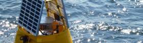
#MarineNotice - The Department of Transport, Tourism and Sport (DTTAS) has been advised that Shell E&P Ireland Limited will be deploying a Waverider buoy in early-to-mid April in order to help predict sea conditions for the Corrib P6 well intervention work by the Ocean Guardian (Call Sign V7FF7).
The buoy size is 90cm in diameter, and will be deployed at the location (approximate, with 100m watch circle) 54° 20’N, 011° 05’W (WGS84), weather permitting. The water depth at this location is 360 metres. The Waverider buoy will remain on site for approximately three months.
The wave rider buoy is yellow in colour, and will flash yellow 5 times every 20 seconds. A photograph of what the buoy looks like in the water is included in Marine Notice 23 of 2014, a PDF of which is available to read or download HERE.
All vessels are requested to give the wave buoy a wide berth.


 Michael Murphy Schull Harbour Sailing Club (SHSC), Eric Coogan Heineken Ireland, Mark Murphy, Commodore SHSC, Jack Allen SHSC, Carmel O'Regan SHSC, Cornelious Ndlovu, Schull Harbour Hotel Operations Manager and Derval Murphy SHSC")

