


Displaying items by tag: Marine Institute
World’s Most Advanced Ship For Monitoring Harmful Algae Completes Survey Of Irish Waters
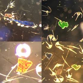
#MarineScience - Blooms of toxin-producing algae and unprecedented levels of microplastic particles were detected in a recent oceanic survey carried out by scientists from the Marine Institute.
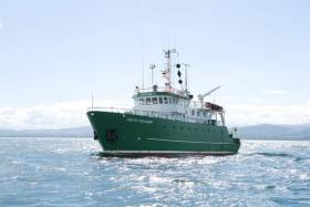
Bristling with sensors and state-of-the-art technology, the German research vessel RS Heincke completed a circumnavigation of UK and Ireland this August in a month-long survey.
A team of six Irish phytoplankton, biotoxin and oceanographic scientists joined the survey, which was conducted by the Alfred Wegener Institute Helmholtz Centre for Polar and Marine Research in collaboration with the Marine Institute and the University of Oldenburg Institute for Chemistry and Biology of the Marine Environment.
A total of 75 stations were surveyed using instrumentation aboard the ship, which was primarily designed to investigate Azaspiracid toxins produced by a number of micro-planktonic species of the family Amphidomataceae.
“This research is important for us as Ireland remains the most affected country in the world by shellfish poisonings caused by toxins produced by these species,” said Joe Silke, senior scientist on the survey from the Marine Institute.
These toxins, which were first discovered 23 years ago during routine monitoring of Irish shellfish, have resulted in annual temporary closures of Irish shellfish production areas, with resulting economic loss from loss of sales and markets.
Recent research has identified that the Amphidomataceae, unlike many other toxic algae, are pelagic plankton found in the open sea to the west of Ireland. These can accumulate in specific cases of currents and wind direction, creating toxin problems in the shellfish production bays along the West coast.
This was the first time that near real-time analysis was possible underway due to the advanced equipment available for the survey, including a fully equipped chemistry lab capable of measuring and identifying trace levels of toxin produced by the plankton using a liquid chromatography mass spectrometry instrument. Only 30 minutes after taking plankton samples aboard a full characterisation of the toxins present was possible with this equipment.
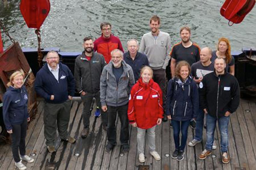 Irish and German scientists aboard the RS Heincke for the HE516 phytoplankton survey of the North Sea, English Channel and Atlantic Shelf | Photo: Marine Institute
The team of scientists on board were able to confirm the presence of these phytoplankton at several offshore and nearshore stations, and collected an integrated data set comprising oceanographic, bio-optical, meteorological, plankton and sediment data accompanied by taxonomic determinations, toxin measurements and DNA analysis.
“Having the capability to carry out near real-time analysis of microscopic plankton while at sea to reveal the species present and their toxins is a huge leap forward in opportunities for our research programmes,” Silke said.
Simultaneous research activities included taxonomic analyses of the filtered plankton. Scientists used high resolution microscopy, further supported by real-time analyses of the plankton using molecular biological technology designed to recognise the DNA fingerprint of individual species.
Automated instruments on board such as a FerryBox carried out physico-chemical analysis of underway water, and a Flow-Cam carried out automated particle measurements and image analysis of phytoplankton samples. Full bio-optical properties of the water were measured using instruments on the ship measuring spectral properties both above and in the water.
In the course of the survey, several other blooms of algae were detected along the oceanographic fronts traversed by the ship’s track. These included large blooms of the usual late summer phytoplankton that we commonly see in coastal waters. These comprised mostly diatoms and dinoflagellates, such as Dinophysis acuta that produce DSP shellfish toxins, and Karenia mikimotoi that can cause fish and invertebrate mortalities if it accumulates in coastal areas.
The survey also revealed several species of Azadinium, the target group for this survey. These included some rare species, and some that have not been recorded previously in Irish waters.
One unexpected observation in the plankton net hauls was the diverse and frequent observation of microplastic particles in the same size range as the phytoplankton. While the survey was not looking for these in particular, it was evident that their occurrence is more widespread than observed in previous surveys in offshore waters, and would also appear to be diverse in nature based on shape and colour.
The European Food Safety Authority stated recently that plastic particles of this nature are less likely to pass to humans through fish, because the they do not pass through the intestine into other tissues of finfish, and the digestive tract is normally discarded. They may, however, pass to the food chain through filter-feeding shellfish species where the GI tract is consumed.
The sizes of particles observed on this survey would lend support to this, although the risk of exposure to humans and its consequence on health requires more research.
#MarineScience - A UCC-led group of scientists from across the globe have revealed a submarine canyon on the edge of Ireland’s continental shelf, 320km west of Dingle, after mapping an area twice the size of Malta.
The group returned last Friday (10 August) after a research expedition on board the Marine Institute’s RV Celtic Explorer with ROV Holland I, mapping 1,800 sqkm of seabed to image the upper canyon over a fortnight.
Scientists say the find is significant in understanding more about how submarine canyon helps transport carbon to the deep ocean.
Although there is excess CO2 in the atmosphere (the greenhouse effect), the ocean is absorbing this at the surface, and canyons pump this into the deep ocean where it cannot get back into the atmosphere.
The expedition, led by Dr Aaron Lim of UCC’s School of Biological, Earth and Environmental Sciences (BEES), utilised the Marine Institute’s remotely operated vehicle (ROV) Holland I and state-of-the-art mapping technologies to learn more about the nature of the canyon.
“This is a vast submarine canyon system, with near-vertical 700m cliff in places and going as deep as 3,000m. You could stack 10 Eiffel towers on top of each other in there,” Dr Lim said. “So far from land this canyon is a natural laboratory from which we feel the pulse of the changing Atlantic.”
According to Dr Lim, this discovery coupled with recent findings on the Irish-Atlantic margin – including rare sponge reefs and a spectacular mountain range in the mid-Atlantic – shows the advances in both Ireland’s marine technology and scientific workforce. “Ireland is world-class, and for a small country we punch above our weight,” he said.
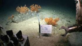
The Porcupine Bank Canyon is the westernmost submarine canyon on the contiguous Irish margin 320km west of Dingle and exits onto the abyssal plain at 4,000m water depth. The upper canyon is full of cold-water corals forming reefs and mounds which create a rim on the lip of the canyon 30m tall and 28 km long.
The coral reefs on the rim of the canyon eventually break off and slide down into the canyon, where they form an accumulation of coral rubble deeper within the canyon.
The ROV ventured deeper into the canyon and found significant build-ups of coral debris that have fallen from hundreds of meters above.
“This is all about transporting carbon stored cold water corals into the deep. The corals get their carbon from dead plankton raining down from the ocean surface so ultimately from our atmosphere,” said Prof Andy Wheeler of the School of BEES at UCC and the Irish Centre for Research in Applied Geosciences (iCRAG).
“Increasing CO2 concentrations in our atmosphere are causing our extreme weather; oceans absorb this CO2 and canyons are a rapid route for pumping it into the deep ocean where it is safely stored away.”
The new detailed maps show lobes of sediment debris and the scars from submarine slides as the canyon walls collapse. There is also exposure of old crustal bedrock and incised channels in the canyon floor carved by sediment avalanches.
“We took cores with the ROV Holland I and the sediments reveal that although the canyon is quiet now, periodically it is a violent place where the seabed gets ripped up and eroded,” Prof Wheeler added.
The new mapping data shows a rim feature along the lip of the canyon at approximately 600m water depth.
“When we sent down the ROV, we saw that this rim is made of a profusion of cold water corals, which appears to extend for miles along the edge of the canyon,” said Prof Luis Conti of the University of Sao Paulo, Brazil.
The research supports the shared vision of the Atlantic Ocean Research Alliance, which includes the ongoing cooperation on ocean science and observation in the Atlantic Ocean.
The research has been funded by Science Foundation Ireland, Geological Survey Ireland and contributes to projects in the iCRAG. This research survey was also carried out with the support of the Marine Institute, funded under the Marine Research Programme 2014-2020 by the Irish Government.
Prof Wheeler’s Marine Geology Research Group in the UCC School of BEES is undertaking a research project to monitor the range of coral habitats within this canyon with the aim of understanding what drives these habitats, how they change through time and how sensitive they are to disturbances.
‘Bob The Buoy’ Retires Ashore To Valentia Island
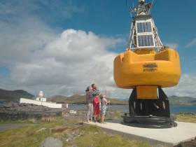
#Buoys - After more than two decades of service as part of the Marine Institute’s national weather buoy network, the affectionately named ‘Bob the Buoy’ will see out his retirement as a permanent resident at Valentia Lighthouse.
Bob withstood countless storms over the years, reporting hourly weather observations to Met Éireann and European partners.
Now visitors to Valentia Island in Co Kerry can check out Bob’s new home at Cromwell Point and get a closer insight into Ireland’s marine navigation and safeguarding history.
“Weather buoys are a fundamental aspect of our maritime history, and it is our hope that Bob will emphasise this in his new location here, on Valentia, the most extreme south-westerly point of Europe,” said Paul Duff, member of the lighthouse committee which worked closely with the Marine Institute on the buoy’s relocation.
“It is fitting that he should be placed here, and we look forward to incorporating him into our visitor experience,” Duff added.
Lighthouse committee chair Brian Morgan said: “This is such a fantastic artefact. It is our hope that we can reinstate Bob, a working retirement if you like, in order for us to provide a weather feed which we can share through our community, and lighthouse network, utilising the available technology, but we will let him settle in first.”
Dr Guy Westbrook from the Marine Institute said he and his colleagues are delighted that Bob has a new home at Valentia to educate the public about the weather buoy network.
“Designed to improve weather forecasts and safety at sea around Ireland, the buoy network provides vital data for weather forecasts, shipping bulletins, gale and swell warnings as well as data for general public information and research,” Dr Westbrook added.
In other news, the large marker buoy found adrift by Clifden RNLI in late July has been removed from the Connemara coast.
Harry Duggan of the Commissioners of Irish Lights says the buoy, which originated in Canadian waters, was as of yesterday (Friday 10 August) on its way to CIL headquarters in Dun Laoghaire.
The CIL recommends caution around any and all aids to navigation around the Irish coast.
Shiptime Charter Applications For 2019 & 2020 Now Open
#MarineScience - Applications are open for shiptime in 2019 and 2020 on Ireland’s national research vessels Celtic Explorer and Celtic Voyager, as well as the ROV Holland I and the Laochra na Mara glider.
Every year a broad range of organisations use the Marine Institute’s vessels for research, development and monitoring programmes. These include Government departments and agencies, universities, research institutes and industry.
Applications for shiptime for 2019 and 2020 must be submitted using Research Vessel Operations’ online Survey Planning System (SPS) by Thursday 20 September. Please contact Research Vessel Operations to obtain an SPS login if you don’t already have one and to inquire about glider availability.
Each application will be reviewed and the applicant will be informed as soon as possible whether the shiptime they requested is available. If the requested shiptime is not available, alternative dates may be offered. The Vessel Charter Guidelines should be read carefully before submitting the ship time application form.
Applicants may seek grant aid to cover all or part of the vessel charter costs for research surveys or ship-based Training Programmes. The closing date for receipt of grant aid applications is 5pm on Friday 21 September.
Applicants for ship-based training are advised to consult with the Strategic Marine Alliance for Research and Training (SMART) at [email protected].
The survey schedules can change during the year, therefore please contact Research Vessel Operations to check whether any survey slots remain for 2018 or to be notified if any dates become available.

#OurOceanWealth - New research from NUI Galway’s Socio-Economic Marine Research Unit (SEMRU) focuses on the ecosystem service benefits that society receives from Ireland’s marine environment.
The latest bi-annual report — Valuing Ireland’s Marine Ecosystem Services — was launched at the recent fifth annual Our Ocean Wealth Summit in Galway by Damien English, Minister of State for Housing and Urban Development, and Seán Kyne, Minister of State for Natural Resources, Community Affairs, and Digital Development.
Marine ecosystem services are provided by the processes, functions and structure of the marine environment that directly or indirectly contribute to societal welfare, health and economic activities. These services are vital to ensuring blue growth in Ireland’s ocean economy, which was valued at €1.8 billion or approximately 1% of gross domestic product (GDP) in 2017.
Factoring marine ecosystem service values into ocean economy account frameworks may help to ensure a sustainable ‘blue economy’ for Ireland by making sure that growth in the ocean economy does not exceed the carrying capacity of the marine environment.
While the value of some of these goods, such as fishing and aquaculture, are somewhat easier to measure, the value of many other benefits — such as carbon sequestration, waste assimilation and marine-related recreation — are often not captured by a price in any established markets.
However, without incorporating these values into marine planning processes, these benefits may be ignored or underestimated leading perhaps to suboptimal decision making.
Marine Institute chief executive Dr Peter Heffernan welcomed the new report, commenting: “This assessment of Ireland’s marine ecosystem services and their value is an important step in incorporating ecosystem services into policy and decision making related to Ireland's marine and coastal zones.”
SEMRU director Dr Stephen Hynes added: “Blue growth is about fostering development in marine economic activities in such a manner that the long term ability of the marine environment to continue to provide ecosystem service benefits is not compromised.
“This is exactly what Harnessing Our Ocean Wealth: An Integrated Marine Plan for Ireland is aimed at achieving. Knowing what those benefits are and what they are worth is vital for deciding on the best use of our marine resources and to ensure blue growth for our ocean economy far into the future.”
Commenting on the significance of the report, Dr Micheál Ó Cinnéide, director of the office of communications and corporate services at the Environmental Protection Agency (EPA), said it “adds greatly to our understanding of the value of our marine province. Anybody who was able to see the marvellous RTÉ documentary on Ireland’s Deep Atlantic in 2018 and who follows the pioneering work of researchers in the Marine Institute, Galway and Cork can appreciate that we are unlocking the treasures of our offshore world.
“As this report shows, the true value has to include the natural capital, economic potential, cultural and spiritual values. The EPA and the Irish Forum on Natural Capital looks forward to a wider national debate on safeguarding this priceless marine ecosystem for future generations.”
Valuing Ireland’s Marine Ecosystem Services is based upon research supported by the EPA and is based on previous research conducted under the Marine Institute’s Beaufort Award.
The full report is available to download from NUI Galway, with the technical version on the EPA website.
Summary of economic contribution of marine ecosystem services:
- The provisioning marine ecosystem services of fisheries and aquaculture is estimated to be worth €473 million per annum to all fleets and producers operating in Irish waters.
- Seaweed harvesting is valued at €4 million and aquaculture at €150 million.
- The regulating and maintenance ecosystem services of carbon sequestration are valued at €815 million per annum, waste assimilation services €317 million and coastal defence services of €11.5 million.
- The cultural ecosystem services of scientific and educational services are valued at €11.5 million, and the added value per annum to housing stock of being at the coast (aesthetic services) is valued at €68 million. On an annual basis, recreational services provided by the marine ecosystems are estimated to have an economic value of €1.7 billion.
- Even though not all of the ecosystem services provided by the marine environment can be monetarised, the report indicates that the value of those that can is substantial.
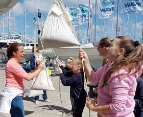
#MarineScience - Irish Sailing’s Cara na Mara programme teamed up with the Marine Institute’s Explorers Education Programme this month in encouraging primary schools to engage with the marine environment.
Clubs involved with the programme, that aimed to offer “a dynamic learning experience” while also enjoying sailing, included Galway City Sailing Club, where Joss Myers offered a blend of ocean literacy and beach cleanup followed by Topaz sailing in Galway Bay.
At Howth Yacht Club, Quest with Sarah Robertson integrated her hands-on learning in STEM and how it applies to sailing, and each child got to sail on the J80 club sailing fleet.
Rathmullan Sailing Club with Aengus Kennedy looked at the flora and fauna in their local beach habitats and used their fleet of Bahias to go on trips exploring the Donegal coastline.
And at Foynes Yacht Club, Elaine O’Mahony looked at integrating environmental awareness and marine literature and history while sailing club boats in the maritime village.
Irish Sailing hopes that many of the students who trialled the Explorers element will come back over the summer to start their Cara na Mara junior courses as part of their sailing pathway.
For further information on this initiative, contact Ciarán Murphy at 087 880 0744 or [email protected].
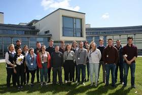
#MarineScience - Twenty-five third level undergraduates have joined the Marine Institute this summer to gain work experience in variety of areas including fish and shellfish assessment and monitoring, catchment research, and the management of the national research vessels as well as maritime finance.
The Marine Institute’s annual Bursary Scheme is already well under way for 2018, with students from a wide range of disciplines from all over Ireland taking part in a variety of exciting 8-12 week programmes.
“The bursary programme gives students an opportunity to gain valuable experience within their chosen subject field,” says Helen McCormick, senior laboratory analyst. “Previous bursars have gained various positions within the Marine Institute at all grades up to and including director level.”
The bursars are working at a variety of different sites all over the country, with many in the Marine Institute at Oranmore, and others working from the institute’s catchment research facility in Newport, Co. Mayo.
Bursars are also working at local sites in Cork, Waterford and Derry, where they are taking part in wild salmon assessment and fisheries sampling.
Dr Peter Heffernan, CEO of the Marine Institute, welcomes the students, saying: “The marine bursary is an extremely well-established scheme that strives to provide students with the necessary skills they will need to succeed in areas related to marine science. The institute is delighted to support this excellent learning opportunity for Irish students."
Many of the students will be taking part in frontline research projects in laboratories, whereas others will be working with the policy team and the communications department in corporate services.
Ocean literacy and communication are a huge part of the bursar experience at the Marine Institute and so over the next month, many of the students will be helping with the Our Ocean Wealth Summit and SeaFest 2018, which take place later this week in Galway.
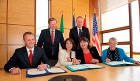
#MarineScience - Five years ago this month, the Galway Statement on Atlantic Ocean Cooperation was signed and the Atlantic Ocean Research Alliance (AORA) between the European Union, Canada and the United States of America formed.
In the time since, the AORA has already been recognised as a success story in the Atlantic area, highlighting international best practices, and promoting the key priorities of the European Union’s Atlantic Strategy and Atlantic Action Plan, embodied in the Galway Statement and its potential support to the Blue Economy.
Today there are more than 500 research teams working in the Atlantic Ocean. Transatlantic co-operation has been embedded and embraced at the heart of the scientific teams working together in Atlantic-wide field campaigns on seabed mapping, ocean observation, seafood, weather, climate and polar research, marine biotechnology and marine spatial planning.
The Galway Statement has also provided the first step in all-Atlantic co-operation, leading to the signing of the Belém Statement on Atlantic Research & Innovation Cooperation between the European Union, South Africa and Brazil. An all-Atlantic research community is also being built.
New transatlantic institutional structures have been formed, including an Ocean Frontier Institute in Canada which includes European and US partners.
Speaking about the achievements to date, Dr Margaret Rae, director of AORA co-ordination and support action at the Marine Institute, said: “AORA is using the latest technology to map the Atlantic, making groundbreaking discoveries like previously uncharted undersea volcanoes and mountains, circulation patterns, and more.
“Our coordinated efforts are helping to create a blueprint for the next generation of ocean observation. And there’s still much to uncover, from new sources of energy and food to lifesaving medicines found in unexpected sources.
“By learning all we can about our oceans, we can create a world with better navigation, weather prediction, smarter search and rescue, health, and a thriving seafood industry that will feed generations to come.”
Transatlantic research teams with Horizon 2020 funding have unearthed new discoveries and knowledge:
Seabed Mapping
- Completed seven opportunistic transatlantic surveys by Irish, Canadian, French and Fugro vessels, resulting in discoveries of uncharted seamounts kilometres high, deep sea volcanoes, and ridges some hundreds of kilometres in length.
- Developed a collaborative model for industry, research and government to promote Atlantic seabed mapping and open data.
- Encouraged private sector participation for public good, resulting in Fugro contributing more than 65,000 sq km of high resolution data. Fugro maps the seabed while transiting between offshore projects.
Ocean Observation
- Completed an analysis of Atlantic-wide observation system capacities/gaps.
- For the first time a team has formed to develop a blueprint for an Atlantic-wide integrated ocean observing system with wide Atlantic participation.
Atlantic Ecosystems
- Co-ordinated expeditions to map deep-sea Atlantic ecosystems and advanced knowledge of key species, ecosystems and processes.
- Discovered modern Atlantic Ocean circulation which is atypical of the longer term.
- Deployed new sensors in eastern subpolar North Atlantic to enable key advancements in understanding of ocean physics interactions.
- Provided scientific evidence that temperature change, acidification, fisheries and their cumulative effects pose the greatest risks to ecosystem services.
- Successfully tested a generic Marine Spatial Planning (MSP) framework to assess spatially managed areas (SMAs) across the North Atlantic.
Seafood
- For the first time, climate vulnerability assessments of North Atlantic fish and shellfish, including the human communities dependent on these have been rigorously compared across the EU, US & Canada – strengthening scientific cooperation and building better forecasts.
- Made the first steps to use marine algae to build ‘blue belts’ for carbon/nitrogen sequestration and sustainable aquaculture.
Ocean Education
- Developed a transatlantic ocean literacy strategy and a range of new ocean educational materials (videos, teaching modules, infographics).
Weather, Climate & Polar Research
- Worked together to study Arctic warming impacts, ecosystem productivity and ocean-climate dynamics to give new understanding to local populations.
- Facilitated co-operative understanding of the impact of a changing Arctic on weather and climate across the northern hemisphere.
- Worked with public and private users of climate information to help them incorporate uncertain scientific evidence into real-world decision-making processes.
For more information see www.atlanticresource.org.
DNA Testing Continues To Confirm Cause Of Cork Carp Kill
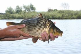
#Angling - Scientists at the Marine Institute’s Fish Health Unit are conducting further testing on sample carp from The Lough and Belvelly in Cork after the recent outbreak of suspected carp edema virus.
The tests include sequencing of the viral DNA to confirm its identity, and until confirmed the current findings shall be regarded as preliminary, according to a statement from the Marine Institute.
Molecular tests for Koi Herpesvirus Disease (KHV), a listed disease under European Fish Health legislation, were negative for all fish sampled. Additional molecular tests for cyprinid herpesvirus (other than KHV) were also in progress as of yesterday, Thursday 17 May.
The gills and skin of the sampled fish revealed an extremely high infestation of trichodinid parasites along with a fungal infection. White spots on the scales were also microscopically examined but there was no evidence of Ichthyophthirius multifilius infection.
Virological screening for Spring Viraemia of Carp is still ongoing with no virus observed to date. Bacteriological tests have revealed no growth of bacteria.
“While we’ve identified the presence of CEV — known to cause koi sleepy disease — in all the samples tested to date at the Marine Institute, we are still carrying out further tests for confirmation of the cause of the carp mortalities at The Lough and Belvelly lake,” said Dr Neil Ruane from the Fish Health Unit.
Dr Jeff Fisher, director of marine environment and food safety service at the Marine Institute, added: “Though the ultimate cause of the introduction of the disease agent into the loughs cannot be determined from current information, the loss of significant numbers of carp in these two lakes highlights the need for vigilance among anglers and other recreational users of Irish waters in the cleaning of their equipment and gear thoroughly after use, and also for the need for fishery owners and members of the public to be aware of the potential risk of transferring fish that may carry disease into the wild, and to never release ornamental fish into lakes or rivers.
“We’re continuing to work closely with Inland Fisheries Ireland and Cork City Council, and the Cork Carp Anglers Club to determine the cause of this fish kill, contain the incident, and identify appropriate biosecurity measures for the future.”
More than 750 carp were lost in the outbreak at The Lough in Cork city centre earlier this month, with the Cork Carp Anglers Club estimating the cost of replacing even a fraction of this number at €200,000 or more.
Cork City Fish Kill: Carp Test Positive For Edema Virus
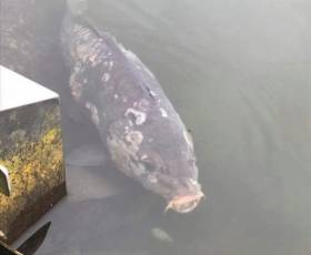
#Angling - Scientists of the Fish Health Unit at the Marine Institute have advised that sample carp taken from The Lough and Belvelly Lake in Cork have tested positive for carp edema virus, or CEV.
The poxvirus causes a disease known as ‘koi sleepy disease’ in both koi and common carp.
The fish kill was first reported at The Lough in Cork city centre last week, with subsequent reports at Belvelly Lake in Cobh. Some 450 carp were removed from the former, and over 20 from the latter, as well as live samples from both for analysis.
At present, while tests are ongoing and further tests are carried out on the CEV detected, this is being treated as a ‘suspect positive’ and is not confirmed as the causative agent of the mortalities until all tests have been completed.
Inland Fisheries Ireland (IFI) recommends that stringent biosecurity protocols continue to be implemented. All mortalities continue to be removed and disposed of in a bio-secure manner.
Angling remains suspended at both locations, as well as at Inniscarra and Carrigadrohid Reservoirs.


 as lead helm, rounds the Fastnet Rock on the way to the overall win in 1987")


